Weather Outlook – Friday 10 October 2025
Regions: SE QLD & NE NSW
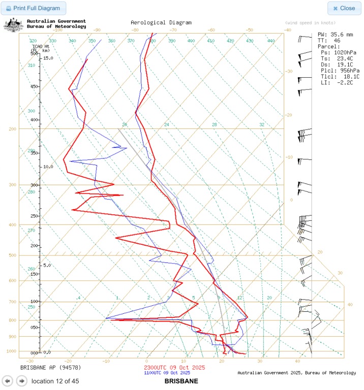
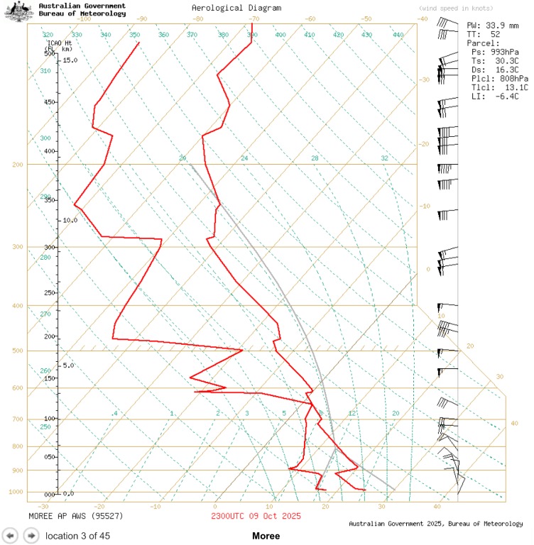
Compared to Wednesday’s forecast soundings, today’s soundings from Brisbane and Moree show:
Higher low-level moisture (notably deeper mixing ratios through 850–700 hPa)
Slightly weaker capping across the inland slopes
Cooler mid-level temperatures, which steepen lapse rates and help parcel buoyancy
These shifts indicate a more favourable environment for storm initiation and intensity than earlier in the week.
Expected Development:
Initiation: Mid to late afternoon (2–5 pm), most likely inland from the ranges where heating and moisture overlap.
Storm Type: Initially pulse to multi cell storms, with potential for isolated severe cells moving eastward toward the coastal fringe.
Possible Key Hazards:
Large hail in drier mid-level zones west of the range (Darling Downs–Moree corridor)
Strong downdrafts given DCAPE profiles and developing dry slot aloft
Localised heavy rainfall in coastal or Ranges, where moisture convergence is stronger
Confidence and Coverage:
Inland (Darling Downs / N Tablelands): Moderate to high confidence in storm development
Coastal SE QLD / NE NSW: Moderate probability; coverage may depend on boundary layer recovery and coastal convergence zones
Severe potential: Scattered but genuine, particularly if inland updrafts can remain organised into the evening.
So to put simply,
Storms are more likely today than models showed earlier in the week.
Warm, moist air has pushed inland and the “lid” or cap that was stopping storms from forming has weakened.
If you’re inland (Moree, Dalby, Toowoomba): Expect afternoon storms, some could turn severe with large hail, strong winds, and heavy rain.
If you’re on or near the coast (Brisbane, Gold Coast, Sunshine Coast): There’s a chance of a few storms later today, especially where sea-breeze and inland air meet — but they’ll be more scattered.
Best window: Mid-afternoon through evening.
Once again, this is my summary of what I think could happen and should not be used as a warning, please keep and eye to the sky and radar, and listen for any warnings if storm do build and become severe. As per usual things do and can change.
This mornings soundings