🌩️ Sunday 12 October 2025 – Storm Outlook and rain potential
Technical Breakdown
Today’s setup is a classic example of how promising upper-level conditions can still fall flat when low-level moisture doesn’t want to play the ball.
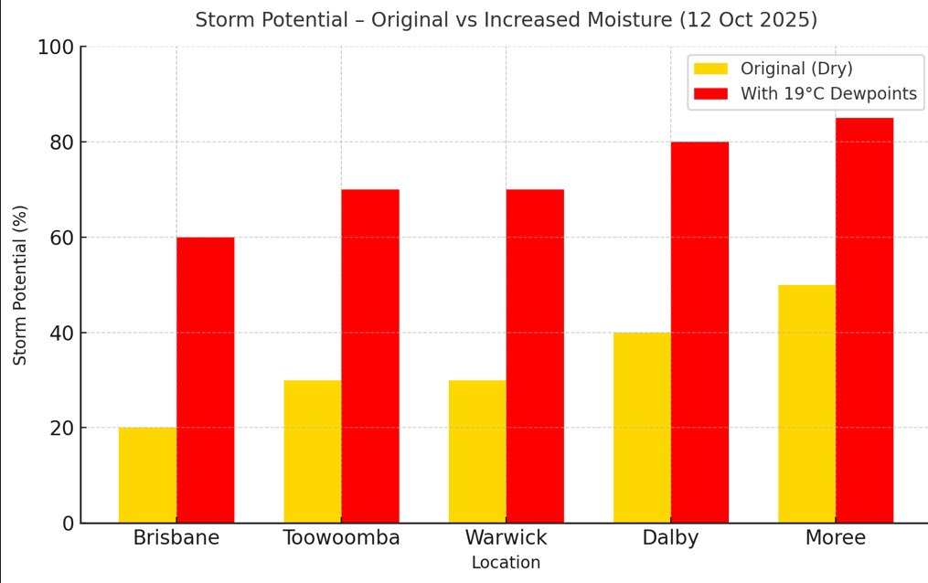
Soundings from Brisbane, Toowoomba, Warwick, Dalby, and Moree all tell a similar story — a strong cap sitting firmly in place between roughly 850–700 hPa, combined with low dewpoints that limit parcel buoyancy. Surface moisture mixing has reduced dewpoints across the Downs and western regions, leading to CIN values too high for sustained convection.
CAPE is present but shallow, and the LCLs are too high for efficient storm initiation. Even if something does try to break the cap, updrafts will likely become more entrainment-loaded and collapse quickly.
When each profile is re-run with 19 °C dewpoints (a modest moisture increase), the picture changes dramatically:
The cap weakens enough to allow isolated updrafts.
CAPE rises notably, especially inland.
The overall storm structure potential improves — hinting that moisture alone is the missing link today.
So, in technical terms: the ingredients are half-baked. The atmosphere has the heat and lift, but not the moisture to get things cooking so to say.
To put it simply
It’s one of those days where it looks like storms could form — but the air near the surface is just too dry.
That invisible “lid” or cap on the atmosphere is holding things down tight.
Even though it’s warm enough and the upper winds look good, there just isn’t enough moisture to get proper storm clouds going.
If the air was a few degrees more humid — like those 19 °C dewpoints — we’d likely be seeing scattered storms bubbling up inland.
As it stands, expect a warm and dry afternoon, with maybe a few teasing cumulus towers that fizzle out quickly.
Storms today are unlikely, and any that do pop up will struggle to sustain themselves.
This is a great example of how one missing ingredient — in this case, moisture — can completely change the forecast outcome.
You could almost say we’re just one dewpoint away from a storm day!
Here is a comparison with the forecast soundings and then adding a modest amount of moisture into the mix.
I will add the rain potential below as well. Today is looking dry but over the next 30 plus hours it does improve.

Plus 30 hours

We need to wait and see what the sounding is like as well from the balloons released this morning.
Please note that this is only my interpretation and things can be completely different . I didn’t even have time this morning to add the EC models into the equation.
BoM are running their forecast through supercomputers and are using an Access model that is not for the public then they are able to compare that with the European models that once again are not for public use. We can use a limited variation of the models for free or you can open things a bit wider by paying a subscription. But the fun is trying to forecast with limited modelling systems.
So please keep your eye and ears open to any warning or storms if they do build and become severe. Have a great day
