BoM have released the latest sounding for Brisbane. It is interesting this morning I played around with the dew points as I thought the models had under done them. So in summary looking at the 3 soundings Model, Model with adjusted Dew points and the actual we have a slightly different picture. Not a great deal when comparing the last 2 soundings.

This is the version where I increased the dew points to 19°C
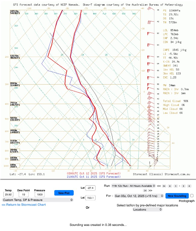
The actual sounding from the Airport.

Analysis of the charts

The GFS forecast clearly underestimated low-level moisture for Brisbane today, producing a deep dry layer with no CAPE and significant capping (CIN 137 J/kg). When a realistic 19°C surface dewpoint was introduced, CAPE jumped above 1500 J/kg, CIN reduced substantially, and the environment became conditionally unstable.
The observed sounding this morning verifies that outcome almost exactly — surface dewpoint near 19°C, similar CAPE (≈1200–1500 J/kg), and LI around -6°C. The cap is weak, and with surface heating to 33°C, the environment now supports isolated convective initiation if lifting mechanisms align.
Moisture depth and the higher PW (42.8 mm vs 34 mm forecast) confirm a much moister boundary layer than the model.
Shear remains moderate (~35–40 kt), enough to sustain organised updrafts should storms develop.
In summary — the real atmosphere followed the adjusted version, not the model. GFS missed the moisture return and therefore underplayed storm potential for SE QLD.
So to put that simply
Brisbane’s morning weather balloon shows a big difference from what the models had suggested. The real air is a lot more humid, with dewpoints around 19°C instead of the 13°C forecast.
That extra moisture means the atmosphere is more unstable, with energy now available for storms (CAPE around 1400 J/kg).
It’s still not a classic setup — we’ll need a bit of lift or a boundary to spark anything — but it explains why the air feels heavy and “stormy” today.
In short, the models were too dry, and the real atmosphere looks much more supportive of isolated afternoon storms, especially inland where heating is stronger.
So once again this is only my interpretation of events. So please keep an eye and ear out just in case. Being outside compared to looking at the charts and models gives you a different perspective, so that is why I thought I would re run or replot the models this morning and create a new sounding.
Cheers
