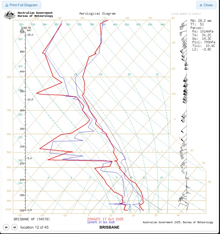


What I have done is loaded the realtime Sounding for Brisbane and Moree and I added the model forecast Sounding with increased dew ponts as per the observations currently for Brisbane ( image 2.) . There is a bit more moisture than the other day as can be seen in the higher Dewpoints.
So what is the takeaway in technical terms.
Soundings show a moderately unstable boundary layer with stronger instability inland. Surface temps ~31 °C with dew points mostly mid-teens (14–16 °C) — higher than the previous day and enough to support moderate CAPE where mixing is sufficient.
GFS forecast profile indicates CAPE ~1.4 kJ/kg with LI around −4, PW ≈ 31 mm. Realtime Moree shows deeper instability (LI ≈ −7) than coastal Brisbane (LI ≈ −3.8).
Wind shear is modest but adequate (0–6 km ~30–40 kt) to support organized multicell clusters and isolated supercell modes inland.
Thermodynamic profile
Low-level: surface T ~31 °C, Td mid-teens → moderate low-level humidity. LCLs are relatively low (good for convection initiation if surface convergence occurs).
Mid-level lapse rates: steep in many profiles → favorable for hail growth (strong mid-level lapse rates support strong updrafts / freezing-level hail formation).
Freezing level around 3.5–4.0 km (sufficiently low for hail to survive to ground if cores are strong).
And to put that into simple English, to break it down it basically means Warm surface temps (around 30–32°C) and mid-teen dew points mean there’s a fair bit of heat and moisture building up.
Soundings from Brisbane and Moree show moderate instability — the air higher up is much colder, which can help strong updrafts form.
A change/trough line is sweeping through later today. That boundary could be the trigger that gets storms going.The timing of the change is still the unknown to be exact.
🌩️ Storm Potential
Most likely area: Inland SEQ & NE NSW — roughly from Moree to Warwick, Dalby, and Kingaroy.
Coastal areas (Brisbane, Sunshine Coast, Gold Coast): Possible, but less likely unless storms drift in from the west.
🌀 Main Threats
Hail: A few storms could produce small to large hail.
Strong Winds: Gusty outflow winds possible with collapsing storms.
Lightning: Frequent, especially in the early stages of development.
Rain: Short bursts rather than long downpours.
So The Key Things to Watch out for
If dew points stay in the mid-teens (15–17°C), that’s a good sign storms could strengthen.
Keep an eye on radar this afternoon — isolated cells could quickly turn strong.
The window for storm activity looks to be late afternoon into early evening with the expected change or the another words , the trough should move off the Coast..
There’s a good chance of scattered storms, with a few possibly severe.
So once again, these are my interpretations of the models and things can change quickly. It really is a wait and see approach today, so keep an eye to the sky and radar and if storm do build, then listen for any warnings that may follow if they become severe. A little bit of a tricky set up and it comes down to timing and the atmospheric conditions to be primed. The potential is there.
