Storm potential for Monday 3 November .
We should see showers develop in the afternoon but if everything comes into play at the right time we could see a
dynamic setup unfold across inland and southeast Queensland and NE NSW today with a trough and approaching cold front combining with deep instability and rich surface moisture.
Soundings from Moree through to Gympie reveal a classic west-to-east gradient — drier but more unstable inland, moister and capped near the coast.
If the inland trough and hot NE flow link up through the afternoon, we could see explosive convection, that may produce large hail, damaging winds, and intense rainfall. Later, as boundaries and the sea-breeze interact closer to the coast, isolated but powerful cells could still develop into the evening hours.
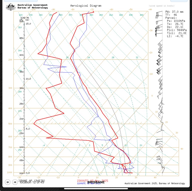
Brisbane (actual 23Z sounding):
Earlier analysis showed Brisbane’s sounding with lower TT values (low 50s) and a more stable cap compared to inland locations. The profile was cooler and moister near the surface but with weaker lapse rates aloft.
This pattern favours coastal convergence storms late in the day, particularly if inland outflows or the sea-breeze front interact. Expect mainly pulse to short-lived multicells, heavy rain, and isolated strong gusts rather than widespread severe activity. However, any inland cell tracking east could intensify briefly upon reaching the coastal moisture plume.
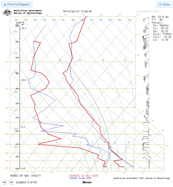
Moree
PW: 23.8 mm TT: 48 LI: −4.9 Ts: 33 °C Ds: 16.2 °C
The Moree profile shows a drier low-level column but strong mid-level lapse rates and a deeply unstable environment aloft. CAPE potential is high but conditional — surface dryness limits convection unless forced by a boundary.
The approaching trough and cold front from the southwest will provide that lift, colliding with a hot, gusty northeast flow feeding inland. If this moisture reaches the region in time, storms could develop quickly and become severe with large hail and strong wind gusts. If the low levels stay dry, convection will be more isolated but capable of producing intense microbursts and elevated hail cores.
In short: volatile but conditional — a true “hot vs cold” battleground

Gympie
Gympie’s profile indicates good surface heating, modest CAPE, and steep lapse rates through the lower mid-levels, but like Brisbane, is more moisture-driven than dynamically forced.
If outflows from inland storms reach the coast late in the day, the resulting boundary collisions could trigger isolated but intense updrafts. Hail is possible due to cold upper levels, but the more likely threat would be localised flash flooding and strong microbursts under any collapsing storm.

Dalby
Surface Pressure: 962 hPa Ts: 31.2 °C Td: 14 °C CAPE: 1346 J/kg LI: −3.8 TT: 53.2 °C
Dalby sits closer to the moisture axis and shows moderate CAPE and limited CIN. The profile supports explosive convection if parcels can reach the LFC. The Lifted Index and Total Totals both indicate a strongly unstable mid-layer, while the K-Index near 33 suggests moisture sufficient for deep convection.
Winds are slightly veered through the lower levels with weak helicity, so multicell clusters or short line segments are most likely, but with 1-4 cm + hail and damaging winds possible if updrafts anchor on the trough.
Overall Picture
Instability: strongest inland (Dalby–Moree), tapering toward the coast.
Moisture: slowly improving east of the trough line as NE winds deepen.
Forcing: trough/cold front provides the main trigger; sea-breeze and outflows secondary.
Storm mode: multicell clusters inland, possibly a few supercell-type updrafts early; then merging into line segments as the boundary pushes east.
Timing: mid- to late-afternoon inland, evening toward the SE coast.
The latest soundings from Moree, Dalby, Brisbane, and Gympie show a strongly unstable atmosphere inland that gradually stabilises toward the coast.
Moree and Dalby have the highest energy, with a hot, dry lower layer and a cold front from the southwest expected to provide lift later today. If the incoming NE moisture connects in time, severe storms with large hail and damaging winds could be likely.
Farther east, Brisbane and Gympie show a moister but less unstable profile, so storms will be more isolated — though any that develop could still pack heavy rain and gusty winds.
Bottom line: Inland areas remain the most at risk for severe storms this afternoon and evening “if” everything comes together, ( that is the big ???, timing) while coastal regions may see scattered cells later as outflows and the sea-breeze interact. Keep an eye on radar and official warnings.
So please once again, these are my thoughts and things can change. Please stay vigilant if storms develop and listen for any warnings that may be required if cells become severe. So keep an eye to the sky and radar and please stay safe in case you are under one of these cells if they develop.
