Originally Posted by: i4hanish 
I will post this GFS (bcsh stormcast) rain forecast for tomorrow evening around 7pm. The model is giving some lucky sole a possible maximum of 19mm out west of Brisbane way
I would like to see how this forecast plays out.
BTW. The storm line is still active out in central QLD
https://www.lightningmap...ceania/index.php?lang=en
This is where the soundings come into play. LI,s and Cape are only 2 ingredients. You can have LI’s of -5 and have blue skies. You can have LI’s of -1 and you could have a tornado.
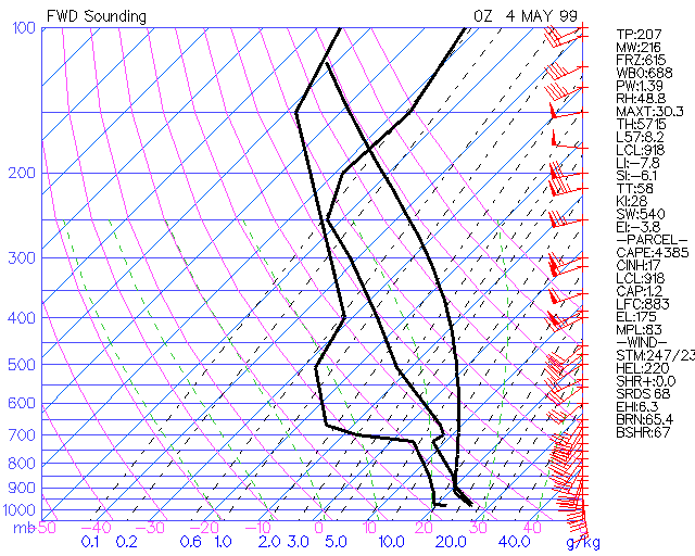
The sounding is a view of the atmosphere, usually, if the balloon makes it which 99% of the time it does, we get to see what is happening way past past 30000 feet. The only problem with a sounding is, for example, it is released at the Brisbane airport so it does not cover a very large area. The sonde attached to the balloon reads all the vital info and then it is analysed and put into the form of the sounding. There we get the temperature, dew points, moisture levels cape,cap,CIN TotalTotals etc.etc
I am still trying to piece that all together and place that into the general weather thread for storms.
So the storm cast for Friday 7:00pm has pretty well fallen flat with the latest run. We could maybe get a shower here and there.
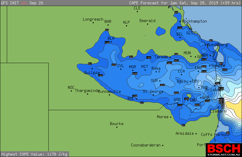
But for Saturday things have picked up a little bit on the positive side for a chance of storms if everything comes together. So I have used the 13:00 (1:00pm) here.
Figure 1 is the LI’s, they are not through the roof as in negative values but that doesn’t really matter, on a good storm day if they ever happen again


we will see readings of -5, -6, -7 etc.

Second figure is the cape. Once again not high values in the cape but still there is a chance
Figure 2.

Now the forecast sounding gives us a slice of the atmosphere, but this one is only a forecast sounding, on Saturday we really want to see the Soundings at 11:00. Most of us will look at Brisbane and other areas. Just on a side note, Moree doesn’t seem to have sounding lately, unless I have just been unlucky
Figure 3.

As you can see the LIs are -1.18. The cape is low at 207 j/kg. The cap is very low at 0.2°C. There is some moisture between 825mb and 700 mb.
There is a bit of instability by looking at the grey line. A small inversion at 650 mb but it doesn’t affect the cape or instability. Edit forgot the Total Totals is 52.8 which is isolated possible severe storms. It is close to 53 which is widely scattered possible severe storms. So we “could” see maybe a severe storm if everything pulls together. It is not the hard rule but a guideline with the chart used.
The sheers is good. All we need is small a trigger and they should fire off easily if everything comes together.
So going of this forecast sounding there is a possible chance of a storm around Brisbane and surrounding areas of SEQ tomorrow afternoon. Not over the top, but a possible chance. Some places maybe severe.
This figure of a sounding would have me running like mad. This is a full on storm so you will see the difference. It is called the loaded gun.


