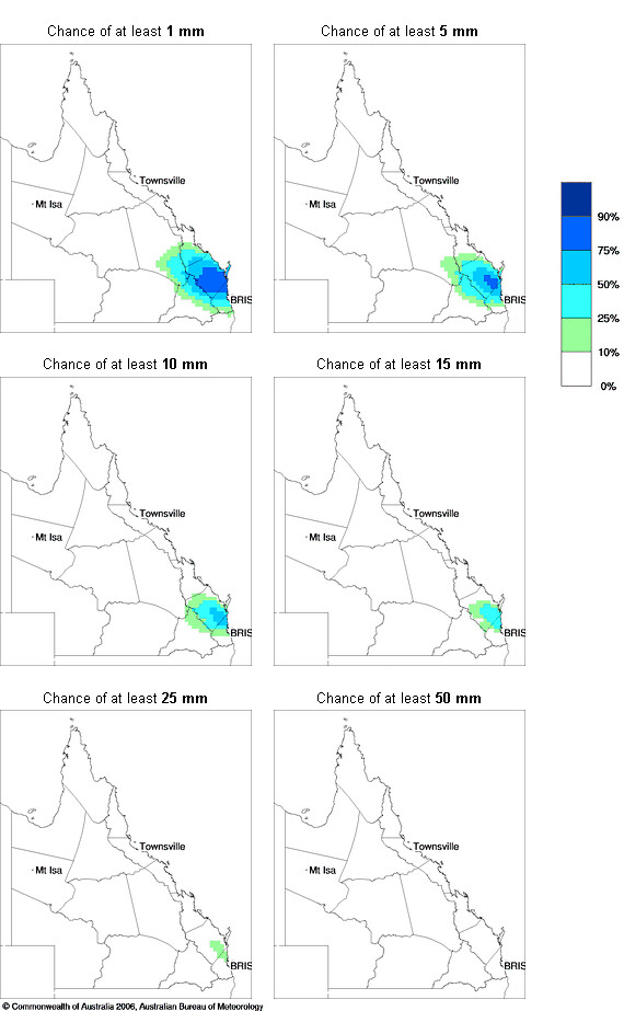
I think a surprisingly decent amount of rainfall could occur on Saturday for a number of locations in northern SE QLD/some sections of the WBB in particular.
The SE to E wind change that stabilised the air over SE QLD after Thursday stalls then gets pushed back down the coast by northerly winds while weakening.
This allows a more humid and unstable northerly flow to temporarily return to the region and combined with the nearby trough, causes showers, some thunderstorms, and possibly some rain areas to develop in northern and northwestern SE QLD (and the northeastern Downs, southern and western Wide Bay and Burnett, etc) before some of this activity spreads a bit further south during the day.
Most of this activity then progressively clears out of SE QLD on Saturday night.
Some lower lying areas which experience rainfall may also get rapid dense fog formation at night after the rainfall clears.
It doesn't look like the far southern Downs and Granite Belt are likely to get a lot out of this, if anything at all, while areas like the Sunshine Coast hinterlands are more favourable.
I've summarised what I think are some of the more notable differences from what we had on Thursday:
1). Activity likely to develop earlier than usual in northwestern and northern parts of SE QLD (perhaps as early as morning in some places), partly due to more moisture and earlier onset of instability.
2). Could be some decent rainfall amounts in a number of locations in northwestern and northern parts due to more moisture (naturally, some places won't do well and some will, depending on where the deeper convection is).
3). Although the main focus for the thunder and better rainfall is likely to be in those northwestern and northern parts, some other sections of SE QLD are also in with a shot for some shower or thunderstorm activity, particularly if the strong westerly steering winds aloft advect any inland storms towards the coast (but less locations are likely to be affected compared to further north).... or if activity spreads further south than expected.
4). More morning cloud cover in northern, northwestern, & central parts - this, together with earlier initiation makes the chance of severe storms in SE QLD less certain than Thursday but the possibility can't be ruled out yet for some locations due to good shear.
