Still looks to me like the majority of locations in our region will probably get some shower and/or storm action out of the setup on Monday (with some heavier falls for those who get storms), and perhaps also near or south of the border on Tuesday.... but there's still some uncertainties that warrant caution about extent/severity, namely if any morning cloud or precip on Monday from inland will affect things later on, and the very marginal setup on Tuesday as far as SE QLD goes.
Strong gusty W to SW winds developing on Tuesday during the middle of the day and afternoon especially about higher ground inland behind the front, as well as the strong southerlies about the islands and coastal fringe behind the coastal component of the change also.
Here’s how I think things will play out (I've mainly focused on SE QLD here since I haven't had much time to look at NE NSW in great detail) as a front, surface and a couple of upper troughs approach:
1️⃣ From late Sunday afternoon through the overnight hours, a band of showers/storms gradually makes its way across the Downs.
2️⃣ Monday morning has a bit of uncertainty about how little or much the inland activity reaches SE QLD.
A fair bit of cloud cover and some patchy decaying remains of the inland activity may reach the eastern Downs/some locations in SE QLD in the early morning hours ahead of the initial decaying upper trough, but you can never tell for sure with these things
(e.g. if inland steering winds aloft are strong enough, more extensive activity may reach SE QLD… conversely, if the remains weaken too early, they may struggle to even reach the eastern Downs or SE QLD, or it may be late morning even if they do at all).
3️⃣ Monday afternoon and night therefore also has a bit of uncertainty depending on what happens in point #2 above. The more favoured scenario is for a good band of showers/storms redeveloping inland before marching east into SE QLD in the afternoon or at night, although there’s a bit of a question mark over the timing/duration/extent of this activity. Some scenarios are as early as just after lunchtime while some delay it to the late night-time hours depending on location.
Although the majority of places currently look likely to get at least something out of this and a few locations may also get a severe storm (with intense rainfall, brief damaging winds, or large hail), the extent of storms as well as severe storms will depend on what happens in the morning.
If there’s more cloud cover and rainfall than expected in the morning, less locations are likely to be affected by a storm later on, and severe storms become less likely. On the other hand, if there’s less cloud cover and rainfall than expected, it only takes a few clearer gaps that last for a few hours to allow enough heating for numerous storms to develop, some severe (due to the strong shear and some turning in the lower levels near the coast with the NNE seabreeze effect).
4️⃣ Tuesday looks mainly dry north of the border but it still has a bit of uncertainty.
At this stage, the more favoured scenario is for the majority of any remaining overnight shower/storm activity to clear the area before dawn leaving most of the day dry (because a drier NW wind flow kicks in before becoming even drier W to SW winds during the middle of the day before the coastal change surges through)... with most of the activity confined to areas south of the border.
But if there’s more moisture than expected, there’s the slight risk of some additional (but more localised) shower or severe storm activity redeveloping, helped by the sharpening strong upper trough, strong shear and steering winds..... although even if this were to happen, it’d be mainly confined to southern parts of SE QLD and more likely near, and south of the QLD/NSW border. But if it’s too dry, nothing will form except for south of the border.
5️⃣ Strong gusty W to SW winds developing on Tuesday during the middle of the day and afternoon especially about higher ground inland behind the front, as well as the strong southerlies about the islands and coastal fringe behind the coastal component of the change also.
So basically looks like a case of a least something for most people unless you're unlucky... but due to the convective nature of the rainfall, some will probably get a lot while some won't.
Looking very hot later this week too, especially away from the coast with little or no rainfall after the upcoming activity.
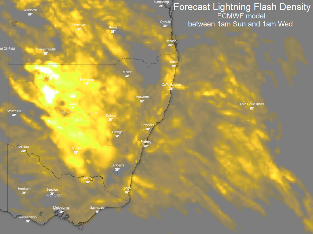
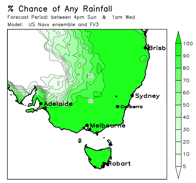
Above are some graphics (I'm not sure I'd treat that hole in the lightning activity on the first map too literally - depends a lot on how far east the initial inland activity can make it).
