Latest on Ex TC Uesi from BoM
TOP PRIORITY FOR IMMEDIATE BROADCAST
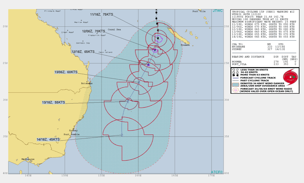
TROPICAL CYCLONE ADVICE NUMBER 13
Issued at 7:36 pm EST on Thursday 13 February 2020
Headline:
Ex-tropical cyclone Uesi continues to move south-southwest and is expected to cause destructive winds at Lord Howe Island during the night.
Areas Affected:
Warning Zone
Lord Howe Island.
Watch Zone
None.
Cancelled Zone
None.
Details of Ex-Tropical Cyclone Uesi at 7:00 pm AEST [8:00 pm LHDT]:
Intensity: Tropical Low, sustained winds near the centre of 95 kilometres per hour with wind gusts to 130 kilometres per hour.
Location: within 55 kilometres of 29.6 degrees South 160.5 degrees East, estimated to be 255 kilometres north northeast of Lord Howe Island.
Movement: south southwest at 30 kilometres per hour.
Ex-tropical cyclone Uesi continues to track in a south-southwest direction towards Lord Howe Island. It is likely to pass over the island or just to its east during the early hours of Friday morning.
Although the system has lost its tropical characteristics it is still expected to maintain an intensity equivalent to a category 2 tropical cyclone as it passes the island.
Hazards:
GALES with gusts in excess of 100 km/hr are now occurring about the Lord Howe Island and are likely to continue during the night.
DESTRUCTIVE easterly winds with gusts in excess of 125 km/hr should develop within the next several hours as the centre of ex-tropical cyclone Uesi approaches the island. There may be a period of lighter winds for a few hours during the night when the centre passes over the island, followed by sudden onset of DAMAGING winds from the opposite direction.
DAMAGING SURF CONDITIONS, with waves exceeding 5 metres in the surf zone, are likely to produce significant beach erosion. The sea water level may exceed the highest tide of the year. People living in coastal areas likely to be affected by this flooding should take measures to protect their property as much as possible.
Rain areas may become heavy at times, with possible flash floods during the night or tomorrow morning.
Strong and gusty winds are likely to persist about Lord Howe Island through till Saturday morning in the wake of the system moving well to the south of the island by the evening.
Recommended Action:
The NSW State Emergency Service advise you:
- The Community and Visitors to Lord Howe Island should stay calm and remain in a secure shelter - above the expected water level during the night or while the destructive winds continue.
- Do not venture outside when winds ease as this would be the centre of the low passing over. Destructive winds from a different direction could resume at any time.
- Heed the advice and follow the instructions of Police, Emergency Services personnel and local authorities.
For emergency help in floods and storms, ring the Lord Howe Island Police on [02] 6563 2199.