Soon to be "Gretel" has finally got a bit of shape.
https://earth.nullschool...phic=-214.19,-16.10,1106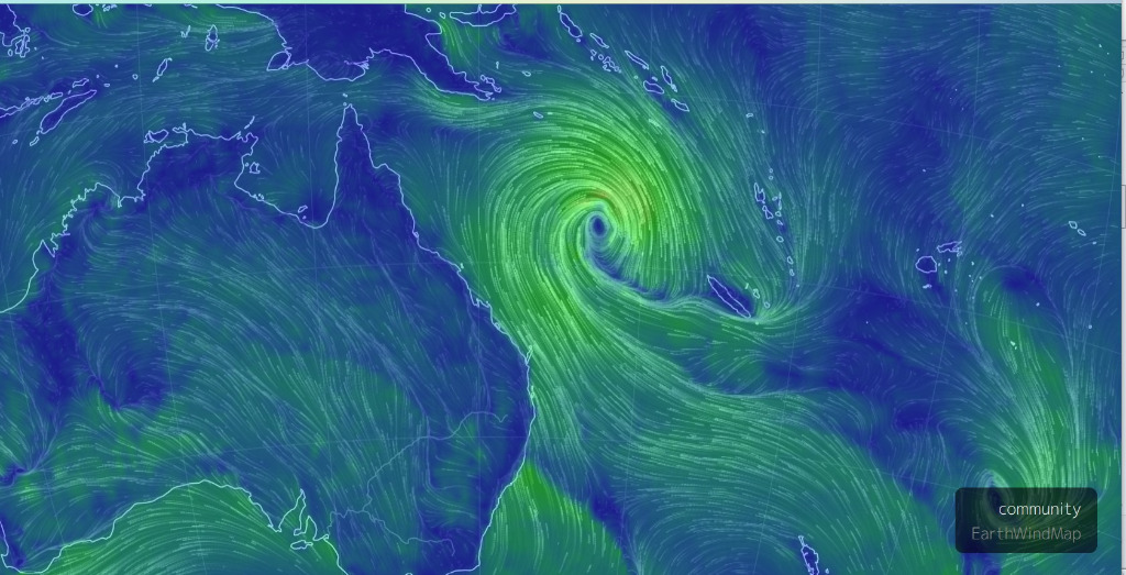 http://www.bom.gov.au/products/IDQ65002.shtml
 TROPICAL CYCLONE FORECAST TRACK MAP
Tropical Low
Issued at 5:05 pm AEST Saturday 14 March 2020. No Tropical Cyclone Advice is current for this system.

Headline:
Tropical cyclone expected to develop tonight and move further away from Queensland. The system is likely to impact Norfolk Island on Monday.
Areas affected:
Warning zone: None.
Watch zone: Norfolk Island.
Cancelled zones: None.
Details of Tropical Low at 4:00 pm AEST:
Intensity: tropical low, sustained winds near the centre of 55 kilometres per hour with wind gusts to 85 kilometres per hour.
Location: within 55 kilometres of 17.2 degrees South, 155.5 degrees East , 1830 kilometres northwest of Norfolk Island and 800 kilometres east northeast of Mackay .
Movement: east southeast at 23 kilometres per hour .
The tropical low in the Coral Sea continues to develop and move away from the Queensland coast. It is expected to develop into a tropical cyclone this evening.
The cyclone is likely to impact Norfolk Island on Monday, and although it may have lost some of its tropical characteristics by that time, it is expected to maintain an intensity equivalent to a category 2 tropical cyclone as it passes to the north of the island.
Hazards:
No direct impacts are expected about the Australian mainland.
DAMAGING WINDS, with peak gusts in excess of 90km/h are likely to develop about Norfolk Island in the early hours of Monday morning. DESTRUCTIVE WINDS, with gusts above 125 km/h are possible over the island during the day on Monday as the cyclone approaches and pases the island.
DAMAGING SURF CONDITIONS, with waves exceeding 5 metres in the surf zone, are likely to produce significant beach erosion.
Recommended Action:
For residents on Norfolk Island:
Check your property regularly for erosion or innundation by sea water, and if neccessary raise goods and electrical items.
Stay out of the water and stay well away from surf-exposed locations.
