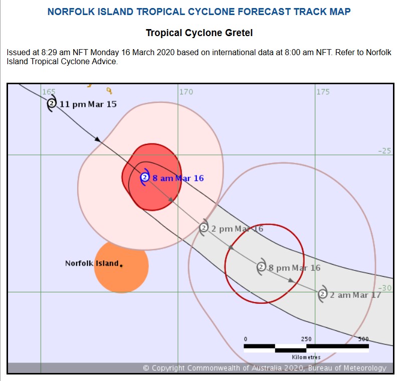
Tropical Cyclone Gretel
http://www.bom.gov.au/products/IDQ65253.shtml
Headline:
Tropical Cyclone Gretel is passing to the northeast of Norfolk Island.
Areas affected:
Warning zone: Norfolk Island.
Watch zone: None.
Cancelled zones: None.
Details of Tropical Cyclone Gretel at 8:00 am NFT:
Intensity: category 2, sustained winds near the centre of 100 kilometres per hour with wind gusts to 140 kilometres per hour.
Location: within 85 kilometres of 25.8 degrees South, 168.8 degrees East , 370 kilometres north northeast of Norfolk Island and 460 kilometres south southeast of Noumea .
Movement: southeast at 50 kilometres per hour .
Winds may increase today as Tropical Cyclone Gretel passes well to the northeast of Norfolk Island. Though the system is losing some of its tropical characteristics, it is anticipated to maintain winds equivalent to a category 2 system today. Winds at Norfolk Island are expected to begin easing during Monday evening.
Hazards:
DAMAGING WINDS, with sustained winds in excess of 60-70 km/h and peak gusts in excess of 90 km/h may develop about Norfolk Island, with winds most likely to peak in the early afternoon.
DESTRUCTIVE WINDS, with sustained winds in excess of 90 km/h and peak gusts above 125 km/h are possible over the island on Monday if the cyclone takes a more southerly track.
DAMAGING SURF CONDITIONS, with waves exceeding 5 metres in the surf zone, are likely to produce significant beach erosion.
HEAVY RAINFALL leading to flash flooding is a slight risk during this morning.
Recommended Action:
The Community and Visitors to Norfolk Island should finalise preparations and take shelter.
- Stay out of the water and stay well away from surf-exposed locations.
- Check your property for erosion or inundation by sea water, and if necessary raise goods and electrical items.
- Boats and outside property should be secured.
- Don't walk, ride your bicycle or drive through flood water, and keep clear of creeks and storm drains.
- Information is available from Emergency Management Norfolk Island (+6723 000) or the Norfolk Island Police Force (+6723 22222).
- For emergency assistance call Emergency Management Norfolk Island on +6723 000 (for assistance with storm damage, rising flood water, fallen trees on buildings or roof damage).
Details:
Time (NFT) Intensity Category Latitude
(decimal deg.) Longitude
(decimal deg.) Estimated Position
Accuracy (km)
0hr 8 am March 16 2 25.8S 168.8E 85
+6hr 2 pm March 16 2 27.6S 170.9E 95
+12hr 8 pm March 16 2 29.1S 173.1E 110
+18hr 2 am March 17 2 30.1S 175.3E 130
+24hr 8 am March 17 tropical low XXX XXX XXX
+36hr 8 pm March 17 tropical low XXX XXX XXX
+48hr 8 am March 18 tropical low XXX XXX XXX
+60hr 8 pm March 18 tropical low XXX XXX XXX
+72hr 8 am March 19 tropical low XXX XXX XXX
This warning is also available through TV and Radio broadcasts, the Bureau's website at
www.bom.gov.au or call 1300 659 210. The Bureau and Norfolk Island Emergency Services would appreciate this warning being broadcast regularly.
Norfolk Island Time = UTC + 11hrs
Australian Eastern Daylight Time = UTC + 11hrs
Australian Eastern Standard Time = UTC + 10hrs
Next Issue
The next Forecast Track Map will be issued by 12:00 pm NFT Monday

