 Ex-Tropical Cyclone Kirrily is currently located over the southwestern Gulf Country near the Northern Territory border, and is slowly moving to the south-southwest. The system will continue to track to the south close to the Queensland and Northern Territory border during the weekend. At this stage the system and its associated severe weather are expected to move through the North West district during today and into the Channel Country early Sunday morning, although some uncertainty remains with its exact track in the longer term. HEAVY RAINFALL which may lead to FLASH FLOODING is expected in western parts of the Gulf Country, North West and Channel Country districts. Six-hourly rainfall totals between 80 and 150 mm are likely, more likely near the Queensland and Northern Territory border. 24-hourly totals between 150 and 250 mm with isolated falls of 300mm are possible. Locally INTENSE RAINFALL which may lead to DANGEROUS AND LIFE-THREATENING FLASH FLOODING is also possible close to the low, particularly on the southern and western sides of the system. Isolated six-hourly totals between 150 and 200 mm are possible with 24-hourly totals exceeding 300 mm. A separate Severe Thunderstorm Warning will be issued if VERY DANGEROUS THUNDERSTORMS with INTENSE RAINFALL are detected. DAMAGING WIND GUSTS in excess of 90 km/h are also possible across the warning area, particularly associated with thunderstorms and heavy showers. A Flood Watch and several Flood Warnings are also current for the Central West, Channel Country and Gulf of Carpentaria catchments. See http://www.bom.gov.au/qld/warnings/ for more information. Locations which may be affected include Doomadgee, Camooweal, Urandangi, Gregory Downs Station, Westmoreland Station and Lawn Hill. Latest significant observations: 332 mm was observed at Westmoreland Station in 24 hours to 9 am Friday. 150 mm was observed at Mornington Island Airport in 24 hours to 9 am Friday. Gale force winds with a peak wind gust of 94 km/h recorded at Mornington Island Airport at 7:35 am Friday. 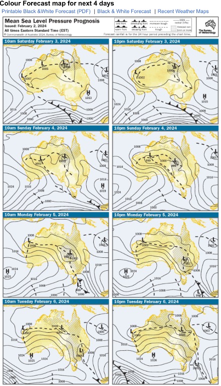
|


|
|
Font Color
Font Size
|
|
Important Information:
The Weather Forum uses cookies. By continuing to browse this site, you are agreeing to our use of cookies.
More Details
Close
