I posted a similar rundown elsewhere today but here's my thoughts on Tuesday's setup for the low-rainfall shower and gusty thunderstorm activity.
We're pretty close to the event now but I'm always a bit cautious since I find the northern end of such setups can often be touch and go, and only a slight downgrade can make a big difference for us.
I'm figuring the majority of locations that do get any activity will probably get less than 10mm (a lucky few may get more) in a short and sharp downpour with big fat raindrops... and of course, there's the dry lightning factor especially given the elevated fire dangers through Tuesday.
I think the most likely scenario will play out in this order:
1. A few inland afternoon showers/storms start firing up over higher ground mainly in the south (near the QLD/NSW border), the northern NSW tablelands, and possibly also in western parts of SEQ/far eastern Downs where the cap is weaker.
2. This activity rapidly moves eastwards on the strong westerly steering winds aloft.
3. The activity may become a bit more numerous as it get closer to the coast and encounters the seabreeze front and more moisture (but more stable air near the coast in the form of a cap makes this less than certain).
4. Later in the afternoon or early evening, this activity may eventually reach some sections of the coast as gusty low-rainfall high-based storms (some may try to develop some low level bases near the coast though) but if the cap is too strong near the coast, there is the risk these storms may die before reaching there.
Also, the chances of showers/storms get lower the further north you go (e.g. the Sunshine Coast has a lower risk but I still wouldn't rule out the possibility of activity reaching there yet).
It's a different story further south along the NSW coast though with rainfall amounts likely to be better there (some parts of the Hunter may even get moderate to locally heavy falls later Tuesday night, aided by the moist winds wrapping around a developing east coast low)..... but the southerly change pushing up the NSW MNC coast in the morning might be something to consider re any thunderstorm potential there.
The change creates a bit of a triple point in southwestern SE QLD as it clashes with the NNE'lies from the seabreeze effect and the drier inland westerlies although the change itself looks like stalling and washing out over southern SE QLD later.
ACCESS-C soundings look significantly drier overall than GFS soundings, at least at first, and both have a fair bit of capping in various areas (weaker around the ranges in the southwest) but 00z ACCESS-C does still try to fire up some low rainfall showers/storms mainly over higher ground in inland southern and western SE QLD and NE NSW before sweeping them in an ESE direction towards the coast very late afternoon/early evening.
Shear is good but moisture and capping takes a bit of an edge off the excitement.
Colder air aloft associated with the midlevel trough passing by to the south may help things a bit in southern parts as well as the right exit region of a jet streak producing upper divergence there.
EC suggests the band of mid and high cloud currently to our distant south may creep up to areas near the QLD/NSW border by the morning with sunnier conditions north of that.
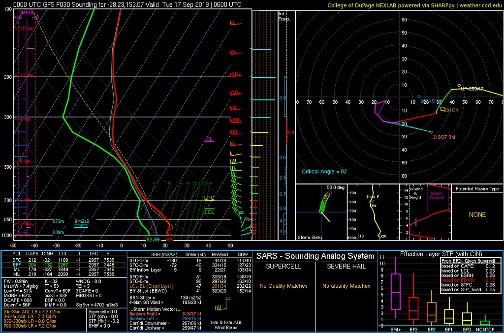
1st image above is a forecast GFS sounding for Darlington (around the border ranges region) for 4pm.
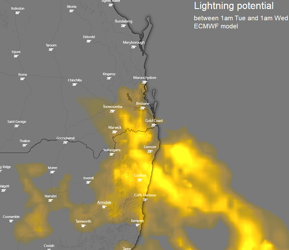
2nd image above is a map via Windy is a composite of multiple images of forecast lightning frequency from EC for the period covering 1am Tue to 1am Wed.
So not much useful rainfall and the prospect of dry gusty storms is a bit worrying... and majority of any afternoon/evening activity favouring inland southern parts... but still a chance elsewhere (northern parts with lower chances although not impossible).
