Weather Forum
»
Australia Weather
»
Far North Queensland
»
Far North Queensland - Day to Day Weather
Rank: Advanced Member
Groups: Registered
Joined: 9/01/2021(UTC)
Posts: 76
Location: Daintree
Thanks: 1 times
Was thanked: 52 time(s) in 42 post(s)
|
Kinda funny, Bunyip. Nice peaceful afternoon, night and morning and looking at the radar it has skirted us despite doom and gloom from media. However, the stream might be sagging lower plus nullschool shows a definite circular pattern that invariable tracks south.
Adding, as I type, sprinkles are starting...
|
|
|
|
|
|
Rank: Advanced Member
Groups: Registered
Joined: 12/02/2020(UTC) Posts: 788  Location: Daintree Thanks: 1301 times
Was thanked: 1087 time(s) in 610 post(s)
|
Well to be fair they did say from Sunday arvo for the good stuff to start.
Only 14mm here this morning. Glad I got the lawns done Friday arvo.
Looks like the Low is still a long way North.
What will the day bring ?
Cheers
|
|
|
|
|
|
|
Rank: Advanced Member
Groups: Registered
Joined: 12/02/2020(UTC) Posts: 427 Location: Cairns Was thanked: 820 time(s) in 349 post(s)
|
Apparently us FNQ residents are bracing for a tropical cyclone.......
There go the toilet paper stocks again
|
|
|
|
|
|
Rank: Advanced Member
Groups: Registered
Joined: 21/08/2019(UTC) Posts: 364 Location: Cairns Thanks: 249 times
Was thanked: 555 time(s) in 282 post(s)
|
Nice gusts at Arlington last night - 57knots. reports that it was possibly a waterspout.
Keep those pics coming @28, love the country out there in a good wet. |
Records for
2023: 2710mm
2024: 1884mm (no records April-Sept)
2025: 1859mm Jun: 15.4mm |
|
|
|
|
|
Rank: Advanced Member
Groups: Registered
Joined: 6/03/2020(UTC) Posts: 529 Thanks: 231 times
Was thanked: 1089 time(s) in 447 post(s)
|
So whats the go here..?
Bom says no way ..but JTWC says this...
1. FORMATION OF A SIGNIFICANT TROPICAL CYCLONE IS POSSIBLE WITHIN
A 210 NM RADIUS OF 14.8S 146.4E WITHIN THE NEXT 12 TO 24 HOURS.
AVAILABLE DATA DOES NOT JUSTIFY ISSUANCE OF NUMBERED TROPICAL
CYCLONE WARNINGS AT THIS TIME. WINDS IN THE AREA ARE ESTIMATED TO
BE 28 TO 33 KNOTS. METSAT IMAGERY AT 161800Z INDICATES THAT A
CIRCULATION CENTER IS LOCATED NEAR 14.8S 146.4E. THE SYSTEM IS
MOVING SOUTH-SOUTHWESTWARD AT 02 KNOTS.
2. REMARKS: THE AREA OF CONVECTION (INVEST 91P) PREVIOUSLY LOCATED
NEAR 14.4S 146.3E IS NOW LOCATED NEAR 14.8S 146.4E, APPROXIMATELY
133 NM NORTH-NORTHEAST OF CAIRNS, AUSTRALIA. ANIMATED MULTISPECTRAL
SATELLITE IMAGERY AND A 162042Z SSMIS 91GHZ MICROWAVE IMAGE REVEALS
CONVECTIVE BANDING WRAPPING INTO A WELL DEFINED, SMALL LOW LEVEL
CIRCULATION CENTER (LLCC) WITH FLARING CONVECTION IN THE WESTERN
PERIPHERY. A 161531Z AMSR2 WIND SPEED ESTIMATE REVEALS WINDS OF 28-
33 KNOTS ASSOCIATED WITH THE LLCC. INVEST 91P IS IN A FAVORABLE
ENVIRONMENT FOR TROPICAL DEVELOPMENT WITH GOOD SOUTHEASTWARD OUTFLOW
ALOFT, WEAK (5-10KT) VERTICAL WIND SHEAR, AND WARM (29-30C) SEA
SURFACE TEMPERATURES. GLOBAL MODELS SHOW LITTLE TO NO TROPICAL
DEVELOPMENT. HOWEVER, HISTORICALLY THE MODELS DO NOT HANDLE SYSTEMS
OF THIS SIZE WELL, THEREFORE CONFIDENCE IS MODEL GUIDANCE CURRENTLY
LOW. MAXIMUM SUSTAINED SURFACE WINDS ARE ESTIMATED AT 28 TO 33
KNOTS. MINIMUM SEA LEVEL PRESSURE IS ESTIMATED TO BE NEAR 998 MB.
THE POTENTIAL FOR THE DEVELOPMENT OF A SIGNIFICANT TROPICAL CYCLONE
WITHIN THE NEXT 24 HOURS IS HIGH.
|
 1 user thanked scott123 for this useful post.
|
|
|
|
Rank: Advanced Member
Groups: Registered
Joined: 12/02/2020(UTC) Posts: 427 Location: Cairns Was thanked: 820 time(s) in 349 post(s)
|
Well bugger me, T C Kimi, due to hit the coast as cat2 at 10:00 hrs tomorrow
|
1 user thanked Weary for this useful post.
|
|
|
|
Rank: Advanced Member
Groups: Registered
Joined: 12/02/2020(UTC) Posts: 427 Location: Cairns Was thanked: 820 time(s) in 349 post(s)
|
|
1 user thanked Weary for this useful post.
|
|
|
|
Rank: Advanced Member
Groups: Registered
Joined: 6/03/2020(UTC) Posts: 529 Thanks: 231 times
Was thanked: 1089 time(s) in 447 post(s)
|
Nice work BOM...not..!
Looks like it might get a bit squally for Bunyip and Dormant..
|
|
|
|
|
|
Rank: Advanced Member
Groups: Registered
Joined: 27/08/2019(UTC) Posts: 1,108 Location: various, Cairns temporarily Thanks: 2606 times
Was thanked: 889 time(s) in 518 post(s)
|
Originally Posted by: ronfishes  Keep those pics coming @28, love the country out there in a good wet. Thanks Ron. Nothing more interesting at the moment, but here's a pic I took just now of the sky to the north east. Just realised we've got Kimi turned up in the last couple hours. I did check earlier today but didn't see a hint. 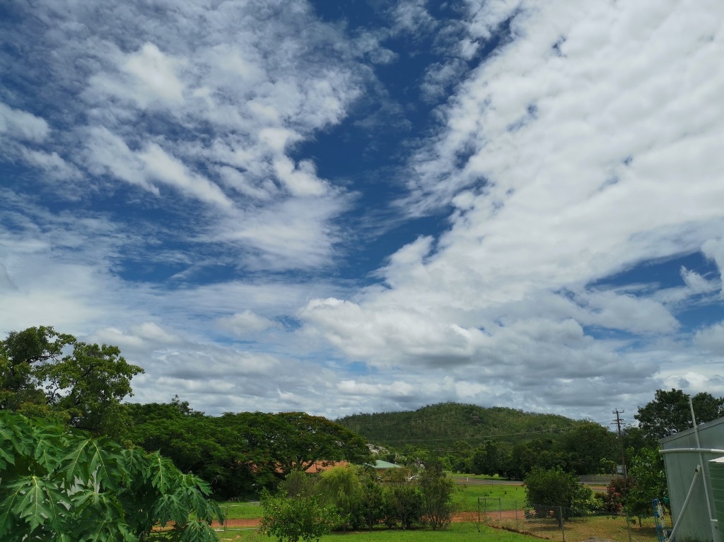 I better get in first and text the track to friends/family down south, so they don't panic with the media beatup, like last time. Edit: removed track, I'm a bit slow... Edited by user Sunday, 17 January 2021 12:43:04 PM(UTC)
| Reason: Not specified
|
|
|
|
|
|
Rank: Advanced Member
Groups: Registered
Joined: 12/02/2020(UTC) Posts: 427 Location: Cairns Was thanked: 820 time(s) in 349 post(s)
|
Originally Posted by: scott123 Nice work BOM...not..!
Looks like it might get a bit squally for Bunyip and Dormant.. Dunno about that Scott, given that the predicted crossing point from BOM usually moves south with every update I much prefer to have it south of me rather than north 
|
|
|
|
|
|
Rank: Advanced Member
Groups: Registered
Joined: 12/02/2020(UTC) Posts: 427 Location: Cairns Was thanked: 820 time(s) in 349 post(s)
|
|
1 user thanked Weary for this useful post.
|
|
|
|
Rank: Advanced Member
Groups: Registered
Joined: 12/02/2020(UTC) Posts: 427 Location: Cairns Was thanked: 820 time(s) in 349 post(s)
|
|
1 user thanked Weary for this useful post.
|
|
|
|
Rank: Advanced Member
Groups: Registered
Joined: 27/08/2019(UTC) Posts: 1,108 Location: various, Cairns temporarily Thanks: 2606 times
Was thanked: 889 time(s) in 518 post(s)
|
Originally Posted by: Weary Originally Posted by: scott123 Nice work BOM...not..!
Looks like it might get a bit squally for Bunyip and Dormant.. Dunno about that Scott, given that the predicted crossing point from BOM usually moves south with every update I much prefer to have it south of me rather than north Hmmmm.... This one could give Cairns a nice surprise. Out here we will just be grateful. The sky can change pretty quickly can't it. Better bring that stuff off the clothes line. Lol. 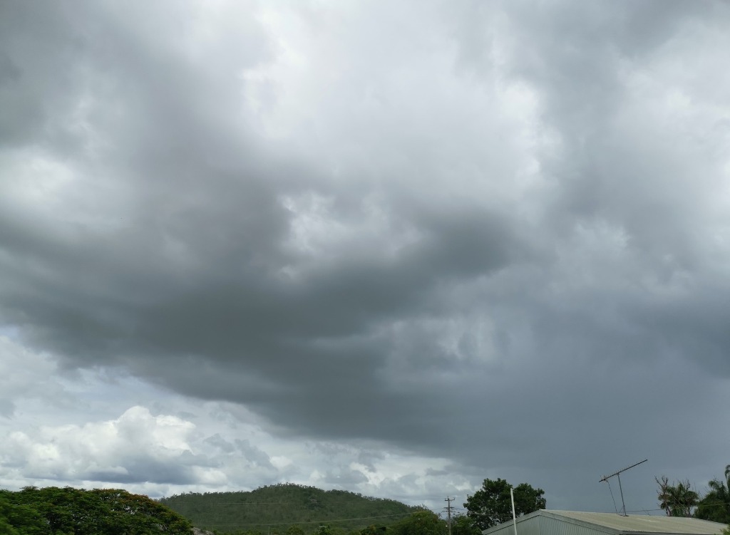
|
|
|
|
|
|
Rank: Advanced Member
Groups: Registered
Joined: 6/03/2020(UTC) Posts: 529 Thanks: 231 times
Was thanked: 1089 time(s) in 447 post(s)
|
Originally Posted by: Weary Originally Posted by: scott123 Nice work BOM...not..!
Looks like it might get a bit squally for Bunyip and Dormant.. Dunno about that Scott, given that the predicted crossing point from BOM usually moves south with every update I much prefer to have it south of me rather than north Be careful what you wish for mate...you might just cop a zinger right through your own backyard.. I certainly dont want it down here ..looks like just being a nuisance blow... 28, It looks so incredibly lush out there..the old council slasherman will certainly be busy.. Edited by user Sunday, 17 January 2021 1:52:05 PM(UTC)
| Reason: Not specified
|
|
|
|
|
|
Rank: Advanced Member
Groups: Registered
Joined: 12/02/2020(UTC) Posts: 427 Location: Cairns Was thanked: 820 time(s) in 349 post(s)
|
Trust me Scott, I don’t want it either.
BTW. Does anyone know where all the cyclone nerds have gone to so they can argue about the finer technical details online?
|
|
|
|
|
|
Rank: Advanced Member
Groups: Registered
Joined: 9/01/2021(UTC)
Posts: 76
Location: Daintree
Thanks: 1 times
Was thanked: 52 time(s) in 42 post(s)
|
Yes, Weary, just a slight twitch of the curve and it's down to Cairns. As you say, I'd never want to be south of one coming ashore. I only just came online and realise the presence of Kimi and sat thinking, what to do to prepare and really, I can't think of anything. Edited by user Sunday, 17 January 2021 2:25:18 PM(UTC)
| Reason: Not specified
|
|
|
|
|
|
Rank: Advanced Member
Groups: Registered
Joined: 6/03/2020(UTC) Posts: 529 Thanks: 231 times
Was thanked: 1089 time(s) in 447 post(s)
|
Apparently Kimi is a midget...with a "highly uncertain" track and intensity forecast..
Tropical Cyclone Kimi 2021
Last Modified: 03:00 January 17, 2021 UTC
Cyclone Kimi 2021Kimi 2021
Kimi is located 209 km (113 nautical miles) north-northeast of Cairns, Australia, and has tracked southward at 6 km/h (3 knots) over the past 6 hours.
Satellite imagery shows that Kimi has rapidly developed into a midget tropical cyclone over the previous few hours, with a very small core of deep cycling convection, hot towers with overshooting tops and clearly defined low-level banding outside of the cirrus shield.
The initial position is assessed with high confidence based on a combination of the outer edges of a circulation seen in animated radar data and analysis of a very fortuitous ASCAT-B scatterometer bullseye pass.
The system has developed very quickly in a very favourable environment characterised by low (5-10 knots) wind shear, warm (29-30°C) sea surface temperatures and due to its position under an upper-level ridge axis, dual channel moderate outflow aloft.
The general synoptic steering pattern is very complex, with two lobes of a deep-layer subtropical ridge, one to the north and another to the south, along with a weak upper-level low to the northwest combining to create a weak steering pattern, resulting in a slow track generally towards the south.
Over the next 24 to 36 hours the steering pattern will change subtly with the steering ridge to the east building and pushing west with a col region developing over eastern Australia.
In response to the overall shift in the steering pattern, Kimi should track slowly south then southwestward as the ridge strengthens, and after weakening over land, the system will fall under the influence of the low level easterly flow pushing it further inland to the west of Cairns.
The system is forecast to steadily intensify over the next 24 hours under favourable environmental conditions, reaching a peak of 110 km/h (60 knots) prior to landfall north of Cairns just after 36 hours.
After landfall, the system will quickly weaken and dissipate due to terrain interaction coupled with increasing wind shear. Dynamic model guidance is unsurprisingly in very poor agreement due to very small nature of the storm structure.
The model guidance presents a range of potential scenarios from a track due south then curving northward, to a due west track into the Gulf of Carpentaria.
The JTWC forecast track is a blend of the model guidance and is based primarily on analysis of the overall synoptic trend and does not favor any individual model tracker, thus lending very low confidence to the track forecast.
In light of the highly uncertain track forecast, confidence in the intensity forecast is subsequently very low as well. However the majority of the multi-model intensity consensus suggest intensification through landfall.
Maximum significant wave height at 17/00:00 UTC is 14 feet (4.3 meters). This cancels and supersedes Ref A (wtps21 PGTW 162230).
After landfall, the system will quickly weaken and dissipate due to terrain interaction coupled with increasing wind shear. Dynamic model guidance is unsurprisingly in very poor agreement due to very small nature of the storm structure.
The model guidance presents a range of potential scenarios from a track due south then curving northward, to a due west track into the Gulf of Carpentaria.
The JTWC forecast track is a blend of the model guidance and is based primarily on analysis of the overall synoptic trend and does not favor any individual model tracker, thus lending very low confidence to the track forecast.
In light of the highly uncertain track forecast, confidence in the intensity forecast is subsequently very low as well. However the majority of the multi-model intensity consensus suggest intensification through landfall.
Maximum significant wave height at 17/00:00 UTC is 14 feet (4.3 meters).
|
1 user thanked scott123 for this useful post.
|
|
|
|
Rank: Advanced Member
Groups: Registered
Joined: 21/08/2019(UTC) Posts: 364 Location: Cairns Thanks: 249 times
Was thanked: 555 time(s) in 282 post(s)
|
|
Records for
2023: 2710mm
2024: 1884mm (no records April-Sept)
2025: 1859mm Jun: 15.4mm |
1 user thanked ronfishes for this useful post.
|
|
|
|
Rank: Advanced Member
Groups: Registered
Joined: 12/02/2020(UTC) Posts: 788 Location: Daintree Thanks: 1301 times
Was thanked: 1087 time(s) in 610 post(s)
|
Yes it is going to be interesting.
These little ones can be fun though, just a bit of cleaning up after the event.
Yeah some nerds would be handy to watch the development with.
Cheers
|
|
1 user thanked FNQ Bunyip for this useful post.
|
|
|
|
Rank: Advanced Member
Groups: Registered
Joined: 12/02/2020(UTC) Posts: 427 Location: Cairns Was thanked: 820 time(s) in 349 post(s)
|
Creeping further south 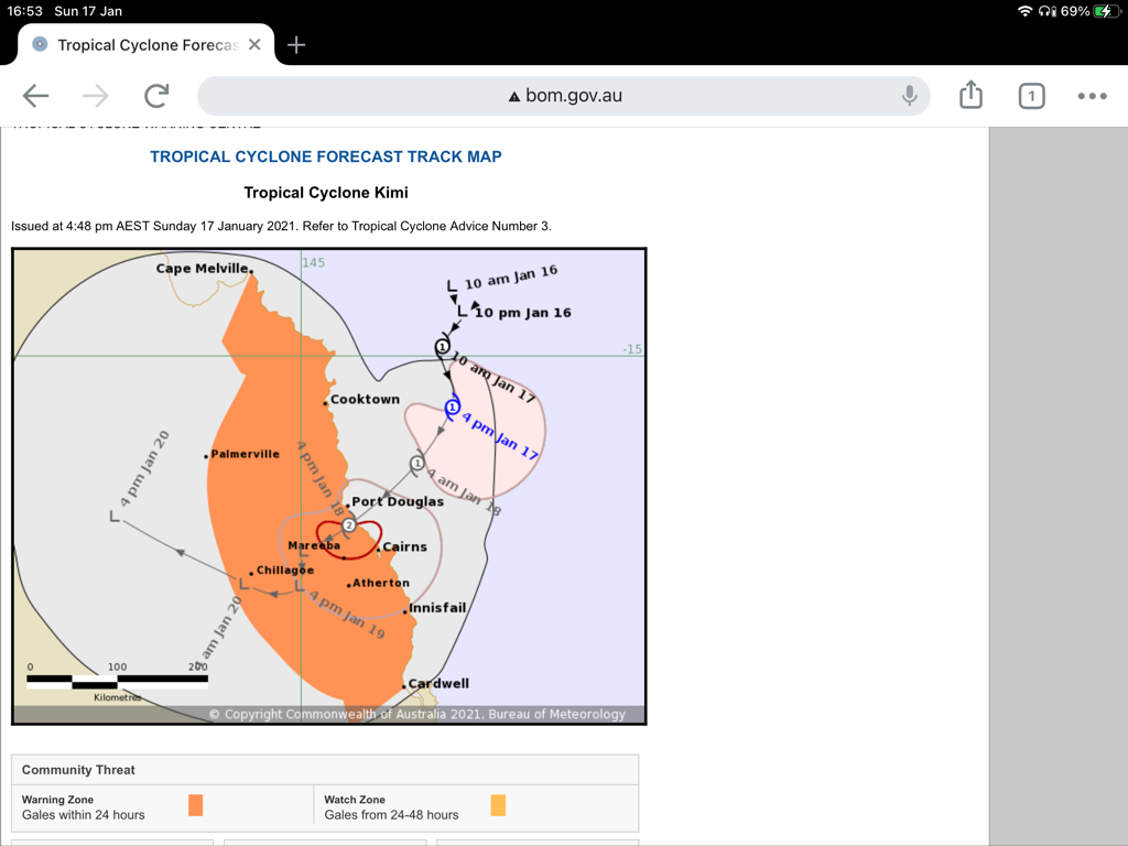
|
3 users thanked Weary for this useful post.
|
|
|
|
Weather Forum
»
Australia Weather
»
Far North Queensland
»
Far North Queensland - Day to Day Weather
Forum Jump
You cannot post new topics in this forum.
You cannot reply to topics in this forum.
You cannot delete your posts in this forum.
You cannot edit your posts in this forum.
You cannot create polls in this forum.
You cannot vote in polls in this forum.
Important Information:
The Weather Forum uses cookies. By continuing to browse this site, you are agreeing to our use of cookies.
More Details
Close
