Weather Forum
»
Australia Weather
»
South Australia
»
South Australia - Day to Day Weather
Rank: Advanced Member
Groups: Registered
Joined: 28/08/2019(UTC) Posts: 33  Location: southaustralia Thanks: 43 times
Was thanked: 28 time(s) in 18 post(s)
|
I am sure that rain band is still where it was this morning when l looked. I'll give you a few rain totals from the arid west region 24hrs up to 9am this morning. Nothing big at all but always exciting when the wet stuff falls out of the sky in this region. I mean look how many reporting stations in these arid regions . Just not enough population and they are Nullabor coast 1.4mm Penong on the coast 8.2 Ceduna coast 6.6mm Mobella inland SW of Cooper Pedy 1.8 mm. Thats there dose for the month. Commonweath station inland arid south of Cooper Pedy 2.8 mm thats a flood  . Over the allotment there. Tarcoola a nice drop of 5.6mm . Between cooperpedy and ceduna Yardea 6.4 mm SE Ceduna. Bit closer to the coast Oonadatta and Cooper Pedy. Zilch. Edited by user Friday, 20 September 2019 4:17:24 PM(UTC)
| Reason: Not specified
|
|
|
|
|
|
Rank: Member
Groups: Registered
Joined: 18/09/2019(UTC) Posts: 15 Location: Adelaide Thanks: 57 times
Was thanked: 30 time(s) in 13 post(s)
|
The rainband looks to be getting stronger. No lightning yet but the line and color suggest possible line forming? Nice link l found. Great graphics. Probably one of the best l have seen https://radar.ozforecast...au/stormtracker?radar=SATook a snap and reduced the size.I highly recommend looking at the animation in full size from the link above. Absolutely poetry in motion 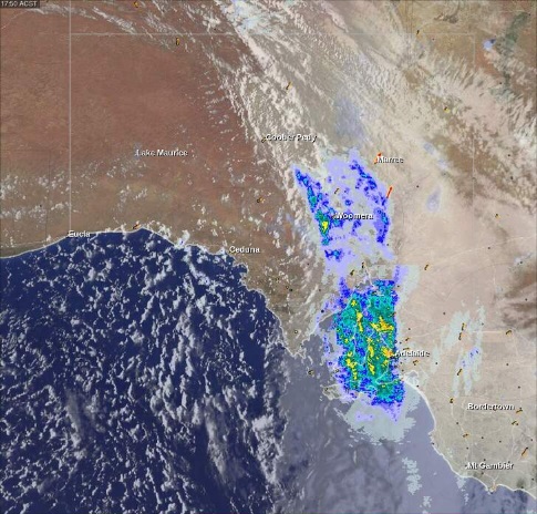
|
 1 user thanked squall19 for this useful post.
|
|
|
|
Rank: Member
Groups: Registered
Joined: 18/09/2019(UTC) Posts: 15 Location: Adelaide Thanks: 57 times
Was thanked: 30 time(s) in 13 post(s)
|
This rainband has been taking its time to pass through.No lightning so far.
totals so far from 9am to 8pm
Parawa west up to 17mm by 8pm
Kingscote 17.8mm
Cleve airport 21mm
Whyalla 14.8
Good road and gutter cleaning stuff.
|
1 user thanked squall19 for this useful post.
|
|
|
|
Rank: Member
Groups: Registered
Joined: 18/09/2019(UTC) Posts: 15 Location: Adelaide Thanks: 57 times
Was thanked: 30 time(s) in 13 post(s)
|
|
1 user thanked squall19 for this useful post.
|
|
|
|
Rank: Member
Groups: Registered
Joined: 18/09/2019(UTC) Posts: 15 Location: Adelaide Thanks: 57 times
Was thanked: 30 time(s) in 13 post(s)
|
The onshore flow from the Bight adding to the spring rain totals
The past 24 hrs.

|
1 user thanked squall19 for this useful post.
|
|
|
|
Rank: Advanced Member
Groups: Registered
Joined: 28/08/2019(UTC) Posts: 33 Location: southaustralia Thanks: 43 times
Was thanked: 28 time(s) in 18 post(s)
|
That high pressure cell is sure driving in some colder air. CooberPedy topped 21 today at 3.45pm and the feels like temperature is only 12.4 deg c at the moment.Winds about 30 and gusty
Woomera only made 18.8 and feels like 10 with the brisk wind
Nothing over 22 for the NW pastoral tomorrow
|
1 user thanked southawk for this useful post.
|
|
|
|
Rank: Advanced Member
Groups: Registered
Joined: 28/08/2019(UTC) Posts: 33 Location: southaustralia Thanks: 43 times
Was thanked: 28 time(s) in 18 post(s)
|
Woomera has a good set of long records for this region
Opened in 1949 . The average temperature for Woomera in September is 22.7 deg c.Might go close to average this month
I was amazed to read that the record maximum temp for September was 38.6 in 2012.
Not much happening here. A low of 9 tonight and a comfortable 28 tomorrow.Sunny and warm and dry right across the state.
|
1 user thanked southawk for this useful post.
|
|
|
|
Rank: Member
Groups: Registered
Joined: 18/09/2019(UTC) Posts: 15 Location: Adelaide Thanks: 57 times
Was thanked: 30 time(s) in 13 post(s)
|
Adelaide maximums for the next couple of days
Sunday 17 deg c
Monday 21 deg c
and
finally a welcome warm Tuesday 27deg c. Whoo Hooo
BOM have a frost warning our for the far SE corner of the state.
Frost Warning for the Mid North, Riverland and Murraylands forecast districts Issued at 2:45 pm CST on Saturday 28 September 2019. Please be aware Temperatures at ground level can be many degrees lower than those recorded by standard weather stations, especially in calm conditions with clear skies. Frosts with temperatures down to 0 degrees are forecast for Sunday morning in parts of the Mid North, Riverland and Murraylands forecast districtsEdited by user Saturday, 28 September 2019 7:13:22 PM(UTC)
| Reason: Not specified
|
2 users thanked squall19 for this useful post.
|
|
|
|
Rank: Advanced Member
Groups: Registered
Joined: 28/08/2019(UTC) Posts: 33 Location: southaustralia Thanks: 43 times
Was thanked: 28 time(s) in 18 post(s)
|
CooberPedy maxed out at 34.5 today. Didn't cool down overnignt. Minimum temp this morning was 29.5
Tomorrow. Nullabor 38, Oak Valley 41, Adelaide 29,,Murray Bridge 28, Robe 20
She's a warming up.
|
|
|
|
|
|
Rank: Advanced Member
Groups: Registered
Joined: 24/08/2019(UTC) Posts: 292 Location: Country Victorian Thanks: 580 times
Was thanked: 503 time(s) in 194 post(s)
|
ACC g has a weak precip' signal for SE SA on Saturday evening of the 5th Oct 2019
It is from the northern flank of a westerly belt low.
ACCESS wants to give most of the goods the next day to Victoria on Sunday the 6th.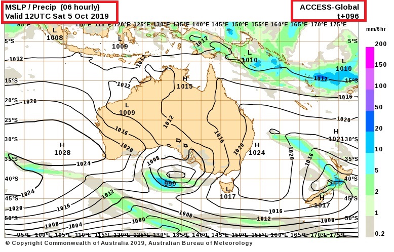
|
1 user thanked crikey for this useful post.
|
|
|
|
Rank: Advanced Member
Groups: Registered
Joined: 28/08/2019(UTC) Posts: 33 Location: southaustralia Thanks: 43 times
Was thanked: 28 time(s) in 18 post(s)
|
Looks like the slim possibility of NW pastoral could get some showers on the weekend and other areas of SA.
BOM model hopeful but not on the official forecast yet?
|
|
|
|
|
|
Rank: Member
Groups: Registered
Joined: 18/09/2019(UTC) Posts: 15 Location: Adelaide Thanks: 57 times
Was thanked: 30 time(s) in 13 post(s)
|
Weather in Adelaide has been quite boring. However,Tomorrow and Wednesday the chance of rain.
BOM 80% chance of rain
1-3mm tuesday and 2-6mm wednesday. Nice and refreshing.
Still not very warm Between 17and 23 deg c this week .
|
2 users thanked squall19 for this useful post.
|
|
|
|
Rank: Advanced Member
Groups: Registered
Joined: 24/08/2019(UTC) Posts: 292 Location: Country Victorian Thanks: 580 times
Was thanked: 503 time(s) in 194 post(s)
|
|
1 user thanked crikey for this useful post.
|
|
|
|
Rank: Advanced Member
Groups: Registered
Joined: 28/08/2019(UTC) Posts: 33 Location: southaustralia Thanks: 43 times
Was thanked: 28 time(s) in 18 post(s)
|
Some very hot maximums in South Australia today. Temperatures in all areas in the high 30's and quite a few around 39,40. The highest l could find was Tarcoola at 42 deg c Hows this. Pressure down to 998hPa in Port Lincoln when temperature maxed at 39.1 deg c I am hearing on the radio some temperatures may have been close to or were records? some maxims from the observations today Port Augusta 41.3 Remnark 39.1 Kadina 38.9 Edinburgh 38.5 Adelaide airport 35.9 http://www.bom.gov.au/sa...ions/saall.shtml?ref=hdr
|
|
|
|
|
|
Rank: Advanced Member
Groups: Registered
Joined: 24/08/2019(UTC) Posts: 292 Location: Country Victorian Thanks: 580 times
Was thanked: 503 time(s) in 194 post(s)
|
Some sub tropical moisture advecting down from the NT via the Alice on Monday the 25th Jan 2021. I believe this low passing by SA is the ex tropical from WA low transitioning south. Looks like good moisture available. Many will be Looking forward to this. 
|
|
|
|
|
|
Rank: Advanced Member
Groups: Registered
Joined: 26/08/2019(UTC) Posts: 50 Location: Perth Thanks: 74 times
Was thanked: 56 time(s) in 20 post(s)
|
Adelaide forecast ahead of the change and approaching trough is 41 deg c tomorrow. Very hot. BOM reckon the change will arrive late afternoon. Only giving Adelaide 8 mm on Monday. Hope they do better http://www.bom.gov.au/sa...s/adelaide.shtml?ref=hdrEdit Flood warning out for the NW 80-10mm possible Edited by user Saturday, 23 January 2021 4:39:33 PM(UTC)
| Reason: Not specified
|
|
|
|
|
|
Rank: Advanced Member
Groups: Registered
Joined: 26/08/2019(UTC) Posts: 122 Location: Travel but often NSW Thanks: 168 times
Was thanked: 90 time(s) in 53 post(s)
|
Some roaring hot temperatures in SA today ahead of a change. Palllamana in the Murraylands district hit 45.1 deg c at 2pm. So how’s the power grid holding up? Here is a snap of Adelaide region current temps’. Very very hot.🥵  Edited by user Sunday, 24 January 2021 2:39:11 PM(UTC)
| Reason: Not specified
|
|
|
|
|
|
Rank: Advanced Member
Groups: Registered
Joined: 24/08/2019(UTC) Posts: 292 Location: Country Victorian Thanks: 580 times
Was thanked: 503 time(s) in 194 post(s)
|
It’s 5pm in Adelaide and its still 41 deg c !
Wind change line can’t be far away . Wind still NNW currently.
|
|
|
|
|
|
Weather Forum
»
Australia Weather
»
South Australia
»
South Australia - Day to Day Weather
Forum Jump
You cannot post new topics in this forum.
You cannot reply to topics in this forum.
You cannot delete your posts in this forum.
You cannot edit your posts in this forum.
You cannot create polls in this forum.
You cannot vote in polls in this forum.
Important Information:
The Weather Forum uses cookies. By continuing to browse this site, you are agreeing to our use of cookies.
More Details
Close
