Weather Forum
»
Australia Weather
»
Victoria
»
Victoria - Day to Day Weather
Rank: Advanced Member
Groups: Registered
Joined: 26/08/2019(UTC) Posts: 122  Location: Travel but often NSW Thanks: 168 times
Was thanked: 90 time(s) in 53 post(s)
|
|
|
|
|
|
|
Rank: Newbie
Groups: Registered
Joined: 22/08/2019(UTC) Posts: 2 Location: Woodend VIC 579 ASL Was thanked: 2 time(s) in 1 post(s)
|
Interesting day with broad trough and boundaries within due to showers and storms. Good day to be home with radar and a good view of the sky.
|
 2 users thanked Ruckle for this useful post.
|
|
|
|
Rank: Advanced Member
Groups: Registered
Joined: 24/08/2019(UTC) Posts: 292 Location: Country Victorian Thanks: 580 times
Was thanked: 503 time(s) in 194 post(s)
|
Hi Ruckle. Great to have someone posting from VIC 😍 I am a part timer in VIC. I visit our old property near Maryborough a few times a year. So l take an interest in weather especially in the central west of the state. I like to see if the water tank is filling The news said wild storms in the SW on saturday. Yesterday. Weatherzone reporting on that event. Some significant hail and Warrnambool had 47mm . Here is the report with an ice pic’ as well http://m.weatherzone.com.au/news/533213
|
|
|
|
|
|
Rank: Advanced Member
Groups: Registered
Joined: 24/08/2019(UTC) Posts: 292 Location: Country Victorian Thanks: 580 times
Was thanked: 503 time(s) in 194 post(s)
|
Very large 1033 h pa in the BightThe southern flank reaches into the antartic and is bring up cold polar air behind today’s cold front. Wind change line has arrived at Mt Buller with current temp at 6.30pm at 2.6 deg c. Westerly. Shouldn’t be too long before they get a dusting. Radar showing some coldies with precip’ http://www.bom.gov.au/fwo/IDY65100.pdfMelbourne airport 13 deg c at 7 pm with the ‘big bash’ about to start at the MCG Edited by user Friday, 15 January 2021 6:15:46 PM(UTC)
| Reason: Not specified
|
|
|
|
|
|
Rank: Advanced Member
Groups: Registered
Joined: 24/08/2019(UTC) Posts: 292 Location: Country Victorian Thanks: 580 times
Was thanked: 503 time(s) in 194 post(s)
|
Hot NNW streaming over VIC ahead of a change around 5 am tomorrow morning. Australia Day. A nice relief for those enjoying a get together tomorrow. 1.30pm and it’s 41 in Shepparton. Around 38 deg c in Melbourne . Judging by the look of the rain band on the wind change line tomorrow morning. I suspect Australia Day will be heralded in by a line of thunderstorms. 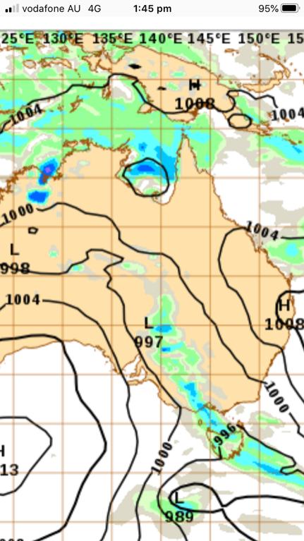
|
|
|
|
|
|
Rank: Advanced Member
Groups: Registered
Joined: 26/08/2019(UTC) Posts: 122 Location: Travel but often NSW Thanks: 168 times
Was thanked: 90 time(s) in 53 post(s)
|
Yarrawonga reached 42.3 and Melbourne airport 41 deg c
|
|
|
|
|
|
Rank: Advanced Member
Groups: Registered
Joined: 24/08/2019(UTC) Posts: 292 Location: Country Victorian Thanks: 580 times
Was thanked: 503 time(s) in 194 post(s)
|
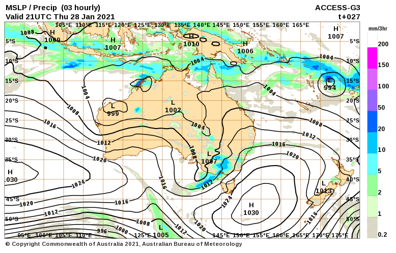 Nice rain/storm event for Victoria tomorrow. Has a tropical infeed from the Nw . So some humidity. The wide rain band sweeps over the west of the state sunrise tomorrow morning and intensifies during the morning as it moves eastward. The snap below is for 8 am where there appears to be a downpour in the central region http://www.bom.gov.au/au...harts/viewer/index.shtmlEdited by user Thursday, 28 January 2021 11:47:51 AM(UTC)
| Reason: Not specified
|
|
|
|
|
|
Rank: Advanced Member
Groups: Registered
Joined: 24/08/2019(UTC) Posts: 292 Location: Country Victorian Thanks: 580 times
Was thanked: 503 time(s) in 194 post(s)
|
Family down in Castlemaine Nth central reported a quick deluge which caused flooding in her business. Saw a picture on the news this morning of a pharmacy in Bendigo which had a lot of water damage. BOM 24 hr rainfall showing they had 30 mm so it must of all came quickly. Noticing that west central had much higher totals. 46 mm at Maryborough, Mount William grampians 68mm Tanks will be full. http://www.bom.gov.au/cg...rap_fwo.pl?IDV60003.html
|
|
|
|
|
|
Rank: Advanced Member
Groups: Registered
Joined: 26/08/2019(UTC) Posts: 122 Location: Travel but often NSW Thanks: 168 times
Was thanked: 90 time(s) in 53 post(s)
|
Looks like Victoria got hit again with some decent rain. I saw news reports of flooding. The BOM rainfall map shows widespread rain with central and North east areas copping the best. Mount Buffalo 134mm !🤩 
|
|
|
|
|
|
Rank: Advanced Member
Groups: Registered
Joined: 24/08/2019(UTC) Posts: 292 Location: Country Victorian Thanks: 580 times
Was thanked: 503 time(s) in 194 post(s)
|
We are down in west Victoria currently . We have a a mini heat wave . ( weather news terminology on TV)It has been hot and dry for the past 5 days. Weak trough has arrived with cloud to hopefully temper the temp’ today. We have had no Vodaphone for a week as Vodaphone has had problems with their provider. They have allowed free cancellation of our contract phone and all. Now with Telstra again and internet working fine. Possibility of a wet stormy event here this Friday with a tropical dip in isobars bring tropical moisture down as far as VIC. One to watch as giving eastern states chance of rain. 
|
|
|
|
|
|
Rank: Advanced Member
Groups: Registered
Joined: 24/08/2019(UTC) Posts: 292 Location: Country Victorian Thanks: 580 times
Was thanked: 503 time(s) in 194 post(s)
|
Finally a cool change has arrived after 6 days over 33 deg c here near Maryborough. Melbourne is expected to be in the low 20’s for the last week of summer. At bit further inland and BOM forecast has Maryborough max temps’ between 20 and 26 this working week. Noticing BOM forecast not showing rain event impacting Maryborough? this Friday. Will check ACCESS again tomorrow. Possible models not agreeing. http://www.bom.gov.au/vi...ecasts/maryborough.shtml
|
|
|
|
|
|
Rank: Advanced Member
Groups: Registered
Joined: 24/08/2019(UTC) Posts: 292 Location: Country Victorian Thanks: 580 times
Was thanked: 503 time(s) in 194 post(s)
|
|
|
|
|
|
|
Rank: Advanced Member
Groups: Registered
Joined: 24/08/2019(UTC) Posts: 292 Location: Country Victorian Thanks: 580 times
Was thanked: 503 time(s) in 194 post(s)
|
I hate the Victorian summer. Low humidity, dry in the west makes for hot and oven like. We are off the grid with no air con’ so the spray water bottle and breeze is our Savior.
Dew point at 5 deg c here at 5pm. Quite a brisk NE to assist the evaporative cooling
Access shows moisture from central Oz inland low moving to the SE this week but unfortunately looks to miss the west Vic.
Let’s see
|
|
|
|
|
|
Rank: Advanced Member
Groups: Registered
Joined: 24/08/2019(UTC) Posts: 292 Location: Country Victorian Thanks: 580 times
Was thanked: 503 time(s) in 194 post(s)
|
Ooooh! An upgrade for us in west Vic for the next 3 days . 70% chance of between 14 to 40 mm. Thunderstorms possible any time in the day. This will be a hit or miss the storm cloud event. We did well a few weeks ago from storms with 30 mm from 2 storms. I haven’t checked synoptic etc to explain why . but maybe tomorrow as l spy the radar, Amazing. This was not on the forecast yesterday? I can’t wait to be refreshed. The oven here today is criminal.🤪 Edited by user Tuesday, 25 January 2022 3:22:57 PM(UTC)
| Reason: Not specified
|
|
|
|
|
|
Rank: Advanced Member
Groups: Registered
Joined: 24/08/2019(UTC) Posts: 292 Location: Country Victorian Thanks: 580 times
Was thanked: 503 time(s) in 194 post(s)
|
According to BOM synoptic. Most of Australia is within a low pressure zone with a number of embedded lows scattered. West Victoria has an embedded low currently generating max’ diurnal thunderstorms. http://www.bom.gov.au/au...ptic_col_satellite.shtmlThey are moving from the west of the state toward the south. A NE feeding into one side of trough line and SW into the other side. This event is expected to last 3 days so l expect the trough line is stalling. Extensive storm lines in the west Vic currently at 3pm I reckon we should hear our first rumbles of thunder within the hour. Radar showing front line only 70 km away from our location. The NE ly has just started to crank
|
|
|
|
|
|
Rank: Advanced Member
Groups: Registered
Joined: 24/08/2019(UTC) Posts: 292 Location: Country Victorian Thanks: 580 times
Was thanked: 503 time(s) in 194 post(s)
|
Had a feast of storms yesterday arvo’ Scored 15mm from 2 that went right over us near Maryborough These storms migrated south and caused the usual damage to many towns including Melbourne suburbs Someone scored a direct hit on their house which caught fire and the occupants were taken to hospital Mildura had record One day January rainfall Details https://www.abc.net.au/n...bourne-and-vic/100784278Today trough line stalled near the SA border. Storms only starting to pop up now 3.30pm on radar The activity currently in the SW of the state. Might get the tail end by midnight but nothing like yesterday. Nice to have the rainbow radar installed now so that we can See what’s coming http://www.bom.gov.au/pr...s/IDR952.loop.shtml#skip
|
|
|
|
|
|
Rank: Advanced Member
Groups: Registered
Joined: 24/08/2019(UTC) Posts: 292 Location: Country Victorian Thanks: 580 times
Was thanked: 503 time(s) in 194 post(s)
|
The stalled trough out west finally moving away http://www.bom.gov.au/au...harts/synoptic_col.shtml6 mm yesterday with a storm and another 6mm today at Dunolly Radar says we may get another weaker band Wind change line arrived with everyone dropping down to about 22 deg. I am soo relieved . I hate the heat.
|
|
|
|
|
|
Rank: Advanced Member
Groups: Registered
Joined: 24/08/2019(UTC) Posts: 292 Location: Country Victorian Thanks: 580 times
Was thanked: 503 time(s) in 194 post(s)
|
Finally on our way touring and camping
A hot day at Tocumwal on the border but a nice swim in the Murray our Savior.
TheMurray is currently quite swollen atm no doubt fro the storm feat the past week or two or maybe they’re just released more water from the storage weirs
Very green in the NE with many paddocks flooded
The wind cranked at 2pm and late into the evening.
Very strong indeed but we missed the storms to our N NE.
|
|
|
|
|
|
Rank: Advanced Member
Groups: Registered
Joined: 24/08/2019(UTC) Posts: 292 Location: Country Victorian Thanks: 580 times
Was thanked: 503 time(s) in 194 post(s)
|
Arrived back in the goldfields yesterday to a warm balmy early Autumn. Temps’ in the high 20’s all week
.
Some thunderstorms in the west of the state currently 5.30pm
Currently we are in a storm free hole’. I wonder if we will escape tonight.
|
|
|
|
|
|
Weather Forum
»
Australia Weather
»
Victoria
»
Victoria - Day to Day Weather
Forum Jump
You cannot post new topics in this forum.
You cannot reply to topics in this forum.
You cannot delete your posts in this forum.
You cannot edit your posts in this forum.
You cannot create polls in this forum.
You cannot vote in polls in this forum.
Important Information:
The Weather Forum uses cookies. By continuing to browse this site, you are agreeing to our use of cookies.
More Details
Close
