Weather Forum
»
Australia Weather
»
SEQ and NE NSW
»
Storms, showers and heat Friday 22- 25 October 2021
Rank: Advanced Member
Groups: Registered, Administrators Joined: 21/08/2019(UTC) Posts: 941  Location: Brisbane Northside Thanks: 1198 times
Was thanked: 1136 time(s) in 674 post(s)
|
|
Colin Maitland. |
|
|
|
|
|
Rank: Advanced Member
Groups: Registered, Administrators Joined: 21/08/2019(UTC) Posts: 941 Location: Brisbane Northside Thanks: 1198 times
Was thanked: 1136 time(s) in 674 post(s)
|
Another er warning has been issued at 12:11 An incredible rain rate of 101mm in 1 hour at Luggage point. TOP PRIORITY FOR IMMEDIATE BROADCAST Severe Thunderstorm Warning - Southeast Queensland for DAMAGING WINDS, LARGE HAILSTONES and HEAVY RAINFALL For people in parts of Gold Coast Council Area. Issued at 12:13 pm Friday, 22 October 2021. 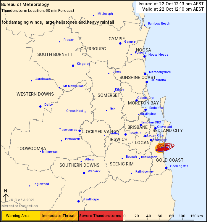 The Bureau of Meteorology warns that, at 12:10 pm, severe thunderstorms were detected on the weather radar near Hope Island, South Stradbroke Island and Coomera. These thunderstorms are slow moving. They are forecast to affect waters off South Stradbroke Island by 12:40 pm. Damaging winds, large hailstones and heavy rainfall that may lead to flash flooding are likely. 101mm was recorded in 1 hour at Luggage Point (Brisbane Airport) to 11:18pm |
Colin Maitland. |
|
|
|
|
|
Rank: Advanced Member
Groups: Registered, Administrators Joined: 21/08/2019(UTC) Posts: 941 Location: Brisbane Northside Thanks: 1198 times
Was thanked: 1136 time(s) in 674 post(s)
|
This was the previous STW issued prior to the 101 mm of rain that fell at Luggage Point The airport recorded 91 mm fall. Wind gust of 76 KM/H recorded in Moreton Bay.. For people in parts of Brisbane City Council Area. Issued at 10:19 am Friday, 22 October 2021. Isolated severe thunderstorm in eastern Brisbane, GIANT HAIL possible The Bureau of Meteorology warns that, at 10:15 am, very dangerous thunderstorms were detected on the weather radar near Wynnum, Brisbane Airport and Manly. These thunderstorms are moving towards the northeast. Very dangerous thunderstorms are forecast to affect Mud Island by 10:45 am and southern Moreton Island by 11:15 am. Large, possibly giant hailstones, damaging winds and heavy rainfall that may lead to flash flooding are likely. 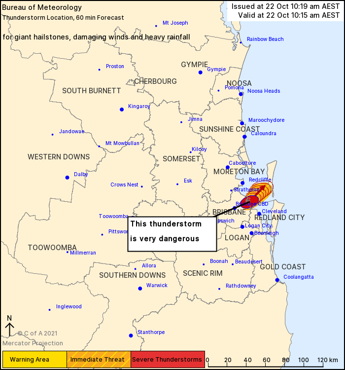 Edited by user Friday, 22 October 2021 12:32:08 PM(UTC)
| Reason: Not specified |
Colin Maitland. |
|
|
|
|
|
Rank: Advanced Member
Groups: Registered, Administrators Joined: 21/08/2019(UTC) Posts: 941 Location: Brisbane Northside Thanks: 1198 times
Was thanked: 1136 time(s) in 674 post(s)
|
BoM have confirmed a tornado at the airport as this mornings supercell passed over. It took the Bureau over an hour to investigate. 9 News wrote The Bureau of Meteorology (BoM) has confirmed a tornado touched down in Queensland after a severe storm warning was issued for Brisbane. The BoM said the funnel cloud was captured by a webcam at Brisbane Airport as a supercell thunderstorm swept through. 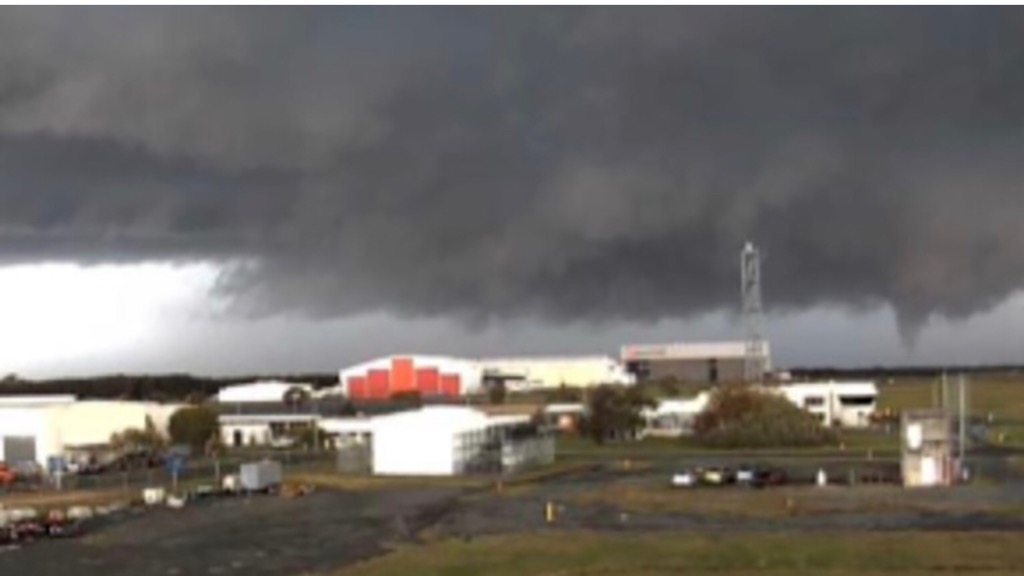  Edited by user Friday, 22 October 2021 1:06:09 PM(UTC)
| Reason: Not specified |
Colin Maitland. |
|
|
|
|
|
Rank: Advanced Member
Groups: Registered, Administrators Joined: 21/08/2019(UTC) Posts: 941 Location: Brisbane Northside Thanks: 1198 times
Was thanked: 1136 time(s) in 674 post(s)
|
 7 news report in regards to the intense supercell that struck the Brisbane Airport this morning. The storm cell hit about 11am on Friday, with video footage taken at the airport showing catering pods being blown around on the tarmac near a boarding gate. The Brisbane Airport Corporation said there was some damage, mainly centred on the international terminal. Flights were banned from taking off and landing and knock-on effects are expected to delay services for some time, a BAC spokeswoman told AAP. "We have teams assessing exactly what damage has happened. I've seen some video suggesting things on the apron have flown about," she said. "Certainly there's been some sort of sheeting or roofing that's come off. I don't know which building but it all seems to be around our international terminal." It's not yet clear if any aircraft have been damaged but no injuries have been reported. |
Colin Maitland. |
|
|
|
|
|
Rank: Advanced Member
Groups: Registered, Administrators Joined: 21/08/2019(UTC) Posts: 941 Location: Brisbane Northside Thanks: 1198 times
Was thanked: 1136 time(s) in 674 post(s)
|
Just observing 2 cells forming on the radar at 14:09. The cell near Maleny is looking quite nasty in the last few sweeps The cell to the west near Crows Nest has a fair bit of rotation within it. Just have to see what pans out.   |
Colin Maitland. |
|
|
|
|
|
Rank: Advanced Member
Groups: Registered, Administrators Joined: 21/08/2019(UTC) Posts: 941 Location: Brisbane Northside Thanks: 1198 times
Was thanked: 1136 time(s) in 674 post(s)
|
|
Colin Maitland. |
|
|
|
|
|
Rank: Advanced Member
Groups: Registered, Administrators Joined: 21/08/2019(UTC) Posts: 941 Location: Brisbane Northside Thanks: 1198 times
Was thanked: 1136 time(s) in 674 post(s)
|
Latest update  |
Colin Maitland. |
|
|
|
|
|
Rank: Advanced Member
Groups: Registered, Administrators Joined: 21/08/2019(UTC) Posts: 941 Location: Brisbane Northside Thanks: 1198 times
Was thanked: 1136 time(s) in 674 post(s)
|
|
Colin Maitland. |
|
|
|
|
|
Rank: Advanced Member
Groups: Registered, Administrators Joined: 21/08/2019(UTC) Posts: 941 Location: Brisbane Northside Thanks: 1198 times
Was thanked: 1136 time(s) in 674 post(s)
|
Latest update for STW from BoM 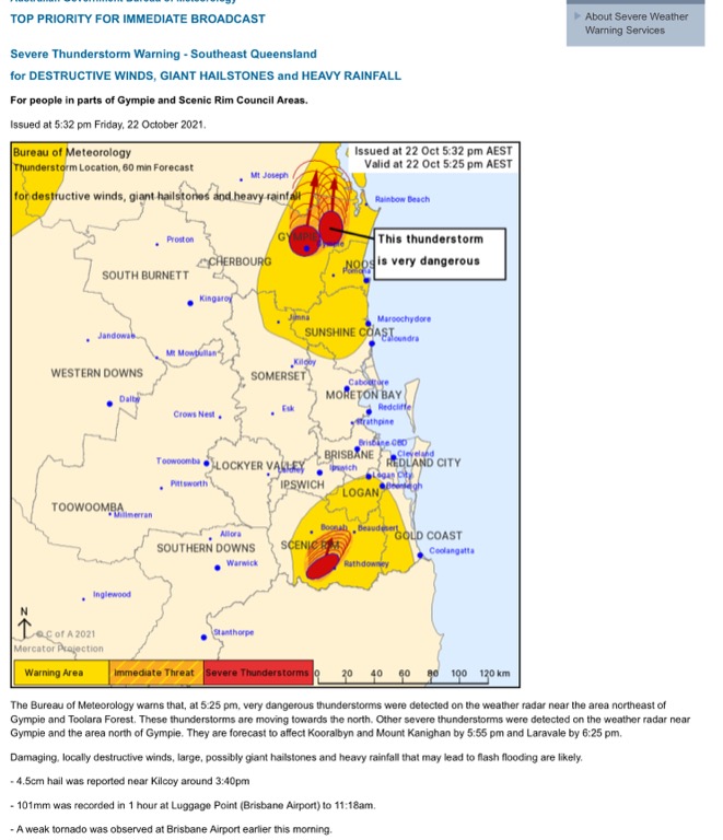 Tomorrow and Monday look like interesting days to keep an eye on. Sunday is going to be hot at this stage. |
Colin Maitland. |
|
|
|
|
|
Rank: Advanced Member
Groups: Registered, Administrators Joined: 21/08/2019(UTC) Posts: 941 Location: Brisbane Northside Thanks: 1198 times
Was thanked: 1136 time(s) in 674 post(s)
|
Slow moving storms this afternoon. STW out TOP PRIORITY FOR IMMEDIATE BROADCAST Severe Thunderstorm Warning - Southeast Queensland for DAMAGING WINDS and LARGE HAILSTONES For people in parts of Southern Downs and Toowoomba Council Areas. Issued at 4:27 pm Saturday, 23 October 2021. The Bureau of Meteorology warns that, at 4:20 pm, severe thunderstorms were detected on the weather radar near Leyburn and the area southwest of Warwick. These thunderstorms are moving towards the northeast to southeast. They are forecast to affect Stanthorpe, Applethorpe and Dalveen by 4:50 pm and Warwick, the area north of Warwick and Allora by 5:20 pm. Damaging winds and large hailstones are likely.    |
Colin Maitland. |
|
|
|
|
|
Rank: Advanced Member
Groups: Registered, Administrators Joined: 21/08/2019(UTC) Posts: 941 Location: Brisbane Northside Thanks: 1198 times
Was thanked: 1136 time(s) in 674 post(s)
|
STW TOP PRIORITY FOR IMMEDIATE BROADCAST Severe Thunderstorm Warning - Southeast Queensland for DAMAGING WINDS and LARGE HAILSTONES For people in Ipswich and parts of Logan, Somerset, Scenic Rim, Lockyer Valley and Brisbane City Council Areas. Issued at 6:11 pm Saturday, 23 October 2021. The Bureau of Meteorology warns that, at 6:05 pm, severe thunderstorms were detected on the weather radar near Grandchester. These thunderstorms are moving towards the east to southeast. They are forecast to affect Gatton, Rosewood and Helidon by 6:35 pm and Ipswich, Lowood and Fernvale by 7:05 pm. Damaging winds and large hailstones are likely.   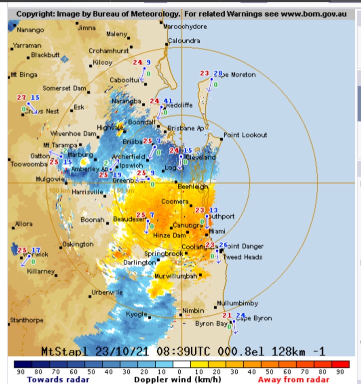 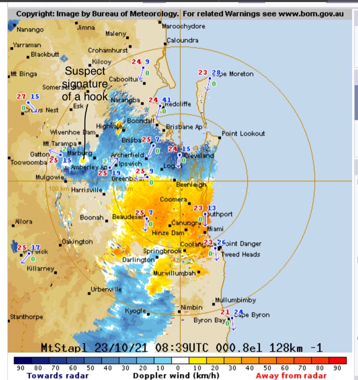 Edited by user Saturday, 23 October 2021 7:03:08 PM(UTC)
| Reason: Not specified |
Colin Maitland. |
|
|
|
|
|
Rank: Advanced Member
Groups: Registered, Administrators Joined: 21/08/2019(UTC) Posts: 941 Location: Brisbane Northside Thanks: 1198 times
Was thanked: 1136 time(s) in 674 post(s)
|
The warm Westerlies have kicked in and already and by 09:15 we have reached slightly over 31°C here at Lawnton.
It will be a hot day as the trough moves towards the east. Tomorrow an upper trough will approach the Southweatern parts of Queensland and once again cause unstable atmospheric conditions to build. This should produce a high chance of thunderstorms, possibly severe once again over NE NSW and SEQLD and up to Hervey Bay and surrounds. |
Colin Maitland. |
|
|
|
|
|
Rank: Advanced Member
Groups: Registered, Administrators Joined: 21/08/2019(UTC) Posts: 941 Location: Brisbane Northside Thanks: 1198 times
Was thanked: 1136 time(s) in 674 post(s)
|
Some of the very hot temps recorded by midday. I have included the sounding showing a very hot and dry atmosphere causing the heat. You can see how stable the atmosphere around the SouthEast thus the lack of storm potential. We should see a strong change come through late this afternoon/evening. A very strong Southeasterly change.  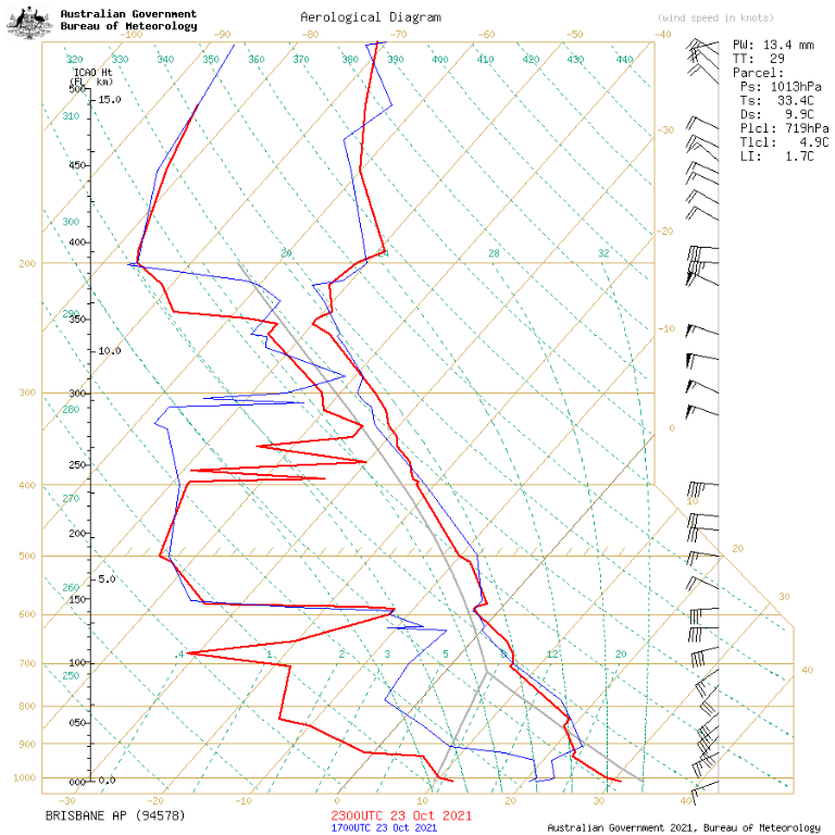 |
Colin Maitland. |
|
|
|
|
|
Rank: Advanced Member
Groups: Registered, Administrators Joined: 21/08/2019(UTC) Posts: 941 Location: Brisbane Northside Thanks: 1198 times
Was thanked: 1136 time(s) in 674 post(s)
|
Some of the hottest day recorded for October in some places today. I have highlighted the max. temps for today around the SEQ.  |
Colin Maitland. |
|
|
|
|
|
Rank: Advanced Member
Groups: Registered, Administrators Joined: 21/08/2019(UTC) Posts: 941 Location: Brisbane Northside Thanks: 1198 times
Was thanked: 1136 time(s) in 674 post(s)
|
Just checking youtube for any updates new videos of Friday’s tornado There are 3 news ones that have been uploaded |
Colin Maitland. |
|
|
|
|
|
Rank: Advanced Member
Groups: Registered, Administrators Joined: 21/08/2019(UTC) Posts: 941 Location: Brisbane Northside Thanks: 1198 times
Was thanked: 1136 time(s) in 674 post(s)
|
Unfortunately I don’t have the time to write a full breakdown for Monday. But it is a little bit of a mixed bag. Not a real clear cut storm set up. SkewT have plus and minuses for storms and charts are suggesting storms are more favourable to the North from Hervey Bay up to St Lawrence. I think from looking at the satellite and charts that for the SEQ area we will see some thunder showers or embedded storms. It is heating up very quickly. There is still the possibility of severe storms in some areas. The 11:00 sounding will give us a better idea but I wouldn’t be surprised we could see showers/ storms before that,   |
Colin Maitland. |
|
|
|
|
|
Rank: Advanced Member
Groups: Registered, Administrators Joined: 21/08/2019(UTC) Posts: 941 Location: Brisbane Northside Thanks: 1198 times
Was thanked: 1136 time(s) in 674 post(s)
|
A nice band of showers moving in. Maybe a few rumbles could be mixed in there too. 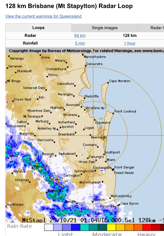  |
Colin Maitland. |
|
|
|
|
|
Rank: Advanced Member
Groups: Registered, Administrators Joined: 21/08/2019(UTC) Posts: 941 Location: Brisbane Northside Thanks: 1198 times
Was thanked: 1136 time(s) in 674 post(s)
|
Some good wind gusts getting picked up on the My Stapy Doppler 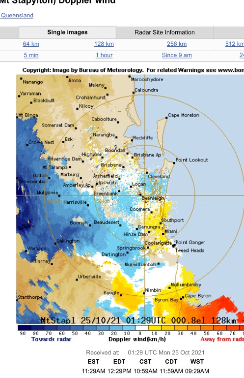 |
Colin Maitland. |
|
|
|
|
|
Rank: Advanced Member
Groups: Registered, Administrators Joined: 21/08/2019(UTC) Posts: 941 Location: Brisbane Northside Thanks: 1198 times
Was thanked: 1136 time(s) in 674 post(s)
|
STW has been issued mainly for a severe cell on the Sunshine Coast. TOP PRIORITY FOR IMMEDIATE BROADCAST Severe Thunderstorm Warning - Southeast Queensland for DAMAGING WINDS and LARGE HAILSTONES For people in parts of Gympie, Somerset and Sunshine Coast Council Areas. Issued at 12:14 pm Monday, 25 October 2021. The Bureau of Meteorology warns that, at 12:00 pm, severe thunderstorms were detected on the weather radar. Thunderstorms are moving towards the east. They are forecast to affect Borumba Dam by 12:30 pm and Kenilworth by 1:00 pm. Damaging winds and large hailstones are likely.  Edited by user Monday, 25 October 2021 12:41:59 PM(UTC)
| Reason: Picture was cramped |
Colin Maitland. |
|
|
|
|
|
Weather Forum
»
Australia Weather
»
SEQ and NE NSW
»
Storms, showers and heat Friday 22- 25 October 2021
Forum Jump
You cannot post new topics in this forum.
You cannot reply to topics in this forum.
You cannot delete your posts in this forum.
You cannot edit your posts in this forum.
You cannot create polls in this forum.
You cannot vote in polls in this forum.
Important Information:
The Weather Forum uses cookies. By continuing to browse this site, you are agreeing to our use of cookies.
More Details
Close
