Weather Forum
»
Australia Weather
»
SEQ and NE NSW
»
SE QLD and NE NSW - Day to day Weather 2025
Rank: Advanced Member
Groups: Registered, Administrators Joined: 21/08/2019(UTC) Posts: 942  Location: Brisbane Northside Thanks: 1198 times
Was thanked: 1136 time(s) in 674 post(s)
|
Hi everyone, Another year so a new thread has been opened so we can post about weather events that happen during 2025. Everyone is welcome to join in. Edited by user Wednesday, 1 January 2025 11:52:59 AM(UTC)
| Reason: Not specified |
Colin Maitland. |
 1 user thanked Colmait for this useful post.
|
|
|
|
Rank: Advanced Member
Groups: Registered, Administrators Joined: 21/08/2019(UTC) Posts: 942 Location: Brisbane Northside Thanks: 1198 times
Was thanked: 1136 time(s) in 674 post(s)
|
It became quite humid very quickly around 1945 here in the Northern Brisbane outskirts. There is a rain band moving down from the North West which should reach the Northern areas of Brisbane at least if not further. There are warnings out for heavy rainfalls to the North as per below. 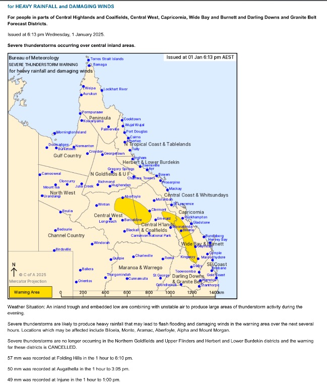 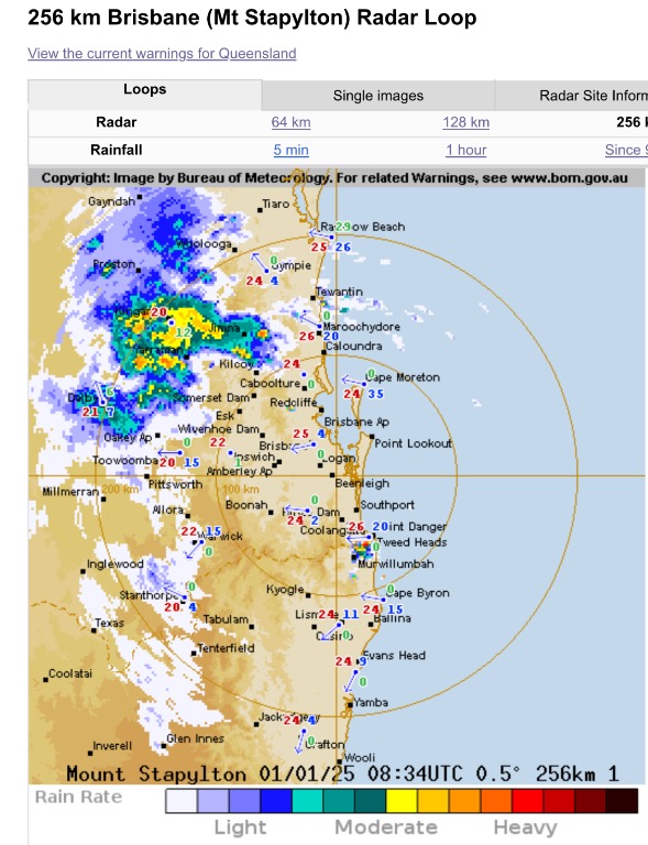 |
Colin Maitland. |
1 user thanked Colmait for this useful post.
|
|
|
|
Rank: Advanced Member
Groups: Registered, Administrators Joined: 21/08/2019(UTC) Posts: 942 Location: Brisbane Northside Thanks: 1198 times
Was thanked: 1136 time(s) in 674 post(s)
|
|
Colin Maitland. |
1 user thanked Colmait for this useful post.
|
|
|
|
Rank: Advanced Member
Groups: Registered, Administrators Joined: 21/08/2019(UTC) Posts: 942 Location: Brisbane Northside Thanks: 1198 times
Was thanked: 1136 time(s) in 674 post(s)
|
We have a week of showers to look forward to. No big totals have been forecast as such. Most models are predicting up to 25 mm over the next 7 days. But as can be the case some areas could experience greater falls if you happen to get under a good downpour that may develop. This is WATL ( Australian Digital Forecast Database model) 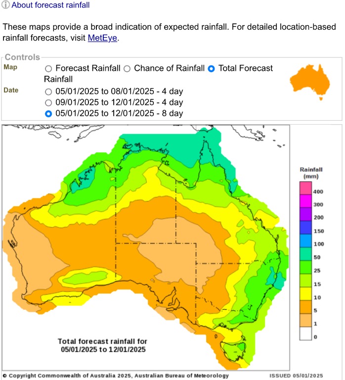 |
Colin Maitland. |
1 user thanked Colmait for this useful post.
|
|
|
|
Rank: Advanced Member
Groups: Registered, Administrators Joined: 21/08/2019(UTC) Posts: 942 Location: Brisbane Northside Thanks: 1198 times
Was thanked: 1136 time(s) in 674 post(s)
|
Storms popping up again with STW issued. We should see storms over the next 5 or so days. The models have been hinting at the possibility of storms increasing from Thursday onwards. This afternoons/evening possibility was an outside chance but it has managed to come through and dropping some good rain totals. So please keep an eye and ear open for any warnings issued over the next few days. On another note it looks like we are going to move into a summer La Niña event according to all the criteria’s that BoM set for such an event to be declared. Technically NOAA and other agencies have a slightly lower target range and have declared a La Niña event has started. But in the meantime here is this evenings STW.    |
Colin Maitland. |
1 user thanked Colmait for this useful post.
|
|
|
|
Rank: Advanced Member
Groups: Registered, Administrators Joined: 21/08/2019(UTC) Posts: 942 Location: Brisbane Northside Thanks: 1198 times
Was thanked: 1136 time(s) in 674 post(s)
|
|
Colin Maitland. |
1 user thanked Colmait for this useful post.
|
|
|
|
Rank: Advanced Member
Groups: Registered, Administrators Joined: 21/08/2019(UTC) Posts: 942 Location: Brisbane Northside Thanks: 1198 times
Was thanked: 1136 time(s) in 674 post(s)
|
Latest STW for Wednesday 8 Jan 2025 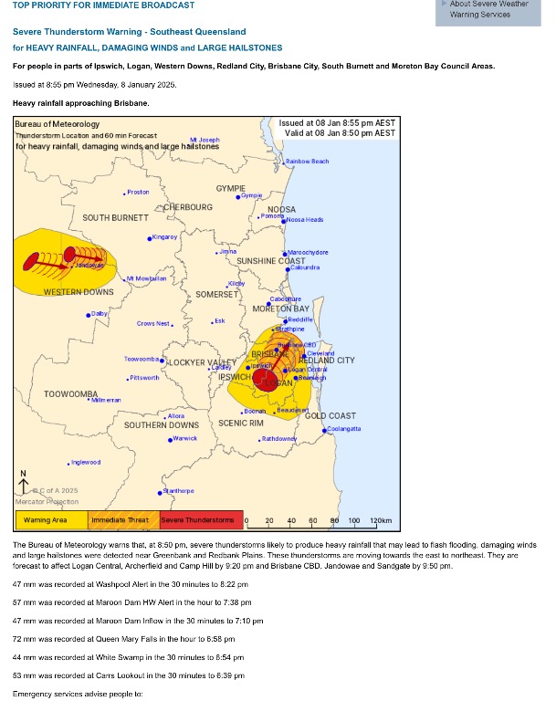  |
Colin Maitland. |
1 user thanked Colmait for this useful post.
|
|
|
|
Rank: Advanced Member
Groups: Registered, Administrators Joined: 21/08/2019(UTC) Posts: 942 Location: Brisbane Northside Thanks: 1198 times
Was thanked: 1136 time(s) in 674 post(s)
|
Latest STW. Heavy rainfall has fallen with the slow moving cells. 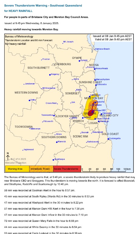 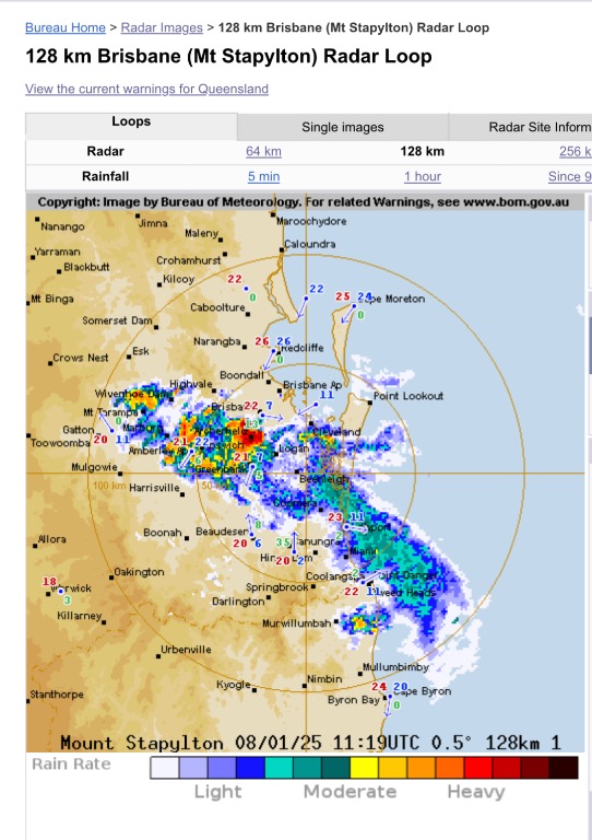 |
Colin Maitland. |
1 user thanked Colmait for this useful post.
|
|
|
|
Rank: Advanced Member
Groups: Registered, Administrators Joined: 21/08/2019(UTC) Posts: 942 Location: Brisbane Northside Thanks: 1198 times
Was thanked: 1136 time(s) in 674 post(s)
|
Last night, storms hit Lawnton just before 22:30 and we had 44 mm in 20 minutes. As for today, showers and storm cells are just going to keep popping up on the radar with the atmosphere being so primed. There is a lot of instability right through this thread area which is quite a big area. So please be vigilant as some of these cells could become severe and very quickly. Below is this mornings sounding from Brisbane and the instability is very prominent. 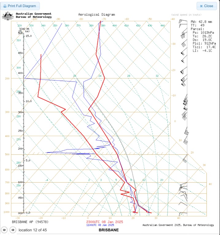  |
Colin Maitland. |
1 user thanked Colmait for this useful post.
|
|
|
|
Rank: Advanced Member
Groups: Registered, Administrators Joined: 21/08/2019(UTC) Posts: 942 Location: Brisbane Northside Thanks: 1198 times
Was thanked: 1136 time(s) in 674 post(s)
|
Latest STW 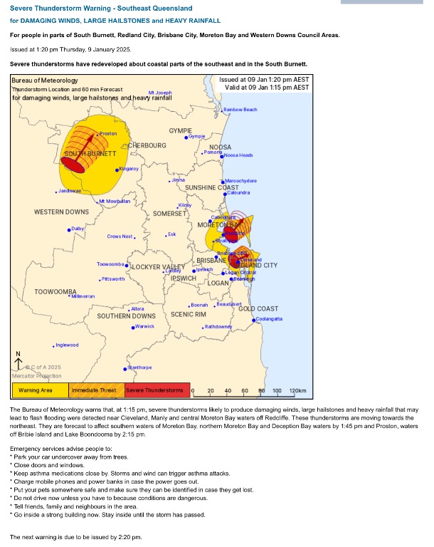 |
Colin Maitland. |
1 user thanked Colmait for this useful post.
|
|
|
|
Rank: Advanced Member
Groups: Registered, Administrators Joined: 21/08/2019(UTC) Posts: 942 Location: Brisbane Northside Thanks: 1198 times
Was thanked: 1136 time(s) in 674 post(s)
|
I wouldn’t be surprised if there are a couple of water spouts etc out over the Bay this afternoon. Pretty nasty cells as they are moving to the East passing over the Coastline. Latest STW, Doppler and radar image at 13:58.  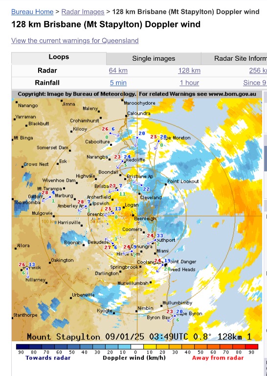  |
Colin Maitland. |
1 user thanked Colmait for this useful post.
|
|
|
|
Rank: Advanced Member
Groups: Registered, Administrators Joined: 21/08/2019(UTC) Posts: 942 Location: Brisbane Northside Thanks: 1198 times
Was thanked: 1136 time(s) in 674 post(s)
|
Small cells still popping up on the radar. Also the latest STW   |
Colin Maitland. |
1 user thanked Colmait for this useful post.
|
|
|
|
Rank: Advanced Member
Groups: Registered, Administrators Joined: 21/08/2019(UTC) Posts: 942 Location: Brisbane Northside Thanks: 1198 times
Was thanked: 1136 time(s) in 674 post(s)
|
|
Colin Maitland. |
2 users thanked Colmait for this useful post.
|
|
|
|
Rank: Advanced Member
Groups: Registered, Administrators Joined: 21/08/2019(UTC) Posts: 942 Location: Brisbane Northside Thanks: 1198 times
Was thanked: 1136 time(s) in 674 post(s)
|
Latest STW  |
Colin Maitland. |
1 user thanked Colmait for this useful post.
|
|
|
|
Rank: Advanced Member
Groups: Registered, Administrators Joined: 21/08/2019(UTC) Posts: 942 Location: Brisbane Northside Thanks: 1198 times
Was thanked: 1136 time(s) in 674 post(s)
|
The latest STW. Also a sweep of the current radar at 17:46. There is moisture around the metropolitan areas to the east of the warnings, so as the evening sets in, there maybe enough moisture from the NorthEasterlies to feed a few more storms or showers closer to the Metropolitan areas and to the North and South of Brisbane. Just have to see how it pans out. But more action is a very high possibility over the coming days. Please stay up to date with any warnings. 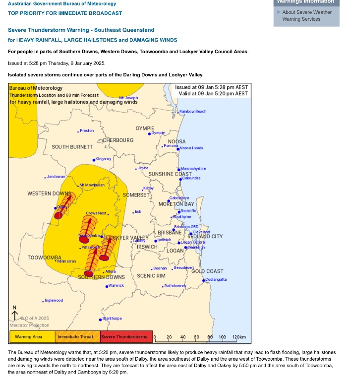 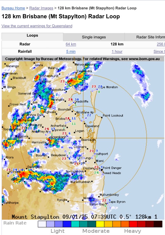 |
Colin Maitland. |
1 user thanked Colmait for this useful post.
|
|
|
|
Rank: Advanced Member
Groups: Registered, Administrators Joined: 21/08/2019(UTC) Posts: 942 Location: Brisbane Northside Thanks: 1198 times
Was thanked: 1136 time(s) in 674 post(s)
|
The latest STW and radar sweep. 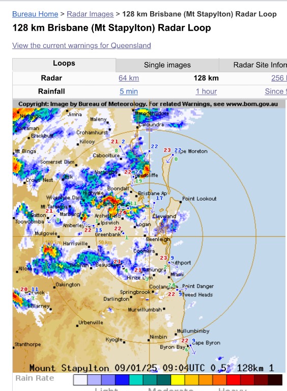  |
Colin Maitland. |
1 user thanked Colmait for this useful post.
|
|
|
|
Rank: Advanced Member
Groups: Registered, Administrators Joined: 21/08/2019(UTC) Posts: 942 Location: Brisbane Northside Thanks: 1198 times
Was thanked: 1136 time(s) in 674 post(s)
|
More storm warnings have been issued today. (Friday 10 Jan.25) At this stage the warnings are for areas west of the range and just below the range. There is an Easterly and North Easterly inflow into the storms so it is being feed with plenty of moisture. Keep an eye and ear open for any warnings throughout the the afternoon. I do feel these storms should reach further East than the warning zone currently is indicating.   |
Colin Maitland. |
1 user thanked Colmait for this useful post.
|
|
|
|
Rank: Advanced Member
Groups: Registered, Administrators Joined: 21/08/2019(UTC) Posts: 942 Location: Brisbane Northside Thanks: 1198 times
Was thanked: 1136 time(s) in 674 post(s)
|
After watching the radar during Thursday’s storms, I thought there may have been a possibility of some waterspouts as I posted yesterday. I was searching through some news sites and this came up from the Fraser Coast area. Theyre must have been a few in Moreton Bay and down towards Wynum as well  |
Colin Maitland. |
1 user thanked Colmait for this useful post.
|
|
|
|
Rank: Advanced Member
Groups: Registered, Administrators Joined: 21/08/2019(UTC) Posts: 942 Location: Brisbane Northside Thanks: 1198 times
Was thanked: 1136 time(s) in 674 post(s)
|
Latest STW. Also the 256K Mt Stapylton sweep and these storms are heading to the East. As the afternoon wears on and the Seabreeze becomes more prominent we should see more storms closer to the Coast.  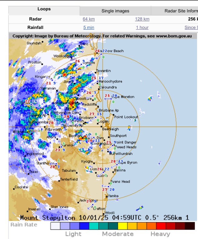 |
Colin Maitland. |
1 user thanked Colmait for this useful post.
|
|
|
|
Rank: Advanced Member
Groups: Registered, Administrators Joined: 21/08/2019(UTC) Posts: 942 Location: Brisbane Northside Thanks: 1198 times
Was thanked: 1136 time(s) in 674 post(s)
|
|
Colin Maitland. |
1 user thanked Colmait for this useful post.
|
|
|
|
Weather Forum
»
Australia Weather
»
SEQ and NE NSW
»
SE QLD and NE NSW - Day to day Weather 2025
Forum Jump
You cannot post new topics in this forum.
You cannot reply to topics in this forum.
You cannot delete your posts in this forum.
You cannot edit your posts in this forum.
You cannot create polls in this forum.
You cannot vote in polls in this forum.
Important Information:
The Weather Forum uses cookies. By continuing to browse this site, you are agreeing to our use of cookies.
More Details
Close
