Weather Forum
»
Australia Weather
»
SEQ and NE NSW
»
QLD trough and rain 26th Sep - 2nd Oct 2019
Rank: Advanced Member
Groups: Registered
Joined: 2/09/2019(UTC) Posts: 105  Location: Brisbane Thanks: 145 times
Was thanked: 561 time(s) in 103 post(s)
|
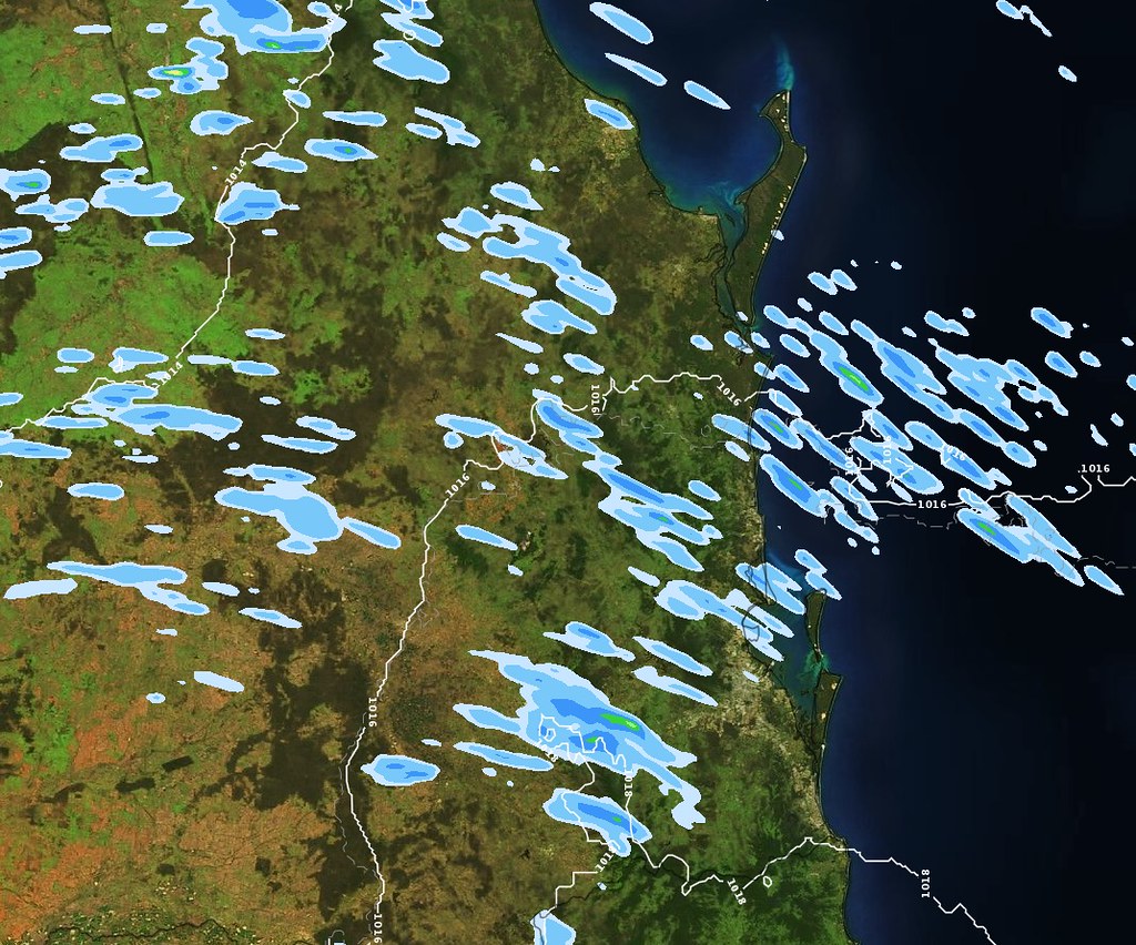 Originally Posted by: crikey  Yes.Thanks for that KEN. Makes sense. If l think back ACC R was only showing very light totals . I forget that models don't show thunderstorm out put and that is why we always say. 'could be higher totals under thunderstorms'  I have seen WATL do very well indeed with some of those big depressions. Anyway great to have something to watch and cheer for. Good luck today 'guys' with any amount of rain and storms  The majority of models have to parameterise (approximate) convection such as showers and thunderstorms but a few explicitly model individual convection such as ACCESS-C, HRRR (used in the US), etc and you can often see individual showers and storms in such models (see above example for 1hr accumulations from onshore showers in ACCESS-C) as well as convective features such as MCS's. You can also often see outflow boundaries from storms in EC due to its high resolution (about 9km).
|
 5 users thanked Ken for this useful post.
|
|
|
|
Rank: Advanced Member
Groups: Registered
Joined: 21/09/2019(UTC) Posts: 32 Location: Gold coast Thanks: 125 times
Was thanked: 126 time(s) in 31 post(s)
|
A Fabulous insight into the diagnosis of storm potential Colmait. What a treat on the forum this morning. I will look with interest today.
Only a few mm on the Gold Coast last night. In a few hours all signs of dampness will be gone. The foreshore grassed area on the coast is very dry and brown.
Mount Tamborine on the ranges had 6mm . Fire affected Canungra had 7mm. So that has to be good news from this troughing.
Lots of clear sky ahead of this potential event this afternoon here on the Gold coast. Good for convection in these circumstances l believe.
Thanks for your expert response KEN. Great stuff.
|
7 users thanked juztchillin for this useful post.
|
|
|
|
Rank: Advanced Member
Groups: Registered
Joined: 21/09/2019(UTC) Posts: 32 Location: Gold coast Thanks: 125 times
Was thanked: 126 time(s) in 31 post(s)
|
Originally Posted by: Ken
The majority of models have to parameterise (approximate) convection such as showers and thunderstorms but a few explicitly model individual convection such as ACCESS-C, HRRR (used in the US), etc and you can often see individual showers and storms in such models (see above example for 1hr accumulations from onshore showers in ACCESS-C) as well as convective features such as MCS's.
You can also often see outflow boundaries from storms in EC due to its high resolution (about 9km).
Just amazing what the models can achieve. Truly enlightening.  Thanks for that information
|
6 users thanked juztchillin for this useful post.
|
|
|
|
Rank: Member
Groups: Registered
Joined: 27/08/2019(UTC) Posts: 11 Location: Warwick, Queensland Thanks: 8 times
Was thanked: 60 time(s) in 11 post(s)
|
5.5mm yesterday and overnight here. About the same in the official gauge. We managed to avoid our driest September on record. Overall temps this month are near or slightly above average. Overall, a nice month temperature-wise.
|
5 users thanked WarwickEye2Sky for this useful post.
|
|
|
|
Rank: Advanced Member
Groups: Registered, Administrators Joined: 21/08/2019(UTC) Posts: 941 Location: Brisbane Northside Thanks: 1198 times
Was thanked: 1136 time(s) in 674 post(s)
|
Just had a look at the Brisbane Sounding, Moree is coming back up for me now too, it kept saying no sounding available for a few days in a row, and had a look at Charleville. They show a small chance of a storm. It has a few things making it a little harder to fire off but I will be keeping an eye on the radar. A little better than stormcast showed this morning. I am going out on a gut feeling, but not expecting much, it could easily fold. There is a little bit more moisture than the forecast soundings had. We could see a rumble or 2. Just with Brisbane there is not a lot of instability and a bit of capping but with the afternoon seabreeze it just might cause a few to pop up. Out west there is a bit more of chance. Still working on the big post. Doing it up on word so hopefully I can post it easily. Edited by user Friday, 27 September 2019 12:15:51 PM(UTC)
| Reason: Back on ipad. |
Colin Maitland. |
5 users thanked Colmait for this useful post.
|
|
|
|
Rank: Advanced Member
Groups: Registered
Joined: 21/08/2019(UTC) Posts: 185 Location: Ocean View Thanks: 359 times
Was thanked: 539 time(s) in 161 post(s)
|
Originally Posted by: Ken
The majority of models have to parameterise (approximate) convection such as showers and thunderstorms but a few explicitly model individual convection such as ACCESS-C, HRRR (used in the US), etc and you can often see individual showers and storms in such models (see above example for 1hr accumulations from onshore showers in ACCESS-C) as well as convective features such as MCS's.
You can also often see outflow boundaries from storms in EC due to its high resolution (about 9km).
Hi Ken, Is EC data publicly available or is it restricted commercial data?
|
4 users thanked Pabloako for this useful post.
|
|
|
|
Rank: Advanced Member
Groups: Registered
Joined: 13/09/2019(UTC)
Posts: 118
Location: Caboolture (the next Las Vegas!)
Thanks: 215 times
Was thanked: 297 time(s) in 100 post(s)
|
There are a couple of small blobs starting to show up on the Brisbane radar and moving due east. 
|
4 users thanked DelBoy for this useful post.
|
|
|
|
Rank: Advanced Member
Groups: Registered
Joined: 3/09/2019(UTC) Posts: 51 Location: gladstone Thanks: 108 times
Was thanked: 50 time(s) in 26 post(s)
|
Interesting and educational stuff going on here as well as good reading. So good on ya all Comparing the synoptic and the cloud convection on the satellite picture.I have marked in green my interpretation of where another trough line is. The NW/SE line in SEQ and a line of cloud running N/S out west of the divide in NSW. On the national radar you can see the cumulus speckles emerging quite clearly in the QLD interior. Good luck with your chasing colmait.  
|
3 users thanked oceangyre for this useful post.
|
|
|
|
Rank: Advanced Member
Groups: Registered
Joined: 2/09/2019(UTC) Posts: 105 Location: Brisbane Thanks: 145 times
Was thanked: 561 time(s) in 103 post(s)
|
Originally Posted by: Pabloako Originally Posted by: Ken
The majority of models have to parameterise (approximate) convection such as showers and thunderstorms but a few explicitly model individual convection such as ACCESS-C, HRRR (used in the US), etc and you can often see individual showers and storms in such models (see above example for 1hr accumulations from onshore showers in ACCESS-C) as well as convective features such as MCS's.
You can also often see outflow boundaries from storms in EC due to its high resolution (about 9km).
Hi Ken, Is EC data publicly available or is it restricted commercial data? Many of more of its parameters are publicly available through 3rd party websites than they used to be. For example, windy.com or the Windy app will show EC data by default (unless you choose another applicable model for your region) with lots of parameters. Same with weather.us and some others. Some parameters are still only available through user pays websites or internally to national weather agencies though.
|
5 users thanked Ken for this useful post.
|
|
|
|
Rank: Advanced Member
Groups: Registered
Joined: 23/08/2019(UTC) Posts: 155 Location: Narangba Thanks: 280 times
Was thanked: 442 time(s) in 136 post(s)
|
Originally Posted by: WarwickEye2Sky 5.5mm yesterday and overnight here. About the same in the official gauge. We managed to avoid our driest September on record. Overall temps this month are near or slightly above average. Overall, a nice month temperature-wise. Great to hear that you got some rain in your area. Just enough to settle the dust and a tiny bit to soak in.
|
4 users thanked CantSpellNarangba for this useful post.
|
|
|
|
Rank: Advanced Member
Groups: Registered
Joined: 3/09/2019(UTC) Posts: 51 Location: gladstone Thanks: 108 times
Was thanked: 50 time(s) in 26 post(s)
|
Emerald radar
ROMA 11.6mm 
A couple of lines marching toward the coast.Not loaded yet 3pm Edited by user Friday, 27 September 2019 3:12:50 PM(UTC)
| Reason: Not specified
|
5 users thanked oceangyre for this useful post.
|
|
|
|
Rank: Advanced Member
Groups: Registered
Joined: 15/09/2019(UTC) Posts: 39 Location: Forster NSW mid coast Thanks: 172 times
Was thanked: 135 time(s) in 39 post(s)
|
|
4 users thanked i4hanish for this useful post.
|
|
|
|
Rank: Advanced Member
Groups: Registered
Joined: 24/08/2019(UTC) Posts: 292 Location: Country Victorian Thanks: 580 times
Was thanked: 503 time(s) in 194 post(s)
|
A storm cell about to go over Harrietville and on towards Coomera perhaps. There appears to be a general growth in activity in the region generally .http://www.bom.gov.au/products/IDR663.loop.shtmlThe WZ storm map is showing some 200hpa moisture stream pushing in behind those storms. Sourced from the Indian ocean.
That will either give them a boost, or shear their tops off?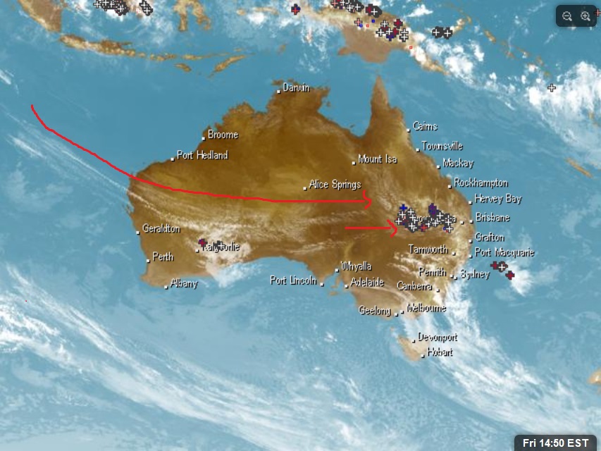 Edited by user Friday, 27 September 2019 3:53:35 PM(UTC)
| Reason: Not specified
|
5 users thanked crikey for this useful post.
|
|
|
|
Rank: Advanced Member
Groups: Registered
Joined: 2/09/2019(UTC) Posts: 105 Location: Brisbane Thanks: 145 times
Was thanked: 561 time(s) in 103 post(s)
|
Interestingly for late tonight/overnight/early Sat morning, some models have been suggesting the possibility of additional activity sweeping across parts of SEQ but whether or not this occurs partly depends on what happens before then i.e. it's a realistic possibility if there isn't too much activity later this afternoon/early evening before then to stabilise the atmosphere and passing cold air aloft helps with instability..... on the other hand, if too much activity occurs before then, it may stabilise the atmosphere too much for it to occur. Overnight activity is historically pretty hard to forecast for. Saturday's also looks to me like one of those setups which is also historically very hard to forecast for because it partly depends the amount of any cloud cover and early activity during the daylight hours.... as well as a question mark over the amount of moisture left later in the day with a westerly flow invading much of the atmosphere (models currently still suggest some activity redeveloping later in the day though). Once again, total rainfall amounts look pretty modest again not surprisingly. ACCESS-C: https://www.youtube.com/watch?v=...Fns&feature=youtu.be
|
6 users thanked Ken for this useful post.
|
|
|
|
Rank: Advanced Member
Groups: Registered
Joined: 13/09/2019(UTC)
Posts: 118
Location: Caboolture (the next Las Vegas!)
Thanks: 215 times
Was thanked: 297 time(s) in 100 post(s)
|
Thank you for the information Ken. So far this afternoon everything seems to be south of Brisbane with a cell approaching Archerfield quite nicely. We had a tiny shower up here in Cabo, but only enough to dampen the dust. Fingers crossed for tonight.
|
4 users thanked DelBoy for this useful post.
|
|
|
|
Rank: Advanced Member
Groups: Registered
Joined: 26/08/2019(UTC) Posts: 50 Location: Perth Thanks: 74 times
Was thanked: 56 time(s) in 20 post(s)
|
I been looking for some working cams in the Brisbane region and struggled to find working ones that aren't road traffic. I see a storm heading for Brisbane on the radar . The best l could do was this snap from the Archerfield aero showing what l think is part of the rain shaft of the storm heading for Brisbane. I think the high rise in Brisbane should get some good views of the storm skirting past https://weathercams.airs...port=archerfield-airport
|
6 users thanked thunderman for this useful post.
|
|
|
|
Rank: Advanced Member
Groups: Registered
Joined: 26/08/2019(UTC) Posts: 50 Location: Perth Thanks: 74 times
Was thanked: 56 time(s) in 20 post(s)
|
Here is another one. The sun is setting but quite a sinister picture of the rainshaft  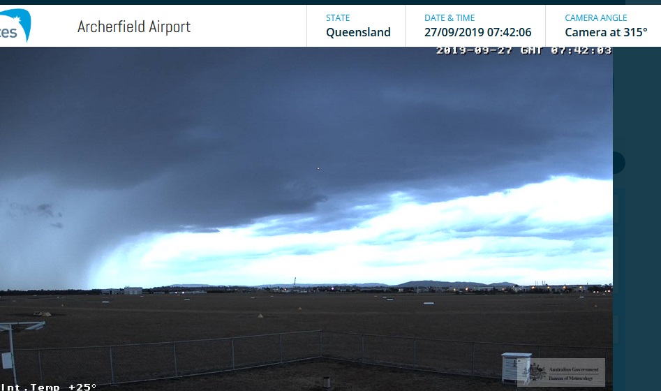
|
6 users thanked thunderman for this useful post.
|
|
|
|
Rank: Advanced Member
Groups: Registered
Joined: 24/08/2019(UTC) Posts: 292 Location: Country Victorian Thanks: 580 times
Was thanked: 503 time(s) in 194 post(s)
|
Regarding overnight activity that Ken has mentioned.
ACC r has medium precip' signal around midnight. A NW/SE band that runs from about Charlevi'le through Roma and Gympie.
A surface trough line
The rain signal looks north of Brisbane of l have my latitude and towns correct.Looks a bit more sunshine coast , hinterlands and west of sunshine coast hinterlands.
Contracts NE towards Rockhampton in the early hours of tomorrow morning
 source http://www.bom.gov.au/au...harts/viewer/index.shtmlEdited by user Friday, 27 September 2019 7:01:29 PM(UTC)
| Reason: Not specified
|
5 users thanked crikey for this useful post.
|
|
|
|
Rank: Newbie
Groups: Registered
Joined: 22/09/2019(UTC) Posts: 3 Location: Kingaroy Thanks: 7 times
Was thanked: 20 time(s) in 3 post(s)
|
Just started raining here in Kingaroy, we'll see how this goes.
At least it's relaxing.
|
6 users thanked Kazzanot47anymore for this useful post.
|
|
|
|
Rank: Newbie
Groups: Registered
Joined: 26/09/2019(UTC) Posts: 5 Location: Melbourne Thanks: 8 times
Was thanked: 6 time(s) in 4 post(s)
|
Originally Posted by: Kazzanot47anymore Just started raining here in Kingaroy, we'll see how this goes.
At least it's relaxing.
Great stuff Kazza. I guess you have possibly forgotten what the sound of rain on the roof sounds like. It has been a while since a good drop up where you are!
|
2 users thanked CharlieBrown for this useful post.
|
|
|
|
Weather Forum
»
Australia Weather
»
SEQ and NE NSW
»
QLD trough and rain 26th Sep - 2nd Oct 2019
Forum Jump
You cannot post new topics in this forum.
You cannot reply to topics in this forum.
You cannot delete your posts in this forum.
You cannot edit your posts in this forum.
You cannot create polls in this forum.
You cannot vote in polls in this forum.
Important Information:
The Weather Forum uses cookies. By continuing to browse this site, you are agreeing to our use of cookies.
More Details
Close
