Weather Forum
»
Australia Weather
»
SEQ and NE NSW
»
QLD trough and rain 26th Sep - 2nd Oct 2019
Rank: Advanced Member
Groups: Registered
Joined: 24/08/2019(UTC) Posts: 292  Location: Country Victorian Thanks: 580 times
Was thanked: 503 time(s) in 194 post(s)
|
I thought seeing there was already discussion on the possibility of this event and some model divergence.
Thought it would be good to give this its own thread.
After all rain has been sparse in this region.
Just the prospect should drum up some interest.
ACC g has are precipitation signal near troughing line in QLD and it seems to hang around, stall? for a few days.
Lets hope something comes of this for everyone who needs it.
A drop,of pressure over Darwin means a positive shift in the SOI
 source http://www.bom.gov.au/au...chartSubmit=Refresh+ViewEdited by moderator Sunday, 29 September 2019 7:14:05 PM(UTC)
| Reason: Not specified
|
 6 users thanked crikey for this useful post.
|
|
|
|
Rank: Advanced Member
Groups: Registered
Joined: 21/09/2019(UTC) Posts: 32 Location: Gold coast Thanks: 125 times
Was thanked: 126 time(s) in 31 post(s)
|
|
3 users thanked juztchillin for this useful post.
|
|
|
|
Rank: Advanced Member
Groups: Registered
Joined: 23/08/2019(UTC) Posts: 155 Location: Narangba Thanks: 280 times
Was thanked: 442 time(s) in 136 post(s)
|
Haha... You beat me to it! Mainly because I didn't know what to write about it. Fingers crossed the planets (well wind really) align and we get something. I would be bloody impressed if it does, because the timing would be almost perfect to what Ken said over one week ago in the day to day thread.  Great links juztchillin  Edited by user Monday, 23 September 2019 7:32:02 PM(UTC)
| Reason: Not specified
|
3 users thanked CantSpellNarangba for this useful post.
|
|
|
|
Rank: Advanced Member
Groups: Registered
Joined: 24/08/2019(UTC) Posts: 292 Location: Country Victorian Thanks: 580 times
Was thanked: 503 time(s) in 194 post(s)
|
A small downgrade by ACC . However l think that most of that is due tothe start of the event appearing on ACC r which always shows a weaker rain signal than ACC g.
The weak precipitation signal on thursday afternoon is appearing mainly during diurnal max on the 4pm time slot.
This tends to indicate convective activity with embedded storms a possibility.?
The signal has a NW/SE orientation and runs roughly from Winton to the border at Tweed heads.
see map below
Friday afternoon the signal looks stronger.

|
4 users thanked crikey for this useful post.
|
|
|
|
Rank: Advanced Member
Groups: Registered
Joined: 23/08/2019(UTC) Posts: 155 Location: Narangba Thanks: 280 times
Was thanked: 442 time(s) in 136 post(s)
|
WATL (as it currently stands) has a small amount of colour for Friday and Saturdays but less than a couple of mm.  
|
4 users thanked CantSpellNarangba for this useful post.
|
|
|
|
Rank: Advanced Member
Groups: Registered
Joined: 24/08/2019(UTC) Posts: 292 Location: Country Victorian Thanks: 580 times
Was thanked: 503 time(s) in 194 post(s)
|
Thanks for the rainfall forecast CSN.
The ACC r totals look generally small. The troughing lasts for 4 days . From thursday lunch on into next monday with pretty much
the same thing each day. Diurnal max precipitation signal in the afternoon.
A small amount of coral infeed perhaps. If there are storms then some would get more.
Of concern is the high pressure cell south of the rain band which if expands northward would push the rain band northward .
|
3 users thanked crikey for this useful post.
|
|
|
|
Rank: Advanced Member
Groups: Registered
Joined: 21/09/2019(UTC) Posts: 32 Location: Gold coast Thanks: 125 times
Was thanked: 126 time(s) in 31 post(s)
|
Quite a bit of cloud cover rolling in from the QLD interior. With some speckles of rain in the west of the state.
Some nice thick grey cloud about this morning
The BOM forecast giving the Gold coast very little currently.
Thursday 26 September
Summary
Min 12
Max 23
Shower or two.
Possible rainfall: 0 to 2 mm
Chance of any rain: 60%
Gold Coast area
Cloudy. Medium (60%) chance of showers, most likely from the late morning. Light winds becoming northeasterly 15 to 25 km/h in the middle of the day then tending northerly 15 to 20 km/h in the evening.
The synoptic has some rain pencilled in sparodically over the next few days , so l am up for any surprises
[img]http://www.bom.gov.au/australia/charts/4day_col.shtml[/img]
|
3 users thanked juztchillin for this useful post.
|
|
|
|
Rank: Advanced Member
Groups: Registered
Joined: 24/08/2019(UTC) Posts: 292 Location: Country Victorian Thanks: 580 times
Was thanked: 503 time(s) in 194 post(s)
|
Quite cloudy at the Tweed.Took a photo down near Pottsville today. Showing the thicker cloud is over the hinterland.
East is Sunny out at sea
The 10am synoptic shows at the border we are at the tail end of the trough here already.
BTW. The radio weather news said chance of storms on friday afternoon 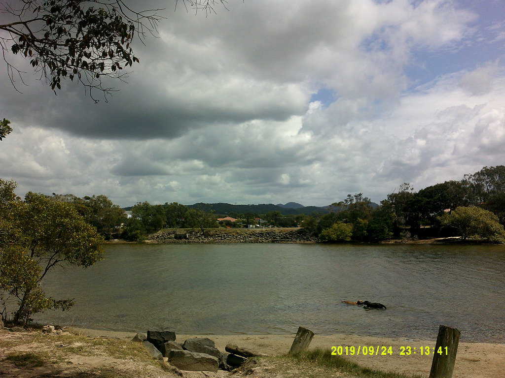
|
4 users thanked crikey for this useful post.
|
|
|
|
Rank: Advanced Member
Groups: Registered
Joined: 21/09/2019(UTC) Posts: 32 Location: Gold coast Thanks: 125 times
Was thanked: 126 time(s) in 31 post(s)
|
Nice picture Crikey.Love the dogs. That is a nice place. Know it well  Ok .So now we have gone from a forecast of no storms , to storms Friday and now they appear on tomorrows forecast. So this gets more interesting. List of towns with storms possible on their forecast Esk, Gatton,Laidley, Dalby,,Toowoomba , Warwick, Chinchilla, Miles, Oakey,Kingaroy,,Rolleston,Taroom, Tambo,,Roma,AugThella,Injune The forecast all says late storms .A great start to this event Edited by user Wednesday, 25 September 2019 6:01:14 PM(UTC)
| Reason: Not specified
|
3 users thanked juztchillin for this useful post.
|
|
|
|
Rank: Advanced Member
Groups: Registered
Joined: 15/09/2019(UTC) Posts: 39 Location: Forster NSW mid coast Thanks: 172 times
Was thanked: 135 time(s) in 39 post(s)
|
|
3 users thanked i4hanish for this useful post.
|
|
|
|
Rank: Advanced Member
Groups: Registered
Joined: 2/09/2019(UTC) Posts: 105 Location: Brisbane Thanks: 145 times
Was thanked: 561 time(s) in 103 post(s)
|
LI = the temp of the environmental air at the height of the 500hpa pressure level (about 18,500 feet up) - the temp of an air parcel if it was lifted to that height (nominally from the surface).
So for example, if the temp of an air parcel that rose to the 500hpa height was -10C and the surrounding air at that height was -15C, the LI would be -5.
In other words, negative LI values indicate that the air parcel is still staying warmer than the surrounding air at that height and therefore will want to keep rising (which are needed to form thunderstorms). The more negative an LI value, the more unstable the air (generally speaking).
BUT just like other indices that measure instability, it relies on various assumptions and has limitations. For example, if the forecast moisture or temp of the air parcel that rises from the surface doesn't reflect reality, the forecast LI value also won't be realistic. Furthermore, parcels of air often don't rise just from the surface on sunny warm days when the lower atmosphere is thoroughly mixed (instead, they rise from that mixed layer that can be thousands of feet deep) so the surface LI values you see on BSCH charts aren't always representative of true instability. And lastly, LI only uses a single fixed height (500hpa) so there can be situations where the temp difference between a rising air parcel and the surrounding environmental air is different at other heights which in turn affects the true instability. CAPE partly overcomes this limitation because it integrates the temp difference through all heights where the parcel stays warmer than the surrounding air but it too, relies on assumptions about the air parcel.
This is why it's a lot better to check forecast soundings (side-on profiles of the atmosphere at any given point) to get an idea of what the instability is like through the whole atmosphere but it can be daunting for people to try and interpret if they're not used to it so LI's still do give a rough idea of where there may be instability.
Any afternoon/evening thunderstorm activity that occurs tomorrow looks somewhat isolated in nature to me, and mainly over inland and southern parts of our region.
|
8 users thanked Ken for this useful post.
|
|
|
|
Rank: Advanced Member
Groups: Registered, Administrators Joined: 21/08/2019(UTC) Posts: 941 Location: Brisbane Northside Thanks: 1198 times
Was thanked: 1136 time(s) in 674 post(s)
|
Originally Posted by: i4hanish  We are building a thread about thunderstorms and forecasting them. It was started by Squall19. I have been trying to make everything simple. The next part of the thread will be looking at Soundings and how to understand them. I need to really get that part posted ASAP. We are trying to get everyone involved, their input and also for people to ask lots of questions. It will be fun. https://www.weatherforum...-formation-and-structure |
Colin Maitland. |
8 users thanked Colmait for this useful post.
|
|
|
|
Rank: Advanced Member
Groups: Registered
Joined: 15/09/2019(UTC) Posts: 39 Location: Forster NSW mid coast Thanks: 172 times
Was thanked: 135 time(s) in 39 post(s)
|
Thank you so much for that detailed explanation of LI KEN . It is worthwhile keeping so l will copy and paste it in the thunderstorm section where it will not be lost. Thanks colmait for your tutorial on thunderstorms . I have been reading and will continue to follow. I look forward to checking the radar tomorrow to see how the forecast goes. I have been looking at some sites on forecasting models.,Way too technical for me. 
|
5 users thanked i4hanish for this useful post.
|
|
|
|
Rank: Member
Groups: Registered
Joined: 23/08/2019(UTC) Posts: 21 Location: St. Kilda Thanks: 32 times
Was thanked: 30 time(s) in 19 post(s)
|
I normally click on other forums, but found my way here... Great explanation and nice and simple for me to learn. Thank you Ken!
|
4 users thanked StKildaClare for this useful post.
|
|
|
|
Rank: Advanced Member
Groups: Registered
Joined: 15/09/2019(UTC) Posts: 39 Location: Forster NSW mid coast Thanks: 172 times
Was thanked: 135 time(s) in 39 post(s)
|
The false color satellite is showing some convection and potential in the areas forecast. Also in the negative lifted Index area forecast.
  Edited by user Thursday, 26 September 2019 9:12:55 AM(UTC)
| Reason: Not specified
|
2 users thanked i4hanish for this useful post.
|
|
|
|
Rank: Advanced Member
Groups: Registered
Joined: 2/09/2019(UTC) Posts: 105 Location: Brisbane Thanks: 145 times
Was thanked: 561 time(s) in 103 post(s)
|
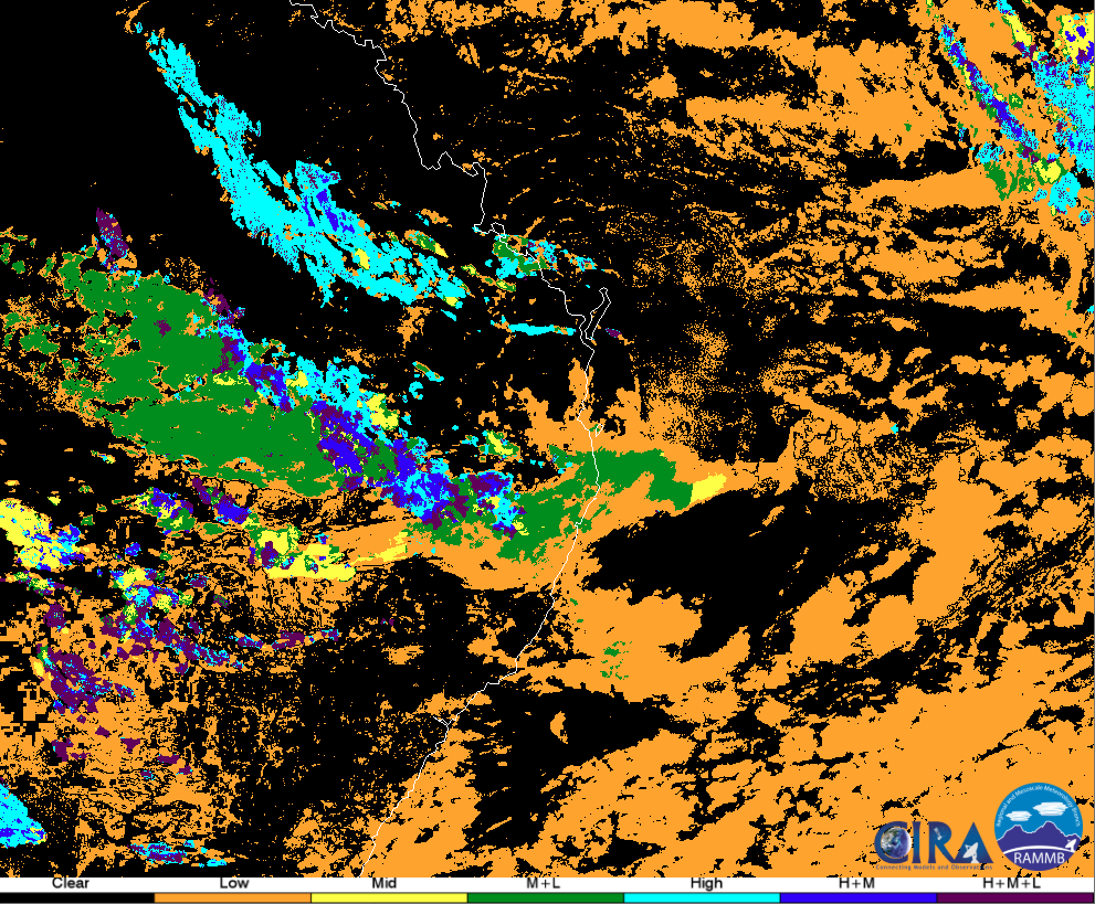 Most of that's actually just fairly flat low cloud near the coast at the moment with some patchy midlevel cloud as well as you can see in the latest post-processed Himawari satellite imagery above (the colour legend is on the bottom). There's some deeper cloud further inland although it's not producing much at the moment. Ideally, you actually want less cloud cover at this time of day so the sun can heat the surface a lot more but there may still be some activity this afternoon and night, mainly favouring southern and possibly western parts. Edited by user Thursday, 26 September 2019 9:24:08 AM(UTC)
| Reason: Not specified
|
7 users thanked Ken for this useful post.
|
|
|
|
Rank: Advanced Member
Groups: Registered
Joined: 7/09/2019(UTC) Posts: 67 Location: Brisbane Thanks: 113 times
Was thanked: 207 time(s) in 61 post(s)
|
Wonderful information i4Hamish and Ken. Lots of great information and images to learn from. I live the post-processing image too. I wonder if that is done on cloud top temperature from IR images, or some funky measuring of altitude? Just had a tiny shower of rain here. More drizzle, with a couple of larger drops. Nothing that can be measured though. (What I love is there doesn't seem to be any egos here, like I have seen in other forums in the past. A group of people sharing ideas and knowledge to help everyone learn. ) Edited by user Thursday, 26 September 2019 10:12:04 AM(UTC)
| Reason: I had managed to type great 5 times in one message! My English teach would not have been happy.
|
5 users thanked SatMan for this useful post.
|
|
|
|
Rank: Advanced Member
Groups: Registered
Joined: 31/08/2019(UTC) Posts: 38 Location: Victoria Thanks: 59 times
Was thanked: 40 time(s) in 19 post(s)
|
The technology we have these days is outstanding. We can really appreciate the science that is involved in weather watching. I for one am absolutely captivated.!
|
3 users thanked whiskyzulu2 for this useful post.
|
|
|
|
Rank: Advanced Member
Groups: Registered
Joined: 21/09/2019(UTC) Posts: 32 Location: Gold coast Thanks: 125 times
Was thanked: 126 time(s) in 31 post(s)
|
Lightning tracker showing a strike or 2 out west QLD way. The national loop showing increasing convection along the trough line as expected. https://www.lightningmap...ceania/index.php?lang=enI have to report . We have a troughy mess upstairs in the sky. On the ground a daily continues layer of greasy , dusty particles on everything. The car and entertaining area just covered. Again. Not sure if the car will get a free wash today Headlines from the Gold Coast SUN newspaper. Honey production down by 20% due to bush fires and drought. The suppliers warning of price increases. Canungra , Mt Tamborine and Mudgereba badly affected
|
2 users thanked juztchillin for this useful post.
|
|
|
|
Rank: Advanced Member
Groups: Registered
Joined: 15/09/2019(UTC) Posts: 39 Location: Forster NSW mid coast Thanks: 172 times
Was thanked: 135 time(s) in 39 post(s)
|
I am quite impressed with the lifted index forecast by GFS (bsch stormcast) The current activity is exactly where it was forecast to be .Charleville ,Roma way Might have a look at tomorrows a bit later on. 
|
2 users thanked i4hanish for this useful post.
|
|
|
|
Weather Forum
»
Australia Weather
»
SEQ and NE NSW
»
QLD trough and rain 26th Sep - 2nd Oct 2019
Forum Jump
You cannot post new topics in this forum.
You cannot reply to topics in this forum.
You cannot delete your posts in this forum.
You cannot edit your posts in this forum.
You cannot create polls in this forum.
You cannot vote in polls in this forum.
Important Information:
The Weather Forum uses cookies. By continuing to browse this site, you are agreeing to our use of cookies.
More Details
Close
