Weather Forum
»
Australia Weather
»
Central Queensland
»
Central Queensland - Day to Day weather
Rank: Advanced Member
Groups: Registered
Joined: 3/09/2019(UTC) Posts: 51  Location: gladstone Thanks: 108 times
Was thanked: 50 time(s) in 26 post(s)
|
WOW.Exciting. Bileola only 120km west of Gladstone has come on board for a possible late storm today  and also Taroom Wide Bay and Burnett districts got a fullhouse .Storm forecast for all  Edited by user Saturday, 28 September 2019 8:37:02 AM(UTC)
| Reason: Not specified
|
 1 user thanked oceangyre for this useful post.
|
|
|
|
Rank: Advanced Member
Groups: Registered
Joined: 15/09/2019(UTC) Posts: 39 Location: Forster NSW mid coast Thanks: 172 times
Was thanked: 135 time(s) in 39 post(s)
|
There is a couple of small thunder cells heading for the coast toward Hervey bay Bundaberg possibly this evening? Currently a cell passing through Injune I thought l would post this CAPE map showing a small amount of CAPE on the mid coast tomorrow afternoon.Just to see what happens? 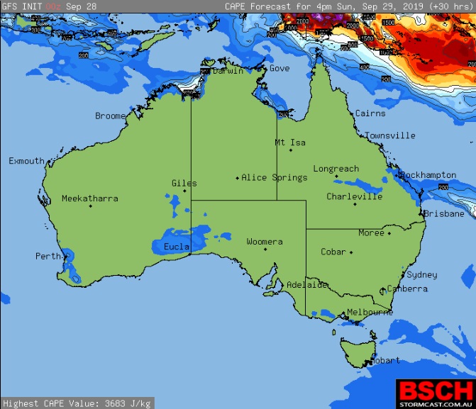
|
2 users thanked i4hanish for this useful post.
|
|
|
|
Rank: Advanced Member
Groups: Registered
Joined: 24/08/2019(UTC) Posts: 292 Location: Country Victorian Thanks: 580 times
Was thanked: 503 time(s) in 194 post(s)
|
ACC r has no precipitation for this region tomorrow but will look with interest re the CAPE on the coast.
..............
Of interest to me and no doubt people in this region is ACC g forecast for the Tuesday 1st Oct 2019.
This is a day event with a tropical dip in isobars. Sub Tropical troughing .
It not only could deliver some stormage to the coast but also the precip' signal extends inland as well.Rain signal moderate
but a storm might give something tolocalized spots. Lets see how this unfolds.

|
1 user thanked crikey for this useful post.
|
|
|
|
Rank: Advanced Member
Groups: Registered
Joined: 3/09/2019(UTC) Posts: 51 Location: gladstone Thanks: 108 times
Was thanked: 50 time(s) in 26 post(s)
|
WOW what a good looking forecast from Access. Hope even some of that eventuates. Chance of showers today from the CAPE that has been forecast Tuesday forecast some signs of something emerging Tuesday 1 October Summary Min 18 Max 27 Shower or two. Possible rainfall: 0 to 8 mm Chance of any rain: 50% Partly cloudy. Medium (50%) chance of showers, most likely in the morning and afternoon. Light winds becoming east to southeasterly 25 to 35 km/h during the morning. Edited by user Sunday, 29 September 2019 9:16:01 AM(UTC)
| Reason: Not specified
|
1 user thanked oceangyre for this useful post.
|
|
|
|
Rank: Advanced Member
Groups: Registered
Joined: 3/09/2019(UTC) Posts: 51 Location: gladstone Thanks: 108 times
Was thanked: 50 time(s) in 26 post(s)
|
and YES We have an upgrade in the forecast for tuesday Tuesday 1 October Summary Min 19 Max 26 A few showers. Possible storm.
Possible rainfall: 6 to 15 mm
Chance of any rain: 95%
Cloudy. Very high (95%) chance of showers. The chance of a thunderstorm. Light winds becoming easterly 20 to 25 km/h in the morning Firstly. Did you know that 4 states of Australia have a town called Gladstone . I learnt that just now from Climate data online.  According to this months records ,Gladstone has only had 2.2 mm of rain.The mean is 26.5mm. According to this months records ,Gladstone has only had 2.2 mm of rain.The mean is 26.5mm.So well behind. When l looked at this years rain records l was shocked at how far below average Gladstone has been.  I will take a screen dump of that tomorrow and post tomorrow.
|
1 user thanked oceangyre for this useful post.
|
|
|
|
Rank: Advanced Member
Groups: Registered
Joined: 24/08/2019(UTC) Posts: 292 Location: Country Victorian Thanks: 580 times
Was thanked: 503 time(s) in 194 post(s)
|
I am just trying to get a handle on what towns that sit under the stronger precip' signal from the ACC r forecast on Tuesday the 1st october
This is the best l could do and it is a ROUGH estimate.
The black line encloses the general area of instability in the SE quadrant of QLD.
The purple lines mark in the corridor of strongest instability or stronger precip' signal.

|
1 user thanked crikey for this useful post.
|
|
|
|
Rank: Advanced Member
Groups: Registered
Joined: 3/09/2019(UTC) Posts: 51 Location: gladstone Thanks: 108 times
Was thanked: 50 time(s) in 26 post(s)
|
Originally Posted by: crikey  I am just trying to get a handle on what towns that sit under the stronger precip' signal from the ACC r forecast on Tuesday the 1st october
This is the best l could do and it is a ROUGH estimate.
The black line encloses the general area of instability in the SE quadrant of QLD.
The purple lines mark in the corridor of strongest instability or stronger precip' signal.
Some rainfall forecasts that fall in that corridor marked with the purple lines Just fabulous for those who need it the most. Its not a drought breaker by any means. Tuesday 1st October 2019 Rain forecast BOM forecast by towns Bundaberg 95% chance 6-15mm. Thunderstorm Gympie 70%chance of 2-8mm Hervey Bay 90% chance 5-15mm Maryborough 90% chance 4-10 mm Rockhamton 80%chance of 3-10mm Emerald 80% chance 4-15mm Taroom 80%chance of 3-10mm Roma 50%chance 1mm storm Its possible those totals could be bigger with storms?
|
|
|
|
|
|
Rank: Advanced Member
Groups: Registered
Joined: 3/09/2019(UTC) Posts: 51 Location: gladstone Thanks: 108 times
Was thanked: 50 time(s) in 26 post(s)
|
|
|
|
|
|
|
Rank: Advanced Member
Groups: Registered
Joined: 3/09/2019(UTC) Posts: 51 Location: gladstone Thanks: 108 times
Was thanked: 50 time(s) in 26 post(s)
|
|
|
|
|
|
|
Rank: Advanced Member
Groups: Registered
Joined: 3/09/2019(UTC) Posts: 51 Location: gladstone Thanks: 108 times
Was thanked: 50 time(s) in 26 post(s)
|
Gladstone is up to 6mm today. A nice street cleaner. Radar looks good for some more . Yeppoon up to 12.4mm 4.20pm Theodore storm cell looks a bit feisty. Heading nth towards MOURA. However most of the rain cells heading east toward off shore. 
|
|
|
|
|
|
Rank: Advanced Member
Groups: Registered
Joined: 24/08/2019(UTC) Posts: 292 Location: Country Victorian Thanks: 580 times
Was thanked: 503 time(s) in 194 post(s)
|
The rain / storm activity contracts northward overnight as high pressure expands northward.
ACC r weak rain signal is mainly coastal and the ranges tomorrow between Hervey bay (25s) and Mackay.
Could be storms .
source http://www.bom.gov.au/au...harts/viewer/index.shtml
|
1 user thanked crikey for this useful post.
|
|
|
|
Rank: Advanced Member
Groups: Registered
Joined: 3/09/2019(UTC) Posts: 51 Location: gladstone Thanks: 108 times
Was thanked: 50 time(s) in 26 post(s)
|
Originally Posted by: crikey The rain / storm activity contracts northward overnight as high pressure expands northward.
ACC r weak rain signal is mainly coastal and the ranges tomorrow between Hervey bay (25s) and Mackay.
Could be storms .
source http://www.bom.gov.au/au...harts/viewer/index.shtml The 7news central Queensland has a warning for bad weather .
This twitter link has a BOM rep' explaining the situation.
https://twitter.com/7New...atus/1178952429808652289
Trough to hang around for 4days
Could be severe storms
Some places could get 40mm
Watch the twitter video. Well presented
|
|
|
|
|
|
Rank: Advanced Member
Groups: Registered
Joined: 3/09/2019(UTC) Posts: 51 Location: gladstone Thanks: 108 times
Was thanked: 50 time(s) in 26 post(s)
|
Sky news has onshore showers up the coast line today and as far inland as Emerald.? This mornings radar showing some light onshore activity around Townsville and Innisfall this morning 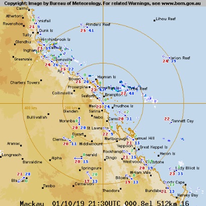
|
|
|
|
|
|
Rank: Advanced Member
Groups: Registered
Joined: 3/09/2019(UTC) Posts: 51 Location: gladstone Thanks: 108 times
Was thanked: 50 time(s) in 26 post(s)
|
As forecast onshore showers from sunshine coast to Innisfall pushing in across the ranges. Radar picture. 2.30pm Just small total so far but afternoon storms ? exit I few strikes near Bundaberg ,Maryborough area.  Edited by user Wednesday, 2 October 2019 3:11:18 PM(UTC)
| Reason: Not specified
|
|
|
|
|
|
Rank: Advanced Member
Groups: Registered
Joined: 3/09/2019(UTC) Posts: 51 Location: gladstone Thanks: 108 times
Was thanked: 50 time(s) in 26 post(s)
|
This Saturday (12th Oct). looking very promising for Gladstone .Some rain . 80% chance of 5-10mm with thunderstorm
|
|
|
|
|
|
Rank: Advanced Member
Groups: Registered
Joined: 3/09/2019(UTC) Posts: 51 Location: gladstone Thanks: 108 times
Was thanked: 50 time(s) in 26 post(s)
|
Gladstone airport 14.2mm since 9am Rockhampton 10.8mm Just west much less. A mm or so Proserpine 29.6mm Good one!
|
|
|
|
|
|
Rank: Advanced Member
Groups: Registered
Joined: 3/09/2019(UTC) Posts: 51 Location: gladstone Thanks: 108 times
Was thanked: 50 time(s) in 26 post(s)
|
I forgot to mention. Tomorrows rain forecast for Gladstone Fabulous if this fulfills and a storm perhaps METEYE 
|
|
|
|
|
|
Rank: Advanced Member
Groups: Registered
Joined: 3/09/2019(UTC) Posts: 51 Location: gladstone Thanks: 108 times
Was thanked: 50 time(s) in 26 post(s)
|
The mean rainfall for Gladstone radar station for October is 60.1mm Gladstone had all of that and more on one day. 81mm on the 12th October
The current monthly total is a wonderful 98.5mm. The inland regions not so lucky to date G ladstone climate data online
http://www.bom.gov.au/js..._c=&p_stn_num=039123
|
|
|
|
|
|
Rank: Advanced Member
Groups: Registered
Joined: 3/09/2019(UTC) Posts: 51 Location: gladstone Thanks: 108 times
Was thanked: 50 time(s) in 26 post(s)
|
No rain forecast for Gladstone from the inland trough tomorrow, sunday 27th oct.
However south down toward the Maryborough, Sunshine coast area looks to have more weather of interest. It will be interesting to see how well inland QLD does with this inland trough tomorrow.
|
1 user thanked oceangyre for this useful post.
|
|
|
|
Rank: Advanced Member
Groups: Registered
Joined: 23/08/2019(UTC) Posts: 155 Location: Narangba Thanks: 280 times
Was thanked: 442 time(s) in 136 post(s)
|
|
|
|
|
|
|
Weather Forum
»
Australia Weather
»
Central Queensland
»
Central Queensland - Day to Day weather
Forum Jump
You cannot post new topics in this forum.
You cannot reply to topics in this forum.
You cannot delete your posts in this forum.
You cannot edit your posts in this forum.
You cannot create polls in this forum.
You cannot vote in polls in this forum.
Important Information:
The Weather Forum uses cookies. By continuing to browse this site, you are agreeing to our use of cookies.
More Details
Close
