Weather Forum
»
Australia Weather
»
SEQ and NE NSW
»
QLD trough and rain 26th Sep - 2nd Oct 2019
Rank: Advanced Member
Groups: Registered
Joined: 15/09/2019(UTC) Posts: 39  Location: Forster NSW mid coast Thanks: 172 times
Was thanked: 135 time(s) in 39 post(s)
|
CAPE crusader checking in with a post for tomorrow.
Quite an extensive region colored in here. This shaded area commences as early as 10am tomorrow and goes on throughout the day.
After 7pm the colored area shrinks to the mid coast of QLD and shows higher CAPE near Rockhampton area in the evening
 Edited by user Monday, 30 September 2019 2:07:08 PM(UTC)
| Reason: Not specified
|
 7 users thanked i4hanish for this useful post.
|
|
|
|
Rank: Advanced Member
Groups: Registered
Joined: 15/09/2019(UTC) Posts: 39 Location: Forster NSW mid coast Thanks: 172 times
Was thanked: 135 time(s) in 39 post(s)
|
West of MOREE has some higher level CAPE tomorrow .I managed to get my first sounding from BCSH. 10am I can see two parameters that mean something. LI minus 5 CAPE 588 j/kg I can see two places the red lines come together. At 900hpa low level cloud and 600hpa mid level cloud. This indicates rain??? but Temp 20 dew point 9? 
I have only linked this image so l think it will change
|
6 users thanked i4hanish for this useful post.
|
|
|
|
Rank: Advanced Member
Groups: Registered
Joined: 24/08/2019(UTC) Posts: 292 Location: Country Victorian Thanks: 580 times
Was thanked: 503 time(s) in 194 post(s)
|
OK. I am surprised . We have 2 thunder cells on radar. Out Darlington springbrook way.
west of the Tweed.
Well done BOM nice call
Here is pic' facing west
Amazing. The sky looked quite stable only an hour ago and in such a short time now a stormy look.4pm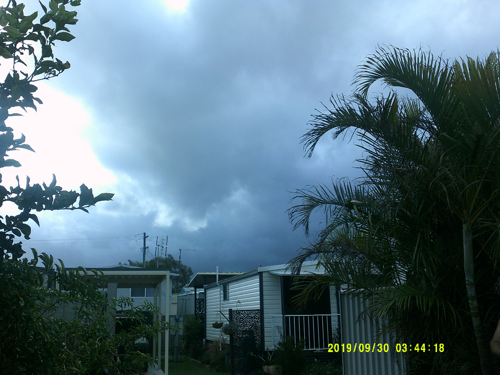 Edited by user Monday, 30 September 2019 3:59:36 PM(UTC)
| Reason: Not specified
|
4 users thanked crikey for this useful post.
|
|
|
|
Rank: Advanced Member
Groups: Registered
Joined: 24/08/2019(UTC) Posts: 292 Location: Country Victorian Thanks: 580 times
Was thanked: 503 time(s) in 194 post(s)
|
|
4 users thanked crikey for this useful post.
|
|
|
|
Rank: Advanced Member
Groups: Registered
Joined: 27/08/2019(UTC) Posts: 47 Location: Bayside Thanks: 51 times
Was thanked: 104 time(s) in 35 post(s)
|
A real down grade on the bom weather. To be expected i supose
|
5 users thanked Tsunami for this useful post.
|
|
|
|
Rank: Advanced Member
Groups: Registered
Joined: 24/08/2019(UTC) Posts: 292 Location: Country Victorian Thanks: 580 times
Was thanked: 503 time(s) in 194 post(s)
|
Originally Posted by: Tsunami  A real down grade on the bom weather. To be expected i supose Upgrades , downgrades. YEP par of the course. The Darlington cell is heading west! toward Kilarney area. They usually head east toward the coast.  Edit. On second thoughts l think it is just growing in size perhaps Edited by user Monday, 30 September 2019 5:03:32 PM(UTC)
| Reason: Not specified
|
6 users thanked crikey for this useful post.
|
|
|
|
Rank: Advanced Member
Groups: Registered
Joined: 27/08/2019(UTC) Posts: 47 Location: Bayside Thanks: 51 times
Was thanked: 104 time(s) in 35 post(s)
|
Would be nice to be under that one in land of you cricky
|
4 users thanked Tsunami for this useful post.
|
|
|
|
Rank: Advanced Member
Groups: Registered, Administrators Joined: 21/08/2019(UTC) Posts: 941 Location: Brisbane Northside Thanks: 1198 times
Was thanked: 1136 time(s) in 674 post(s)
|
Originally Posted by: i4hanish West of MOREE has some higher level CAPE tomorrow .I managed to get my first sounding from BCSH. 10am I can see two parameters that mean something. LI minus 5 CAPE 588 j/kg I can see two places the red lines come together. At 900hpa low level cloud and 600hpa mid level cloud. This indicates rain??? but Temp 20 dew point 9?
I have only linked this image so l think it will change Sorry I have not had time today and I only have a second or two. But if you glance over to the right hand side of the sounding the LI is - 2.29c and the cape is only 263 j/kg. I calculated the LI and came up with the same. But hopefully I will shortly have that part of the soundings finished and be able to post. This morning sounding from the airport is below and you can see the lack of large amounts of instability and strong inversion.  Sorry to run and not answer everything. The bottom of the BSCH highlights the highest LI’s and Cape on the chart and that could be over the ocean or another area. It does trick you up at first. The soundings is all those charts of LIs, cape, sheer, temp, etc on one page, a slice of the atmosphere of 1000mb to 100 mb. That is a lot of charts plus an enormous amount of additional info such as your TotalTotals, CIN etc. I saw Kens answer earlier and it was smack on. That what happens when you have a Met on board. Cheers and sorry. Got to run again. Have not finished everything today. Arghhhhhhhhh!!!!!!!!!!!!! Wife home soon too. |
Colin Maitland. |
6 users thanked Colmait for this useful post.
|
|
|
|
Rank: Advanced Member
Groups: Registered
Joined: 24/08/2019(UTC) Posts: 292 Location: Country Victorian Thanks: 580 times
Was thanked: 503 time(s) in 194 post(s)
|
Originally Posted by: Tsunami Would be nice to be under that one in land of you cricky It might come this way overnight? If it does l will beat the dog crawling under the table. They generally scare me. There is certainly expansion on that area. Expanding toward Boonah now
|
5 users thanked crikey for this useful post.
|
|
|
|
Rank: Advanced Member
Groups: Registered
Joined: 21/09/2019(UTC) Posts: 32 Location: Gold coast Thanks: 125 times
Was thanked: 126 time(s) in 31 post(s)
|
Something approaching the Coolongatta airport. 6.40pm. Looks a bit like a gust front but might be just be the poor light?

|
6 users thanked juztchillin for this useful post.
|
|
|
|
Rank: Advanced Member
Groups: Registered
Joined: 27/08/2019(UTC) Posts: 47 Location: Bayside Thanks: 51 times
Was thanked: 104 time(s) in 35 post(s)
|
Ok
Moderate shower for last 5 min here in cleveland
Nothing obove us on radar
|
5 users thanked Tsunami for this useful post.
|
|
|
|
Rank: Advanced Member
Groups: Registered
Joined: 2/09/2019(UTC) Posts: 105 Location: Brisbane Thanks: 145 times
Was thanked: 561 time(s) in 103 post(s)
|
 Originally Posted by: Tsunami Ok
Moderate shower for last 5 min here in cleveland
Nothing obove us on radar Some showers appear over you on the latest (6:48pm) radar scan as well as just starting to appear on the 6:42pm scan before that. Bearing in mind each scan is basically an accumulation of radar sweeps at different elevations (angles) over the previous several minutes rather than instantaneous. Edited by user Monday, 30 September 2019 7:03:21 PM(UTC)
| Reason: Not specified
|
6 users thanked Ken for this useful post.
|
|
|
|
Rank: Advanced Member
Groups: Registered
Joined: 27/08/2019(UTC) Posts: 47 Location: Bayside Thanks: 51 times
Was thanked: 104 time(s) in 35 post(s)
|
Yea wow
Still showering. Lovely to hear rain
|
6 users thanked Tsunami for this useful post.
|
|
|
|
Rank: Advanced Member
Groups: Registered
Joined: 21/09/2019(UTC) Posts: 32 Location: Gold coast Thanks: 125 times
Was thanked: 126 time(s) in 31 post(s)
|
Another snap from Coolongatta airport cam. I think this one is facing east.Runway and building lights l suppose
 Edited by user Monday, 30 September 2019 7:15:07 PM(UTC)
| Reason: Not specified
|
6 users thanked juztchillin for this useful post.
|
|
|
|
Rank: Advanced Member
Groups: Registered
Joined: 21/09/2019(UTC) Posts: 32 Location: Gold coast Thanks: 125 times
Was thanked: 126 time(s) in 31 post(s)
|
Fascinating watching the storms north of Brisbane heading NW and the storms south of Brisbane heading the other direction NE
|
3 users thanked juztchillin for this useful post.
|
|
|
|
Rank: Advanced Member
Groups: Registered
Joined: 27/08/2019(UTC) Posts: 47 Location: Bayside Thanks: 51 times
Was thanked: 104 time(s) in 35 post(s)
|
Yea wow
Still showering. Lovely to hear rain.
0.6mm from that
Very happy
|
5 users thanked Tsunami for this useful post.
|
|
|
|
Rank: Advanced Member
Groups: Registered, Administrators Joined: 21/08/2019(UTC) Posts: 941 Location: Brisbane Northside Thanks: 1198 times
Was thanked: 1136 time(s) in 674 post(s)
|
Originally Posted by: Colmait Originally Posted by: i4hanish West of MOREE has some higher level CAPE tomorrow .I managed to get my first sounding from BCSH. 10am I can see two parameters that mean something. LI minus 5 CAPE 588 j/kg I can see two places the red lines come together. At 900hpa low level cloud and 600hpa mid level cloud. This indicates rain??? but Temp 20 dew point 9?
I have only linked this image so l think it will change Sorry I have not had time today and I only have a second or two. But if you glance over to the right hand side of the sounding the LI is - 2.29c and the cape is only 263 j/kg. I calculated the LI and came up with the same. But hopefully I will shortly have that part of the soundings finished and be able to post. This morning sounding from the airport is below and you can see the lack of large amounts of instability and strong inversion. Sorry to run and not answer everything. The bottom of the BSCH highlights the highest LI’s and Cape on the chart and that could be over the ocean or another area. It does trick you up at first. The soundings is all those charts of LIs, cape, sheer, temp, etc on one page, a slice of the atmosphere of 1000mb to 100 mb. That is a lot of charts plus an enormous amount of additional info such as your TotalTotals, CIN etc. I saw Kens answer earlier and it was smack on. That what happens when you have a Met on board. Cheers and sorry. Got to run again. Have not finished everything today. Arghhhhhhhhh!!!!!!!!!!!!! Wife home soon too. Hi I4hanish. My real bad, I was in a rush and once again misread the post. It is 10:00 tomorrow, Tuesday, you were talking about and yes, west of Moree has some -5 LIs and some cape and that runs up through central southern QLD. So Moree and surrounds and into St George etc, should get a good chance of a thunderstorm. Although the cape is low I love the TT’s of 57. One of the latest soundings had some nice instability and although weak, the lower level sheer was from the NNE to 800 mb, from the east at 800mb to 500 mb and the upper from the west. Be interesting if it kicks off, to watch the doppler. Sorry about the mix up. One to keep an eye on though. Cheers. |
Colin Maitland. |
5 users thanked Colmait for this useful post.
|
|
|
|
Rank: Advanced Member
Groups: Registered
Joined: 27/08/2019(UTC) Posts: 47 Location: Bayside Thanks: 51 times
Was thanked: 104 time(s) in 35 post(s)
|
Look out cricky. .one comming your way
|
2 users thanked Tsunami for this useful post.
|
|
|
|
Rank: Advanced Member
Groups: Registered
Joined: 25/08/2019(UTC) Posts: 1,839 Location: Ferny Grove Thanks: 985 times
Was thanked: 856 time(s) in 419 post(s)
|
Thunder heard at 8:50 pm from the cells north of Brisbane. A warm day with the cu cloud coverage causing constant rises and falls in the temperature in the morning and into the early afternoon. For the last 2 hours the temperature have been stable at 21 C. Dew point have remained near average and generally stable though temporary dipped in the later in the morning in S to SW winds. Winds since about midday became E to SE and S to SE in the last few hours. Near average relative humidity today. Last 24 hours: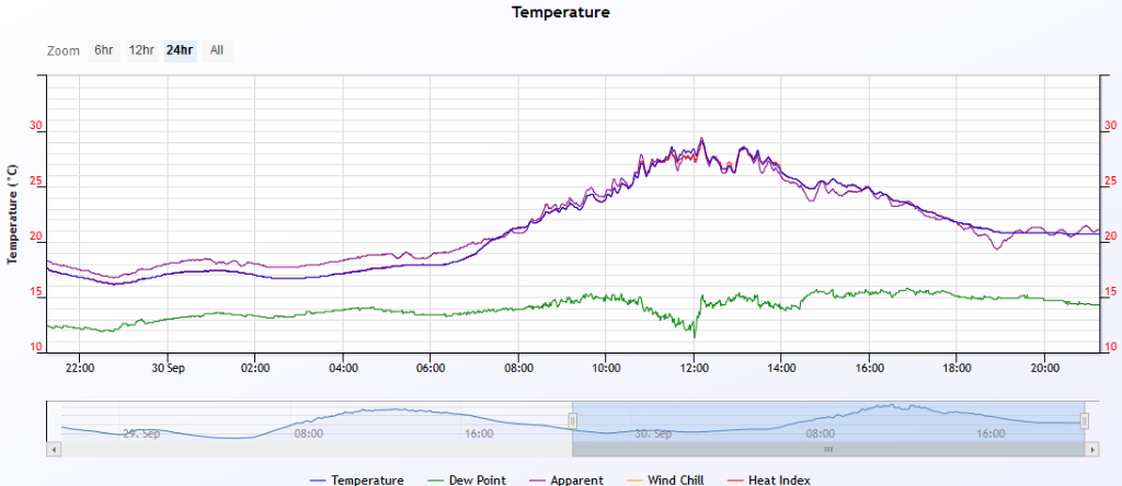  |
|
5 users thanked Falling_Droplet for this useful post.
|
|
|
|
Rank: Member
Groups: Registered
Joined: 20/08/2019(UTC) Posts: 25 Location: Mooloolaba Thanks: 227 times
Was thanked: 110 time(s) in 24 post(s)
|
Just popped out in the car for 15 mins and saw some decent lightning to the south... hoping we get some night action. Lightning always better in the dark. Bit of rain would be nice too...everything has turned brown here and we missed out on anything on Saturday.
|
5 users thanked sharjay for this useful post.
|
|
|
|
Weather Forum
»
Australia Weather
»
SEQ and NE NSW
»
QLD trough and rain 26th Sep - 2nd Oct 2019
Forum Jump
You cannot post new topics in this forum.
You cannot reply to topics in this forum.
You cannot delete your posts in this forum.
You cannot edit your posts in this forum.
You cannot create polls in this forum.
You cannot vote in polls in this forum.
Important Information:
The Weather Forum uses cookies. By continuing to browse this site, you are agreeing to our use of cookies.
More Details
Close
