Weather Forum
»
Australia Weather
»
Tropical Lows and Cyclones
»
Tropical Low 05U-15 January / Cyclone Kirrily (24/01)/Ex Kirrily2024
Rank: Advanced Member
Groups: Registered, Administrators Joined: 21/08/2019(UTC) Posts: 942  Location: Brisbane Northside Thanks: 1198 times
Was thanked: 1136 time(s) in 674 post(s)
|
I started this thread so everyone on the forum can post and join in. I was always taught to put the weather into simple terms so everyone can understand but I can also be very technical if needed. So if you are a member and haven’t posted yet or someone who would like to post a technical post please join in. I am not making light of the serious nature of the tropical low and possible cyclone but just encouraging anyone to post. Colin. Some interesting long range forecast being thrown around by the different modelling systems for SEQLD. It is still a long way out so things can change but worth keeping an eye on the models and see how they fair. These are all for the same timeframe of January 24, except for the ECMWF which only has run till the 20 January. GFS Model is the most aggressive 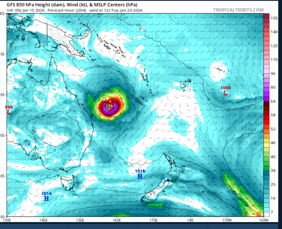 CMC has the same low but further to the East.  NAVGEM  ECMFW, run stops at January 20.  As I said before, it is still a long way out and things can change with each run of the models. But worth keeping an eye on them just in case. Edited by user Saturday, 3 February 2024 6:29:06 AM(UTC)
| Reason: Not specified |
Colin Maitland. |
 1 user thanked Colmait for this useful post.
|
|
|
|
Rank: Advanced Member
Groups: Registered, Administrators Joined: 21/08/2019(UTC) Posts: 942 Location: Brisbane Northside Thanks: 1198 times
Was thanked: 1136 time(s) in 674 post(s)
|
Much the same weather for Tuesday, Showers and maybe thundery showers/storms. With regards to the models hinting at a low/cyclone hitting down in the South East, models have already started to shift their forecast. But as they are very unpredictable it s worth just watching. BoM have come onboard and are watching tropical low 05U. (Technically not until Wednesday) Tropical Low 05U Coral Sea tropical low developing this week A tropical low is expected to develop in the Coral Sea this week and initially move east, away from the Queensland coast. It will likely strengthen on the weekend and could start moving back towards the southwest. It is expected to remain offshore for the next seven days with no direct impacts to the Queensland coast.  |
Colin Maitland. |
1 user thanked Colmait for this useful post.
|
|
|
|
Rank: Advanced Member
Groups: Registered, Administrators Joined: 21/08/2019(UTC) Posts: 942 Location: Brisbane Northside Thanks: 1198 times
Was thanked: 1136 time(s) in 674 post(s)
|
This is the latest from BoM regarding the Tropical Low 05U/ possible TC Forecast track path valid Sunday 21 January 2024 for Tropical Low 05U / possible TC  Latest Spaghetti Ensemble of the possible track paths it could take  The areas that maybe affected by the Low O5U / possible TC  Technical data available for the system IDQ20065 Australian Bureau of Meteorology Tropical Cyclone Warning Centre TROPICAL CYCLONE INFORMATION BULLETIN Issued at 10:54 am EST on Sunday 21 January 2024 At 10 am AEST Sunday, a Tropical Low with central pressure 998 hPa was located over the Coral sea near latitude 15.0 south longitude 154.4 east, which is about 495 km east northeast of Willis Island and 940 km east northeast of Townsville. The low is slow moving and should gradually intensify over the next 24 hours. Tropical Low 05U is developing in the Coral Sea and is forecast to track towards the Queensland coast. A coastal crossing is likely around the middle of the week, with the most likely zone being between about Cairns and Mackay. A severe coastal impact is possible, particularly if the system crosses near or south of Townsville. The next Information Bulletin will be issued by 5 pm AEST today. |
Colin Maitland. |
1 user thanked Colmait for this useful post.
|
|
|
|
Rank: Advanced Member
Groups: Registered, Administrators Joined: 21/08/2019(UTC) Posts: 942 Location: Brisbane Northside Thanks: 1198 times
Was thanked: 1136 time(s) in 674 post(s)
|
Latest offering by BoM on Meteye regardingTropical Low 05U. Unfortunately you can’t go forward to see the possible/predicted path or strength. It is only available for the time presented.  |
Colin Maitland. |
1 user thanked Colmait for this useful post.
|
|
|
|
Rank: Advanced Member
Groups: Registered, Administrators Joined: 21/08/2019(UTC) Posts: 942 Location: Brisbane Northside Thanks: 1198 times
Was thanked: 1136 time(s) in 674 post(s)
|
Just having a look at the 512K Willis Island Radar and the low is still heading in a NNE direction. As per the doppler radar you can see the main system is moving away from the radar, that is North of the radar. This is in line with 10:00am- 10:00pm 21 /01/24 track path.  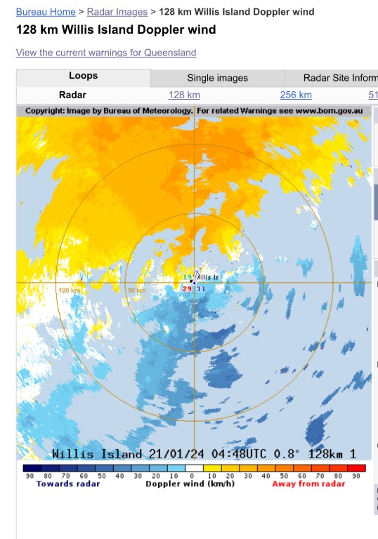 Track path showing todays slight movement to the North. 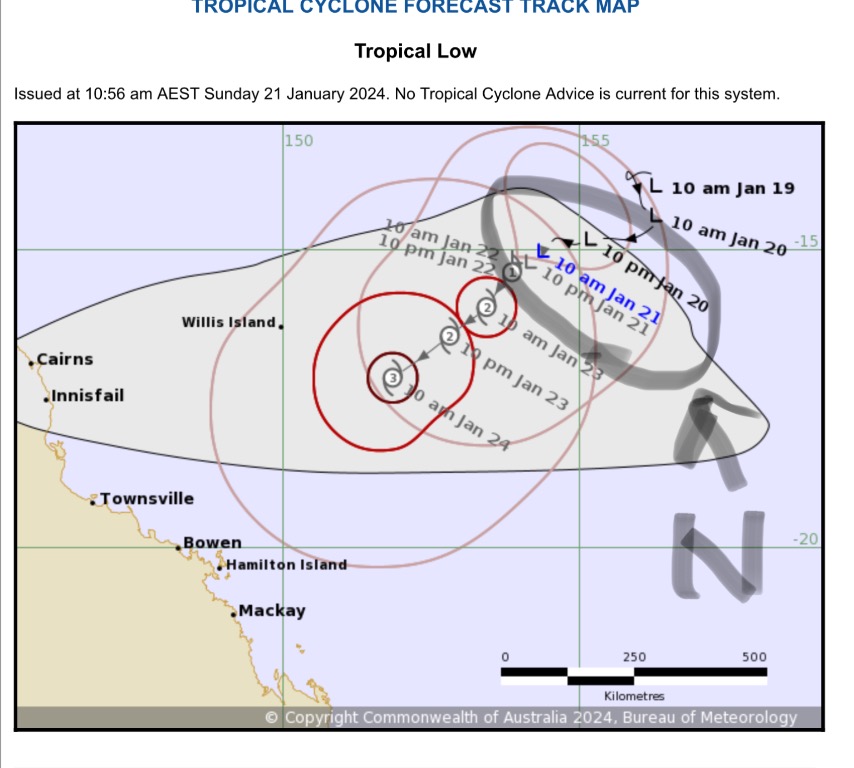 I just find this little things interesting. |
Colin Maitland. |
1 user thanked Colmait for this useful post.
|
|
|
|
Rank: Advanced Member
Groups: Registered, Administrators Joined: 21/08/2019(UTC) Posts: 942 Location: Brisbane Northside Thanks: 1198 times
Was thanked: 1136 time(s) in 674 post(s)
|
Tropical Low 05U not a lot has changed at this stage. It is very slow moving but should start to move a little to the West. The models are sort of coming into a alignment in small variations but it is still a long way out in the life of a Tropical Low/Cyclone. The latest Meteye has the Tropical storm moving inland still and moving a little further south with a recurve towards the coast. But once again we are a long way out. The best way to describe this scenario comes down to Lorenzo’s chaos theory that he discovered while running a weather model in the 1950’s. It became better known as the butterfly effect. The small changes added together can make a bigger change to a storm system such as 05U. So at this stage stay cool and here is the latest Meteye run from BoM.  |
Colin Maitland. |
1 user thanked Colmait for this useful post.
|
|
|
|
Rank: Advanced Member
Groups: Registered, Administrators Joined: 21/08/2019(UTC) Posts: 942 Location: Brisbane Northside Thanks: 1198 times
Was thanked: 1136 time(s) in 674 post(s)
|
Just saw an update and there has been a slight movement to the North with the possible crossing of the Coast. This is where the models will jump around so much. Those tiny butterfly effects. But it is just worth keeping an archive of the movement in the models for future references. This all could change in the next few hours. The other scenario is it could burn it self out by using a lot of the warm water it is sitting over. So many variables to consider. Time will tell us what is happening. Posted this Meteye stormcast this morning.  This is the latest and you can see the crossing is closer to Townsville at this point in time. Be interesting to see where it does eventually cross and if it does cross is another scenario. So many variables as I said before. The main thing is to prepare for the worse and hope for the best. That is all we can do. Keep an eye and ear to all the advice/warnings from BoM and reliable media sources. Some FB pages have a doomsday scenario and we know better than BoM attitude, so please choose wisely and stay calm and have a plan of action.  |
Colin Maitland. |
1 user thanked Colmait for this useful post.
|
|
|
|
Rank: Advanced Member
Groups: Registered, Administrators Joined: 21/08/2019(UTC) Posts: 942 Location: Brisbane Northside Thanks: 1198 times
Was thanked: 1136 time(s) in 674 post(s)
|
The latest Advisory update 3 for Possible Cyclone. The only reason I say possible is due to the lack of structure at this very point in time. Still quite messy on the Satellite Imagery. But this could change over the next 12-24 hours. TROPICAL CYCLONE ADVICE NUMBER 3 Issued at 4:44 pm EST on Monday 22 January 2024 Headline: Tropical cyclone impact likely on the Queensland coast from Wednesday. Areas Affected: Warning Zone None. Watch Zone Cairns to St Lawrence (not including Cairns), including Townsville, Mackay and the Whitsunday Islands . Cancelled Zone None. Details of Tropical Low at 4:00 pm AEST [3:30 pm ACST]: Intensity: Tropical Low, sustained winds near the centre of 55 kilometres per hour with wind gusts to 85 kilometres per hour. Location: within 55 kilometres of 15.6 degrees South 153.9 degrees East, estimated to be 860 kilometres east northeast of Townsville and 425 kilometres east of Willis Island. Movement: slow moving. A tropical low (05U) is slow moving in the central Coral Sea and is likely to become a tropical cyclone during late Tuesday. This system is forecast to track southwest over the next few days towards the Queensland coast as it intensifies. The system is forecast to cross the coast, most likely on Thursday between Innisfail and Airlie Beach. From Friday, the system is forecast to move inland and then further south. Track path  And the latest Meteye with its metadata forecasting. 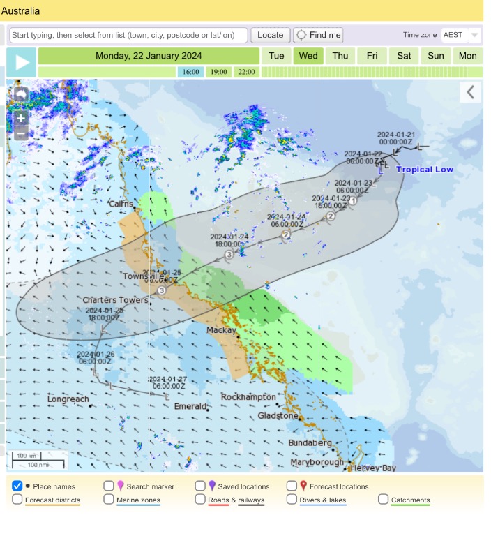 |
Colin Maitland. |
1 user thanked Colmait for this useful post.
|
|
|
|
Rank: Advanced Member
Groups: Registered, Administrators Joined: 21/08/2019(UTC) Posts: 942 Location: Brisbane Northside Thanks: 1198 times
Was thanked: 1136 time(s) in 674 post(s)
|
This mornings latest update PRIORITY TROPICAL CYCLONE ADVICE NUMBER 5 Issued at 5:53 am EST on Tuesday 23 January 2024 Headline: Tropical cyclone impact likely on the Queensland coast from Wednesday night. Areas Affected: Warning Zone None. Watch Zone Cairns to St Lawrence (not including Cairns), including Townsville, Mackay and the Whitsunday Islands.. Cancelled Zone None. Details of Tropical Low at 4:00 am AEST [3:30 am ACST]: Intensity: Tropical Low, sustained winds near the centre of 55 kilometres per hour with wind gusts to 85 kilometres per hour. Location: within 75 kilometres of 16.0 degrees South 153.9 degrees East, estimated to be 840 kilometres east northeast of Townsville and 420 kilometres east of Willis Island. Movement: slow moving. A tropical low (05U) has been developing slowly in the central Coral Sea and is expected to become a tropical cyclone overnight Tuesday or during Wednesday. This system is forecast to track southwest, towards the Queensland coast, over the next few days as it intensifies. The system is forecast to cross the Queensland coast most likely overnight Thursday between Cardwell and Airlie Beach. The chance of a severe tropical cyclone on landfall remains but has decreased. From Friday, the system is forecast to move further south over inland parts as a tropical low.  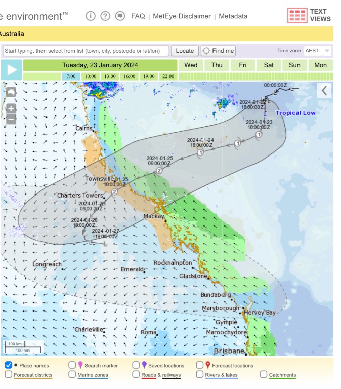 |
Colin Maitland. |
2 users thanked Colmait for this useful post.
|
|
|
|
Rank: Advanced Member
Groups: Registered, Administrators Joined: 21/08/2019(UTC) Posts: 942 Location: Brisbane Northside Thanks: 1198 times
Was thanked: 1136 time(s) in 674 post(s)
|
Satellite imagery of the low which is still looking a little scrappy on one hand while at the same time it is appearing to look like it is starting to develop into a Cyclone. Much more organised than yesterday. Using the Dvorak System or technique I would say the system is sitting between a T1.5 and T2.5. But we have a little bit to go before we would start to to see any eyewall development. I have downloaded JTWC’s positioning of the low onto google earth to give you a perspective of where the system currently sits.  The latest satellite imagery.    Edited by user Tuesday, 23 January 2024 1:57:47 PM(UTC)
| Reason: Had one one hand. LOL grammar |
Colin Maitland. |
1 user thanked Colmait for this useful post.
|
|
|
|
Rank: Advanced Member
Groups: Registered, Administrators Joined: 21/08/2019(UTC) Posts: 942 Location: Brisbane Northside Thanks: 1198 times
Was thanked: 1136 time(s) in 674 post(s)
|
PRIORITY TROPICAL CYCLONE ADVICE NUMBER 6 Issued at 11:10 am EST on Tuesday 23 January 2024 Headline: Tropical cyclone impacts likely to begin for coastal and Island communities from Wednesday afternoon. Areas Affected: Warning Zone None. Watch Zone Cairns to St Lawrence (not including Cairns), including Townsville, Mackay and the Whitsunday Islands . Cancelled Zone None. Details of Tropical Low at 10:00 am AEST [9:30 am ACST]: Intensity: Tropical Low, sustained winds near the centre of 65 kilometres per hour with wind gusts to 95 kilometres per hour. Location: within 35 kilometres of 16.3 degrees South 153.7 degrees East, estimated to be 800 kilometres east northeast of Townsville and 395 kilometres east of Willis Island. Movement: slow moving. A tropical low (05U) has been developing slowly in the central Coral Sea and is expected to become a tropical cyclone overnight Tuesday or early Wednesday. This system is forecast to track southwest, towards the Queensland coast, over the next few days as it intensifies. The system is likely to cross the Queensland coast late Thursday between Cardwell and Airlie Beach as a Category 3 system. In the longer term, the system is likely to track inland and south as a deep tropical low bringing heavy to intense rain to parts of central, western and southern Queensland.    |
Colin Maitland. |
2 users thanked Colmait for this useful post.
|
|
|
|
Rank: Advanced Member
Groups: Registered
Joined: 12/02/2020(UTC) Posts: 795 Location: Daintree Thanks: 1309 times
Was thanked: 1102 time(s) in 617 post(s)
|
Looking at the Willis radar it is very hard to reconcile that with that windy image above.
This one is really dragging it's heels and does not want to develop.
Cheers
|
|
2 users thanked FNQ Bunyip for this useful post.
|
|
|
|
Rank: Advanced Member
Groups: Registered, Administrators Joined: 21/08/2019(UTC) Posts: 942 Location: Brisbane Northside Thanks: 1198 times
Was thanked: 1136 time(s) in 674 post(s)
|
Originally Posted by: FNQ Bunyip 
Looking at the Willis radar it is very hard to reconcile that with that windy image above.
This one is really dragging it's heels and does not want to develop.
Cheers
Totally agree. The BoM’s Meteye has the Willis Island radar embedded into the track path and is part of the modelling system it uses. (Part of the real time they factor into the model). There is not a lot of cloud or rotation even when you expand out to 512K on the Willis Island Radar. Below is 512K Willis Island and the meteye to show much the same imagery.   The GFS model is only showing a HPa of 991, EC 996 and access 995 HPa. I would have expected to see that to be a lot lower by now. The system has been sitting out there for so long, I wonder how much fuel it has left. The water temps are hot but it needs to really start moving or it is doomed to become a cyclone. I believe they have even downgraded the strength of the system as it crosses, (if). I am more worried of a rain depression crossing and hugging the Coast and heading down this way. But all this can still change. This evening should tell us a lot more. |
Colin Maitland. |
1 user thanked Colmait for this useful post.
|
|
|
|
Rank: Advanced Member
Groups: Registered, Administrators Joined: 21/08/2019(UTC) Posts: 942 Location: Brisbane Northside Thanks: 1198 times
Was thanked: 1136 time(s) in 674 post(s)
|
So if this low forms into a cyclone, this will be Cyclone Kirrily 2. I was looking at JTWC for a few days and it kept coming up with Cyclone Kirrily, I thought that is a bit strange as usually it will be an invest 90 or something similar. So digging a bit deeper, it turns out that in 2000 there was a cyclone Kirrily of Western Australia and since it didn’t make any impact on the Australian Coast, or any other Island etc, the name has been able to used again.  Edited by user Tuesday, 23 January 2024 3:47:36 PM(UTC)
| Reason: Not specified |
Colin Maitland. |
3 users thanked Colmait for this useful post.
|
|
|
|
Rank: Advanced Member
Groups: Registered
Joined: 12/02/2020(UTC) Posts: 795 Location: Daintree Thanks: 1309 times
Was thanked: 1102 time(s) in 617 post(s)
|
I knew I'd heard the name before.
Good digging.
Cheers
|
|
2 users thanked FNQ Bunyip for this useful post.
|
|
|
|
Rank: Advanced Member
Groups: Registered
Joined: 27/08/2019(UTC) Posts: 1,110 Location: various, Cairns temporarily Thanks: 2619 times
Was thanked: 893 time(s) in 520 post(s)
|
Thank you Colmait for starting this thread, and saving all those screenshots to catch us up and to keep a record of the event. (Even if it remains a low.)
|
1 user thanked 28degrees for this useful post.
|
|
|
|
Rank: Advanced Member
Groups: Registered, Administrators Joined: 21/08/2019(UTC) Posts: 942 Location: Brisbane Northside Thanks: 1198 times
Was thanked: 1136 time(s) in 674 post(s)
|
Update for the Tropical Low this morning 24 January 2024. In a nutshell it is gained strength, may become a Cyclone this afternoon and is still travelling at 7 km/h. TOP PRIORITY FOR IMMEDIATE BROADCAST TROPICAL CYCLONE ADVICE NUMBER 11 Issued at 4:56 am EST on Wednesday 24 January 2024 Headline: Tropical cyclone impacts likely to begin for coastal and island communities Wednesday night. Areas Affected: Warning Zone Ayr to Mackay, including Mackay, Bowen and the Whitsunday Islands. Watch Zone Cairns to Ayr (not including Cairns), including Townsville and extending inland to Charters Towers. Mackay to St Lawrence. Cancelled Zone None. Details of Tropical Low at 4:00 am AEST: Intensity: Tropical Low, sustained winds near the centre of 75 kilometres per hour with wind gusts to 95 kilometres per hour. Location: within 65 kilometres of 17.2 degrees South 152.9 degrees East, estimated to be 690 kilometres east northeast of Townsville and 590 kilometres northeast of Mackay. Movement: west southwest at 7 kilometres per hour. A tropical low (05U) is developing slowly in the central Coral Sea and is expected to become a tropical cyclone later Wednesday. This system is forecast to track southwest towards the Queensland coast. The system is likely to cross the Queensland coast Thursday night between Cardwell and Bowen as a Category 2 system. In the longer term, the system is likely to track inland and south as a tropical low bringing heavy to intense rain to parts of central, western and southern Queensland.  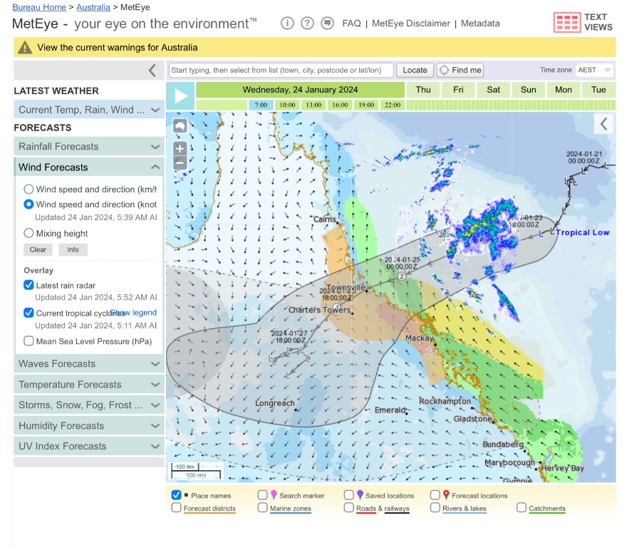  |
Colin Maitland. |
1 user thanked Colmait for this useful post.
|
|
|
|
Rank: Advanced Member
Groups: Registered, Administrators Joined: 21/08/2019(UTC) Posts: 942 Location: Brisbane Northside Thanks: 1198 times
Was thanked: 1136 time(s) in 674 post(s)
|
A comparison in track paths between BoM and JTWC ( overlayed onto google earth)   |
Colin Maitland. |
2 users thanked Colmait for this useful post.
|
|
|
|
Rank: Advanced Member
Groups: Registered
Joined: 12/02/2020(UTC) Posts: 795 Location: Daintree Thanks: 1309 times
Was thanked: 1102 time(s) in 617 post(s)
|
Well yes it is gaining some spin now but it really is dragging it's feet.
Backed off to a cat 2 on crossing now too.
I think the biggest threat is if it does the same as Jasper and comes ashore and just sits.
Maybe by this arvo we will see some real cyclone action.
Cheers
|
|
3 users thanked FNQ Bunyip for this useful post.
|
|
|
|
Rank: Advanced Member
Groups: Registered, Administrators Joined: 21/08/2019(UTC) Posts: 942 Location: Brisbane Northside Thanks: 1198 times
Was thanked: 1136 time(s) in 674 post(s)
|
It has to do something drastic because it is travelling at 7 km/h and has 690 Kilometres to reach where it is predicted to cross so that equates to 98 hours or approx 4 days. If it turns into a cyclone then it has to get going at an incredible speed to cross . It is predicted to cross in 39 hours. So it will have to travel at 18 hours Km/h from now to reach its forecast crossing. I know once they form and get the right steering winds they will move quickly. But still have to see what happens. They are throwing all sorts of numbers up for rain down here. 1.2 meters to 1.4 meters. While WATL has about 100mm . No one knows for sure what will happen. Hollywood Higgins is going for catastrophically biblical floods and telling his followers that the cyclone was going to form on last Sunday afternoon. Glad I don’t pay for that rubbish. But a slow moving rain depression is a worry even if it crossed as a cyclone. You guys up North coped a monumental amounts of rain. That is the worry for Townsville, inland and South of those areas or if it was to move North. ??? Edited by user Wednesday, 24 January 2024 7:15:39 AM(UTC)
| Reason: Bad at maths. |
Colin Maitland. |
3 users thanked Colmait for this useful post.
|
|
|
|
Weather Forum
»
Australia Weather
»
Tropical Lows and Cyclones
»
Tropical Low 05U-15 January / Cyclone Kirrily (24/01)/Ex Kirrily2024
Forum Jump
You cannot post new topics in this forum.
You cannot reply to topics in this forum.
You cannot delete your posts in this forum.
You cannot edit your posts in this forum.
You cannot create polls in this forum.
You cannot vote in polls in this forum.
Important Information:
The Weather Forum uses cookies. By continuing to browse this site, you are agreeing to our use of cookies.
More Details
Close
