Weather Forum
»
Australia Weather
»
SEQ and NE NSW
»
SE QLD and NE NSW - Day to Day Weather
Rank: Advanced Member
Groups: Registered
Joined: 21/08/2019(UTC) Posts: 185  Location: Ocean View Thanks: 359 times
Was thanked: 539 time(s) in 161 post(s)
|
We have just received a tiny sprinkle of rain here. No where near enough to register in a gauge, but the ground is damp, it smells wonderful and humidity shot up to 74%. 
|
 3 users thanked Pabloako for this useful post.
|
|
|
|
Rank: Advanced Member
Groups: Registered
Joined: 25/08/2019(UTC) Posts: 1,839 Location: Ferny Grove Thanks: 985 times
Was thanked: 856 time(s) in 419 post(s)
|
|
|
1 user thanked Falling_Droplet for this useful post.
|
|
|
|
Rank: Advanced Member
Groups: Registered
Joined: 13/09/2019(UTC)
Posts: 118
Location: Caboolture (the next Las Vegas!)
Thanks: 215 times
Was thanked: 297 time(s) in 100 post(s)
|
Originally Posted by: Zuldjan  Originally Posted by: DelBoy Originally Posted by: Zuldjan Spent overnight in Jimna, monitoring a fire there.
Apocalyptic is the words that come to mind - when your sitting in a valley, and everything around you is dark - or on fire.
Nasty images on TV. So are you a RFS volunteer? Yes. Excellent and thank you!. You guys and ladies need a medal for the things you do!  Edited by user Sunday, 10 November 2019 1:26:45 PM(UTC)
| Reason: Not specified
|
3 users thanked DelBoy for this useful post.
|
|
|
|
Rank: Advanced Member
Groups: Registered
Joined: 25/08/2019(UTC) Posts: 1,839 Location: Ferny Grove Thanks: 985 times
Was thanked: 856 time(s) in 419 post(s)
|
Ferny Grove Weather
Date: 10 Nov 2019
Time: 9:25 AM
Min Temp since 9am yesterday: 11.4 C
Max Temp since 9am yesterday: 31.8 C
Min Ground Temp: 26.3 C
Rain since 9am yesterday: 0 mm
Temperature: 26.3 C
Relative Humidity: 6 %
Dew Point: -14.2 C
MSL Pressure: 1014.1 hPa
Wind Speed: 12kph - gentle breeze
Wind Direction: NNW
Present Weather: Haze
Visibility: 10km to 19km - Good Visibility
Cloud Cover: 0/8
Ground State: Ground dry
Notes of yesterday weather - 9/11/19:
Fine and sunny. Smoke haze. A warm morning. The temperature was stable at around 30 C during most of the afternoon. Dew point rose in the early hours whilst remaining low before stabilising in the mid-morning then falling quickly from 10am. For 3 hrs from 1pm the dew point was stable at -20 C to -30 C before briefly rising very quickly at 4:20pm (including rising 35 C in 1 minute) and then stabilised at moderately low for the rest of the day. Relative humidity was low over the entire day with the overnight maximum being 25% before dropping back very low during the morning and falling to 1% for much of the afternoon. In the late afternoon the relative humidity rose very quickly (including a rise of 21% in 1 minute) becoming moderately low in the late morning. Light NNW to WNW winds early in the day, WNW to SW from the early morning with some NNW to WNW winds, NW to SW in the afternoon before shifting SE to ENE from late afternoon with the rise in humidity becoming calm later in the evening.
Today: A cold morning (a new record low again for November lowest temperature, old record was 11.5 C on the 6th this month). From 1am the dew point have been falling quite steadily and is extremely low. Likewise the relative humidity have been falling and is very low. Some N winds at times early today before NNW to WSW light winds since 6 am.
|
|
2 users thanked Falling_Droplet for this useful post.
|
|
|
|
Rank: Advanced Member
Groups: Registered
Joined: 21/08/2019(UTC) Posts: 185 Location: Ocean View Thanks: 359 times
Was thanked: 539 time(s) in 161 post(s)
|
GFS has a small but tiny glimmer of hope with increased humidity and possible showers and storms for next Saturday. Lots could change between now and then though. 
|
3 users thanked Pabloako for this useful post.
|
|
|
|
Rank: Advanced Member
Groups: Registered
Joined: 2/09/2019(UTC) Posts: 105 Location: Brisbane Thanks: 145 times
Was thanked: 561 time(s) in 103 post(s)
|
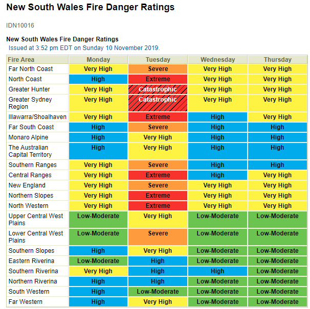 Speaking of fires, the preliminary forecast fire dangers for Tuesday have been updated to catastrophic for the Greater Hunter and Greater Sydney districts, with severe to extreme dangers in a number of other districts - see above. Speaking of fires, the preliminary forecast fire dangers for Tuesday have been updated to catastrophic for the Greater Hunter and Greater Sydney districts, with severe to extreme dangers in a number of other districts - see above.
|
5 users thanked Ken for this useful post.
|
|
|
|
Rank: Advanced Member
Groups: Registered
Joined: 21/08/2019(UTC) Posts: 35 Location: Toowoomba Thanks: 29 times
Was thanked: 120 time(s) in 33 post(s)
|
|
4 users thanked Skeetpete for this useful post.
|
|
|
|
Rank: Advanced Member
Groups: Registered
Joined: 21/08/2019(UTC) Posts: 185 Location: Ocean View Thanks: 359 times
Was thanked: 539 time(s) in 161 post(s)
|
Wow. They are very worrying levels for NSW. That sure is a concern. Here is the latest QLD forecasts.  Edited by user Sunday, 10 November 2019 5:43:39 PM(UTC)
| Reason: Not specified
|
4 users thanked Pabloako for this useful post.
|
|
|
|
Rank: Advanced Member
Groups: Registered
Joined: 25/08/2019(UTC) Posts: 1,839 Location: Ferny Grove Thanks: 985 times
Was thanked: 856 time(s) in 419 post(s)
|
Much warmer today with a maximum temperature of 34.4 C this afternoon. The dew point continued to fall from later in the morning after becoming steady in the mid morning at -15 C. In the afternoon the dew point was stable at -30 C. From 5 pm the dew point rose and quite quickly for about 5 minute at 6:30pm where is rose from -17 C to 0 C. Dew point is now 10 C. Relative humidity was also very low and continued to fall through the morning and became 1% for most of the afternoon. The relative humidity have been rising in the last 30 minutes and is now 41%. Light NNW to WNW winds mostly with some SW to WNW winds, W to NW winds in the afternoon with W to SW winds earlier in the afternoon and now been shifting to SE since 6:30pm. |
|
1 user thanked Falling_Droplet for this useful post.
|
|
|
|
Rank: Advanced Member
Groups: Registered
Joined: 25/08/2019(UTC) Posts: 1,839 Location: Ferny Grove Thanks: 985 times
Was thanked: 856 time(s) in 419 post(s)
|
|
|
1 user thanked Falling_Droplet for this useful post.
|
|
|
|
Rank: Advanced Member
Groups: Registered
Joined: 2/09/2019(UTC) Posts: 105 Location: Brisbane Thanks: 145 times
Was thanked: 561 time(s) in 103 post(s)
|
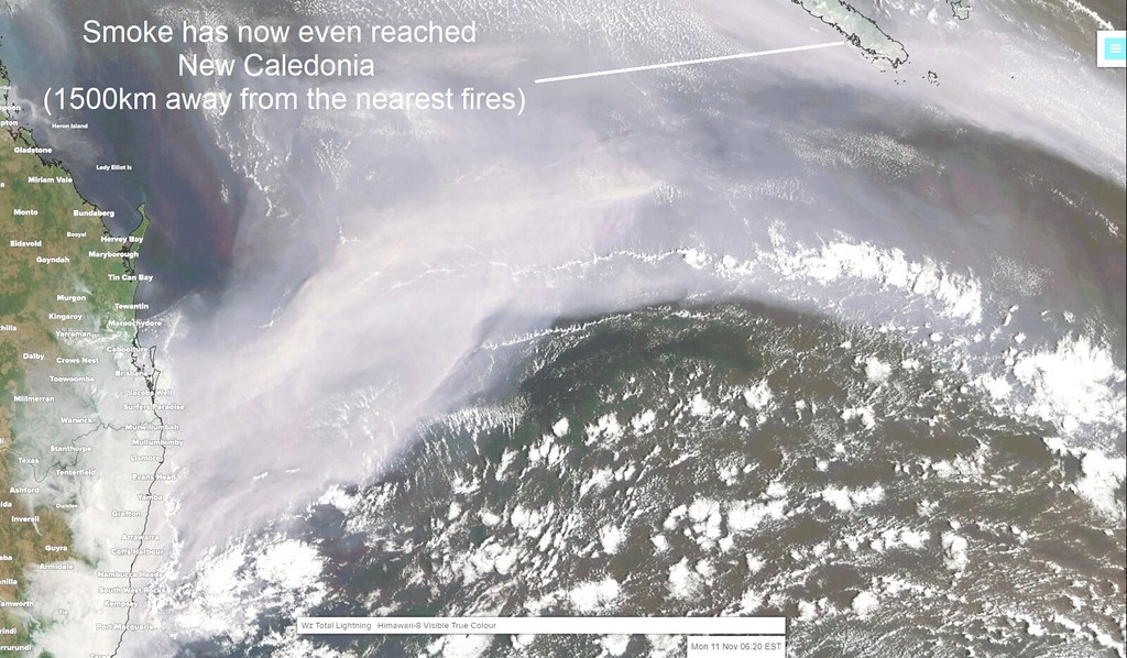 The smoke's now reached New Caledonia as well, 1500km away from the nearest fires. The smoke's now reached New Caledonia as well, 1500km away from the nearest fires.
I can’t help it wonder how strange it’d feel flying from here to New Caledonia for a holiday, only to find the very same-looking smoky skies when you arrive there.
|
6 users thanked Ken for this useful post.
|
|
|
|
Rank: Advanced Member
Groups: Registered
Joined: 21/08/2019(UTC) Posts: 185 Location: Ocean View Thanks: 359 times
Was thanked: 539 time(s) in 161 post(s)
|
Wow. That just goes to show the amazing amount of smoke and smoke particles that have been created from these fires, for it to get that far. There were a few news articles on Thursday last week of the smoke over Dunedin in NZ too.
|
4 users thanked Pabloako for this useful post.
|
|
|
|
Rank: Advanced Member
Groups: Registered
Joined: 21/08/2019(UTC) Posts: 182 Location: Wynnum North Thanks: 656 times
Was thanked: 381 time(s) in 167 post(s)
|
WYNNUM NORTH ( 27.4S 153.2E ) - WEATHER
DATE...11 NOV 2019 TIME....0735
CURRENT TEMPERATURE...22.2C
CURRENT HUMIDITY........65%
CURRENT DEW POINT.......15C
CURRENT WIND DIR/SPEED..SSE 5Kph
CURRENT VISIBILITY.....3000M
CURRENT MSL PRESSURE...1017.6Hpa
CURRENT CLOUD..........4/8 Sc, 4/8 Ac
CURRENT WEATHER...Thick smoke haze
RAIN SINCE 0900 SUNDAY...0.0mm
SUMMARY LAST 24 HOURS
YESTERDAY'S MAX TEMP. .......28.5C
THIS MORNING'S MIN TEMP......15.8C
PAST 24 HOURS TEMP ANOMALY..-0.80C
THIS MORNING'S GRASS MIN.....13.8C
AVERAGE 24 HOUR DEW POINT.......7C
AVERAGE 24 HOUR MSLP........1013.4Hpa
MAX WIND GUST LAST 24 HOURS...NE 31Kph at 1422
PAST 24 HR SIGNIFICANT WEATHER...Thickening smoke haze. |
Wyn Nth 2020-Jan165, |
1 user thanked retired weather man for this useful post.
|
|
|
|
Rank: Advanced Member
Groups: Registered
Joined: 25/08/2019(UTC) Posts: 1,839 Location: Ferny Grove Thanks: 985 times
Was thanked: 856 time(s) in 419 post(s)
|
Ferny Grove Weather
Date: 11 Nov 2019
Time: 7:35 AM
Min Temp since 9am yesterday: 16.3 C
Max Temp since 9am yesterday: 34.4 C
Min Ground Temp: 14 C
Rain since 9am yesterday: 0 mm
Temperature: 22.1 C
Relative Humidity: 50 %
Dew Point: 10.9 C
MSL Pressure: 1017.4 hPa
Wind Speed: 3 kph - light air
Wind Direction: SW
Present Weather: Haze
Visibility: 2000m to 3999m - Poor Visibility
Cloud Cover: 0/8
Ground State: Ground dry
Notes of yesterday weather - 10/11/19: Fine and sunny with smoke haze. A cold morning and a warm day. The dew point fell from moderately low early in the day becoming very low from the early morning stabilising at around -15 C in the late morning. In the early afternoon the dew point fell further and became stable at -30 C until 5pm. The dew point then rose returning to moderately low in the evening and became stable. The dew point rose from -17 C to 0 C in 5 minutes at 6:30pm. Relative humidity fell from very early in the day becoming very low from the early morning. The relative humidity continued to fall through the morning and fell to 1% in the afternoon for several hours. From 6:30pm the relative humidity rose before rising more slowly from 7:30pm and was moderately low. Some light N winds early with NNW to WNW winds from early morning with some SW to WSW winds, WSW to NW in the early afternoon, W to NW winds from mid afternoon before shifting to S to SE from 6:30pm and S to SW for the rest of the evening.
Today: Thickening smoke haze. The dew point have been stable and moderately low. Low overnight relative humidity. Calm winds early in the day with some SW winds with S to SSW winds since 6am.
|
|
1 user thanked Falling_Droplet for this useful post.
|
|
|
|
Rank: Advanced Member
Groups: Registered
Joined: 2/09/2019(UTC) Posts: 105 Location: Brisbane Thanks: 145 times
Was thanked: 561 time(s) in 103 post(s)
|
The current and recent smoke is the worst I can recall in my years of living here in terms of its sheer frequency, persistence, and geographical extent. The Black Saturday fires were nightmarish in every single aspect but its fires and smoke had much less geographical extent and reach than the current ones. The light winds and stable atmosphere caused by the high haven't been helping things this morning here.
I suspect the smoke might decrease somewhat on Tuesday with the NW'lies kicking in but there still appears to be the possibility (but definitely not a certainty) that this Wednesday may see some further smoke haze near the surface reaching sections of SE QLD yet again from the NSW fires due to the S to SE wind change pushing up the coast….. as well as the outside chance of some dust haze again from inland dust storms.
It also depends on how much any SE QLD fires will add to the smoke.
If any further smoke haze does manage to reach us on Wed, the majority of it will probably be from the lower part of the smoke plumes in NSW as the S to SE coastal wind change pushes up the coast, while most of the smoke in their mid and upper parts will probably keep getting dragged out to sea by the strong upper level NW to SW winds.
This also partly depends on whether any large fires start around central parts of the NSW coast and adjacent inland in addition to the existing fires.
But the lingering smoke looks more certain along much of the northern half of the NSW coast because a number of fires are a bit inland of the coast, meaning much of the smoke will likely keep getting dragged over the coast as it heads out to sea.
Here's a forecast loop of surface smoke concentrations for the next few days predicted by the US Navy’s Aerosol Analysis and Prediction System: https://www.youtube.com/watch?v=...ZlE&feature=youtu.be
A couple of important caveats though - these maps won’t necessarily show concentrations further up in the air.... and it's based on current fires so if any of these fires change weaken or intensify, or new ones develop, the forecast smoke shown on this map will also change.
Mid or late this week still looks to have the prospect of some shower or severe thunderstorm activity (moreso the weekend) in this local area but any rainfall amounts look fairly modest, and they look more like being brief interruptions to the ongoing dry weather rather than a dominant weather condition.Edited by user Monday, 11 November 2019 1:56:07 PM(UTC)
| Reason: Not specified
|
4 users thanked Ken for this useful post.
|
|
|
|
Rank: Member
Groups: Registered
Joined: 17/08/2019(UTC) Posts: 11 Location: Brisbane Was thanked: 26 time(s) in 9 post(s)
|
Originally Posted by: Ken The current and recent smoke is the worst I can recall in my years of living here in terms of its sheer frequency, persistence, and geographical extent. The Black Saturday fires were nightmarish in every single aspect but its fires and smoke had much less geographical extent and reach than the current ones. The light winds and stable atmosphere caused by the high haven't been helping things this morning here.
I suspect the smoke might decrease somewhat on Tuesday with the NW'lies kicking in but there still appears to be the possibility (but definitely not a certainty) that this Wednesday may see some further smoke haze near the surface reaching sections of SE QLD yet again from the NSW fires due to the S to SE wind change pushing up the coast….. as well as the outside chance of some dust haze again from inland dust storms.
It also depends on how much any SE QLD fires will add to the smoke.
If any further smoke haze does manage to reach us on Wed, the majority of it will probably be from the lower part of the smoke plumes in NSW as the S to SE coastal wind change pushes up the coast, while most of the smoke in their mid and upper parts will probably keep getting dragged out to sea by the strong upper level NW to SW winds.
This also partly depends on whether any large fires start around central parts of the NSW coast and adjacent inland in addition to the existing fires.
But the lingering smoke looks more certain along much of the northern half of the NSW coast because a number of fires are a bit inland of the coast, meaning much of the smoke will likely keep getting dragged over the coast as it heads out to sea.
Here's a forecast loop of surface smoke concentrations for the next few days predicted by the US Navy’s Aerosol Analysis and Prediction System: https://www.youtube.com/watch?v=...ZlE&feature=youtu.be
A couple of important caveats though - these maps won’t necessarily show concentrations further up in the air.... and it's based on current fires so if any of these fires change weaken or intensify, or new ones develop, the forecast smoke shown on this map will also change.
Mid or late this week still looks to have the prospect of some shower or severe thunderstorm activity (moreso the weekend) in this local area but any rainfall amounts look fairly modest, and they look more like being brief interruptions to the ongoing dry weather rather than a dominant weather condition. Any chance of the current catastrophic conditions in NSW to move further north into SEQ?.
|
2 users thanked Zuldjan for this useful post.
|
|
|
|
Rank: Advanced Member
Groups: Registered
Joined: 25/08/2019(UTC) Posts: 1,839 Location: Ferny Grove Thanks: 985 times
Was thanked: 856 time(s) in 419 post(s)
|
Very thick smoke haze in Brisbane with visibility down to 1km during the middle of the day and improved to 3km by later in the afternoon. The temperature was variable in the morning and afternoon and was close to average. Dew point have remained near average, has been steadily rising since the morning and is now 14 C. Near average relative humidity today which fell to a low of 36% and is now 58%. Light E to SE winds from 8am this morning, becoming NE to ESE and E to NE from 2pm. |
|
1 user thanked Falling_Droplet for this useful post.
|
|
|
|
Rank: Advanced Member
Groups: Registered
Joined: 25/08/2019(UTC) Posts: 1,839 Location: Ferny Grove Thanks: 985 times
Was thanked: 856 time(s) in 419 post(s)
|
|
|
1 user thanked Falling_Droplet for this useful post.
|
|
|
|
Rank: Advanced Member
Groups: Registered
Joined: 2/09/2019(UTC) Posts: 105 Location: Brisbane Thanks: 145 times
Was thanked: 561 time(s) in 103 post(s)
|
Originally Posted by: Zuldjan Originally Posted by: Ken The current and recent smoke is the worst I can recall in my years of living here in terms of its sheer frequency, persistence, and geographical extent. The Black Saturday fires were nightmarish in every single aspect but its fires and smoke had much less geographical extent and reach than the current ones. The light winds and stable atmosphere caused by the high haven't been helping things this morning here.
I suspect the smoke might decrease somewhat on Tuesday with the NW'lies kicking in but there still appears to be the possibility (but definitely not a certainty) that this Wednesday may see some further smoke haze near the surface reaching sections of SE QLD yet again from the NSW fires due to the S to SE wind change pushing up the coast….. as well as the outside chance of some dust haze again from inland dust storms.
It also depends on how much any SE QLD fires will add to the smoke.
If any further smoke haze does manage to reach us on Wed, the majority of it will probably be from the lower part of the smoke plumes in NSW as the S to SE coastal wind change pushes up the coast, while most of the smoke in their mid and upper parts will probably keep getting dragged out to sea by the strong upper level NW to SW winds.
This also partly depends on whether any large fires start around central parts of the NSW coast and adjacent inland in addition to the existing fires.
But the lingering smoke looks more certain along much of the northern half of the NSW coast because a number of fires are a bit inland of the coast, meaning much of the smoke will likely keep getting dragged over the coast as it heads out to sea.
Here's a forecast loop of surface smoke concentrations for the next few days predicted by the US Navy’s Aerosol Analysis and Prediction System: https://www.youtube.com/watch?v=...ZlE&feature=youtu.be
A couple of important caveats though - these maps won’t necessarily show concentrations further up in the air.... and it's based on current fires so if any of these fires change weaken or intensify, or new ones develop, the forecast smoke shown on this map will also change.
Mid or late this week still looks to have the prospect of some shower or severe thunderstorm activity (moreso the weekend) in this local area but any rainfall amounts look fairly modest, and they look more like being brief interruptions to the ongoing dry weather rather than a dominant weather condition. Any chance of the current catastrophic conditions in NSW to move further north into SEQ?. Nah not really. But they will still be bad, and conducive to the rapid spread of any existing or new fires.
|
1 user thanked Ken for this useful post.
|
|
|
|
Rank: Advanced Member
Groups: Registered
Joined: 25/08/2019(UTC) Posts: 1,839 Location: Ferny Grove Thanks: 985 times
Was thanked: 856 time(s) in 419 post(s)
|
Ferny Grove Weather
Date: 12 Nov 2019
Time: 7:45 AM
Min Temp since 9am yesterday: 15.4 C
Max Temp since 9am yesterday: 28.7 C
Min Ground Temp: 13.6 C
Rain since 9am yesterday: 0 mm
Temperature: 23.9 C
Relative Humidity: 64 %
Dew Point: 16.7 C
MSL Pressure: 1017 hPa
Wind Speed: 12 kph - light breeze
Wind Direction: SSW
Present Weather: Haze
Visibility: 10km to 19km - Good Visibility
Cloud Cover: 0/8
Ground State: Ground dry
Notes of yesterday weather - 11/11/19: Fine. Very thick smoke haze. Some cu clouds during the day. A cool morning. Variable temperature in the morning and afternoon. The dew point was stable and moderately low early in the day, before rising from the morning close to average. Low relative humidity and near average during the day and in the evening. Calm winds early, before S to SW winds from the early morning, E to SE winds from 8am and NE to ESE form 9am, ESE to NE from 10am, E to NE from 2pm, N to NE in the evening and calm later in the evening.
Today: A cool morning. Dew point have been near average today and have been rising for the last few hours. Relative humidity have been near average. Calm winds overnight and light N to NE winds developing in the last hour.
|
|
1 user thanked Falling_Droplet for this useful post.
|
|
|
|
Weather Forum
»
Australia Weather
»
SEQ and NE NSW
»
SE QLD and NE NSW - Day to Day Weather
Forum Jump
You cannot post new topics in this forum.
You cannot reply to topics in this forum.
You cannot delete your posts in this forum.
You cannot edit your posts in this forum.
You cannot create polls in this forum.
You cannot vote in polls in this forum.
Important Information:
The Weather Forum uses cookies. By continuing to browse this site, you are agreeing to our use of cookies.
More Details
Close
