Weather Forum
»
Australia Weather
»
SEQ and NE NSW
»
SE QLD and NE NSW - Day to Day Weather
Rank: Administration
Groups: Administrators
Joined: 9/08/2019(UTC)
Posts: 70
Thanks: 151 times
Was thanked: 98 time(s) in 41 post(s)
|
Welcome - If you see a big green blob below, that is because we are so new, the paint isn't dry yet and Google have't activated the adverts. To help fund the cost of the site, the second post on each page will be a small advert and that is it. (I can't stand adverts on websites) Edited by user Sunday, 25 August 2019 7:18:53 AM(UTC)
| Reason: Not specified
|
|
|
|
|
|
Rank: Advanced Member
Groups: Registered, Administrators Joined: 21/08/2019(UTC) Posts: 941  Location: Brisbane Northside Thanks: 1198 times
Was thanked: 1136 time(s) in 674 post(s)
|
Hi all. A cool windy start to Wed. Morning but an awesome sunrise due to the dust particles. By the looks of everything the dry is set to continue but we could see a small shower or 2 over the next week if the models are correct. Edited by user Wednesday, 21 August 2019 6:28:10 AM(UTC)
| Reason: Trying the features out. |
Colin Maitland. |
|
|
|
|
|
Rank: Advanced Member
Groups: Registered
Joined: 21/08/2019(UTC) Posts: 182 Location: Wynnum North Thanks: 656 times
Was thanked: 381 time(s) in 167 post(s)
|
I have been invited to join this forum. I had also been invited to join 4 other forums after the closure of WZ, but it seems I was the only one there after nearly 2 months of posts, so have given them away. I hope this one is a bit more productive. So here is a copy of todays daily weather report from my station ( manually read and put together )…
WYNNUM NORTH ( 27.4S 153.2E ) - WEATHER
DATE....21 AUG 2019...TIME...0730
CURRENT TEMPERATURE...12.4C
CURRENT HUMIDITY........52%
CURRENT DEW POINT........3C
CURRENT WIND SPEED/DIR...WNW 1Kph
CURRENT MSL PRESSURE...1020.7Hpa
CURRENT VISIBILITY......40Km
CURRENT CLOUD..........Nil
CURRENT WEATHER......No signifcant weather
RAIN SINCE 0900 TUESDAY..0.0mm.
SUMMARY LAST 24 HOURS ......20.9C
THIS MORNING'S MIN TEMP......5.0C ( Coldest morning of the year )
PAST 24 HOUR TEMP.ANOMALY..-3.35C
THIS MORNING'S GRASS MIN.....3.1C
AVERAGE 24 HOUR DEW POINT......2C
AVERAGE 24 HOUR MSLP.......1022.8Hpa
MAX WIND GUST LAST 24 HOURS..W 23Kph at 1156
PAST 24 HR SIGNIFICANT WEATHER..No significant weather. |
Wyn Nth 2020-Jan165, |
|
|
|
|
|
Rank: Advanced Member
Groups: Registered
Joined: 21/08/2019(UTC) Posts: 185 Location: Ocean View Thanks: 359 times
Was thanked: 539 time(s) in 161 post(s)
|
Originally Posted by: retired weatber man  I have been invited to join this forum. I had also been invited to join 4 other forums after the closure of WZ, but it seems I was the only one there after nearly 2 months of posts, so have given them away. Hi Retired Weather man and thanks for joining this one. There are only up to 24 users subscribed so far, but we only opened it up last night after testing. We have sent PMs to quite a few old WZ users and we are also about to pay for Google Adverts to get the site noticed. It is always hard to start new forums, because without people posting, others do not join and with out people joining, we do not get new posts. We have gone a bit crazy with the setup of the forum and our load testing has shown we can get over 60,000 posting and browsing at the same time, so it should (touch wood) keep working during multiple major events. If you (or anyone else) has any requests for the site, let me know and we will do our best to make it happen. In the mean time, let people you know that we exist and we can build the user base up. Enjoy the weather! 
|
 1 user thanked Pabloako for this useful post.
|
|
|
|
Rank: Administration
Groups: Administrators
Joined: 9/08/2019(UTC)
Posts: 70
Thanks: 151 times
Was thanked: 98 time(s) in 41 post(s)
|
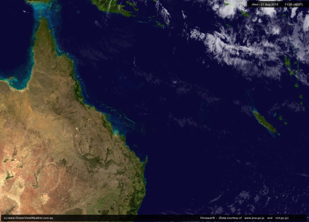 Not a cloud in the sky over QLD! Winter time here really is wonderful. (Unless you want rain of course)
|
|
|
|
|
|
Rank: Advanced Member
Groups: Registered, Administrators Joined: 21/08/2019(UTC) Posts: 941 Location: Brisbane Northside Thanks: 1198 times
Was thanked: 1136 time(s) in 674 post(s)
|
Could see a massive plume of smoke to the North today. 9 news article said A camping ground has been evacuated due to a bushfire on Bribie Island, off Brisbane. The fire began as a planned burn but is now burning out of control on the northern end of the island. Queensland Fire and Emergency Services said it poses no threat to property. https://www.9news.com.au...a-4794-b036-06ac0ae52f74Cheers Colin. |
Colin Maitland. |
|
|
|
|
|
Rank: Advanced Member
Groups: Registered
Joined: 21/08/2019(UTC) Posts: 185 Location: Ocean View Thanks: 359 times
Was thanked: 539 time(s) in 161 post(s)
|
I can see a huge orange glow over central Bribie from up here in Ocean View. Looks like the main fire front is towards the southern end and then there looks like there are multiple smaller fires towards the north.
|
|
|
|
|
|
Rank: Advanced Member
Groups: Registered
Joined: 21/08/2019(UTC) Posts: 182 Location: Wynnum North Thanks: 656 times
Was thanked: 381 time(s) in 167 post(s)
|
WYNNUM NORTH ( 27.4S 153.2E ) - WEATHER
DATE....22 AUG 2019...TIME...0740
CURRENT TEMPERATURE...15.0C
CURRENT HUMIDITY........53%
CURRENT DEW POINT........6C
CURRENT WIND SPEED/DIR...W 17Kph
CURRENT MSL PRESSURE...1016.0Hpa
CURRENT VISIBILITY......40Km
CURRENT CLOUD..........Nil
CURRENT WEATHER......No signifcant weather
RAIN SINCE 0900 WEDNESDAY..0.0mm.
SUMMARY LAST 24 HOURS ......25.2C
THIS MORNING'S MIN TEMP......9.0C
PAST 24 HOUR TEMP.ANOMALY..+0.80C
THIS MORNING'S GRASS MIN.....5.0C
AVERAGE 24 HOUR DEW POINT......3C
AVERAGE 24 HOUR MSLP.......1017.8Hpa
MAX WIND GUST LAST 24 HOURS..W 41Kph at 1325
PAST 24 HR SIGNIFICANT WEATHER..No significant weather. |
Wyn Nth 2020-Jan165, |
|
|
|
|
|
Rank: Advanced Member
Groups: Registered
Joined: 21/08/2019(UTC) Posts: 182 Location: Wynnum North Thanks: 656 times
Was thanked: 381 time(s) in 167 post(s)
|
To Admin, thanks for making the change to my sign in. |
Wyn Nth 2020-Jan165, |
|
|
|
|
|
Rank: Advanced Member
Groups: Registered
Joined: 21/08/2019(UTC) Posts: 35 Location: Toowoomba Thanks: 29 times
Was thanked: 120 time(s) in 33 post(s)
|
Same old boring weather day in and day out.Gusting up to 50kms and cold.Not looking good for rain.Whatever grass there is its crispy when walking on it.Probably need 2 falls of 100mm at least to soak the ground before any runs off.Anyway it's gotta change some time soon hopefully from October.
|
|
|
|
|
|
Rank: Advanced Member
Groups: Registered, Administrators Joined: 21/08/2019(UTC) Posts: 941 Location: Brisbane Northside Thanks: 1198 times
Was thanked: 1136 time(s) in 674 post(s)
|
Yeah winds are gusting over 60km/h here. Getting stronger as the day goes on. Toowoomba and Warwick are copping stronger winds. There has to dust coming in soon with all this wind. |
Colin Maitland. |
|
|
|
|
|
Rank: Advanced Member
Groups: Registered
Joined: 21/08/2019(UTC) Posts: 185 Location: Ocean View Thanks: 359 times
Was thanked: 539 time(s) in 161 post(s)
|
Same here. The wind is averaging 15-20kts with gusts over 30kts from the South West My poor banana plants have had their leaves stripped. 
|
|
|
|
|
|
Rank: Advanced Member
Groups: Registered
Joined: 21/08/2019(UTC) Posts: 182 Location: Wynnum North Thanks: 656 times
Was thanked: 381 time(s) in 167 post(s)
|
Max gust Wynnum North today W 59Kph at 1415.
|
Wyn Nth 2020-Jan165, |
|
|
|
|
|
Rank: Advanced Member
Groups: Registered
Joined: 21/08/2019(UTC) Posts: 185 Location: Ocean View Thanks: 359 times
Was thanked: 539 time(s) in 161 post(s)
|
Quite an interesting wind change in the night. At 11:20pm, the wind changed from SW and blowing at 20ks to southerly and less than 5kts for the rest of the night. It was even accompanied by a tiny shower of rain, which I wasn't expecting. I even went out to see if a hose pipe had burst and water was hitting the side of the house, bit it was actually rain! 0.2mm all up. 
|
|
|
|
|
|
Rank: Advanced Member
Groups: Registered
Joined: 21/08/2019(UTC) Posts: 182 Location: Wynnum North Thanks: 656 times
Was thanked: 381 time(s) in 167 post(s)
|
WYNNUM NORTH ( 27.4S 153.2E ) - WEATHER
DATE....23 AUG 2019...TIME...0750
CURRENT TEMPERATURE...14.3C
CURRENT HUMIDITY........66%
CURRENT DEW POINT........8C
CURRENT WIND SPEED/DIR...WSW 13Kph
CURRENT MSL PRESSURE...1024.0Hpa
CURRENT VISIBILITY......25Km
CURRENT CLOUD..........2/8 Sc, decreasing.
CURRENT WEATHER......Smoke haze
RAIN SINCE 0900 THURSDAY..0.0mm.
SUMMARY LAST 24 HOURS ......25.1C
THIS MORNING'S MIN TEMP.....10.0C
PAST 24 HOUR TEMP.ANOMALY..+1.25C
THIS MORNING'S GRASS MIN.....8.1C
AVERAGE 24 HOUR DEW POINT......8C
AVERAGE 24 HOUR MSLP.......1016.9Hpa
MAX WIND GUST LAST 24 HOURS..W 59Kph at 1415
PAST 24 HR SIGNIFICANT WEATHER..Smoke haze developed. |
Wyn Nth 2020-Jan165, |
|
|
|
|
|
Rank: Advanced Member
Groups: Registered, Administrators Joined: 21/08/2019(UTC) Posts: 941 Location: Brisbane Northside Thanks: 1198 times
Was thanked: 1136 time(s) in 674 post(s)
|
A strange night here last night. Even though temps suggested it was cooler it felt rather warm and muggy.
The southerly has pushed its way up the coast and the Brisbane Wave Rider Buoy recorded a Hmax of 8 meters just before midday.
Also bush fires threatened residents at Narangba, they were placed on watch and act. In Noosa the fire near the Golf Course came within meters of houses. Fortunately the change helped the situation a little.
The next week still looks grim with only a slight possibility of scattered showers and maybe a total of 4 mm’s.
Although it is not part of this thread it was of interest that Cairns recorded a frost for the first time in 60 years this morning. |
Colin Maitland. |
|
|
|
|
|
Rank: Advanced Member
Groups: Registered
Joined: 21/08/2019(UTC) Posts: 182 Location: Wynnum North Thanks: 656 times
Was thanked: 381 time(s) in 167 post(s)
|
Somewhat surprising about a frost in Cairns itself, as its min this morning was 7.9C. The lowest air temp for a possible frost is 2C. Maybe up on the Tablelands, but not Cairns with a temp like that. |
Wyn Nth 2020-Jan165, |
|
|
|
|
|
Rank: Advanced Member
Groups: Registered
Joined: 21/08/2019(UTC) Posts: 185 Location: Ocean View Thanks: 359 times
Was thanked: 539 time(s) in 161 post(s)
|
I spoke to a customer in Port Douglas today and he said it was cold there this morning. He said the heater on his car has been broken for years and only the air con works and it was a horrible drive to work today. For down in this part of the state, it looks like we have a few lovely warm days into next week, in the mid 20s and sunshine. Fingers crossed for a drop of rain on Wednesday. Edited by user Friday, 23 August 2019 6:09:02 PM(UTC)
| Reason: Not specified
|
|
|
|
|
|
Rank: Advanced Member
Groups: Registered
Joined: 23/08/2019(UTC) Posts: 155 Location: Narangba Thanks: 280 times
Was thanked: 442 time(s) in 136 post(s)
|
Howdy Everyone and it is nice to see a fresh new forum,
I am just off of Alf Dobson Road in Narangba and had a bit of a worrying evening yesterday. The RFS were excellent and lots of people were offering to help evacuate the cats from the local cattery. Luckily the fire stayed to the south and was mostly out before the southerly change came though, so it wasn't needed, but it was great to see everyone come together. Big thumbs up to everyone!
|
|
|
|
|
|
Rank: Newbie
Groups: Registered
Joined: 23/08/2019(UTC) Posts: 9 Location: Burrum Heads Thanks: 20 times
Was thanked: 26 time(s) in 8 post(s)
|
Woke up to a surprising light drizzle this morning. I doubt it will even show in the rain gauge but it might settle the dust a bit.
Glad all is ok with you and the cats CSNarangba.
|
1 user thanked Pharbelle for this useful post.
|
|
|
|
Weather Forum
»
Australia Weather
»
SEQ and NE NSW
»
SE QLD and NE NSW - Day to Day Weather
Forum Jump
You cannot post new topics in this forum.
You cannot reply to topics in this forum.
You cannot delete your posts in this forum.
You cannot edit your posts in this forum.
You cannot create polls in this forum.
You cannot vote in polls in this forum.
Important Information:
The Weather Forum uses cookies. By continuing to browse this site, you are agreeing to our use of cookies.
More Details
Close
