Weather Forum
»
Australia Weather
»
SEQ and NE NSW
»
SE QLD and NE NSW - Day to day Weather 2024
Rank: Advanced Member
Groups: Registered, Administrators Joined: 21/08/2019(UTC) Posts: 941  Location: Brisbane Northside Thanks: 1198 times
Was thanked: 1136 time(s) in 674 post(s)
|
A new thread opened for the 2024 calendar year day to day general weather discussion. |
Colin Maitland. |
|
|
|
|
|
Rank: Advanced Member
Groups: Registered, Administrators Joined: 21/08/2019(UTC) Posts: 941 Location: Brisbane Northside Thanks: 1198 times
Was thanked: 1136 time(s) in 674 post(s)
|
Well we are of to a unbelievable wet start to 2024 and what a way to start a new Day to Day weather chat thread. Some of the rain totals, especially down the Gold Coast and Hinterland regions have recorded massive rain totals. A flood watch has been issued for Upper and Lower Brisbane River.Albert and Logan rivers, and Gold Coast Rivers and Creeks.    |
Colin Maitland. |
|
|
|
|
|
Rank: Advanced Member
Groups: Registered, Administrators Joined: 21/08/2019(UTC) Posts: 941 Location: Brisbane Northside Thanks: 1198 times
Was thanked: 1136 time(s) in 674 post(s)
|
Latest STW 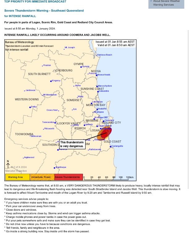 |
Colin Maitland. |
|
|
|
|
|
Rank: Advanced Member
Groups: Registered, Administrators Joined: 21/08/2019(UTC) Posts: 941 Location: Brisbane Northside Thanks: 1198 times
Was thanked: 1136 time(s) in 674 post(s)
|
The Mt Stapylton 24 hour rain rates. Incredible.  Metropolitan totals around Brisbane  Queensland Totals as at 0955  |
Colin Maitland. |
|
|
|
|
|
Rank: Advanced Member
Groups: Registered, Administrators Joined: 21/08/2019(UTC) Posts: 941 Location: Brisbane Northside Thanks: 1198 times
Was thanked: 1136 time(s) in 674 post(s)
|
 https://www.abc.net.au/n...-new-years-day/103276844 https://www.abc.net.au/n...-new-years-day/103276844A severe weather warning has been issued for the already-battered Gold Coast and Scenic Rim areas, with the Bureau of Meteorology warning of localised intense rainfall and the possibility of life-threatening flash flooding on New Year's Day. Large parts of Queensland's south-east are on alert for heavy rain from a slow-moving thunderstorm, with isolated 24-hourly rainfall totals of more than 250 millimetres possible. The Bureau has extended its warning area as far north as Gympie. Upper Springbrook copped 389mm of rain in 24 hours to 9am on New Year's Day, while Wongawallan recorded 119mm in just two hours. Little Nerang Dam recorded 276mm in 24 hours, with 264mm falling at Hotham Creek near Pimpama and 215mm at Binna Burra.  Scenic Rim Mayor Greg Christensen encouraged residents to shelter in place, with several roads in the council area closed due to flooding. "It's clear that there will be instability from such an intense event," he said. "That just runs the risk of more things coming down, landslips coming down, we don't want people caught in dangerous places because that just creates another need for a response." Queensland Fire and Emergency Services (QFES) have already been called to "multiple flood-related incidents" today. Flood warnings have been issued for the Nerang and Coomera Rivers, with creek level rises also observed around the Mudgeeraba, Tallebudgera and Currumbin Creeks. The Bureau predicts rapid rises will continue for the Pimpama, Nerang and Coomera Rivers during periods of intense rainfall, which are forecast to continue for the next day or two. .  |
Colin Maitland. |
|
|
|
|
|
Rank: Advanced Member
Groups: Registered, Administrators Joined: 21/08/2019(UTC) Posts: 941 Location: Brisbane Northside Thanks: 1198 times
Was thanked: 1136 time(s) in 674 post(s)
|
2 January and the severe weather event is still affecting SE Qld and NE NSW.. The trough associated with this system is expected to move slowly eastwards and off the coast tonight. Rainfall totals of between 200 -300 mm are once again predicted. For more information please see the event thread for this dangerous system. https://www.weatherforum...-2-January-2024#post7903Please stay safe. |
Colin Maitland. |
|
|
|
|
|
Rank: Advanced Member
Groups: Registered, Administrators Joined: 21/08/2019(UTC) Posts: 941 Location: Brisbane Northside Thanks: 1198 times
Was thanked: 1136 time(s) in 674 post(s)
|
A bit of normality has returned to our weather. I hope everyone pulled through OK or if you were impacted by the devastation I hope you are all getting the help that is needed.
The weather is looking more like scattered showers although BoM have stated possible storms over the next few days. The modelling system for the rest of this week appears to only show the possibility ( slim) of maybe just weak thundery storms. Nothing big or severe is showing up at this stage. On the weekend there is more of a chance for storms but not real severe at this stage and if they get organised. Next week could see some slightly bigger storms but it is a bit too far out to call it. Just need to check the modelling each day and see how everything pans out.
|
Colin Maitland. |
|
|
|
|
|
Rank: Advanced Member
Groups: Registered, Administrators Joined: 21/08/2019(UTC) Posts: 941 Location: Brisbane Northside Thanks: 1198 times
Was thanked: 1136 time(s) in 674 post(s)
|
|
Colin Maitland. |
|
|
|
|
|
Rank: Advanced Member
Groups: Registered, Administrators Joined: 21/08/2019(UTC) Posts: 941 Location: Brisbane Northside Thanks: 1198 times
Was thanked: 1136 time(s) in 674 post(s)
|
Friday 5 January 2024. The models are pointing to widespread showers with possible storms. At this stage storms are not expected to be severe. In saying that there is still a slight chance of the odd cell or two that could go against the trend. This would be the inland Southern interior and possibly in the SEQLD and NE NSW area and the reason for saying this is due to the storm system that lashed Sydney yesterday and surrounds is expected to move forward in Northerly direction into those areas. But going from the modelling systems, they are not picking up severe storms at this stage. TotalTotals (TT’s) at this stage have a value of 43. This indicates isolated weak storms, unlike the TT’s of 56 last week that saw destructive storms over a large area. On the sounding the cap has a minus 1.3°C which means storms could fire of very easily. So from all the modelling system, in reality we could see widespread thundery showers or just showers. But it is just worth keeping an eye on any warnings for the slight chance any cells do become severe. The forecast sounding has a lot of moisture pointing towards showers. ( Be interesting to see the realtime comparison from the airport sounding this morning.  BoMs meteye has widespread showers/storms or if you wish thundery showers.  The last 3 are the GFS and EC stormcast. Low Li’s and cape values.    |
Colin Maitland. |
|
|
|
|
|
Rank: Advanced Member
Groups: Registered, Administrators Joined: 21/08/2019(UTC) Posts: 941 Location: Brisbane Northside Thanks: 1198 times
Was thanked: 1136 time(s) in 674 post(s)
|
Had a solid shower come through and the rain pelted down. Kerbside gutters couldn’t cope with the ran off. Would have been a centimetre of rain over the road. Very humid and atmosphere is primed for some good heavy showers if you manage to be under one.  . |
Colin Maitland. |
|
|
|
|
|
Rank: Advanced Member
Groups: Registered, Administrators Joined: 21/08/2019(UTC) Posts: 941 Location: Brisbane Northside Thanks: 1198 times
Was thanked: 1136 time(s) in 674 post(s)
|
|
Colin Maitland. |
|
|
|
|
|
Rank: Advanced Member
Groups: Registered, Administrators Joined: 21/08/2019(UTC) Posts: 941 Location: Brisbane Northside Thanks: 1198 times
Was thanked: 1136 time(s) in 674 post(s)
|
Saturday is may give us a little reprieve from the scorching heat we have had but it may still be muggy with the humidity . This is a result of the South Easterly wind. This may bring a few showers with it and maybe a rumble or two. No big severe storm are showing up on the modelling system except maybe for the South Western interior. Charts from gfs and ec windy indicating coastal showers and maybe some thunder within the shower bands.  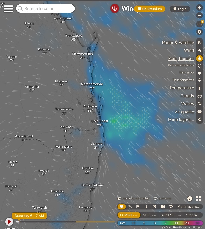 Stormcast with possible storm. As I said prior mainly inland interior.  But as per usual this is Queensland and it can buck the trend. So if anything does develop please listen for any warnings. But from the modelling system there does not appear to be any major storm activity for this area of this thread. Just need to see what the Airport Sounding and maybe two nearby stations to triangulate for any hints of change in the atmosphere compared to that of the forecasted atmosphere and models. Have a great weekend. |
Colin Maitland. |
|
|
|
|
|
Rank: Advanced Member
Groups: Registered, Administrators Joined: 21/08/2019(UTC) Posts: 941 Location: Brisbane Northside Thanks: 1198 times
Was thanked: 1136 time(s) in 674 post(s)
|
Sunday 7 January looks like it is a stop rewind and play the same weather as we had on Saturday. Possible showers but just a degree or 2 hotter than yesterday. Fortunately we don’t have the terrible heat back yet. It will be definitely worthwhile to keep an eye on the charts forTuesday and Wednesday as it is showing to the probability of some storms for this area within the thread. Have a great Sunday. Edited by user Sunday, 7 January 2024 1:24:33 PM(UTC)
| Reason: Missed out the “the” before the word probability . 😳😵💫😜 |
Colin Maitland. |
|
|
|
|
|
Rank: Advanced Member
Groups: Registered, Administrators Joined: 21/08/2019(UTC) Posts: 941 Location: Brisbane Northside Thanks: 1198 times
Was thanked: 1136 time(s) in 674 post(s)
|
Monday 8 January. For SeQLD and NE NSW. More isolated showers to come, with temperatures in the high 20”$ and low 30’s. An Easterly breeze blowing over much of SEQLD while tending to a Northeasterly In the NE NSW area.
I am keeping an eye on the charts as we might see a few storms brewing tomorrow, but at this stage nothing big. The sheer at this stage is a little week but feeding the forecasted temperature, dew points and Hpa into the sounding, there is a negative cap so storms should fire fairly easily. These may be in the form of thundery showers at this stage. So just waiting for an updated run to see what tomorrow and Wednesday has install for this area.
Have a great day and stay safe. |
Colin Maitland. |
|
|
|
|
|
Rank: Advanced Member
Groups: Registered, Administrators Joined: 21/08/2019(UTC) Posts: 941 Location: Brisbane Northside Thanks: 1198 times
Was thanked: 1136 time(s) in 674 post(s)
|
This morning’s sounding from the Brisbane Airport shows a lot of moisture within the highlighted atmosphere. Indicates we may see more showers than first was forecast for the area. Winds are pushing showers onshore and a trough further south is pushing a band of showers over NSW towards the east coast.  Edited by user Monday, 8 January 2024 11:16:14 AM(UTC)
| Reason: Not specified |
Colin Maitland. |
|
|
|
|
|
Rank: Advanced Member
Groups: Registered, Administrators Joined: 21/08/2019(UTC) Posts: 941 Location: Brisbane Northside Thanks: 1198 times
Was thanked: 1136 time(s) in 674 post(s)
|
Well today took a turn that I was not expecting till early tomorrow morning to mid morning on Tuesday. I will post the sounding again and the two big takeaways from the sounding is the lack of shear so any rain is going to move very slowly and the second is the moisture that I highlighted. Some ,massive falls have been recorded and can be seen on the Storm Warning for heavy rain.  Storm warning  Radar  The rainfall since 9:00 am  |
Colin Maitland. |
|
|
|
|
|
Rank: Advanced Member
Groups: Registered, Administrators Joined: 21/08/2019(UTC) Posts: 941 Location: Brisbane Northside Thanks: 1198 times
Was thanked: 1136 time(s) in 674 post(s)
|
Latest Storm warning for Heavy Rainfalls 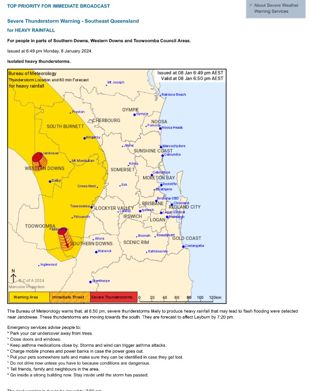 . Rainfall accumulation throughout the Southeast 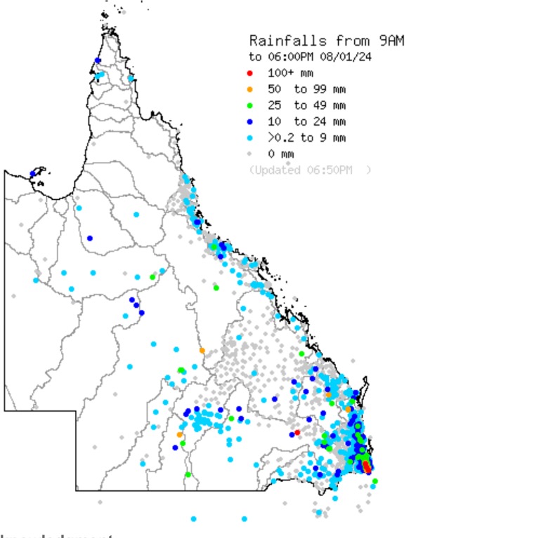 It looks like we are in for the same weather pattern tomorrow. Storms are possible for heavy rain. Maybe a few rumbles in those embedded cells. Just please watch and listen for any warnings that may be issued. |
Colin Maitland. |
|
|
|
|
|
Rank: Advanced Member
Groups: Registered, Administrators Joined: 21/08/2019(UTC) Posts: 941 Location: Brisbane Northside Thanks: 1198 times
Was thanked: 1136 time(s) in 674 post(s)
|
Very hot and humid. Storm warnings have already been issued for parts of the Southeast and the Scenic Rim area. The soundings are much the same in regards to steering winds, that is they are very weak, so storm or showers will move slowly over land. It is important to be vigilant as these could cause flash flooding in that area and also down stream as the water rushes down the creeks, Rivers or causeways.   Radar as at 0835  Rain totals for the last 24 hours to 0900 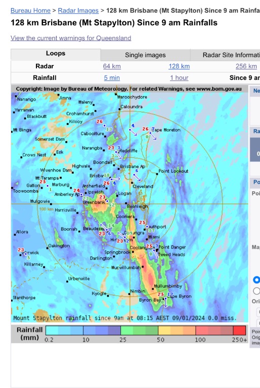 |
Colin Maitland. |
|
|
|
|
|
Rank: Advanced Member
Groups: Registered, Administrators Joined: 21/08/2019(UTC) Posts: 941 Location: Brisbane Northside Thanks: 1198 times
Was thanked: 1136 time(s) in 674 post(s)
|
Please just keep an eye on the radar or look and listen for any possible storm warnings this afternoon. I am keeping things simple and not going into what the models are indicating etc. I had an eye opener yesterday and this morning. So many people are not copping with what has and is happening with the weather since we were hit with all the severe storms, floods and cyclones across Australia. People are hurting so bad. Some right now can’t see a way out. If you are struggling please reach out and talk. On here if you want to join in on the forum and post in this thread please feel free. Even if it is something like it is hot here! It’s raining or if you want to post a little bit more technical please do so. I try and keep everything as simple as possible. I could write some forecast and use words that may go over some peoples heads and get to technical. I read many years ago that weather should be presented in a way that everyone can understand. So please feel free to join in. There are other threads as you would know for other areas right around the world on this forum. Paul has created a fantastic forum here so please join in on the conversation. If you are struggling and have been affected by these storms I am so sorry, but also please seek help and talk. Stay safe. Colin Edited by user Tuesday, 9 January 2024 2:50:12 PM(UTC)
| Reason: Not specified |
Colin Maitland. |
|
|
|
|
|
Rank: Advanced Member
Groups: Registered, Administrators Joined: 21/08/2019(UTC) Posts: 941 Location: Brisbane Northside Thanks: 1198 times
Was thanked: 1136 time(s) in 674 post(s)
|
|
Colin Maitland. |
|
|
|
|
|
Weather Forum
»
Australia Weather
»
SEQ and NE NSW
»
SE QLD and NE NSW - Day to day Weather 2024
Forum Jump
You cannot post new topics in this forum.
You cannot reply to topics in this forum.
You cannot delete your posts in this forum.
You cannot edit your posts in this forum.
You cannot create polls in this forum.
You cannot vote in polls in this forum.
Important Information:
The Weather Forum uses cookies. By continuing to browse this site, you are agreeing to our use of cookies.
More Details
Close
