Weather Forum
»
Australia Weather
»
SEQ and NE NSW
»
SE QLD and NE NSW - Day to day Weather 2024
Rank: Advanced Member
Groups: Registered, Administrators Joined: 21/08/2019(UTC) Posts: 941  Location: Brisbane Northside Thanks: 1198 times
Was thanked: 1136 time(s) in 674 post(s)
|
Latest STW with A very Dangerous Storm labelled 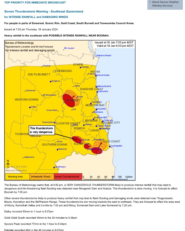 |
Colin Maitland. |
|
|
|
|
|
Rank: Advanced Member
Groups: Registered, Administrators Joined: 21/08/2019(UTC) Posts: 941 Location: Brisbane Northside Thanks: 1198 times
Was thanked: 1136 time(s) in 674 post(s)
|
|
Colin Maitland. |
|
|
|
|
|
Rank: Advanced Member
Groups: Registered, Administrators Joined: 21/08/2019(UTC) Posts: 941 Location: Brisbane Northside Thanks: 1198 times
Was thanked: 1136 time(s) in 674 post(s)
|
What a hot humid night. Actual temperature through out the night was 25.8°C, dew point was 25.8°C and the apparent or feels like temperature was 31.5°C. Heavy rain hit around 01:00 am and we had a total at Lawnton of 21 mm. Yesterday there were pockets of showers and storms albeit very slow moving. I think this was one of a few reasons we didn’t see the day pan out as the models indicated, the steering winds were not strong at all, so the cells that developed stalled. It has been tricky lately trying to get things smack on. The models are underperforming and even BoM are updating forecast at all times of the day. And there are a few reasons for this too. The atmosphere is so primed and dynamic that just the slightest change effects the whole set up. Plus the monsoonal weather up in the North and the Lows are having an impact on our weather. The Coral Sea low is not expected to form into a cyclone until Monday now. That keeps moving around and is keeping models and forecasters guessing the next move. Today for the South East and NE NSW it is much the same as the last couple of days. Showers with possible storms and some could be heavy falls once again if you happen to be under one. Going by the GFS model below and Sounding it is very Coastal and not a lot of rain nor steering/ shear through the 700-500 mb.. So it could be hit and miss, or things could rapidly change. So please just keep an eye to the sky and listen and watch for any warnings if things change. Possible showers 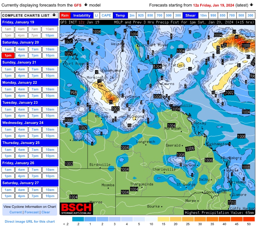 The Cape values plus you can see the red areas of the 2 main lows effecting our weather right now. 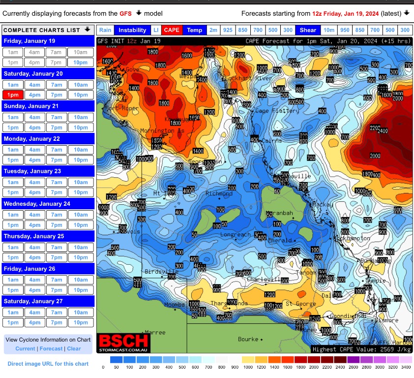 The forecast Sounding with a lack of steering 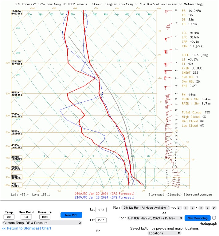 |
Colin Maitland. |
|
|
|
|
|
Rank: Advanced Member
Groups: Registered, Administrators Joined: 21/08/2019(UTC) Posts: 941 Location: Brisbane Northside Thanks: 1198 times
Was thanked: 1136 time(s) in 674 post(s)
|
2 cells, one near Crows Nest and the other near Boonah has been throwing down some heavy falls over the last hour or so. 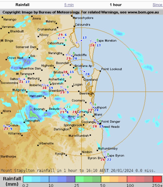 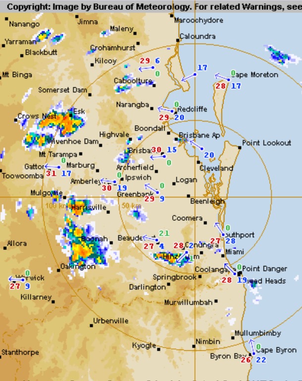 |
Colin Maitland. |
|
|
|
|
|
Rank: Advanced Member
Groups: Registered, Administrators Joined: 21/08/2019(UTC) Posts: 941 Location: Brisbane Northside Thanks: 1198 times
Was thanked: 1136 time(s) in 674 post(s)
|
Just after I post, BoM have updated their STW,. Unfortunately a little late but at least they have taken action. 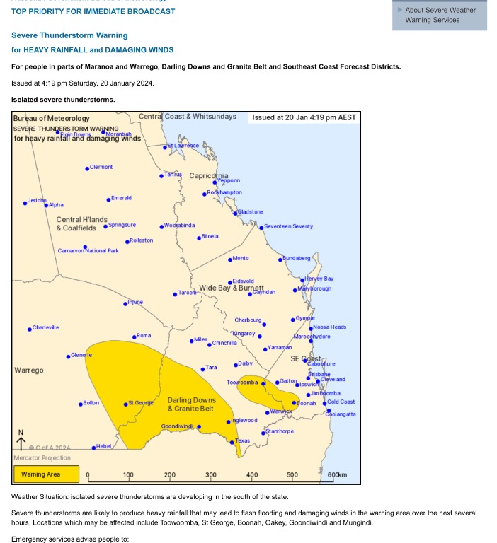 |
Colin Maitland. |
|
|
|
|
|
Rank: Advanced Member
Groups: Registered, Administrators Joined: 21/08/2019(UTC) Posts: 941 Location: Brisbane Northside Thanks: 1198 times
Was thanked: 1136 time(s) in 674 post(s)
|
Latest STW 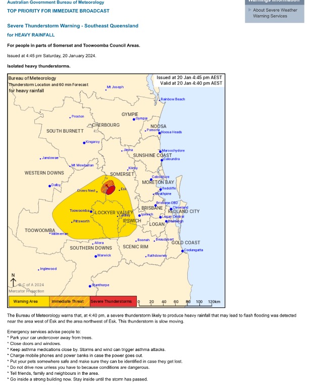 |
Colin Maitland. |
|
|
|
|
|
Rank: Advanced Member
Groups: Registered, Administrators Joined: 21/08/2019(UTC) Posts: 941 Location: Brisbane Northside Thanks: 1198 times
Was thanked: 1136 time(s) in 674 post(s)
|
A very hot and humid day. The chance of any storms seem to be heading North into the Low that is in the Coral Sea. Below is just a simple way of looking at the setups of the weather using just the Lifted Index charts. Sunday 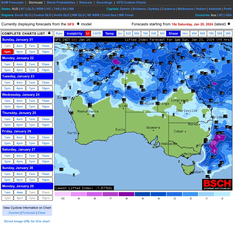 Monday 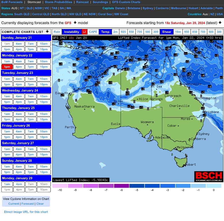 Wednesday 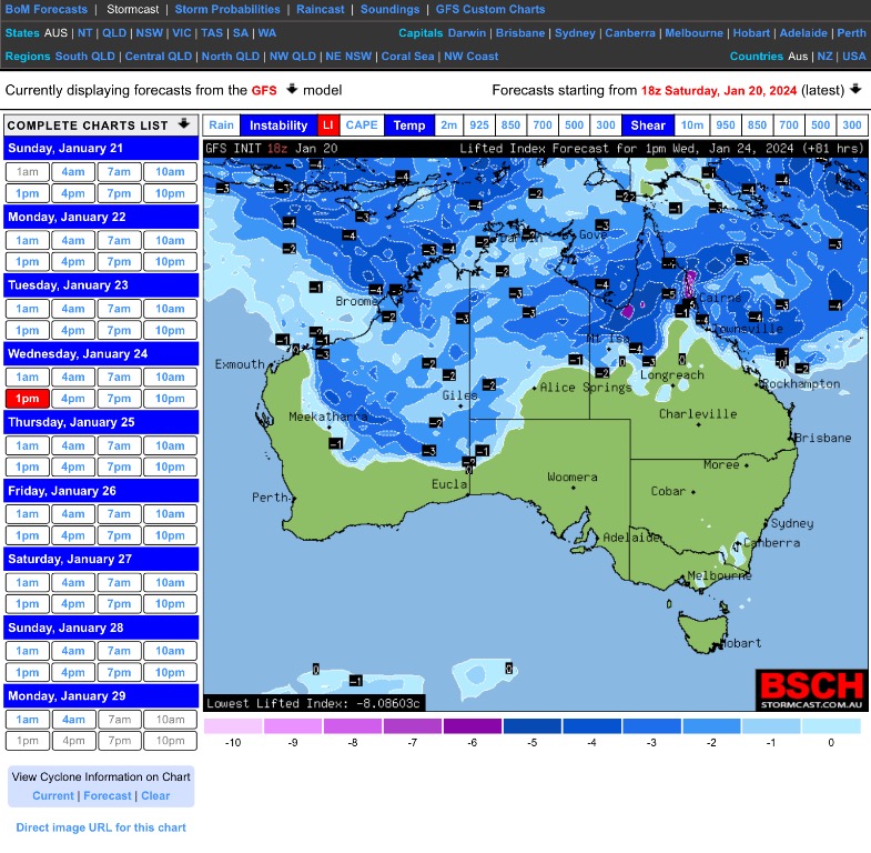 Edited by user Sunday, 21 January 2024 11:03:06 AM(UTC)
| Reason: Fixing grammar and wording. |
Colin Maitland. |
|
|
|
|
|
Rank: Advanced Member
Groups: Registered, Administrators Joined: 21/08/2019(UTC) Posts: 941 Location: Brisbane Northside Thanks: 1198 times
Was thanked: 1136 time(s) in 674 post(s)
|
This is the latest from BoM regarding the Tropical Low 05U/ possible TC Forecast track path valid Sunday 21 January 2024 for Tropical Low 05U / possible TC  Latest Spaghetti Ensemble of the possible track paths it could take  The areas that maybe affected by the Low O5U / possible TC  Technical data available for the system IDQ20065 Australian Bureau of Meteorology Tropical Cyclone Warning Centre TROPICAL CYCLONE INFORMATION BULLETIN Issued at 10:54 am EST on Sunday 21 January 2024 At 10 am AEST Sunday, a Tropical Low with central pressure 998 hPa was located over the Coral sea near latitude 15.0 south longitude 154.4 east, which is about 495 km east northeast of Willis Island and 940 km east northeast of Townsville. The low is slow moving and should gradually intensify over the next 24 hours. Tropical Low 05U is developing in the Coral Sea and is forecast to track towards the Queensland coast. A coastal crossing is likely around the middle of the week, with the most likely zone being between about Cairns and Mackay. A severe coastal impact is possible, particularly if the system crosses near or south of Townsville. The next Information Bulletin will be issued by 5 pm AEST today. Edited by user Sunday, 21 January 2024 12:44:36 PM(UTC)
| Reason: Added Spag Ensemble and found another spelling mistake |
Colin Maitland. |
|
|
|
|
|
Rank: Advanced Member
Groups: Registered, Administrators Joined: 21/08/2019(UTC) Posts: 941 Location: Brisbane Northside Thanks: 1198 times
Was thanked: 1136 time(s) in 674 post(s)
|
Latest offering by BoM on Meteye regardingTropical Low 05U. Unfortunately you can’t go forward to see the possible/predicted path or strength. It is only available for the time presented.  |
Colin Maitland. |
|
|
|
|
|
Rank: Advanced Member
Groups: Registered, Administrators Joined: 21/08/2019(UTC) Posts: 941 Location: Brisbane Northside Thanks: 1198 times
Was thanked: 1136 time(s) in 674 post(s)
|
One little nasty cell with heavy rain just South of the SEQ border. I don’t think BoM have looked at it. But anyway see what happens. 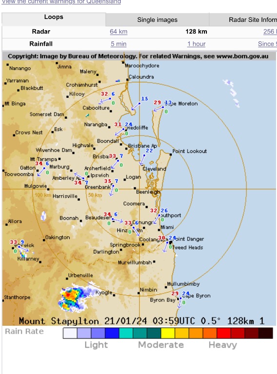 Rain rate 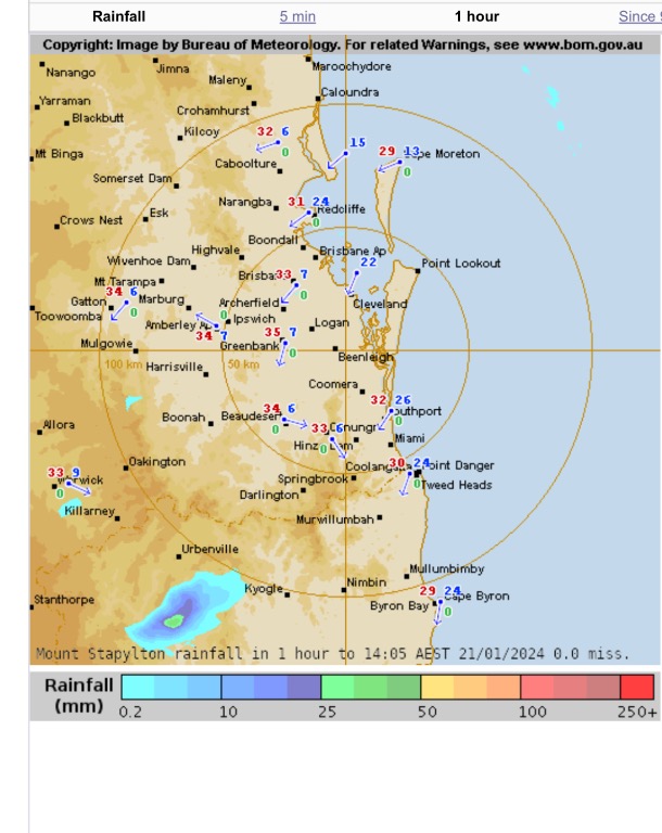 Interested little doppler view.  Edited by user Sunday, 21 January 2024 2:17:40 PM(UTC)
| Reason: Not specified |
Colin Maitland. |
|
|
|
|
|
Rank: Advanced Member
Groups: Registered, Administrators Joined: 21/08/2019(UTC) Posts: 941 Location: Brisbane Northside Thanks: 1198 times
Was thanked: 1136 time(s) in 674 post(s)
|
Just having a look at the 512K Willis Island Radar and the low is still heading in a NNE direction. As per the doppler radar you can see the main system is moving away from the radar, that is North of the radar. This is in line with 10:00am- 10:00pm 21 /01/24 track path.  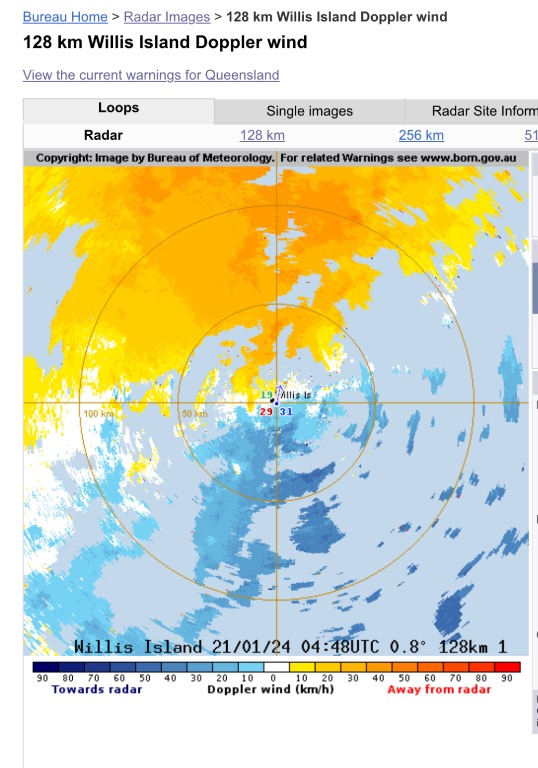 Track path showing todays slight movement to the North. 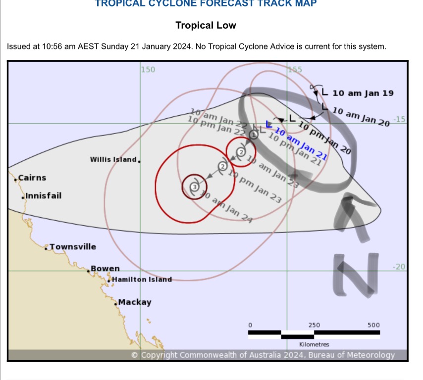 I just find this little things interesting. |
Colin Maitland. |
 2 users thanked Colmait for this useful post.
|
|
|
|
Rank: Advanced Member
Groups: Registered, Administrators Joined: 21/08/2019(UTC) Posts: 941 Location: Brisbane Northside Thanks: 1198 times
Was thanked: 1136 time(s) in 674 post(s)
|
A Hot and Humid day install for much of Queensland. The Dew points are making the atmosphere feel so oppressive. With temperatures in the mid to high 30’s predicted, the high dew points will make the feel like temperature closer to 40°C plus. There is a very small/slim chance of a tiny band of storms just around the Coastal areas on the border up to Brisbane. But the forecast sounding has a massive dry slot in the lower levels then increase to drier air above. So we could see some towers go up, maybe a dry cell or virga with a rumble or two, but it is a slim chance. As for the Low 05U not a lot has changed at this stage. It is very slow moving but should start to move a little to the West. The models are sort of coming into a alignment in small variations but it is still a long way out in the life of a Tropical Low/Cyclone. The latest Meteye has the Tropical storm moving inland still and moving a little further south with a recurve towards the coast. But once again we are a long way out. The best way to describe this scenario comes down to Lorenzo’s chaos theory that he discovered while running a weather model in the 1950’s. It became better known as the butterfly effect. The small changes added together can make a bigger change to a storm system such as 05U. So at this stage stay cool and here is the latest Meteye run from BoM.  |
Colin Maitland. |
|
|
|
|
|
Rank: Advanced Member
Groups: Registered, Administrators Joined: 21/08/2019(UTC) Posts: 941 Location: Brisbane Northside Thanks: 1198 times
Was thanked: 1136 time(s) in 674 post(s)
|
Just saw an update and there has been a slight movement to the North with the possible crossing of the Coast. This is where the models will jump around so much. Those tiny butterfly effects. But it is just worth keeping an archive of the movement in the models for future references. This all could change in the next few hours. The other scenario is it could burn it self out by using a lot of the warm water it is sitting over. So many variables to consider. Time will tell us what is happening. Posted this Meteye stormcast this morning.  This is the latest and you can see the crossing is closer to Townsville at this point in time. Be interesting to see where it does eventually cross and if it does cross is another scenario. So many variables as I said before. The main thing is to prepare for the worse and hope for the best. That is all we can do. Keep an eye and ear to all the advice/warnings from BoM and reliable media sources. Some FB pages have a doomsday scenario and we know better than BoM attitude, so please choose wisely and stay calm and have a plan of action.  Edited by user Monday, 22 January 2024 11:04:16 AM(UTC)
| Reason: Not specified |
Colin Maitland. |
|
|
|
|
|
Rank: Advanced Member
Groups: Registered, Administrators Joined: 21/08/2019(UTC) Posts: 941 Location: Brisbane Northside Thanks: 1198 times
Was thanked: 1136 time(s) in 674 post(s)
|
STW for NE NSW  Radar 1 NE NSW storm cell 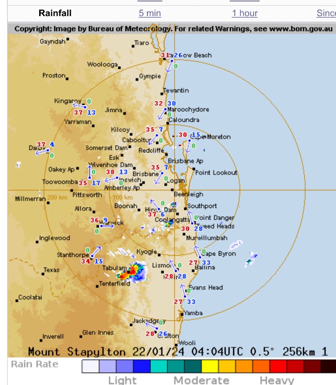 Radar 2. Some cells starting to develop around the North of the Gold Coast. 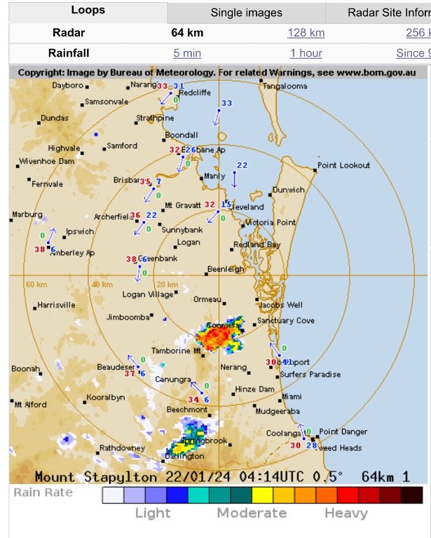 |
Colin Maitland. |
|
|
|
|
|
Rank: Advanced Member
Groups: Registered, Administrators Joined: 21/08/2019(UTC) Posts: 941 Location: Brisbane Northside Thanks: 1198 times
Was thanked: 1136 time(s) in 674 post(s)
|
A very hot and humid day for the area of this thread. But hopefully we will feel the effects of the Southeasterly change that is currently moving through.  |
Colin Maitland. |
|
|
|
|
|
Rank: Advanced Member
Groups: Registered, Administrators Joined: 21/08/2019(UTC) Posts: 941 Location: Brisbane Northside Thanks: 1198 times
Was thanked: 1136 time(s) in 674 post(s)
|
The latest Advisory update 3 for Possible Cyclone. The only reason I say possible is due to the lack of structure at this very point in time. Still quite messy on the Satellite Imagery. But this could change over the next 12-24 hours. TROPICAL CYCLONE ADVICE NUMBER 3 Issued at 4:44 pm EST on Monday 22 January 2024 Headline: Tropical cyclone impact likely on the Queensland coast from Wednesday. Areas Affected: Warning Zone None. Watch Zone Cairns to St Lawrence (not including Cairns), including Townsville, Mackay and the Whitsunday Islands . Cancelled Zone None. Details of Tropical Low at 4:00 pm AEST [3:30 pm ACST]: Intensity: Tropical Low, sustained winds near the centre of 55 kilometres per hour with wind gusts to 85 kilometres per hour. Location: within 55 kilometres of 15.6 degrees South 153.9 degrees East, estimated to be 860 kilometres east northeast of Townsville and 425 kilometres east of Willis Island. Movement: slow moving. A tropical low (05U) is slow moving in the central Coral Sea and is likely to become a tropical cyclone during late Tuesday. This system is forecast to track southwest over the next few days towards the Queensland coast as it intensifies. The system is forecast to cross the coast, most likely on Thursday between Innisfail and Airlie Beach. From Friday, the system is forecast to move inland and then further south. Track path  And the latest Meteye with its metadata forecasting. 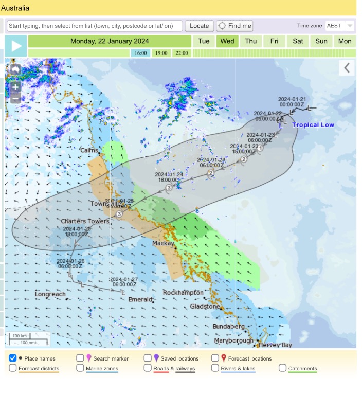 |
Colin Maitland. |
|
|
|
|
|
Rank: Advanced Member
Groups: Registered, Administrators Joined: 21/08/2019(UTC) Posts: 941 Location: Brisbane Northside Thanks: 1198 times
Was thanked: 1136 time(s) in 674 post(s)
|
That slim chance of a storm did come together. GFS had a very small area and isolated chance of a storm East of the Ranges. 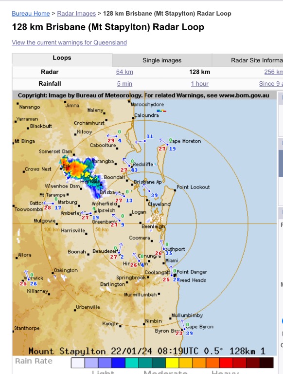  |
Colin Maitland. |
|
|
|
|
|
Rank: Advanced Member
Groups: Registered, Administrators Joined: 21/08/2019(UTC) Posts: 941 Location: Brisbane Northside Thanks: 1198 times
Was thanked: 1136 time(s) in 674 post(s)
|
A little bit of a reprieve from the hot weather. If you can get into the breeze is quite comfortable, but once you are out of it, hot and humid but nowhere near the last few days. Most of the action right now is with the Tropical low 05U and a thread has been started for it at https://www.weatherforum...cal-Low-05U-January-2024 |
Colin Maitland. |
|
|
|
|
|
Rank: Advanced Member
Groups: Registered, Administrators Joined: 21/08/2019(UTC) Posts: 941 Location: Brisbane Northside Thanks: 1198 times
Was thanked: 1136 time(s) in 674 post(s)
|
More warm/ hot cloudy days. The expected rain has stalled due to the Tropical Lows for slow movement. So Saturday, Sunday and Monday are shaping up to be the wet days at this point in time. Not a lot of rain is expected. But just have to see the impact, if any, this low has on us. Just using the LIi charts to show the low is dragging any wet weather or storms to the North. 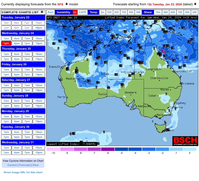 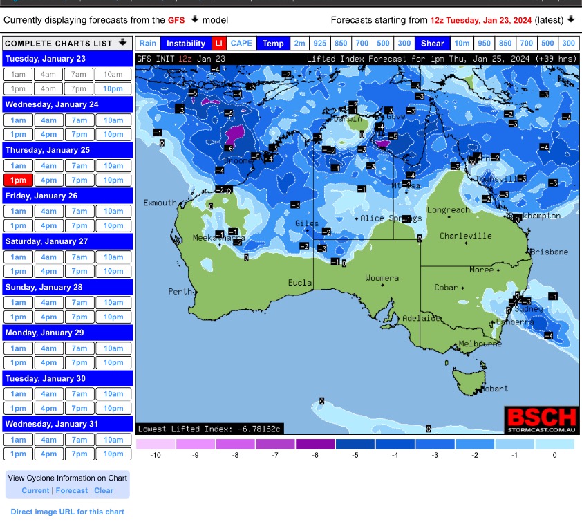 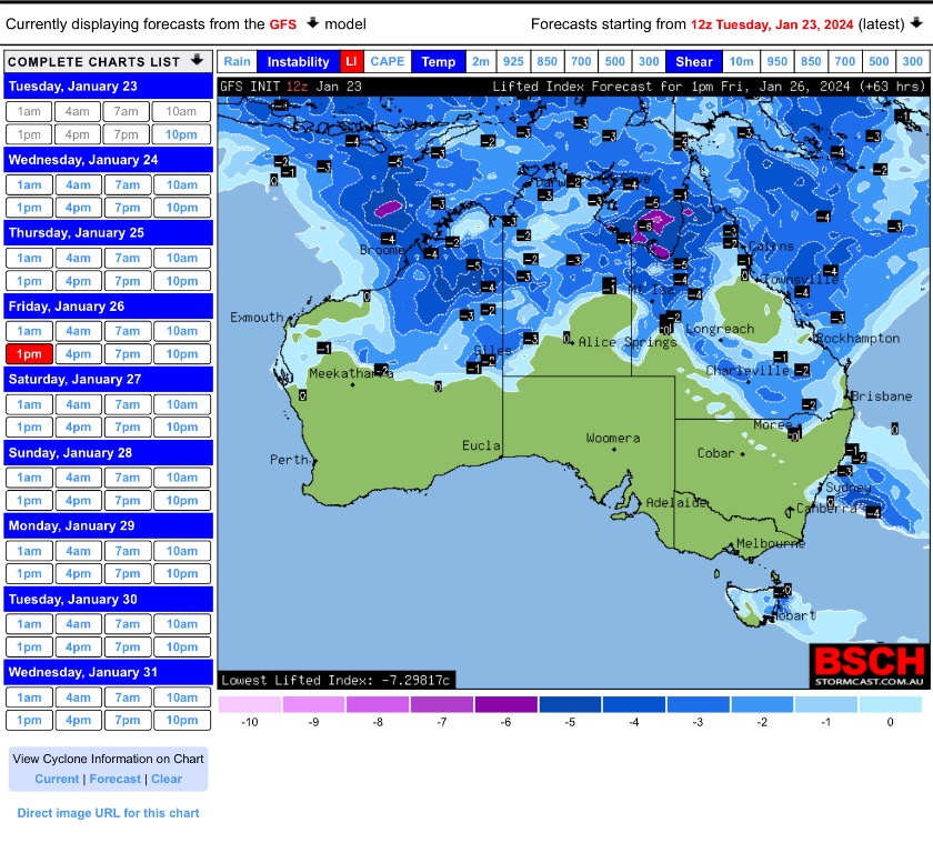 Edited by user Wednesday, 24 January 2024 6:22:48 AM(UTC)
| Reason: Not specified |
Colin Maitland. |
|
|
|
|
|
Rank: Advanced Member
Groups: Registered, Administrators Joined: 21/08/2019(UTC) Posts: 941 Location: Brisbane Northside Thanks: 1198 times
Was thanked: 1136 time(s) in 674 post(s)
|
This afternoon the Tropical Low up North has now officially been named Tropical Cyclone Kirrily. TOP PRIORITY FOR IMMEDIATE BROADCAST TROPICAL CYCLONE ADVICE NUMBER 15 Issued at 4:49 pm EST on Wednesday 24 January 2024 Headline: Impacts from Tropical Cyclone Kirrily likely to begin for coastal and island communities tonight and Thursday morning. Areas Affected: Warning Zone Cardwell to Sarina, including Townsville, Mackay, Bowen, the Whitsunday Islands, and extending inland to Charters Towers. Watch Zone Innisfail to Cardwell. Cancelled Zone None. Details of Tropical Cyclone Kirrily at 4:00 pm AEST: Intensity: Category 1, sustained winds near the centre of 75 kilometres per hour with wind gusts to 100 kilometres per hour. Location: within 55 kilometres of 17.4 degrees South 152.4 degrees East, estimated to be 630 kilometres east northeast of Townsville and 530 kilometres northeast of Mackay. Movement: slow moving. Tropical Cyclone Kirrily has developed in the central Coral Sea, and is expected to continue strengthening as it tracks west southwest towards the Queensland coast. The system is likely to cross the Queensland coast Thursday night between Cardwell and Bowen as a Category 2 system. In the longer term, the system is likely to track further inland as a tropical low, bringing heavy to intense rain to parts of the northern interior and western Queensland. 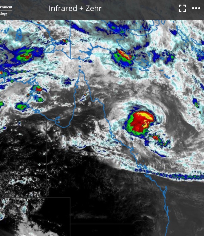 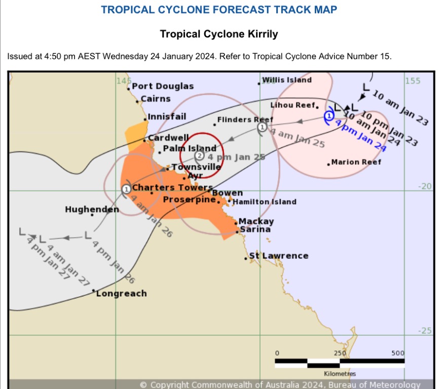 |
Colin Maitland. |
|
|
|
|
|
Weather Forum
»
Australia Weather
»
SEQ and NE NSW
»
SE QLD and NE NSW - Day to day Weather 2024
Forum Jump
You cannot post new topics in this forum.
You cannot reply to topics in this forum.
You cannot delete your posts in this forum.
You cannot edit your posts in this forum.
You cannot create polls in this forum.
You cannot vote in polls in this forum.
Important Information:
The Weather Forum uses cookies. By continuing to browse this site, you are agreeing to our use of cookies.
More Details
Close
