Weather Forum
»
Australia Weather
»
SEQ and NE NSW
»
SE QLD and NE NSW - Day to day Weather 2024
Rank: Advanced Member
Groups: Registered, Administrators Joined: 21/08/2019(UTC) Posts: 941  Location: Brisbane Northside Thanks: 1198 times
Was thanked: 1136 time(s) in 674 post(s)
|
A very hot and humid night last night.Temperatures for Brisbane never fell below 27°C all night and with the high dew points the feel like temperature hovered around the 33-34°C mark throughout the night. Unfortunately Saturday night is much of a repeat. There is a slim chance of a storm but more to the South of Brisbane and over the border. We could see an early morning rumble from around 01:00 am -04:00 am Sunday and then another storm towards the evening possibly severe. A lot of energy in the atmosphere but we just have to see how it will shape up throughout Sunday. Below is the temperature observation for Brisbane. The same was felt through out much of the South East Coastal areas.  Storm potentials for Saturday/ Sunday 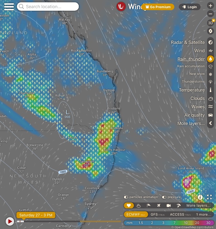   Edited by user Saturday, 27 January 2024 6:39:13 AM(UTC)
| Reason: Not specified |
Colin Maitland. |
|
|
|
|
|
Rank: Advanced Member
Groups: Registered, Administrators Joined: 21/08/2019(UTC) Posts: 941 Location: Brisbane Northside Thanks: 1198 times
Was thanked: 1136 time(s) in 674 post(s)
|
At 10:00 pm Saturday night the temperature is still sitting on 29°C with the feel like temperature at 35.2°C. A very oppressive 24 hours. Showers and storms are approaching and we still may get an early rumble in the showers/ rain. There is also an upper trough that is stalling due to the ex tropical Cyclone and rain totals of 150mm plus could be on the cards which may lead to flash floods , so please keep an eye and ear out for any warnings that may be issued . The charts showing Monday and Tuesday with the bigger falls but these could be seen as early as Sunday. Current radar and Brisbane observations.   |
Colin Maitland. |
|
|
|
|
|
Rank: Advanced Member
Groups: Registered, Administrators Joined: 21/08/2019(UTC) Posts: 941 Location: Brisbane Northside Thanks: 1198 times
Was thanked: 1136 time(s) in 674 post(s)
|
An agonising and oppressive night. The feel like temperature sat around 35.2 ° C most of the night until the wind started to change direction and there was a slight reprieve, if you could call it that. The temperature dropped a little bit to 31.2° at approximately 3:30 am then down to 290°C around 4:30 am. This is the first time in 30 years we have not had air conditioning. So we felt the full blast of mother natures heatwave.  Storms have dropped some big totals of rain with some areas receiving over 100mm . Below is the Brisbane metropolitan rainfall charts.  More storms are forecast for today and tomorrow with some heavy rain for Tuesday. The trough is very slow moving, even last night the rain we received didn’t arrive until about 3:30 where as the modelling suggested about 1:00 am. ( that is for our direct area in the SEQLD corner.). These storms and rain can be quite dangerous for the rainrate per hour totals so please be careful and listen or look for any warnings that may be given by BoM and then through your Councils Early Warning text.  Edited by user Sunday, 28 January 2024 9:20:31 AM(UTC)
| Reason: I lost data while posting and just reread and grammar mistakes. Very tired . |
Colin Maitland. |
 1 user thanked Colmait for this useful post.
|
|
|
|
Rank: Advanced Member
Groups: Registered, Administrators Joined: 21/08/2019(UTC) Posts: 941 Location: Brisbane Northside Thanks: 1198 times
Was thanked: 1136 time(s) in 674 post(s)
|
A possible severe storm situation arising that could be quite dangerous. Storm cells as can be seen on the radar are very slow moving. Hourly rain rates are starting to build so flash flooding is a very serious threat.   STW  |
Colin Maitland. |
|
|
|
|
|
Rank: Advanced Member
Groups: Registered, Administrators Joined: 21/08/2019(UTC) Posts: 941 Location: Brisbane Northside Thanks: 1198 times
Was thanked: 1136 time(s) in 674 post(s)
|
Another hot and humid night last night and this mornings. Although it was a little cooler the feel like temperatures sat around the 31° - 32° C for most of the night.  As for SEQLD and NE NSW the remnants of the tropical low to the North West with a slow moving ridge over the Southeast of QLD will continue to produce showers/ rain and possible storms. Also a low is expected to develop off the South East Coast and enhance the rainfall. The low is expected to move away from the Coast from Thursday onwards. Below is the ECMFW, GFS and the good old 4 day chart. That chart is about all we had in the 70’s and 80’s to work out our weather for a surf, dive or sail. Good old days though. Now we can get our hands on all sorts of models that tell us all sorts of things depending on the model and how it underperforms or over performs to catastrophic levels or it may even get it right. But EC and GFS are at this point in line with a low developing and it moving away from the coast with it just enhancing the rainfall. So with heavy falls from rain and possible storms that may hit over the next few days, please keep and eye and ear open for any warnings.   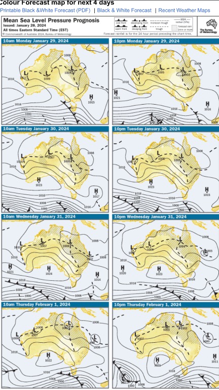 |
Colin Maitland. |
1 user thanked Colmait for this useful post.
|
|
|
|
Rank: Advanced Member
Groups: Registered, Administrators Joined: 21/08/2019(UTC) Posts: 941 Location: Brisbane Northside Thanks: 1198 times
Was thanked: 1136 time(s) in 674 post(s)
|
|
Colin Maitland. |
|
|
|
|
|
Rank: Advanced Member
Groups: Registered, Administrators Joined: 21/08/2019(UTC) Posts: 941 Location: Brisbane Northside Thanks: 1198 times
Was thanked: 1136 time(s) in 674 post(s)
|
Some huge rainfall totals as at 3:30 am Cedar Creek 239 mm Samford 318mm Drapers Crossing AL 274mm Eatons Hill 181 mm Lawnton 146mm Warner 185 mm A very dangerous storm for these areas was still current when writing this.  The radar at 3:20 am  And rainfall totals    The heat has been unbearable once again. Only running on about 8 hours since Friday night. Absolutely exhausted. Stay safe and listen for any warnings or flood information especially around those Northern Suburbs and the flow on from the creeks. |
Colin Maitland. |
|
|
|
|
|
Rank: Advanced Member
Groups: Registered, Administrators Joined: 21/08/2019(UTC) Posts: 941 Location: Brisbane Northside Thanks: 1198 times
Was thanked: 1136 time(s) in 674 post(s)
|
Another STW for a dangerous cell moving over Burpengary, Narangba and towards Lawnton . 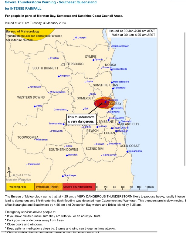 |
Colin Maitland. |
|
|
|
|
|
Rank: Advanced Member
Groups: Registered, Administrators Joined: 21/08/2019(UTC) Posts: 941 Location: Brisbane Northside Thanks: 1198 times
Was thanked: 1136 time(s) in 674 post(s)
|
 Ex Kirrily,(blue circle), is expected to hang around the Northwest for a few more days. We had a massive deep trough over Southern Queensland and with all that extreme heat there was an excessive amount of moisture. In fact the precipitable water in yesterday afternoons sounding broke a record with 73.5mm. BoM put up another balloon last night and it broke the record again with 74.2 mm. Just an absolutely saturated atmosphere. Ex Kirrily helped to fuel and move the trough Northeast and a low, in yellow, is now developing off the Coast. Exactly what the low will do is a bit of an unknown as the models have a few scenarios, so it is a wait and see if it does veer back towards the Coast or moves East.??? It was unfortunately a pretty wild afternoon/night for some areas. Some places copping over 300mm in 3 hours. It has caused a fair bit of flooding. Houses a suburb over from here, had a meter of water through them. Many other places over the Southeast have also flooded, houses and businesses. Road closures everywhere. Farms flattened once again in the Lockyear Valley so expect to see higher food prices again. From what I saw with a couple of Bridges, there must have been a 6 feet wall of water hit at around 2:30am. Would have taken some force to damage the 2 bridges like it did. That is the thick guard rails and hand rails. On the TV those in Bray Park said they were awoken by water in the house, the last time it flooded they said it was slow, but this time they had no warning. It picked up an empty Ford Ute and it floated 250 meters down the street. Dew points are not expected to be as high as they have been throughout the heatwave, so hopefully those horrid temperatures are gone for a little bit. I have a feeling we may see them again. Extreme weather events happening right around the world and we are not immune to them here unfortunately. |
Colin Maitland. |
1 user thanked Colmait for this useful post.
|
|
|
|
Rank: Advanced Member
Groups: Registered, Administrators Joined: 21/08/2019(UTC) Posts: 941 Location: Brisbane Northside Thanks: 1198 times
Was thanked: 1136 time(s) in 674 post(s)
|
 The PW Greater than 44.45 mm represents a water loaded sounding. Less than 19.5mm represents a fairly dry sounding. |
Colin Maitland. |
|
|
|
|
|
Rank: Advanced Member
Groups: Registered, Administrators Joined: 21/08/2019(UTC) Posts: 941 Location: Brisbane Northside Thanks: 1198 times
Was thanked: 1136 time(s) in 674 post(s)
|
The night time temperatures have been way cooler and not as humid over the last 2 nights. Very nice and enjoying it. The weather long range outlook is still a bit of a mixed bag with consensus of the models. They all have different outcomes with the Low of the South East Coast and Ex Kirrily. The accuracy for models this far out is pretty low. When it comes within the 24 hour period, they say the accuracy of the models is about 90% but unfortunately for me, I don’t really subscribe to that point of view. My reason is: how many times do we reach the forecast day and at 05:10 the forecast is out. Anywhere from 07:00- 11:00 BoM have updated the forecast. The weather is just so unpredictable and the slightest changes can have a big impact on the weather. To give credit due, this is not all the time but mainly through a major weather event which is hard to pin point. So from all the models the take away is, ex Kirrily is expected to move to the Gulf then turn sharply and head South. So the Southern Interior of Queensland will be impacted to some degree, the atmosphere to the North is loaded with moisture so there could be a fair bit of rain. ?? Just have to see as we draw closer. Once it moves into the South East , that is where it goes in all directions. So once again just have to wait and see. The Low of the East Coast also has many outcomes, So a wait and see. But while waiting it is a good time to prepare just in case. There is 2 possible Lows that could impact the South East and NE NSW. But the accuracy is just a little over the place from Catastrophic to totally misses us. The best model I could present is the old 4 day as below.  As for today, there is a slight chance for some Coastal showers. Below is the SkewT ( which shows a little moisture but the chance for a storm are about nil) And also the Li Chart and as you can see all the action is around Bunderberg and to the North.   Chance of showers/rain 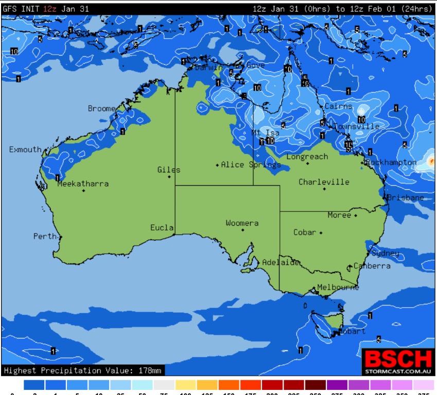 Edited by user Thursday, 1 February 2024 7:09:52 AM(UTC)
| Reason: Not specified |
Colin Maitland. |
|
|
|
|
|
Rank: Advanced Member
Groups: Registered, Administrators Joined: 21/08/2019(UTC) Posts: 941 Location: Brisbane Northside Thanks: 1198 times
Was thanked: 1136 time(s) in 674 post(s)
|
Pleasant morning this morning again. But unfortunately it looks like they will start heating up a little with overnight temperatures expected to rise again. Not as bad as the heatwave at this point. As for Southeast QLD and NSW the chances of showers/rain and storms are just about nil. 99.99% positive it will be a dry day. Below is the Li chart, I use it to mainly show where the action is. And once again it is all in the North under the influence of Ex Kirrily and the heatwave that has a saturated atmosphere that can produce heavy rain and storms. So here is the 1. SkewT: very stable as regard thunderstorms and quite dry 2. Is the Li’s chart. 3. Raincast.    As for ex Kirrily, the models are all over the place once again, with one model throwing another, fourth Cyclone into the mix, this one develops in the Gulf. So I have just posted the 4 day access and Auswave 4 day chart again. I don’t think it fully knows either. Models have Ex Kirrily hitting Melbourne , hitting Sydney and some existing SEQLD???? The Coral sea Low is all over the place with Catastrophic to continuing an Eastward movement. So the best thing is to wait and keep watching and not get caught up in the hype.  Edited by user Friday, 2 February 2024 6:34:59 AM(UTC)
| Reason: Not specified |
Colin Maitland. |
1 user thanked Colmait for this useful post.
|
|
|
|
Rank: Advanced Member
Groups: Registered, Administrators Joined: 21/08/2019(UTC) Posts: 941 Location: Brisbane Northside Thanks: 1198 times
Was thanked: 1136 time(s) in 674 post(s)
|
Temperatures are starting to feel a little warmer than usual thanks to to a slight rise in due points. The feel like or apparent overnight temperatures sat around 29-30°C so it was getting a little uncomfortable once again as can be seen by the Brisbane Observations below.  There is a high pressure ridge sitting over the Southern part of Queensland and it is keeping our weather a quite stable. Areas around the Gold Coast and just over the NE NSW borders may see a shower today but as for the rest of South East Queensland and Ne NSW it is going to be a warm day and no storm activity unless there is a massive atmospheric change. Below is the sounding and storms just won’t fire off with this type of setup.  Raincast.  |
Colin Maitland. |
|
|
|
|
|
Rank: Advanced Member
Groups: Registered, Administrators Joined: 21/08/2019(UTC) Posts: 941 Location: Brisbane Northside Thanks: 1198 times
Was thanked: 1136 time(s) in 674 post(s)
|
A warm cloudy day for most of the South East. There maybe a very slight chance of a light shower within the Southeast. At this stage it does not appear to be any storms as we have quite a stable atmosphere in the South East. Most of todays action is the remnants of Ex Kirrily sliding to the West of us and into NSW later today. Raincast below  Satellite imagery of ex Kirrily.  And forecast sounding this morning. Just need to compare this with the 11:00 Brisbane Soundings when they arrive. But a stable atmosphere with a little bit of moisture, so you would not expect storms at this stage. There is only a weak trough sitting over the Southeast of Queensland that will continue to weaken over the next few days.  |
Colin Maitland. |
|
|
|
|
|
Rank: Advanced Member
Groups: Registered, Administrators Joined: 21/08/2019(UTC) Posts: 941 Location: Brisbane Northside Thanks: 1198 times
Was thanked: 1136 time(s) in 674 post(s)
|
Just running through the models and we are sort of stuck in this holding pattern of above 30°C days warm nights and a possible shower or two if you happen to be under one. There will be a strong ridge over Southwest Queensland from Wednesday that will just sit there for the next 5 days. There is not much rainfall predicted from these showers either.
As for the low in the Coral Sea. It may strengthen and move a little closer to the Coast. But nothing is a certainty once again. So it is a keep an eye on it and see what happens at this point.
|
Colin Maitland. |
|
|
|
|
|
Rank: Advanced Member
Groups: Registered, Administrators Joined: 21/08/2019(UTC) Posts: 941 Location: Brisbane Northside Thanks: 1198 times
Was thanked: 1136 time(s) in 674 post(s)
|
Another warm and humid day install for the South East of Queenslannd and NENSW. There is the slight chance of isolated showers on the Coastal areas. The Ridge has moved over the Eastern part of Queensland and now will strengthen itself and hang around for quite a few days. The result is a repeat pattern of this weather. Chances of storms, unless something drastic happens is extremely low to nil. Just have to see if the low in the Coral Sea can bring any change with it. It is not expected to cross the Coast at this stage with the modelling. Below is the sounding which just is not a good look if you are after a refreshing storm and a cool change. And Image 2 is the possibility of showers today.   Edited by user Wednesday, 7 February 2024 5:55:07 AM(UTC)
| Reason: Not specified |
Colin Maitland. |
|
|
|
|
|
Rank: Advanced Member
Groups: Registered, Administrators Joined: 21/08/2019(UTC) Posts: 941 Location: Brisbane Northside Thanks: 1198 times
Was thanked: 1136 time(s) in 674 post(s)
|
Yesterday saw quite a few showers and heavier than predicted to the North of Brisbane around the Caboolture area. This morning we had a couple of early morning showers around 3:30- 4:30 am. It managed to drop the temperature a little which was nice. Today should see more shower activity along with Southerly turning to Southeasterly winds during the day. Still a warm day but not as unpleasant as it has been. A nice change from those unpleasant extremely hot and humid days. Below is the raincast with the possible showers and Windy highlighting the wind direction and strength. Southeasterly winds are much more pleasant than the Northeasterlies and Northwesterlies we have had to endure this summer. We should see showers persisting over the next few days. 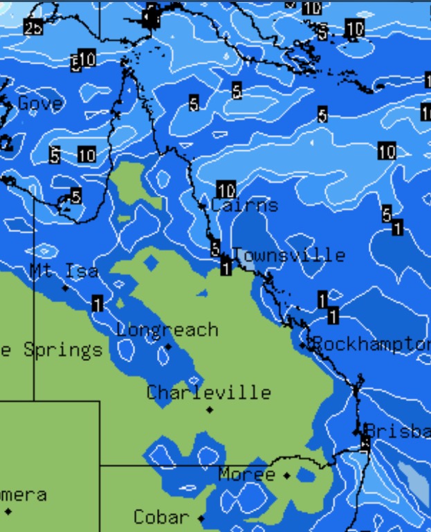 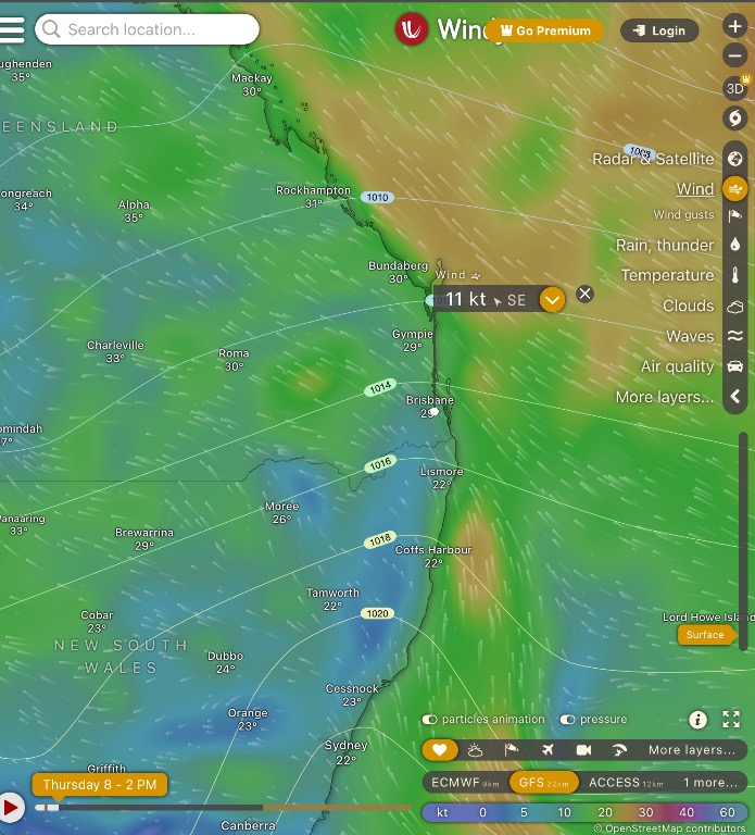 Edited by user Thursday, 8 February 2024 6:15:14 AM(UTC)
| Reason: Not specified |
Colin Maitland. |
|
|
|
|
|
Rank: Advanced Member
Groups: Registered, Administrators Joined: 21/08/2019(UTC) Posts: 941 Location: Brisbane Northside Thanks: 1198 times
Was thanked: 1136 time(s) in 674 post(s)
|
The area of this thread is stuck in a holding pattern of showers and warm days. Although on Saturday there were quite a few showers around and it dropped both the day time and overnight temperature down a little. The ridge over Eastern Queensland is pretty firmly holding its position but is expected to slowly move East over the next week. Today is yet another repeat of showers with temps. in the low 30°C and overnights sitting around 23°C There is a very slim and I do mean the slimiest of chances of a storm on Thursday. I wouldn’t count on it but that is about the most exciting weather event that I can bring to the table. The deep Ridge over Western Queensland is bring showers and storms due to its instability weather wise, so if that moves towards the east as it forecast to do, it could bring about a slight change. Just have to keep an eye out for that. Below is the very slim stormcast from GFS  And below is today’s 24 hour shower total and possible locations.  |
Colin Maitland. |
|
|
|
|
|
Rank: Advanced Member
Groups: Registered, Administrators Joined: 21/08/2019(UTC) Posts: 941 Location: Brisbane Northside Thanks: 1198 times
Was thanked: 1136 time(s) in 674 post(s)
|
Still stuck in this holding pattern although today will be a little more pleasant and should stay below the 30° mark, only just but it is a nice change. Technically Summer is drawing down towards an end and March will see the start of Autumn although we usually don’t see a great difference in the weather. But it has been a hot, humid, wet and dangerous summer this one. Over the next couple of months we will still see temperatures in the 30°C mark. Today should once again see some showers and the only action at this stage, as I posted yesterday, appears to be on Thursday where we could see a thunderstorm. We had a very heavy shower last night over our area around 9:20 pm. This morning was a little more brisk than usual which was nice as well. Below is the raincast with possible showers.  |
Colin Maitland. |
|
|
|
|
|
Rank: Advanced Member
Groups: Registered, Administrators Joined: 21/08/2019(UTC) Posts: 941 Location: Brisbane Northside Thanks: 1198 times
Was thanked: 1136 time(s) in 674 post(s)
|
Been some good chunky showers with a quick sharp heavy downpours around the area. Mt Stapylton radar seems to be down once again. Not much of a surprise to be honest. I have been using Marburg, which since the upgrade has been really good except it doesn’t show rainfalls over 5 minutes, I Hour, 24 hours and the since 9:00 am . Fortunately the Airport radar has been used a fair bit as well but it to lacks the rainfall totals.  |
Colin Maitland. |
|
|
|
|
|
Weather Forum
»
Australia Weather
»
SEQ and NE NSW
»
SE QLD and NE NSW - Day to day Weather 2024
Forum Jump
You cannot post new topics in this forum.
You cannot reply to topics in this forum.
You cannot delete your posts in this forum.
You cannot edit your posts in this forum.
You cannot create polls in this forum.
You cannot vote in polls in this forum.
Important Information:
The Weather Forum uses cookies. By continuing to browse this site, you are agreeing to our use of cookies.
More Details
Close
