Weather Forum
»
Australia Weather
»
SEQ and NE NSW
»
SE QLD and NE NSW - Day to day Weather 2024
Rank: Advanced Member
Groups: Registered, Administrators Joined: 21/08/2019(UTC) Posts: 942  Location: Brisbane Northside Thanks: 1198 times
Was thanked: 1136 time(s) in 674 post(s)
|
A scattered shower or two this morning around the thread area then it should ease back today and Wednesday. Just watching the models, I did say there may be a slim chance of a thunderstorm on Thursday, but this morning that seems to have shifted a day forward to Wednesday. I just have to have a look at the updated model run and see what is happening. I would not expect anything severe “if” something did manage to fire off. All the action today is in the top of the Northern Territory and Queensland with the monsoon and a possible low forming into a cyclone in the Gulf. But below is the raincast for today. Only a shower or two and isolated mainly to the North of Brisbane.  |
Colin Maitland. |
|
|
|
|
|
Rank: Advanced Member
Groups: Registered, Administrators Joined: 21/08/2019(UTC) Posts: 942 Location: Brisbane Northside Thanks: 1198 times
Was thanked: 1136 time(s) in 674 post(s)
|
Still stuck in the same weather pattern. High 20°- 31°C about the East and maybe a little hotter inland towards Ipswich and surrounds. Today may see less shower activity than previous days but there is a very slim chance, and I do mean slim chance of maybe a thunderstorm or thundery showers this afternoon.The winds this afternoon should swing around to the North East and feed into any possible cells or showers that may manage to form. Below is Windy’s GFS take on the probability. 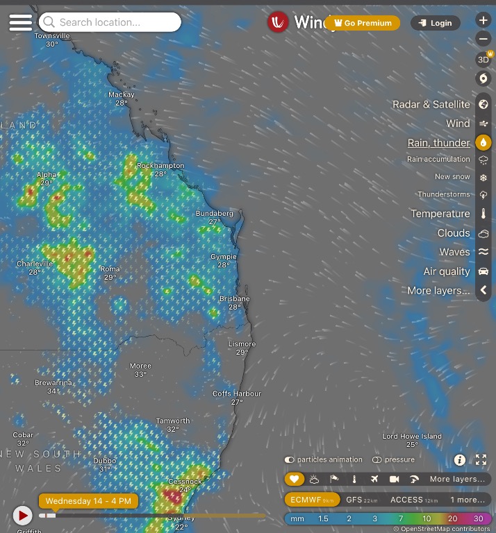 And the forecast sounding as can be seen below. There is not a lot of instability to be seen and it has a small cap of about 1°C to overcome .. Not an ideal setup for a storm but maybe a rumble or two embedded in some scattered showers. Just have to wait and see the actual sounding when it is released.  |
Colin Maitland. |
|
|
|
|
|
Rank: Advanced Member
Groups: Registered, Administrators Joined: 21/08/2019(UTC) Posts: 942 Location: Brisbane Northside Thanks: 1198 times
Was thanked: 1136 time(s) in 674 post(s)
|
There has been so good showers to the North of Gympie this morning and early afternoon. 1 hour rain totals in some area have been around the 25mm mark. Still a chance of a storm about as the afternoon wears on. Below is the Gympie Radar with the 1 hour totals as at 13:10 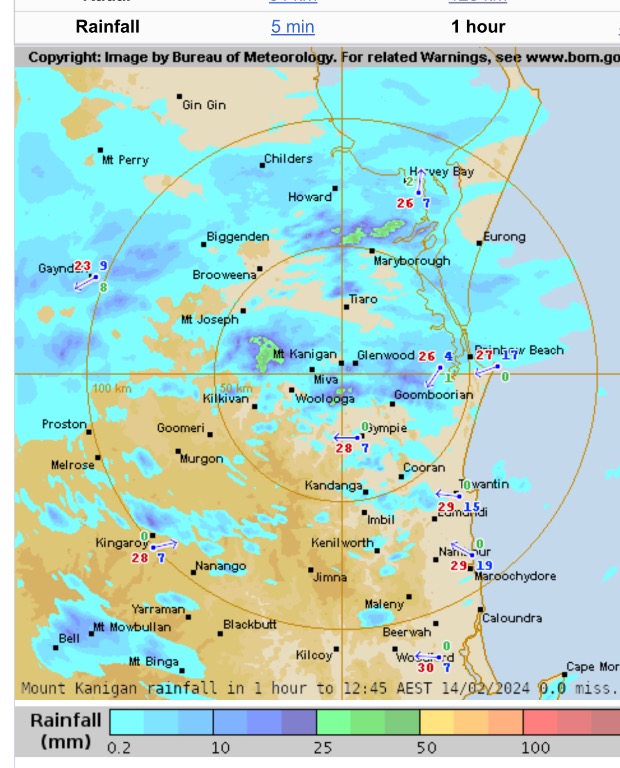 |
Colin Maitland. |
|
|
|
|
|
Rank: Advanced Member
Groups: Registered, Administrators Joined: 21/08/2019(UTC) Posts: 942 Location: Brisbane Northside Thanks: 1198 times
Was thanked: 1136 time(s) in 674 post(s)
|
Some decent cells/showers on the radar this afternoon. Due to the lack of steering winds they are moving slowly and dropping some good rain. A STW is out for Heavy Rain just to the west of here including the Darling Downs. 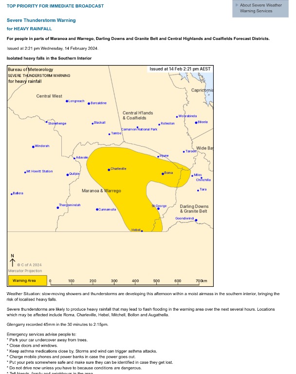   Edited by user Wednesday, 14 February 2024 3:06:17 PM(UTC)
| Reason: Not specified |
Colin Maitland. |
|
|
|
|
|
Rank: Advanced Member
Groups: Registered, Administrators Joined: 21/08/2019(UTC) Posts: 942 Location: Brisbane Northside Thanks: 1198 times
Was thanked: 1136 time(s) in 674 post(s)
|
So far Brisbane and surrounding suburbs have missed out on the storms, it may change as the evening approaches. But it was a slim chance for this area. I need to be more specific in areas when forecasting. Usually on a forum there are members in other areas of the thread that will input their areas weather and observations. But please feel welcome to join the forum. I try and keep everything as simple as possible. It is actually more fun to convert a technical observation and breakdown of an upcoming event into very simple terms. Weather has to be understood by all no matter what level you are at. So please join in if you would like. Here is the latest STW just to the West. 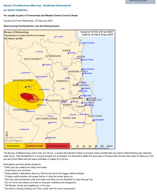 2 hours later and the radar is almost the same. Very slow moving cells.  |
Colin Maitland. |
|
|
|
|
|
Rank: Advanced Member
Groups: Registered, Administrators Joined: 21/08/2019(UTC) Posts: 942 Location: Brisbane Northside Thanks: 1198 times
Was thanked: 1136 time(s) in 674 post(s)
|
They were replacing power poles yesterday so I didn’t have power for most of the day. But today starts with a Severe Thunderstorm Warning for Heavy rain. Today will see some heavy rain at times. A trough over Eastern and Southern Queensland will strengthen today and a weak upper trough will cause heavy rainfall mainly towards the East. This should start to ease off over the weekend. The storm warning below with some of the rain totals. 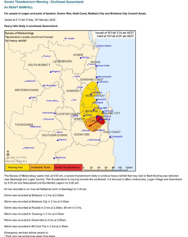   |
Colin Maitland. |
|
|
|
|
|
Rank: Advanced Member
Groups: Registered, Administrators Joined: 21/08/2019(UTC) Posts: 942 Location: Brisbane Northside Thanks: 1198 times
Was thanked: 1136 time(s) in 674 post(s)
|
A trough and associated upper thermal atmospheric conditions may increase shower and thunderstorm activity about the far southeast of the Queensland and NE NSW during Monday and Tuesday, with a risk of moderate to locally heavy falls. Most of the activity is more towards to Brisbane and the Southside, Ipswich and towards the border. Below is the Windy EC chart showing posslocations of storm in the afternoon. 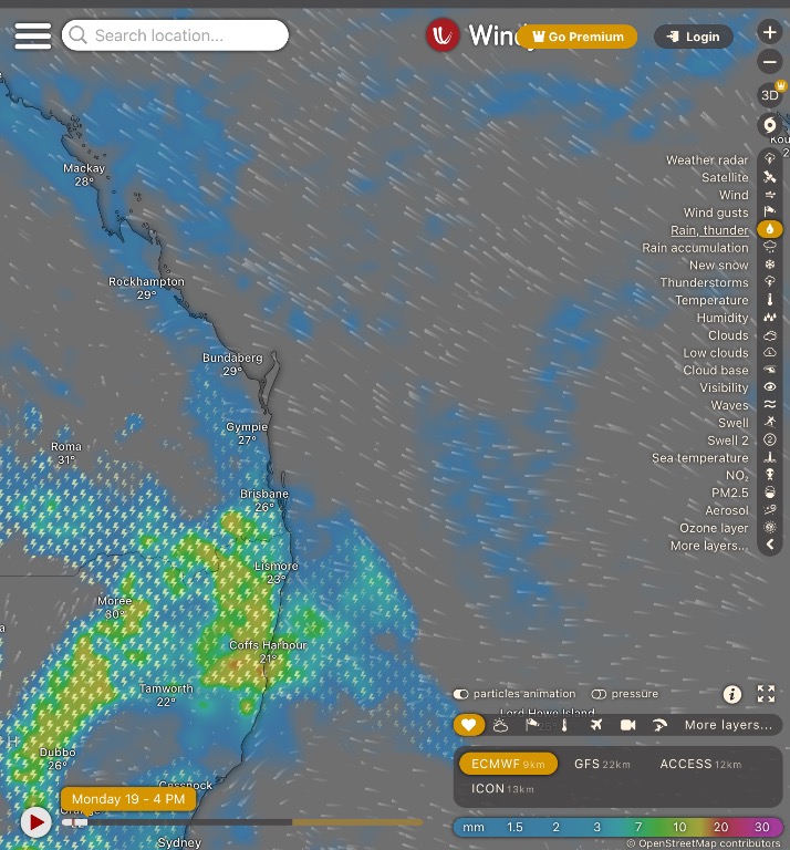 This is the forecast sounding but it will be a better indicator when the Sounding come in to tell us what is happening in the layers of the atmosphere. 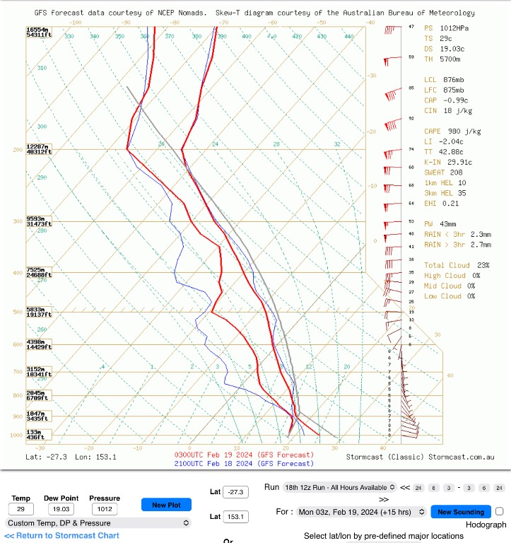 And below is meteye’s take on the possibility of storms. 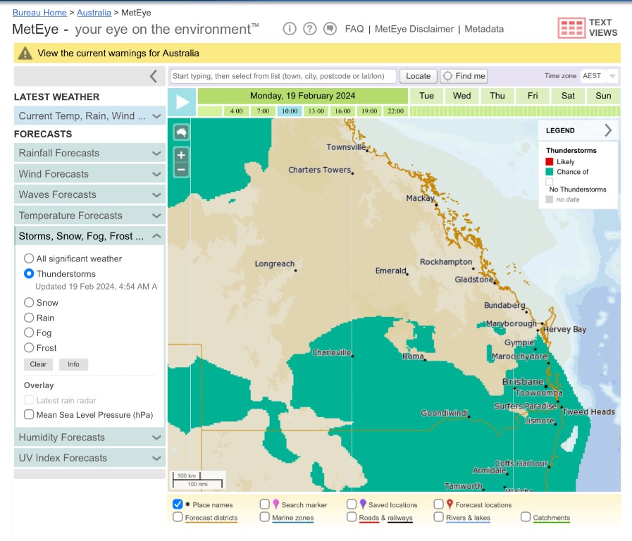 When I was running through the models I thought that Friday, which in terms of storms is a long way out at this point, looked a bigger storm day, so I will be keeping an eye open as the week progresses. |
Colin Maitland. |
|
|
|
|
|
Rank: Advanced Member
Groups: Registered, Administrators Joined: 21/08/2019(UTC) Posts: 942 Location: Brisbane Northside Thanks: 1198 times
Was thanked: 1136 time(s) in 674 post(s)
|
STW at 2:00 pm 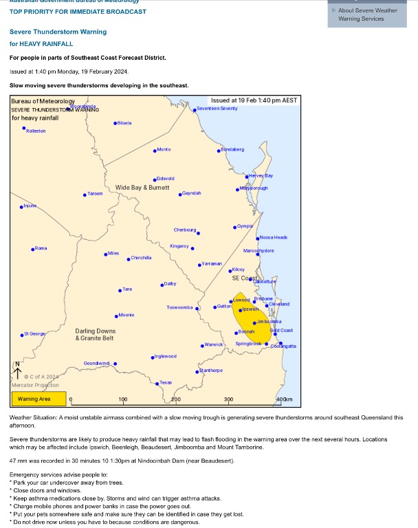 |
Colin Maitland. |
|
|
|
|
|
Rank: Advanced Member
Groups: Registered, Administrators Joined: 21/08/2019(UTC) Posts: 942 Location: Brisbane Northside Thanks: 1198 times
Was thanked: 1136 time(s) in 674 post(s)
|
Wednesday is once again looking like a repeat weather pattern as yesterday. A slim chance of isolated showers. Running through the models and there could be a storm on Friday but I am waiting on the next run, but Saturday is now looking the better of the two days to have the potential of some widespread storm activity. Below is just the storm possibilities without going into the setup as it could still change, but it shows the difference between the two days. I had earlier said that Friday was looking good for storms but would need to wait and see as it was some time out and sure enough it has changed. Friday 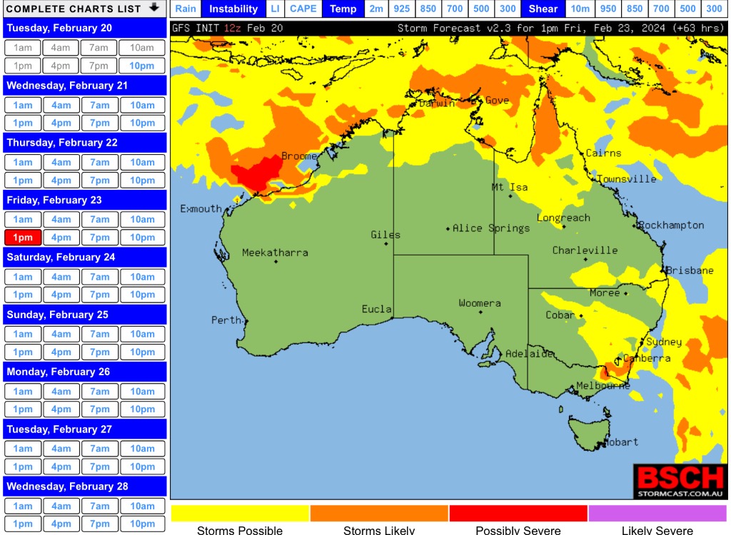 Saturday. 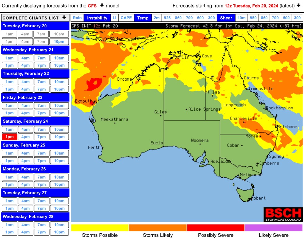 Once again just have to see the next runs to try and get a better idea of what is happening. |
Colin Maitland. |
 1 user thanked Colmait for this useful post.
|
|
|
|
Rank: Advanced Member
Groups: Registered, Administrators Joined: 21/08/2019(UTC) Posts: 942 Location: Brisbane Northside Thanks: 1198 times
Was thanked: 1136 time(s) in 674 post(s)
|
Over the last few days, no matter which way I looked at the modelling system there was no clear cut storm and the models had showers/rain ( saturated levels in the atmosphere appearing on the skewT. ) So today it looks like we could get showers and rain at times and maybe an embedded storm, possibly severe in places. Here is the charts from Yesterday with the sounding then the current t 512K radar sweep. 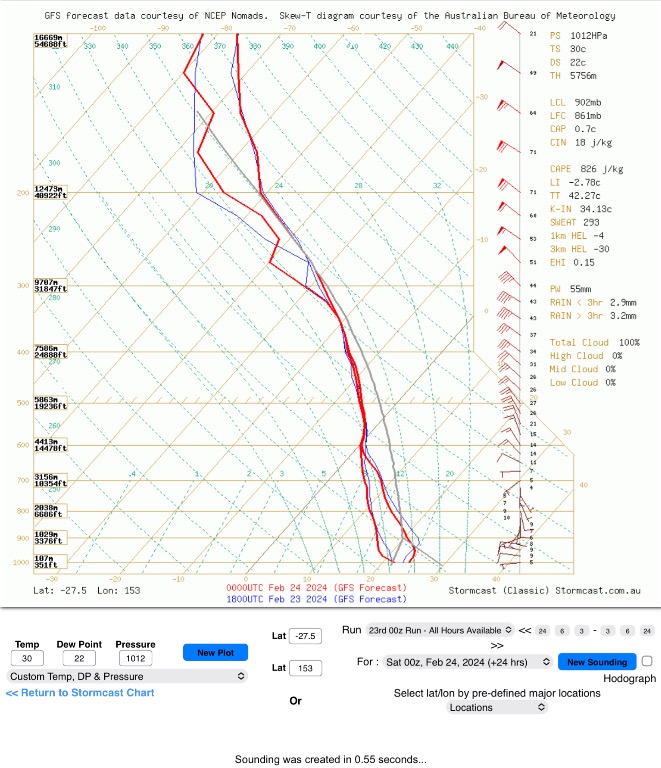   |
Colin Maitland. |
|
|
|
|
|
Rank: Advanced Member
Groups: Registered, Administrators Joined: 21/08/2019(UTC) Posts: 942 Location: Brisbane Northside Thanks: 1198 times
Was thanked: 1136 time(s) in 674 post(s)
|
|
Colin Maitland. |
|
|
|
|
|
Rank: Advanced Member
Groups: Registered, Administrators Joined: 21/08/2019(UTC) Posts: 942 Location: Brisbane Northside Thanks: 1198 times
Was thanked: 1136 time(s) in 674 post(s)
|
As the afternoon progresses more storms will develop within the rain train. The latest STW    |
Colin Maitland. |
|
|
|
|
|
Rank: Advanced Member
Groups: Registered, Administrators Joined: 21/08/2019(UTC) Posts: 942 Location: Brisbane Northside Thanks: 1198 times
Was thanked: 1136 time(s) in 674 post(s)
|
It is going to be above average temperatures for the beginning of Autumn. Temps. will sit in the low to mid 30’s as the week progresses with hopefully a slight reprieve for Monday.. I have just posted one chart for predicted temperatures as each day did not differ much for this thread area.  |
Colin Maitland. |
|
|
|
|
|
Rank: Advanced Member
Groups: Registered, Administrators Joined: 21/08/2019(UTC) Posts: 942 Location: Brisbane Northside Thanks: 1198 times
Was thanked: 1136 time(s) in 674 post(s)
|
Last day of summer today and it is still hot with temperatures in the 30’s. The beginning of Autumn is still on track as per the last post to remain hot and in the 30’s until next week.
It has been a hot, extremely humid summer along with many records broken all for the wrong reasons. The amount of moisture in the air with the perceptible water in a weather sounding was broken resulting in flash flooding with the storms and heavy rain. We had the most humid nights ever recorded with the feel like temperatures on many nights sitting in the low to mid 30’s. Day time temperatures had feel like temps of high 30 and some into the 40°C mark. This was all due to the moisture in the atmosphere giving us some of the highest dew points we have seen for a long time.
At this stage it does appear that we are tracking towards or back into a La Niña phase this Autumn/ Winter. So if it follows the trend we should see milder nights and cooler day time temperatures. But in saying that the weather pattern around the world has really bucked the trend and presented some extraordinary weather.
The best thing that we can do is be prepared for whatever is thrown at us, and the only way is to keep an eye and ear on the weather and look out for any extreme events that may arise and if they arise!
|
Colin Maitland. |
1 user thanked Colmait for this useful post.
|
|
|
|
Rank: Advanced Member
Groups: Registered, Administrators Joined: 21/08/2019(UTC) Posts: 942 Location: Brisbane Northside Thanks: 1198 times
Was thanked: 1136 time(s) in 674 post(s)
|
Another hot Autumn day but we may see a few showers and a possible storm or storms this afternoon in some areas of this thread. Some cells could be severe but just have to wait and see how it pans out. GFS is not fully on board with the idea yet but EC is predicting storms this afternoon. Below is the Windy storm and shower possibilities 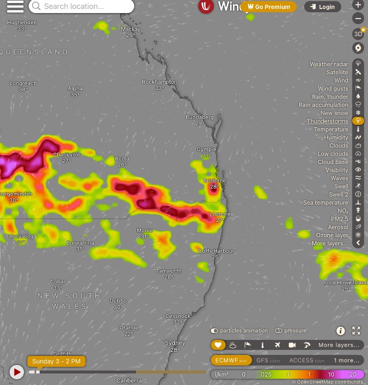  |
Colin Maitland. |
|
|
|
|
|
Rank: Advanced Member
Groups: Registered, Administrators Joined: 21/08/2019(UTC) Posts: 942 Location: Brisbane Northside Thanks: 1198 times
Was thanked: 1136 time(s) in 674 post(s)
|
|
Colin Maitland. |
|
|
|
|
|
Rank: Advanced Member
Groups: Registered, Administrators Joined: 21/08/2019(UTC) Posts: 942 Location: Brisbane Northside Thanks: 1198 times
Was thanked: 1136 time(s) in 674 post(s)
|
Once again another hot day yesterday and a very unpleasant night last night. Dew points pushed the feel like temperature way up and made for a very humid day/ night. Today looks a better setup for storms. Not all places within the thread will likely receive a storm but a better setup than yesterday. Below is the forecast sounding with plenty of instability. 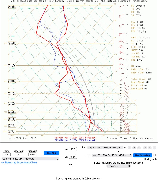 And below is just a quick look at the Li’s and the cape and area of possible storms.   |
Colin Maitland. |
|
|
|
|
|
Rank: Advanced Member
Groups: Registered, Administrators Joined: 21/08/2019(UTC) Posts: 942 Location: Brisbane Northside Thanks: 1198 times
Was thanked: 1136 time(s) in 674 post(s)
|
Latest STW 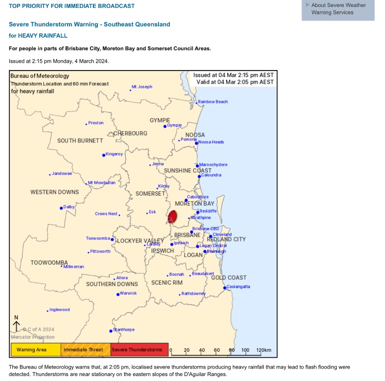 |
Colin Maitland. |
|
|
|
|
|
Rank: Advanced Member
Groups: Registered, Administrators Joined: 21/08/2019(UTC) Posts: 942 Location: Brisbane Northside Thanks: 1198 times
Was thanked: 1136 time(s) in 674 post(s)
|
Some wild weather over Moreton Bay this afternoon. Rotation can be seen on the doppler 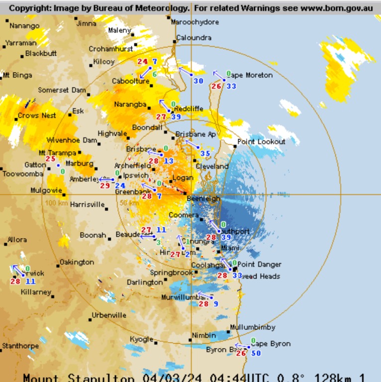 Resulting in social media coming alive with photos of water spouts over the bay  [ attach]2454[/attach]   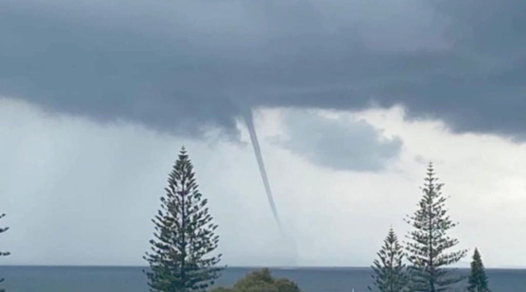 Edited by user Monday, 4 March 2024 3:02:31 PM(UTC)
| Reason: Not specified |
Colin Maitland. |
|
|
|
|
|
Rank: Advanced Member
Groups: Registered, Administrators Joined: 21/08/2019(UTC) Posts: 942 Location: Brisbane Northside Thanks: 1198 times
Was thanked: 1136 time(s) in 674 post(s)
|
Latest STW  |
Colin Maitland. |
|
|
|
|
|
Weather Forum
»
Australia Weather
»
SEQ and NE NSW
»
SE QLD and NE NSW - Day to day Weather 2024
Forum Jump
You cannot post new topics in this forum.
You cannot reply to topics in this forum.
You cannot delete your posts in this forum.
You cannot edit your posts in this forum.
You cannot create polls in this forum.
You cannot vote in polls in this forum.
Important Information:
The Weather Forum uses cookies. By continuing to browse this site, you are agreeing to our use of cookies.
More Details
Close
