Weather Forum

Welcome Guest! To enable all features please Login or Register.

Notification

Icon
Error

131 Pages«<4445464748>»
Share
Options
Go to last post Go to first unread
Offline Ken  
#901 Posted : Sunday, 15 December 2019 7:37:18 PM(UTC)
Ken

Rank: Advanced Member

Groups: Registered
Joined: 2/09/2019(UTC)
Posts: 105
Australia
Location: Brisbane

Thanks: 145 times
Was thanked: 561 time(s) in 103 post(s)
UserPostedImage

UserPostedImage


I finally had enough time to do a detailed write-up about Monday and posted it elsewhere so will copy and paste part of it here.

I should point out that Monday’s hot max temps are a bit tricky to forecast for some SEQ locations depending on the timing of the change and seabreeze.

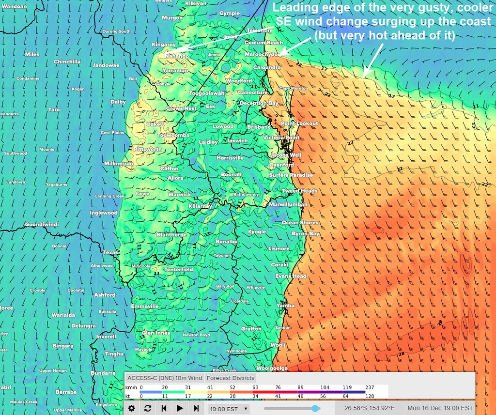
After a very hot day on Monday in SEQ (daytime max temps could be close to 10C hotter than the Dec average away from the coast and may even come close to breaking records in some locations), the good news is that a very gusty, cooler (read: less hot) SE wind change will start surging up the coast on Monday afternoon and bring down max temps closer to the Dec average for a few days although moreso near the coast. It’s unlikely to get as hot for parts of the coastal fringe and islands due to moderation by the afternoon seabreeze but it’s still likely to be significantly hotter than average.

Now for the bad news. Fire danger is expected to increase significantly on Monday in southeastern QLD especially the Downs and the wind change later in the day could pose an extra challenge for firefighters trying to control any existing or new fires.

Also later this week and into the early part of the weekend, max temps are likely to gradually heat up again especially inland and become hotter than the December average…. and on top of that, modelling is still going for the overall very dry weather pattern to continue through most of this week into the weekend for SEQ…. with the recent thunderstorms for the places that got them, only being a brief interruption to this regime. Jan and Feb currently have more uncertainty to them however.

So far this month, every day out of the past 34 days in Brisbane has featured max temps warmer than their respective monthly average and 10 of those have been more than 4C above average. Min temps have been more of a mixed bag although on average, they too have been a bit above the monthly mean.

And now for some good news again. At this stage, SEQ appears likely to be spared the worst of the extreme heat about to spread across large areas of the continent this week (this heat is likely to challenge or break records across a big number of locations where temps are likely to reach into the top 1% of hottest Dec days in the past).... as long as our region has N to NE winds rather than hotter westerly winds from inland keeping out the afternoon seabreezes.

CAUSE:
* The cause of our heat on Monday is warm NW winds followed by SW winds coming up from inland and keeping the seabreeze out from all but near-coastal areas before the cooler change surges up. The airmass itself is also generally very warm through the low to middle atmosphere.
* The reason why Monday’s max temps are a bit tricky to forecast for some locations is because they partly depend on the timing of the cooler coastal wind change and the position of the afternoon seabreeze front. This can make the difference between forecast max temps being spot on… or a number of degrees in error.
Brisbane is especially notorious for being tricky to forecast max temps for on hot days because of its location where even just a small difference in the timing of the seabreeze can make a big difference to whether or not the forecast max temp is reached before the seabreeze comes in.
* Forecast confidence is higher for locations away from the leading edge of the seabreeze and the wind change by the time peak heating’s reached during the day.

THE GUSTY COOLER CHANGE:
* At time of writing, modelling suggests the change is likely to reach the southern Gold Coast in the early afternoon, the Brisbane area around mid afternoon, and the Sunshine Coast in the late afternoon… but allow a bit of leeway for the timings there.
* Many of you might also notice it suddenly become quite windy as the change surges through and some of the gusty winds may hang around at times during the day on Tuesday as well.
* It’s hard to say whether a roll cloud will form along the leading edge of the coastal change but if any of you do manage to take a photo of one, please share!

MAX TEMPS:
* Monday's max temps are likely to range from the low 40s at inland locations east of the ranges, the high 30s between inland and coastal areas, and low to mid 30’s near the coastal fringe…. but remember that it’s possible some of these may be in error for locations near the leading edge of the seabreeze or coastal change if either arrives earlier or later than expected.

The map above via Weatherzone shows the forecast wind speeds and directions from the ACCESS-C model for early Monday evening.
P.S. the first image is the 2-week max temp scenarios for Amberley from the NCEP ensemble.
thanks 10 users thanked Ken for this useful post.
KellyT on 15/12/2019(UTC), DelBoy on 15/12/2019(UTC), SunSpots on 15/12/2019(UTC), Pabloako on 15/12/2019(UTC), SatMan on 15/12/2019(UTC), CantSpellNarangba on 15/12/2019(UTC), Falling_Droplet on 15/12/2019(UTC), Colmait on 16/12/2019(UTC), retired weather man on 16/12/2019(UTC), Greg on 16/12/2019(UTC)
Offline KellyT  
#902 Posted : Sunday, 15 December 2019 8:35:03 PM(UTC)
KellyT

Rank: Newbie

Groups: Registered
Joined: 12/12/2019(UTC)
Posts: 6
Australia
Location: Ningi

Thanks: 5 times
Was thanked: 20 time(s) in 5 post(s)
What an amazing writeup and charts. ThanK you Ken.

Although it may take me a few reads to comprehend it! Although I may impress the hubby if I pop a few of your thoughts into a sentence.

Thank you!
thanks 9 users thanked KellyT for this useful post.
DelBoy on 15/12/2019(UTC), SunSpots on 15/12/2019(UTC), Pabloako on 15/12/2019(UTC), SatMan on 15/12/2019(UTC), Ken on 15/12/2019(UTC), CantSpellNarangba on 15/12/2019(UTC), Falling_Droplet on 15/12/2019(UTC), Colmait on 16/12/2019(UTC), retired weather man on 16/12/2019(UTC)
Offline Pabloako  
#903 Posted : Sunday, 15 December 2019 8:39:08 PM(UTC)
Pabloako

Rank: Advanced Member

Groups: Registered
Joined: 21/08/2019(UTC)
Posts: 185
Australia
Location: Ocean View

Thanks: 359 times
Was thanked: 539 time(s) in 161 post(s)
Originally Posted by: Ken Go to Quoted Post
Originally Posted by: CantSpellNarangba Go to Quoted Post
No more rain and oven like conditions return next week.
38°C Monday, 30s for the rest of the week and 35°C on Friday.

:-(


Yeah to say it's relentless would be an understatement.


These are my rain totals since May. They are amazingly low.


27mm May,
36mm Jun,
19mm Jul,
4mm Aug,
12mm Sep,
31mm Oct,
12mm Nov.
6mm Dec (so far)

Crazy.


thanks 6 users thanked Pabloako for this useful post.
SatMan on 15/12/2019(UTC), Ken on 15/12/2019(UTC), CantSpellNarangba on 15/12/2019(UTC), Falling_Droplet on 15/12/2019(UTC), Colmait on 16/12/2019(UTC), retired weather man on 16/12/2019(UTC)
Offline Falling_Droplet  
#904 Posted : Sunday, 15 December 2019 11:13:01 PM(UTC)
Falling_Droplet

Rank: Advanced Member

Groups: Registered
Joined: 25/08/2019(UTC)
Posts: 1,839
Australia
Location: Ferny Grove

Thanks: 985 times
Was thanked: 856 time(s) in 419 post(s)
A warm day with a maximum temperature of 34.3 C that was reached in the late morning. In the afternoon the temperature was rather variable until mid afternoon while generally falling. Dew point rose a little in the the morning and was moderately high (a high of 21 C) at times before falling in the afternoon back to near average. Tonight the dew point have started to rise close to average. Near average relative humidity during today. Light E to NE winds in the morning, became ESE to ENE later in the morning, E to ESE in the afternoon, E to NE from mid afternoon and N to NE tonight.

Last 24 hours:
temp 2019-12-15.PNGwind dir 2019-12-15.PNG
thanks 2 users thanked Falling_Droplet for this useful post.
Colmait on 16/12/2019(UTC), retired weather man on 16/12/2019(UTC)
Offline Colmait  
#905 Posted : Monday, 16 December 2019 6:27:32 AM(UTC)
Colmait

Rank: Advanced Member

Groups: Registered
Joined: 21/08/2019(UTC)
Posts: 493
Australia
Location: Brisbane Northside

Thanks: 1040 times
Was thanked: 692 time(s) in 247 post(s)
Good to see you on here again KenThumpUp . Nice summary.

Fortunately being near the Bay at Bracken Ridge and on the Eastern side of the Ridge, we max our at 36°C if everything sticks to the forecast, but it is way above the norm for us as Ken highlighted.

Hot ,dry and windy, what a recipe for severe fire. When the cooling wind change arrives that is the Firefighters nightmare. The wind gusts are stronger and the direction changes and therefore any fires burning become unpredictable and even more dangerous.

Stanthorpe 36°C with late gusty winds
Warwick 40°C with late gusty winds
Toowoomba 38°C with late gusty winds.
But Ipswich is unfortunately going to cop the brunt of the system with a windy day and 43°C.
Colin Maitland.
thanks 4 users thanked Colmait for this useful post.
Ken on 16/12/2019(UTC), Falling_Droplet on 16/12/2019(UTC), retired weather man on 16/12/2019(UTC), CantSpellNarangba on 16/12/2019(UTC)
Offline Falling_Droplet  
#906 Posted : Monday, 16 December 2019 7:52:16 AM(UTC)
Falling_Droplet

Rank: Advanced Member

Groups: Registered
Joined: 25/08/2019(UTC)
Posts: 1,839
Australia
Location: Ferny Grove

Thanks: 985 times
Was thanked: 856 time(s) in 419 post(s)

Ferny Grove Weather
Date: 16 Dec 2019
Time: 7:35 AM

Min Temp since 9am yesterday: 20.1 C
Max Temp since 9am yesterday: 34.3 C
Min Ground Temp: 17.9 C
Rain since 9am yesterday: 0 mm

Temperature: 26.6 C
Relative Humidity: 61 %
Dew Point: 18.5 C
MSL Pressure: 1008.6 hPa
Wind Speed: 3kph - light air
Wind Direction: SE

Present Weather: Smoke Haze
Visibility: 20km to 39km - Very Good Visibility
Cloud Cover: 1/8
Ground State: Ground dry

Notes of yesterday weather - 15/12/19: Partly cloudy with cu and sc clouds in the afternoon with ci clouds in the afternoon. Fine with smoke haze. A warm day with the maximum temperature reached in the late morning before falling in the afternoon, though was variable from early afternoon to mid afternoon. Dew point was stable and near average early in the day, before rising during the morning and became moderately high during the middle of the day. From the afternoon the dew point fell and returned to near average. Relative humidity was near average. Mostly calm winds early in the day with E to NE winds with some N to NE winds at times, ESE to ENE later in the morning, E to ESE in the afternoon, E to NE from mid afternoon and N to NE in the evening becoming calm in the late evening.

Today: Temperature is near average. Dew point have been near average and generally stable. Relative humidity have been near average. Calm winds today with E to NE becoming S to SSE since 7:30am.
thanks 3 users thanked Falling_Droplet for this useful post.
retired weather man on 16/12/2019(UTC), CantSpellNarangba on 16/12/2019(UTC), Colmait on 16/12/2019(UTC)
Offline retired weather man  
#907 Posted : Monday, 16 December 2019 8:25:06 AM(UTC)
retired weather man

Rank: Advanced Member

Groups: Registered
Joined: 21/08/2019(UTC)
Posts: 182
Australia
Location: Wynnum North

Thanks: 656 times
Was thanked: 381 time(s) in 167 post(s)
WYNNUM NORTH ( 27.4S 153.2E ) - WEATHER

DATE...16 DEC 2019 TIME....0820

CURRENT TEMPERATURE...28.3C
CURRENT HUMIDITY........71%
CURRENT DEW POINT.......23C
CURRENT WIND DIR/SPEED..NW 11Kph
CURRENT VISIBILITY......25KM
CURRENT MSL PRESSURE...1008.5Hpa
CURRENT CLOUD..........4/8 Ci
CURRENT WEATHER......Smoke haze
RAIN SINCE 0900 SUNDAY...0.0mm

SUMMARY LAST 24 HOURS
YESTERDAY'S MAX TEMP.........31.2C
THIS MORNING'S MIN TEMP......23.5C
PAST 24 HOURS TEMP ANOMALY..+2.95C
THIS MORNING'S GRASS MIN.....22.4C
AVERAGE 24 HOUR DEW POINT......23C ( Max 26C )
AVERAGE 24 HOUR MSLP........1008.4Hpa
PAST 24 HOURS MAX WIND GUST...N 40Kph at 1510
PAST 24 HR SIGNIFICANT WEATHER...Smoke haze.
Wyn Nth 2020-Jan165,
thanks 2 users thanked retired weather man for this useful post.
Colmait on 16/12/2019(UTC), Falling_Droplet on 16/12/2019(UTC)
Offline CantSpellNarangba  
#908 Posted : Monday, 16 December 2019 8:34:19 AM(UTC)
CantSpellNarangba

Rank: Advanced Member

Groups: Registered
Joined: 23/08/2019(UTC)
Posts: 155
Australia
Location: Narangba

Thanks: 280 times
Was thanked: 442 time(s) in 136 post(s)
My goodness. 8:25am and it is 33 degress here in Narangba
Confused ThumbDown OhMyGod
thanks 4 users thanked CantSpellNarangba for this useful post.
SatMan on 16/12/2019(UTC), Colmait on 16/12/2019(UTC), Falling_Droplet on 16/12/2019(UTC), retired weather man on 17/12/2019(UTC)
Offline Pabloako  
#909 Posted : Monday, 16 December 2019 12:04:57 PM(UTC)
Pabloako

Rank: Advanced Member

Groups: Registered
Joined: 21/08/2019(UTC)
Posts: 185
Australia
Location: Ocean View

Thanks: 359 times
Was thanked: 539 time(s) in 161 post(s)
Here is an image generated from BOM data, showing temperatures around SEQ at 11:10am. Rather warm!
On a slight side note, this morning's (12z) GFS has the southerly change at Brisbane at around 5:30pm to 6pm, which is also echoed in Ken's images above.


LargeLocalTempGrad.png

Edited by user Monday, 16 December 2019 12:11:15 PM(UTC)  | Reason: Not specified

thanks 3 users thanked Pabloako for this useful post.
Colmait on 16/12/2019(UTC), Falling_Droplet on 16/12/2019(UTC), retired weather man on 17/12/2019(UTC)
Offline SatMan  
#910 Posted : Monday, 16 December 2019 12:21:41 PM(UTC)
SatMan

Rank: Advanced Member

Groups: Registered
Joined: 7/09/2019(UTC)
Posts: 67
Australia
Location: Brisbane

Thanks: 113 times
Was thanked: 207 time(s) in 61 post(s)
A few fires are still around our region. (Image from 10 minutes ago)

Untitled2.jpg
thanks 3 users thanked SatMan for this useful post.
Colmait on 16/12/2019(UTC), Falling_Droplet on 16/12/2019(UTC), retired weather man on 17/12/2019(UTC)
Offline DelBoy  
#911 Posted : Monday, 16 December 2019 1:03:43 PM(UTC)
DelBoy

Rank: Advanced Member

Groups: Registered
Joined: 13/09/2019(UTC)
Posts: 118
Location: Caboolture (the next Las Vegas!)

Thanks: 215 times
Was thanked: 297 time(s) in 100 post(s)
Some current temps around our area.

Capture.JPG
thanks 3 users thanked DelBoy for this useful post.
Colmait on 16/12/2019(UTC), Falling_Droplet on 16/12/2019(UTC), retired weather man on 17/12/2019(UTC)
Offline DelBoy  
#912 Posted : Monday, 16 December 2019 1:05:41 PM(UTC)
DelBoy

Rank: Advanced Member

Groups: Registered
Joined: 13/09/2019(UTC)
Posts: 118
Location: Caboolture (the next Las Vegas!)

Thanks: 215 times
Was thanked: 297 time(s) in 100 post(s)
.. and 10 minutes later!

Capture.JPG
thanks 3 users thanked DelBoy for this useful post.
Colmait on 16/12/2019(UTC), Falling_Droplet on 16/12/2019(UTC), retired weather man on 17/12/2019(UTC)
Offline Colmait  
#913 Posted : Monday, 16 December 2019 2:06:29 PM(UTC)
Colmait

Rank: Advanced Member

Groups: Registered
Joined: 21/08/2019(UTC)
Posts: 493
Australia
Location: Brisbane Northside

Thanks: 1040 times
Was thanked: 692 time(s) in 247 post(s)
Brisbane hit 41.2°C at 13:40 this afternoon.

That is hot, The temp seems to be dropping as the wind direction is starting to shift to the South. Thanks to the smoke doppler is able to pick up a fair area and you can see the change starting to come through.
Colin Maitland.
thanks 4 users thanked Colmait for this useful post.
Pabloako on 16/12/2019(UTC), Falling_Droplet on 16/12/2019(UTC), Paul Atkins on 16/12/2019(UTC), retired weather man on 17/12/2019(UTC)
Offline Pabloako  
#914 Posted : Monday, 16 December 2019 3:54:15 PM(UTC)
Pabloako

Rank: Advanced Member

Groups: Registered
Joined: 21/08/2019(UTC)
Posts: 185
Australia
Location: Ocean View

Thanks: 359 times
Was thanked: 539 time(s) in 161 post(s)
Lovely Easterly wind here now has reduced the temps a bit.
I got to 40.3°C here today, which is a record since I have been here.
thanks 3 users thanked Pabloako for this useful post.
Colmait on 16/12/2019(UTC), Falling_Droplet on 16/12/2019(UTC), retired weather man on 17/12/2019(UTC)
Offline Colmait  
#915 Posted : Monday, 16 December 2019 4:15:03 PM(UTC)
Colmait

Rank: Advanced Member

Groups: Registered
Joined: 21/08/2019(UTC)
Posts: 493
Australia
Location: Brisbane Northside

Thanks: 1040 times
Was thanked: 692 time(s) in 247 post(s)
Originally Posted by: Pabloako Go to Quoted Post
Lovely Easterly wind here now has reduced the temps a bit.
I got to 40.3°C here today, which is a record since I have been here.


It may even be a December Record up there Pabloaka.

Brisbane’s 41.2°C at 13:40 equalled its record set in 1981 as the hottest December day.
Some very hot temps out in some areas today. The wind here is gusting up to 50+ km/h and Archerfield is gusting at 72 km/h.

Edited by user Monday, 16 December 2019 4:18:43 PM(UTC)  | Reason: Fixed something,

Colin Maitland.
thanks 5 users thanked Colmait for this useful post.
Falling_Droplet on 16/12/2019(UTC), Paul Atkins on 16/12/2019(UTC), Pabloako on 16/12/2019(UTC), retired weather man on 17/12/2019(UTC), DelBoy on 17/12/2019(UTC)
Offline Pabloako  
#916 Posted : Monday, 16 December 2019 7:04:02 PM(UTC)
Pabloako

Rank: Advanced Member

Groups: Registered
Joined: 21/08/2019(UTC)
Posts: 185
Australia
Location: Ocean View

Thanks: 359 times
Was thanked: 539 time(s) in 161 post(s)
The Banana farms and winery up here are not having a good time with this weather.

Looking at forecasts, still no rain forecast for at lease 9+ days.

Crazy
thanks 4 users thanked Pabloako for this useful post.
Colmait on 16/12/2019(UTC), Falling_Droplet on 16/12/2019(UTC), retired weather man on 17/12/2019(UTC), DelBoy on 17/12/2019(UTC)
Offline Falling_Droplet  
#917 Posted : Monday, 16 December 2019 9:33:46 PM(UTC)
Falling_Droplet

Rank: Advanced Member

Groups: Registered
Joined: 25/08/2019(UTC)
Posts: 1,839
Australia
Location: Ferny Grove

Thanks: 985 times
Was thanked: 856 time(s) in 419 post(s)
The maximum temperature at my location was 42.8 C at 1 pm. This is a new record high for both December and any month for the last 10 years of records. The temperature rose at 4 to 5 C per hour between 6am and 10am before rising to 40.0 C at 10:50 am and rose at a slower rate from 10am to the maximum in the early afternoon. The temperature fell 2 C to 40 C with the wind change and gradually during the rest of the afternoon before falling slowly tonight close to average. Dew point fell slowly during the morning close to average before sharply falling from 9:50 am and generally at a slower rate 10 minutes later for the rest of the morning close to 0 C. In the afternoon the dew point fell further to a low of -12 C. The dew point rose sharply in the early afternoon rising from -0.8 C at 1:17pm to 12.7 C at 1:19pm with the wind change. Following this the dew point was moderately low and fell slowly, rose slowly in the late afternoon and have been near average and stable tonight.

Relative humidity fell quite quickly during the morning from a maximum of 80 % at 5:30 am to 29% at 9:50am, before falling at a faster rate for 10 minutes to 10% and then at a slower rate to a low of 3% in the early afternoon. The relative humidity rose quickly with the wind change in the early afternoon(rising 12% in 2 minutes), before remaining low and stable following this before rising slowly from 4pm. Relative humidity rose much slower tonight and is moderately low. Light SE to SW winds with some SE to NE winds in the morning became W to SW from 9:50 am with some S to SW winds. In the middle of the day was NW to SW winds before a light to moderate E to SE wind change from 1:12pm with some E to ENE winds. Winds tended S to SE tonight.
thanks 1 user thanked Falling_Droplet for this useful post.
retired weather man on 17/12/2019(UTC)
Offline Falling_Droplet  
#918 Posted : Monday, 16 December 2019 9:52:17 PM(UTC)
Falling_Droplet

Rank: Advanced Member

Groups: Registered
Joined: 25/08/2019(UTC)
Posts: 1,839
Australia
Location: Ferny Grove

Thanks: 985 times
Was thanked: 856 time(s) in 419 post(s)
Month to date maximum temperature for the month to date is 35 C (5 C above average) at my location. Overnight temperatures have however been near average.

This is the month to date anomalies for my location as of 9am today for temperature and rain and midnight this morning otherwise.

MTD 12-2019.PNG
thanks 3 users thanked Falling_Droplet for this useful post.
retired weather man on 17/12/2019(UTC), DelBoy on 17/12/2019(UTC), Colmait on 17/12/2019(UTC)
Offline Falling_Droplet  
#919 Posted : Monday, 16 December 2019 11:50:28 PM(UTC)
Falling_Droplet

Rank: Advanced Member

Groups: Registered
Joined: 25/08/2019(UTC)
Posts: 1,839
Australia
Location: Ferny Grove

Thanks: 985 times
Was thanked: 856 time(s) in 419 post(s)
thanks 2 users thanked Falling_Droplet for this useful post.
retired weather man on 17/12/2019(UTC), Colmait on 17/12/2019(UTC)
Offline Pabloako  
#920 Posted : Tuesday, 17 December 2019 7:42:35 AM(UTC)
Pabloako

Rank: Advanced Member

Groups: Registered
Joined: 21/08/2019(UTC)
Posts: 185
Australia
Location: Ocean View

Thanks: 359 times
Was thanked: 539 time(s) in 161 post(s)
Yesterday was my hottest temperature of the month and this morning was my lowest temperature of the month at 17.9°C. Loving the cooler start to the day!
thanks 3 users thanked Pabloako for this useful post.
retired weather man on 17/12/2019(UTC), Falling_Droplet on 17/12/2019(UTC), Colmait on 17/12/2019(UTC)
Users browsing this topic
Guest (6), Bingbot
Similar Topics
SE QLD and NE NSW - Day to day Weather 2024 (SEQ and NE NSW)
by Colmait 29/12/2023 10:05:34 AM(UTC)
131 Pages«<4445464748>»
Forum Jump  
You cannot post new topics in this forum.
You cannot reply to topics in this forum.
You cannot delete your posts in this forum.
You cannot edit your posts in this forum.
You cannot create polls in this forum.
You cannot vote in polls in this forum.

Weather Forum

Weatherzone Forum Alternative

The Weather Forum for Australia

Australian Weather Forum

Weather Forum for Australia, climate change, storm chasing, cyclones, weather photography