Weather Forum
»
Australia Weather
»
SEQ and NE NSW
»
SE QLD and NE NSW - Day to Day Weather
Rank: Advanced Member
Groups: Registered
Joined: 25/08/2019(UTC) Posts: 1,839  Location: Ferny Grove Thanks: 985 times
Was thanked: 856 time(s) in 419 post(s)
|
Ferny Grove Weather
Date: 26 Feb 2020
Time: 8:00 AM
Min Temp since 9am yesterday: 0.6 C
Max Temp since 9am yesterday: 29 C
Min Ground Temp: 19.8 C
Rain since 9am yesterday: 0.2 mm
Temperature: 24.8 C
Relative Humidity: 75 %
Dew Point: 20 C
MSL Pressure: 1011.6 hPa
Wind Speed: 6 kph - light breeze
Wind Direction: SSW
Present Weather: Clouds generally forming or developing during the preceding hour
Visibility: 20km to 39km - Very Good Visibility
Cloud Cover: 3/8
Ground State: Ground moist
Notes of yesterday weather - 25/2/20: Cloudy periods with cu, sc and as clouds. A light shower at 1am, very light brief showers in the late morning and a light shower in the evening. A cool day with the temperature a little variable during the afternoon. Close to average and stable dew point early in the day before rising during the morning, became stable from the late morning and slowly fell in the afternoon whilst remaining close to average. In the late afternoon the dew point slowly rose before starting to fall close to average later in the evening. Moderately high day-time relative humidity and otherwise near average. Light SSW to WSW winds early in the day becoming S to SE in the morning, ESE to SSE from the late morning and SSE to SE in the late afternoon. Early in the evening winds were SSE to ESE, S to SW from 8pm and then became calm for the rest of the evening.
Today: The dew point fell in the early hours before starting to rise this morning close to average. Relative humidity have been near average. Light SSW to SW winds between 2am and 3am and otherwise calm before WSW to SW winds in the last hour.
|
|
 1 user thanked Falling_Droplet for this useful post.
|
|
|
|
Rank: Advanced Member
Groups: Registered
Joined: 25/08/2019(UTC) Posts: 1,839 Location: Ferny Grove Thanks: 985 times
Was thanked: 856 time(s) in 419 post(s)
|
|
|
1 user thanked Falling_Droplet for this useful post.
|
|
|
|
Rank: Advanced Member
Groups: Registered, Administrators Joined: 21/08/2019(UTC) Posts: 941 Location: Brisbane Northside Thanks: 1198 times
Was thanked: 1136 time(s) in 674 post(s)
|
A solid chunky cell spanning from Stanthorpe to Harrisville this morning. Watching a few sweeps of the radar and there is some very nice rotation within the cell which is also evident on the doppler. Fortunately the winds are not too strong. Storms predicted for today so I will be trying to keep an eye on any that may form. Have a few things to juggle around. Yesterday was very interesting weather wise at Bracken Ridge. I had an errand to run and was at the Bracken Ridge shopping centre. It started to rain, but as I walked out of the centre I was hit with some of the hottest humidity I have felt for a long time even though there was rain. It was extremely oppressive for a couple of hours. There is a lot of energy building in the atmosphere and if today, or very shortly, this repeated itself with the right favourable conditions we will have one massive supercell hit. Below is the radar for this morning’s cell as discussed above. If we get clear skies and solid heating we could see some action later. I am a bit short of time to put up the charts and soundings. If I get time in between jobs I will try and do so.    |
Colin Maitland. |
1 user thanked Colmait for this useful post.
|
|
|
|
Rank: Advanced Member
Groups: Registered
Joined: 25/08/2019(UTC) Posts: 1,839 Location: Ferny Grove Thanks: 985 times
Was thanked: 856 time(s) in 419 post(s)
|
Ferny Grove Weather
Date: 27 Feb 2020
Time: 8:00 AM
Min Temp since 9am yesterday: 23.1 C
Max Temp since 9am yesterday: 31.8 C
Min Ground Temp: 22 C
Rain since 9am yesterday: 0.1 mm
Temperature: 26.9 C
Relative Humidity: 74 %
Dew Point: 21.4 C
MSL Pressure: 1007.6 hPa
Wind Speed: 3 kph - light air
Wind Direction: SW
Present Weather: State of sky generally unchanged during preceding hour
Visibility: 20km to 39km - Very Good Visibility
Cloud Cover: 3/8
Ground State: Ground moist
Notes of yesterday weather - 26/2/20: Mostly cloudy with cu, sc and as clouds. A late afternoon brief light shower. The dew point fell early in the day before rising during the morning and became moderately and before becoming stable from the late morning for the remainder of the day returning to near average from the afternoon. Relative humidity was near average early in the day and in the evening and moderately high from the morning to the late afternoon. Light SSW to SW winds during some of the early hours before WSW to SW winds during the morning, ENE to SE in the morning before N to NE becoming NE to SE later in the morning. In the afternoon winds were E to SE, becoming E to NE and then N to NE in the evening.
Today: Clam winds today becoming S to SSW and E to NE in the last 30 minutes. Warm overnight. The dew point have been near average and stable before starting to rise this morning. Relative humidity have been near average.
|
|
1 user thanked Falling_Droplet for this useful post.
|
|
|
|
Rank: Advanced Member
Groups: Registered, Administrators Joined: 21/08/2019(UTC) Posts: 941 Location: Brisbane Northside Thanks: 1198 times
Was thanked: 1136 time(s) in 674 post(s)
|
Sounding is out and I have a few minutes to post. There is total saturation levels at 650 - 520 mb. There is no cap so storms could fire off very quickly. The is an enormous amount of instability in the atmosphere So the scenarios could be a case of storm embedded showers but still could see storms build this afternoon. tonight. With the amount of instability there could be a few severe storms around. It will be a case of watch and see. 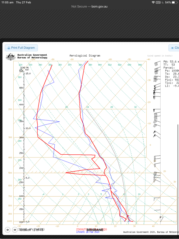 Edited by user Thursday, 27 February 2020 11:13:51 AM(UTC)
| Reason: Forgot to add stability factor |
Colin Maitland. |
1 user thanked Colmait for this useful post.
|
|
|
|
Rank: Advanced Member
Groups: Registered, Administrators Joined: 21/08/2019(UTC) Posts: 941 Location: Brisbane Northside Thanks: 1198 times
Was thanked: 1136 time(s) in 674 post(s)
|
Scattered storms in the peppered cells showing on the radar ATM. Here is an image from the lightning tracker. Due to Weatherzones disgusting act to close the weather forum and many others I didn’t realise they had control of, I did not renew my proscript and give them $60.00. So I am playing around with other models etc. This is the current lightning that is present at 12:00pm. Although it says 1:00 pm daylighy saving.  |
Colin Maitland. |
1 user thanked Colmait for this useful post.
|
|
|
|
Rank: Advanced Member
Groups: Registered, Administrators Joined: 21/08/2019(UTC) Posts: 941 Location: Brisbane Northside Thanks: 1198 times
Was thanked: 1136 time(s) in 674 post(s)
|
|
Colin Maitland. |
1 user thanked Colmait for this useful post.
|
|
|
|
Rank: Advanced Member
Groups: Registered, Administrators Joined: 21/08/2019(UTC) Posts: 941 Location: Brisbane Northside Thanks: 1198 times
Was thanked: 1136 time(s) in 674 post(s)
|
At approximately 16:00 the area around Harrisville towards Greenbank I believe is the area for around Brisbane to keep a watch on. As you have seen there has been no cap and the cells have just exploded today. We have had over 25 mm. See below for the watch area where storms should start to build again. The Kilkoy cell now has a nice solid black core. 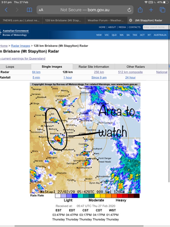 Edited by user Thursday, 27 February 2020 4:06:12 PM(UTC)
| Reason: Speilink |
Colin Maitland. |
1 user thanked Colmait for this useful post.
|
|
|
|
Rank: Advanced Member
Groups: Registered, Administrators Joined: 21/08/2019(UTC) Posts: 941 Location: Brisbane Northside Thanks: 1198 times
Was thanked: 1136 time(s) in 674 post(s)
|
STW from BoM 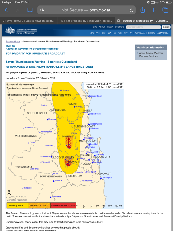 The Bureau of Meteorology warns that, at 4:00 pm, severe thunderstorms were detected on the weather radar. Thunderstorms are moving towards the north. They are forecast to affect northern Lake Wivenhoe by 4:30 pm and Grandchester and Somerset Dam by 5:00 pm. Damaging winds, heavy rainfall that may lead to flash flooding and large hailstones are likely. |
Colin Maitland. |
1 user thanked Colmait for this useful post.
|
|
|
|
Rank: Advanced Member
Groups: Registered
Joined: 25/08/2019(UTC) Posts: 1,839 Location: Ferny Grove Thanks: 985 times
Was thanked: 856 time(s) in 419 post(s)
|
A mild and brief thunderstorm at 3:20pm with some moderate falls and a total of 1 mm. The thunderstorm moved in from the south and decayed as it moved through. A near average maximum temperature today was reached in the middle of the day with the temperature a bit variable in the late morning and in the afternoon. In the afternoon the temperature fell before becoming generally stable following the storm. In the mid morning the temperature became stable. The dew point slowly rose during the morning and became moderately high before becoming stable from the late morning, falling during the afternoon before the storm back to near average before rising slightly following the storm. From 4pm the dew point slowly fell. Relative humidity have been variable today, moderately high during the daytime and near average tonight. Light N to ENE winds during the morning and became SE to SW in the late morning and S to SE in the early afternoon. Light ESE to ENE winds before the storm and SSE to ESE following the storm, SE to NE winds for the rest of the afternoon, E to NE winds tonight before becoming calm. Last 24 hours: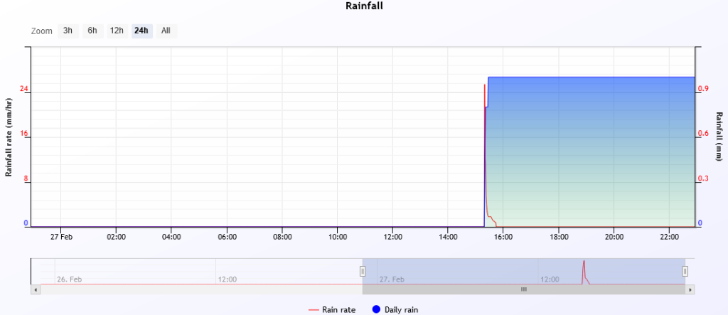   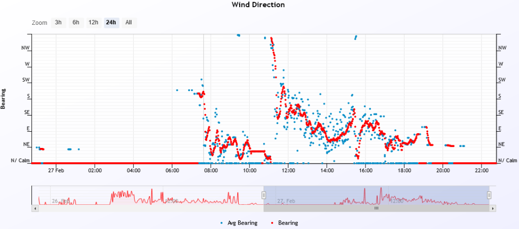 |
|
1 user thanked Falling_Droplet for this useful post.
|
|
|
|
Rank: Advanced Member
Groups: Registered, Administrators Joined: 21/08/2019(UTC) Posts: 941 Location: Brisbane Northside Thanks: 1198 times
Was thanked: 1136 time(s) in 674 post(s)
|
Originally Posted by: Falling_Droplet  A mild and brief thunderstorm at 3:20pm with some moderate falls and a total of 1 mm. The thunderstorm moved in from the south and decayed as it moved through.
] That is a pity Falling Droplet. Looking at yesterday the storms were very much hit and miss but they interacted beautifully closer to the Bayside suburbs and on the Gold Coast. The Northern Bay suburbs fairing the better. Below is the Brisbane Metropolitan Rainfall chart. The city had a very nice cell form and quickly pass over. My wife reported a few rumbles, some rain and it was all over. That was around 14:00 approx. A few cell over the Sunshine Coast, and around the wide bay area. Also included is the Cape chart showing a more Coastal probability as well as the surface wind. I think it was 1300 predicted run that I took a shot off earlier in the morning. A bit of a hectic day yesterday.    Edited by user Friday, 28 February 2020 6:33:19 AM(UTC)
| Reason: Not specified |
Colin Maitland. |
|
|
|
|
|
Rank: Advanced Member
Groups: Registered
Joined: 25/08/2019(UTC) Posts: 1,839 Location: Ferny Grove Thanks: 985 times
Was thanked: 856 time(s) in 419 post(s)
|
Ferny Grove Weather
Date: 28 Feb 2020
Time: 7:55 AM
Min Temp since 9am yesterday: 19.8 C
Max Temp since 9am yesterday: 3.8 C
Min Ground Temp: 19.4 C
Rain since 9am yesterday: 1 mm
Temperature: 24.4 C
Relative Humidity: 85 %
Dew Point: 21.7 C
MSL Pressure: 1007.9 hPa
Wind Speed: 3 kph - light air
Wind Direction: S
Present Weather: State of sky generally unchanged during preceding hour
Visibility: 20km to 39km - Very Good Visibility
Cloud Cover: 1/8
Ground State: Ground moist
Thunder yesterday: Yes
Notes of yesterday weather - 27/2/20: Increasing cu and sc clouds clearing later in the morning becoming mostly cloudy with cu, sc and cb clouds from the middle of the day. A light shower followed a brief and mild decaying storm with some moderate falls in the mid afternoon. The maximum temperature was reached in the middle of the day before falling during the afternoon before stabilising following the storm. The temperature was a little variable in the late morning and the afternoon. The dew point was stable early in the day before slowly rising during the morning and became moderately high and then became stable from the late morning, falling during the afternoon before the storm returning to near average. Following the storm the dew point rose slightly and then slowly fell from 4pm for the remainder of the day. Relative humidity was near average early and during the daytime was variable and moderately high before returning to near average in the evening. Calm winds early in the day, S to SSW in the morning becoming N to ENE and SE to SW in the late morning. In the early afternoon winds were S to SE, ESE to ENE light winds before the storm, SSE to ESE after the storm, SE to NE later in hte afternoon, E to NE in the evening becoming calm later in the evening.
Today: Calm winds with S to SSW winds developing in the last 15 minutes. Moderately high overnight relative humidity. The dew point have been near average while falling before starting to rise this morning.
|
|
1 user thanked Falling_Droplet for this useful post.
|
|
|
|
Rank: Advanced Member
Groups: Registered
Joined: 25/08/2019(UTC) Posts: 1,839 Location: Ferny Grove Thanks: 985 times
Was thanked: 856 time(s) in 419 post(s)
|
|
|
1 user thanked Falling_Droplet for this useful post.
|
|
|
|
Rank: Advanced Member
Groups: Registered
Joined: 25/08/2019(UTC) Posts: 1,839 Location: Ferny Grove Thanks: 985 times
Was thanked: 856 time(s) in 419 post(s)
|
Ferny Grove Weather
Date: 29 Feb 2020
Time: 9:50 AM
Min Temp since 9am yesterday: 22.7 C
Max Temp since 9am yesterday: 33.8 C
Min Ground Temp: 22.7 C
Rain since 9am yesterday: 0.6 mm
Temperature: 21 C
Relative Humidity: 60 %
Dew Point: 18.9 C
MSL Pressure: 1014.2 hPa
Wind Speed: 9 kph - light breeze
Wind Direction: S
Present Weather: Clouds generally forming or developing during the preceding hour
Visibility: 20km to 39km - Very Good Visibility
Cloud Cover: 4/8
Ground State: Ground moist
Thunder yesterday: Yes
Notes of yesterday weather - 28/2/20: Partly cloudy with as, cu and sc clouds before increasing as, cu and cb clouds during the afternoon. A light shower in the mid afternoon and storm passed close by to the west. A warm day with variable temperature in the late morning and in early afternoon. Near average dew point slowly fell early in the day before rising during the morning and became moderately high in the mid morning before returning to near average for the rest of the morning. In the afternoon the dew point was generally near average before slowly rising in the early evening but was a little variable and became stable in the late evening. Relative humidity was near average over the entire day. Calm winds early in the day, S to SW winds during the morning with some SE to NE winds, ESE to ENE in the afternoon, NNE to ENE in the late afternoon, E to SE in the evening which became calm.
Today: A light brief shower at 9:50am. Light SSW to SW winds early today and S to SW in the last few hours. A warm morning with the temperature falling slowly in the early hours. The dew point fell slowly in the early hours before rising a little this morning close to average.
|
|
1 user thanked Falling_Droplet for this useful post.
|
|
|
|
Rank: Advanced Member
Groups: Registered
Joined: 25/08/2019(UTC) Posts: 1,839 Location: Ferny Grove Thanks: 985 times
Was thanked: 856 time(s) in 419 post(s)
|
A midday light brief shower, followed by 2 brief showers at 2pm and 2:25pm. 0.5 mm of rainfall since 9am. The temperature was very variable during the morning and afternoon which rose and fell numerous times. The maximum temperature was near average. The dew point was near average while generally falling during the morning before becoming stable in the middle of the day. In the afternoon the dew point rose while remaining close to average before dropping a little and becoming stable from the mid afternoon. Variable relative humidity during the morning and during the afternoon and was moderately high today before returning to near average tonight. Light S to SW winds during the morning became S to SE from the late morning, SE from 2pm, SW to SSE in the mid afternoon before SSE to ESE for the rest of the afternoon. Earlier tonight winds were SE and have become SSE to SSW since 8pm.
Last 24 hours: 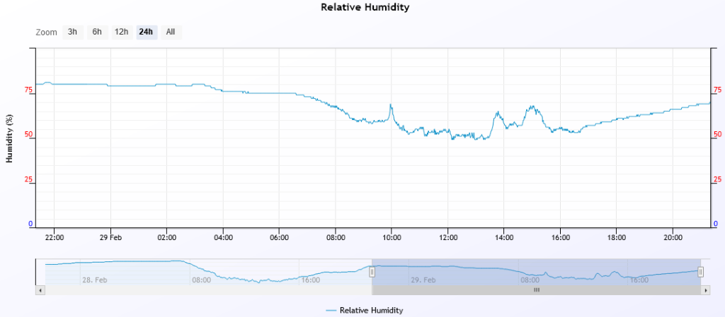  |
|
|
|
|
|
|
Rank: Advanced Member
Groups: Registered
Joined: 25/08/2019(UTC) Posts: 1,839 Location: Ferny Grove Thanks: 985 times
Was thanked: 856 time(s) in 419 post(s)
|
Ferny Grove Weather
Date: 1 Mar 2020
Time: 8:30 AM
Min Temp since 9am yesterday: 19.2 C
Max Temp since 9am yesterday: 30.6 C
Min Ground Temp: 18.2 C
Rain since 9am yesterday: 0.5 mm
Temperature: 26.1 C
Relative Humidity: 64 %
Dew Point: 18.7 C
MSL Pressure: 1014.8 hPa
Wind Speed: 4kph - light breeze
Wind Direction: SW
Present Weather: No cloud development observed
Visibility: 20km to 39km - Very Good Visibility
Cloud Cover: 0/8
Ground State: Ground moist
Notes of yesterday weather - 29/2/20: Partly cloudy with cu and sc clouds. Light showers at 9:50am, midday 2pm and 2:25pm. The dew point fell slowly in the early hours before becoming stable in the middle of the day. In the afternoon the dew point rose close to average, falling a little in the mid afternoon and became near average for the remainder of the day. Near average relative humidity early in the day and in the evening and moderately high during the day and was quite variable. Light SSW to SW in the early hours, S to SW in the morning, shifting to S to SE in the late morning before SE becoming SW to SSE in the mid afternoon and SSE to ESE later in the afternoon. Light SE winds in the early evening, and SSE to SSW from 8pm becoming calm in the late evening.
Today: The dew point slowly fell in the early hours before rising this morning close to average. Moderately high overnight relative humidity and near average this morning. Calm winds have became SSW to SW in the last 30 minutes.
|
|
|
|
|
|
|
Rank: Advanced Member
Groups: Registered
Joined: 25/08/2019(UTC) Posts: 1,839 Location: Ferny Grove Thanks: 985 times
Was thanked: 856 time(s) in 419 post(s)
|
Ferny Grove Summary for February 2020. Very well above average rainfall, warm nights and close to average daytime temperatures 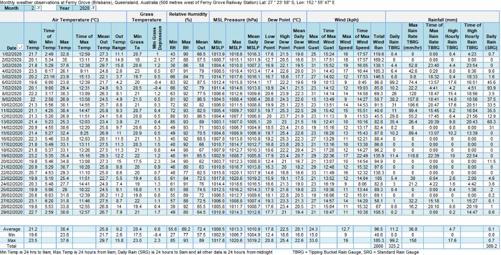  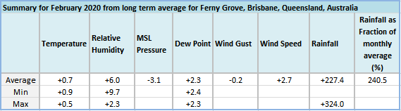 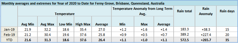 The long period rainfall total for 6 month rainfall is 90 mm above average, 9 monthly rainfall is 30 mm above average and 12 monthly rainfall is 50 mm above average. 18 monthly to 36 monthly rainfall remains very much below average at 90 to 260 mm below average, whilst 48 month rainfall is close to average. The rainfall total for February of 389.2 mm was 140 % above average which is the third highest on record and the highest since 464.8 mm in 1995. For all months of the year this is the highest since 480.7 mm in January 2013. The highest daily rainfall total of 90.9 mm on the 9th was the highest February daily rainfall total since 143.4 mm on the 24st in 2018. For any month it was also the highest since 143.4 mm on 24 February 2018. The longest period of consecutive days of rainfall was 11 days which compared with previous February wet spells and equal highest since 284.4 mm in 11 days between the 11th and 25th in 2015. That was the second highest on record, whereas the longest February wet spell is 14 days between 31 January and 7 February 2003 (99.5 mm). When compared with previous wet spells across all months there were 24 other previous periods of greater than 11 days with the highest being 62 days between 28 March and 9 April 2011 (70.5 mm). For wet spell total this event was significant compared to previous wet spells rainfall totals and was the highest for February (previously 284.4 mm between 14 February 2015 and 25 February 2015). For any month this was the highest since 459 mm between the 23 January and 29 January 2013. The year to date total of 572.5 mm (265.7 mm above average and 86.6 % above average) when compared with previous January to February totals is the highest since 711.9 mm in 2013. Edited by user Sunday, 1 March 2020 11:35:01 PM(UTC)
| Reason: Not specified |
|
|
|
|
|
|
Rank: Advanced Member
Groups: Registered
Joined: 25/08/2019(UTC) Posts: 1,839 Location: Ferny Grove Thanks: 985 times
Was thanked: 856 time(s) in 419 post(s)
|
A warm day with variable temperature in the late morning and early afternoon. The dew point continued to rise until the mid morning close to average before falling for the rest of the morning and in the early afternoon. While remaining close to average the dew point rose in the early afternoon before very slowly rising in the afternoon and very slowly falling tonight. Relative humidity have been near average today and also tonight. Light S to SW winds during the morning with also ESE to S from the mid morning followed by SE to NE winds with some N to NE in the early afternoon. After this was E to NE light winds before becoming calm at times later tonight. Last 24 hours:   Edited by user Sunday, 1 March 2020 11:39:24 PM(UTC)
| Reason: Not specified |
|
|
|
|
|
|
Rank: Advanced Member
Groups: Registered
Joined: 25/08/2019(UTC) Posts: 1,839 Location: Ferny Grove Thanks: 985 times
Was thanked: 856 time(s) in 419 post(s)
|
Ferny Grove Weather
Date: 2 Mar 2020
Time: 7:50 AM
Min Temp since 9am yesterday: 19.6 C
Max Temp since 9am yesterday: 32.2 C
Min Ground Temp: 18 C
Rain since 9am yesterday: Trace (Dew)
Temperature: 23.4 C
Relative Humidity: 76 %
Dew Point: 19 C
MSL Pressure: 1014 hPa
Wind Speed: Calm
Wind Direction: Calm
Present Weather: No cloud development observed
Visibility: 20km to 39km - Very Good Visibility
Cloud Cover: 0/8
Ground State: Ground moist
Notes of yesterday weather - 1/3/20: Mostly sunny with cu and sc clouds. The temperature was a little variable in the late morning and early afternoon. In the early hours the dew point slowly fell, rose during the morning until the mid morning before falling from the mid morning and was close to average. The dew point rose during the early afternoon before very slowly rising during the rest of the afternoon and then slowly fell during the evening while remaining close to average. Moderately high relative humidity early in the day before near average relative humidity for the rest of the day. Calm winds early in the day, light SSW to SW developed in the morning, ESE to S from the mid morning, SE to NE winds with some N to NE winds in the early afternoon, before E to NE winds and calm later in the evening.
Today: Calm winds early today before in the last 30 minutes was light N through to W becoming W to SW. Relative humidity have been moderately high so far today. The dew point have been near average and stable in the early hours of today before stating to rise this morning.
|
|
|
|
|
|
|
Rank: Advanced Member
Groups: Registered
Joined: 25/08/2019(UTC) Posts: 1,839 Location: Ferny Grove Thanks: 985 times
Was thanked: 856 time(s) in 419 post(s)
|
|
|
|
|
|
|
|
Weather Forum
»
Australia Weather
»
SEQ and NE NSW
»
SE QLD and NE NSW - Day to Day Weather
Forum Jump
You cannot post new topics in this forum.
You cannot reply to topics in this forum.
You cannot delete your posts in this forum.
You cannot edit your posts in this forum.
You cannot create polls in this forum.
You cannot vote in polls in this forum.
Important Information:
The Weather Forum uses cookies. By continuing to browse this site, you are agreeing to our use of cookies.
More Details
Close
