Weather Forum

Welcome Guest! To enable all features please Login or Register.

Notification

Icon
Error

10 Pages<1234>»
Share
Options
Go to last post Go to first unread
Offline crikey  
#21 Posted : Thursday, 26 September 2019 4:14:04 PM(UTC)
crikey

Rank: Advanced Member

Groups: Registered
Joined: 24/08/2019(UTC)
Posts: 292
Australia
Location: Country Victorian

Thanks: 580 times
Was thanked: 503 time(s) in 194 post(s)
Originally Posted by: i4hanish Go to Quoted Post
I am quite impressed with the lifted index forecast by GFS (bsch stormcast)

The current activity is exactly where it was forecast to be .Charleville ,Roma way

Might have a look at tomorrows a bit later on.


Yes. Forecast panning out. I noticed GFS rain forecast on BCSH captured the rain band in NE NSW very well.

Casino has had 5mm . Much needed there. Looks like Coffs Harbour might be about to get a storm.

I am wondering if that NW/SE band will make it over the ranges to the Tweed. Just had a look out the back and no sign of darkening cloud here so not expecting much at all. But l would like to here the pitter patter on the roof.

thanks 5 users thanked crikey for this useful post.
i4hanish on 26/09/2019(UTC), oceangyre on 26/09/2019(UTC), juztchillin on 26/09/2019(UTC), Falling_Droplet on 26/09/2019(UTC), Colmait on 27/09/2019(UTC)
Offline Ken  
#22 Posted : Thursday, 26 September 2019 4:25:41 PM(UTC)
Ken

Rank: Advanced Member

Groups: Registered
Joined: 2/09/2019(UTC)
Posts: 105
Australia
Location: Brisbane

Thanks: 145 times
Was thanked: 561 time(s) in 103 post(s)
Originally Posted by: crikey Go to Quoted Post
Originally Posted by: i4hanish Go to Quoted Post
I am quite impressed with the lifted index forecast by GFS (bsch stormcast)

The current activity is exactly where it was forecast to be .Charleville ,Roma way

Might have a look at tomorrows a bit later on.


Yes. Forecast panning out. I noticed GFS rain forecast on BCSH captured the rain band in NE NSW very well.

Casino has had 5mm . Much needed there. Looks like Coffs Harbour might be about to get a storm.

I am wondering if that NW/SE band will make it over the ranges to the Tweed. Just had a look out the back and no sign of darkening cloud here so not expecting much at all. But l would like to here the pitter patter on the roof.


The often reliable ACCESS-C has been suggesting southern and western parts of our region (as far as SE QLD goes) are favoured for any activity compared to other parts of the region - if any of it does manage to reach the coast in SE QLD (which isn't a certainty yet), it'll probably be later tonight, also reflected in the soundings.

ACCESS-C from 10am today til midnight tonight via Weatherzone - as you can see, it's been pretty close to the mark so far as per usual: https://www.youtube.com/watch?v=...kZU&feature=youtu.be

Edited by user Thursday, 26 September 2019 4:29:45 PM(UTC)  | Reason: Not specified

thanks 8 users thanked Ken for this useful post.
crikey on 26/09/2019(UTC), Paul Atkins on 26/09/2019(UTC), DelBoy on 26/09/2019(UTC), i4hanish on 26/09/2019(UTC), oceangyre on 26/09/2019(UTC), juztchillin on 26/09/2019(UTC), Falling_Droplet on 26/09/2019(UTC), Colmait on 27/09/2019(UTC)
Offline crikey  
#23 Posted : Thursday, 26 September 2019 4:44:04 PM(UTC)
crikey

Rank: Advanced Member

Groups: Registered
Joined: 24/08/2019(UTC)
Posts: 292
Australia
Location: Country Victorian

Thanks: 580 times
Was thanked: 503 time(s) in 194 post(s)
You tube forecast time lapse. I like that.BigGrin Thanks Ken.

I am comparing ACC r 1-4pm today , with the same period of time tomorrow and tomorrow looks much stronger regarding precip' signal.BigGrin

I will post a few snaps later of ACC r forecast and delve a bit deeper . Lovely to have at least some activity on the weather front.

Current radar


26th sept 2019 SEQ rainband.jpg
thanks 6 users thanked crikey for this useful post.
Ken on 26/09/2019(UTC), i4hanish on 26/09/2019(UTC), oceangyre on 26/09/2019(UTC), juztchillin on 26/09/2019(UTC), Falling_Droplet on 26/09/2019(UTC), Colmait on 27/09/2019(UTC)
Offline DelBoy  
#24 Posted : Thursday, 26 September 2019 6:00:16 PM(UTC)
DelBoy

Rank: Advanced Member

Groups: Registered
Joined: 13/09/2019(UTC)
Posts: 118
Location: Caboolture (the next Las Vegas!)

Thanks: 215 times
Was thanked: 297 time(s) in 100 post(s)
Love it. A time lapse of ACCESS-C for us all to see. Good stuff.
The resolution and detail of the isobars is pretty impressive.
thanks 7 users thanked DelBoy for this useful post.
Ken on 26/09/2019(UTC), crikey on 26/09/2019(UTC), i4hanish on 26/09/2019(UTC), oceangyre on 26/09/2019(UTC), juztchillin on 26/09/2019(UTC), Falling_Droplet on 26/09/2019(UTC), Colmait on 27/09/2019(UTC)
Offline CantSpellNarangba  
#25 Posted : Thursday, 26 September 2019 6:04:17 PM(UTC)
CantSpellNarangba

Rank: Advanced Member

Groups: Registered
Joined: 23/08/2019(UTC)
Posts: 155
Australia
Location: Narangba

Thanks: 280 times
Was thanked: 442 time(s) in 136 post(s)
WATL currently has mostly small traces of rain on Saturday for this area.

PMEPROB_aus.png

Great to see inland rain today and tomorrow.

Edited by user Thursday, 26 September 2019 6:05:52 PM(UTC)  | Reason: Not specified

thanks 7 users thanked CantSpellNarangba for this useful post.
Ken on 26/09/2019(UTC), crikey on 26/09/2019(UTC), i4hanish on 26/09/2019(UTC), oceangyre on 26/09/2019(UTC), juztchillin on 26/09/2019(UTC), Falling_Droplet on 26/09/2019(UTC), Colmait on 27/09/2019(UTC)
Offline crikey  
#26 Posted : Thursday, 26 September 2019 6:07:18 PM(UTC)
crikey

Rank: Advanced Member

Groups: Registered
Joined: 24/08/2019(UTC)
Posts: 292
Australia
Location: Country Victorian

Thanks: 580 times
Was thanked: 503 time(s) in 194 post(s)
The sky has darkened here SW and SE of the Tweed. Looking at radar that rain band looks to be heading toward us with some

development. Thats a nice surprise.Very still and eerie here .


Here is tomorrows ACC r. This is the 4pm slot showing the highest precip'signal strength.

The signal starts at 1pm and lasts until tea time . The position is favoring SE QLD tomorrow.

Hopefully some drips at least. For any parched areas


Saturday the precip signal is around Sunshine coast to mid coast latitude.
edit ( There must be some model divergence because ACC r puts that rain signal on saturday further north?)

Sunday and Monday more coastal.


27th sept 2019 rain SEQ.jpg
source
http://www.bom.gov.au/au...harts/viewer/index.shtml

Edited by user Thursday, 26 September 2019 6:11:20 PM(UTC)  | Reason: Not specified

thanks 5 users thanked crikey for this useful post.
i4hanish on 26/09/2019(UTC), oceangyre on 26/09/2019(UTC), juztchillin on 26/09/2019(UTC), Falling_Droplet on 26/09/2019(UTC), Colmait on 27/09/2019(UTC)
Offline Skeetpete  
#27 Posted : Thursday, 26 September 2019 6:36:15 PM(UTC)
Skeetpete

Rank: Advanced Member

Groups: Registered
Joined: 21/08/2019(UTC)
Posts: 35
Australia
Location: Toowoomba

Thanks: 29 times
Was thanked: 120 time(s) in 33 post(s)
Crikey it looks like you might pick up a few mils later.Nice line moving E/NE towards the coast
Casino has picked up 9mils.Glad some other people will get a little as well.
thanks 6 users thanked Skeetpete for this useful post.
DelBoy on 26/09/2019(UTC), oceangyre on 26/09/2019(UTC), juztchillin on 26/09/2019(UTC), Falling_Droplet on 26/09/2019(UTC), Colmait on 27/09/2019(UTC), crikey on 27/09/2019(UTC)
Offline i4hanish  
#28 Posted : Thursday, 26 September 2019 6:46:38 PM(UTC)
i4hanish

Rank: Advanced Member

Groups: Registered
Joined: 15/09/2019(UTC)
Posts: 39
Australia
Location: Forster NSW mid coast

Thanks: 172 times
Was thanked: 135 time(s) in 39 post(s)
Ok. I have had a look at the Lifted index LI for tomorrow afternoon in QLD. There is pretty much nothing there.

So l had a look at the CAPE and it looks like the same as the ACC r model forecast.

So l guess l have a question. Why is LI zilch but CAPE wide spread??Confused

The link
Select 1pm

http://stormcast.com.au/...92703:aus:cape:null:0#sc

The rain signal from GFS bcsh stormcast is weak in the afternoon but much stronger near Brisbane around 7pm

Different model output.

26th sept 19 SEQ cape.jpg
thanks 5 users thanked i4hanish for this useful post.
DelBoy on 26/09/2019(UTC), oceangyre on 26/09/2019(UTC), juztchillin on 26/09/2019(UTC), Falling_Droplet on 26/09/2019(UTC), crikey on 27/09/2019(UTC)
Offline Ken  
#29 Posted : Thursday, 26 September 2019 6:57:23 PM(UTC)
Ken

Rank: Advanced Member

Groups: Registered
Joined: 2/09/2019(UTC)
Posts: 105
Australia
Location: Brisbane

Thanks: 145 times
Was thanked: 561 time(s) in 103 post(s)
Originally Posted by: i4hanish Go to Quoted Post
Ok. I have had a look at the Lifted index LI for tomorrow afternoon in QLD. There is pretty much nothing there.

So l had a look at the CAPE and it looks like the same as the ACC r model forecast.

So l guess l have a question. Why is LI zilch but CAPE wide spread??Confused

The link
Select 1pm

http://stormcast.com.au/...92703:aus:cape:null:0#sc

The rain signal from GFS bcsh stormcast is weak in the afternoon but much stronger near Brisbane around 7pm

Different model output.

LI's only nominally measure the temp difference between rising parcels of air and the environmental air at a single fixed height (typically 500hpa), whereas CAPE uses the height range of the vertical profile of the atmosphere over a given point where rising air parcels are warmer than the surrounding air.
So for example, if a rising parcel of air stays warmer than the surrounding air from when it condenses into cloud at say the 850hpa height right up to 300hpa, there's positive CAPE all the way from 850hpa up to 300hpa, and the amount of CAPE will depend on how much warmer that parcel will be than the surrounding air through that height range i.e. it's an integral.
thanks 9 users thanked Ken for this useful post.
Paul Atkins on 26/09/2019(UTC), DelBoy on 26/09/2019(UTC), i4hanish on 26/09/2019(UTC), oceangyre on 26/09/2019(UTC), juztchillin on 26/09/2019(UTC), Falling_Droplet on 26/09/2019(UTC), Colmait on 27/09/2019(UTC), Skeetpete on 27/09/2019(UTC), crikey on 27/09/2019(UTC)
Offline i4hanish  
#30 Posted : Thursday, 26 September 2019 7:18:42 PM(UTC)
i4hanish

Rank: Advanced Member

Groups: Registered
Joined: 15/09/2019(UTC)
Posts: 39
Australia
Location: Forster NSW mid coast

Thanks: 172 times
Was thanked: 135 time(s) in 39 post(s)
Originally Posted by: Ken Go to Quoted Post
Originally Posted by: i4hanish Go to Quoted Post
Ok. I have had a look at the Lifted index LI for tomorrow afternoon in QLD. There is pretty much nothing there.

So l had a look at the CAPE and it looks like the same as the ACC r model forecast.

So l guess l have a question. Why is LI zilch but CAPE wide spread??Confused

The link
Select 1pm

http://stormcast.com.au/...92703:aus:cape:null:0#sc

The rain signal from GFS bcsh stormcast is weak in the afternoon but much stronger near Brisbane around 7pm

Different model output.

LI's only nominally measure the temp difference between rising parcels of air and the environmental air at a single fixed height (typically 500hpa), whereas CAPE uses the height range of the vertical profile of the atmosphere over a given point where rising air parcels are warmer than the surrounding air.
So for example, if a rising parcel of air stays warmer than the surrounding air from when it condenses into cloud at say the 850hpa height right up to 300hpa, there's positive CAPE all the way from 850hpa up to 300hpa, and the amount of CAPE will depend on how much warmer that parcel will be than the surrounding air through that height range i.e. it's an integral.


I do have trouble Ken . I really am a beginner here. With storm dynamics. I understand that CAPE gives a better representation of

severe storm potential than LI ?

I did some homework. CAPE means Convective available potential energy.

So the highest CAPE tomorrow afternoon is over the Hinterlands near Murwillumbah way at around 300 joules/kg.

So does that mean severe storms are more likely at 300 j/kg

thanks 4 users thanked i4hanish for this useful post.
oceangyre on 26/09/2019(UTC), juztchillin on 26/09/2019(UTC), Falling_Droplet on 26/09/2019(UTC), crikey on 27/09/2019(UTC)
Offline i4hanish  
#31 Posted : Thursday, 26 September 2019 7:33:17 PM(UTC)
i4hanish

Rank: Advanced Member

Groups: Registered
Joined: 15/09/2019(UTC)
Posts: 39
Australia
Location: Forster NSW mid coast

Thanks: 172 times
Was thanked: 135 time(s) in 39 post(s)

I will post this GFS (bcsh stormcast) rain forecast for tomorrow evening around 7pm. The model is giving some lucky sole a possible maximum of 19mm out west of Brisbane way

I would like to see how this forecast plays out.

BTW. The storm line is still active out in central QLD
https://www.lightningmap...ceania/index.php?lang=en


27th sept 19 rain forecast GFS stormcast.jpg


thanks 6 users thanked i4hanish for this useful post.
oceangyre on 26/09/2019(UTC), DelBoy on 26/09/2019(UTC), juztchillin on 26/09/2019(UTC), Falling_Droplet on 26/09/2019(UTC), Colmait on 27/09/2019(UTC), crikey on 27/09/2019(UTC)
Offline oceangyre  
#32 Posted : Thursday, 26 September 2019 7:47:45 PM(UTC)
oceangyre

Rank: Advanced Member

Groups: Registered
Joined: 3/09/2019(UTC)
Posts: 51
Australia
Location: gladstone

Thanks: 108 times
Was thanked: 50 time(s) in 26 post(s)
There has been some rain in the QLD interior under that cloud today. I won't list the towns.
Not only can l not pronounce them but it would take a long time to spell them

So here is the graphic

A few of those dark blue dots had 10mm

26th sept 19 qld interior rain.jpg

thanks 4 users thanked oceangyre for this useful post.
DelBoy on 26/09/2019(UTC), juztchillin on 26/09/2019(UTC), Falling_Droplet on 26/09/2019(UTC), crikey on 27/09/2019(UTC)
Offline DelBoy  
#33 Posted : Thursday, 26 September 2019 7:56:58 PM(UTC)
DelBoy

Rank: Advanced Member

Groups: Registered
Joined: 13/09/2019(UTC)
Posts: 118
Location: Caboolture (the next Las Vegas!)

Thanks: 215 times
Was thanked: 297 time(s) in 100 post(s)
So great to see the inland parts getting some well needed rain. ThumpUp
thanks 5 users thanked DelBoy for this useful post.
oceangyre on 26/09/2019(UTC), juztchillin on 26/09/2019(UTC), Falling_Droplet on 26/09/2019(UTC), crikey on 27/09/2019(UTC), Colmait on 27/09/2019(UTC)
Offline juztchillin  
#34 Posted : Thursday, 26 September 2019 8:14:53 PM(UTC)
juztchillin

Rank: Advanced Member

Groups: Registered
Joined: 21/09/2019(UTC)
Posts: 32
Australia
Location: Gold coast

Thanks: 125 times
Was thanked: 126 time(s) in 31 post(s)


8pm.Its raining on rhe Gold coast. Aaaaahhhhh. The sound and smell is glorious Dancing


26th sept 19 rain NE NSW.jpg
thanks 4 users thanked juztchillin for this useful post.
Falling_Droplet on 26/09/2019(UTC), CharlieBrown on 27/09/2019(UTC), crikey on 27/09/2019(UTC), Colmait on 27/09/2019(UTC)
Offline Falling_Droplet  
#35 Posted : Thursday, 26 September 2019 9:55:05 PM(UTC)
Falling_Droplet

Rank: Advanced Member

Groups: Registered
Joined: 25/08/2019(UTC)
Posts: 1,839
Australia
Location: Ferny Grove

Thanks: 985 times
Was thanked: 856 time(s) in 419 post(s)
Cloudy conditions caused the temperature to be quite variable. Since 8pm the temperature have been stable Near average dew point and relative humidity today. Relative humidity have been stable for the last hour. Light E to NE winds and have been N to NE since 8pm. I will see in the morning if I managed to measure any rain out of some light drizzle in the last hour. Not enough received to register on weather station.

Last 24 hours:


temp 2019-09-26.PNGhum 2019-09-26.PNG

Edited by user Thursday, 26 September 2019 9:55:40 PM(UTC)  | Reason: Not specified

thanks 2 users thanked Falling_Droplet for this useful post.
crikey on 27/09/2019(UTC), Colmait on 27/09/2019(UTC)
Offline Colmait  
#36 Posted : Friday, 27 September 2019 6:48:38 AM(UTC)
Colmait

Rank: Advanced Member

Groups: Registered
Joined: 21/08/2019(UTC)
Posts: 488
Australia
Location: Brisbane Northside

Thanks: 1036 times
Was thanked: 686 time(s) in 241 post(s)
Originally Posted by: i4hanish Go to Quoted Post

I will post this GFS (bcsh stormcast) rain forecast for tomorrow evening around 7pm. The model is giving some lucky sole a possible maximum of 19mm out west of Brisbane way

I would like to see how this forecast plays out.

BTW. The storm line is still active out in central QLD
https://www.lightningmap...ceania/index.php?lang=en


27th sept 19 rain forecast GFS stormcast.jpg


This is where the soundings come into play. LI,s and Cape are only 2 ingredients. You can have LI’s of -5 and have blue skies. You can have LI’s of -1 and you could have a tornado.

The sounding is a view of the atmosphere, usually, if the balloon makes it which 99% of the time it does, we get to see what is happening way past past 30000 feet. The only problem with a sounding is, for example, it is released at the Brisbane airport so it does not cover a very large area. The sonde attached to the balloon reads all the vital info and then it is analysed and put into the form of the sounding. There we get the temperature, dew points, moisture levels cape,cap,CIN TotalTotals etc.etc
I am still trying to piece that all together and place that into the general weather thread for storms.

So the storm cast for Friday 7:00pm has pretty well fallen flat with the latest run. We could maybe get a shower here and there.

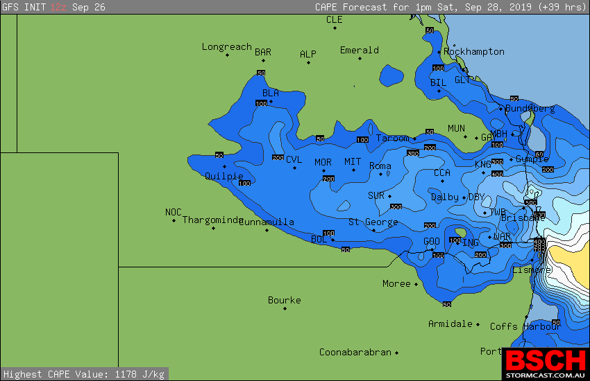
But for Saturday things have picked up a little bit on the positive side for a chance of storms if everything comes together. So I have used the 13:00 (1:00pm) here.

Figure 1 is the LI’s, they are not through the roof as in negative values but that doesn’t really matter, on a good storm day if they ever happen again Angry BigGrin we will see readings of -5, -6, -7 etc.
BFD8C7D7-3773-4188-B2EE-F94799324B51.png

Second figure is the cape. Once again not high values in the cape but still there is a chance
Figure 2.
26EEC8F5-2CF4-48BD-8CF3-0EEB1129DC3B.png

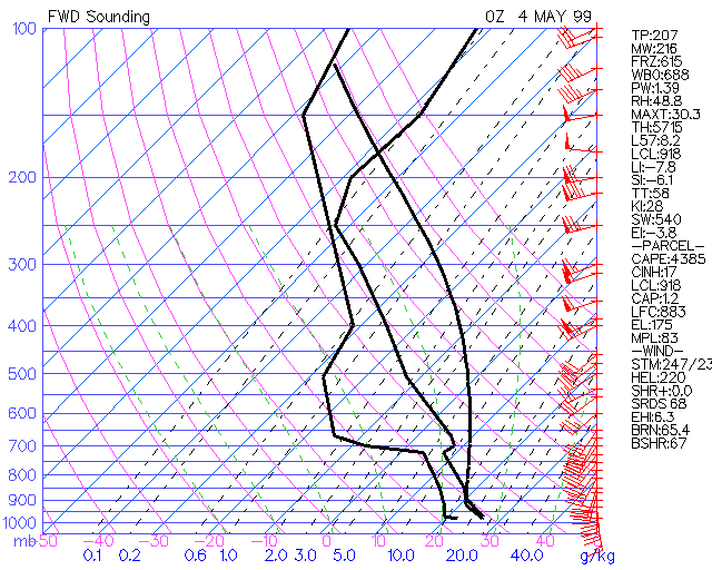
Now the forecast sounding gives us a slice of the atmosphere, but this one is only a forecast sounding, on Saturday we really want to see the Soundings at 11:00. Most of us will look at Brisbane and other areas. Just on a side note, Moree doesn’t seem to have sounding lately, unless I have just been unlucky

Figure 3.

4682B9E7-9F72-456C-B423-C205AB98A79F.png

As you can see the LIs are -1.18. The cape is low at 207 j/kg. The cap is very low at 0.2°C. There is some moisture between 825mb and 700 mb.
There is a bit of instability by looking at the grey line. A small inversion at 650 mb but it doesn’t affect the cape or instability. Edit forgot the Total Totals is 52.8 which is isolated possible severe storms. It is close to 53 which is widely scattered possible severe storms. So we “could” see maybe a severe storm if everything pulls together. It is not the hard rule but a guideline with the chart used.
The sheers is good. All we need is small a trigger and they should fire off easily if everything comes together.

So going of this forecast sounding there is a possible chance of a storm around Brisbane and surrounding areas of SEQ tomorrow afternoon. Not over the top, but a possible chance. Some places maybe severe.

This figure of a sounding would have me running like mad. This is a full on storm so you will see the difference. It is called the loaded gun.
21E53C4E-87BB-48FF-89A8-445AF684F71E.gif

Edited by user Friday, 27 September 2019 8:54:28 AM(UTC)  | Reason: Speilinking and proof reading and changing what I wrote, ipad are too small to see everything.

Colin Maitland.
thanks 4 users thanked Colmait for this useful post.
Pabloako on 27/09/2019(UTC), crikey on 27/09/2019(UTC), Falling_Droplet on 27/09/2019(UTC), Mama Tus on 28/09/2019(UTC)
Offline crikey  
#37 Posted : Friday, 27 September 2019 8:39:26 AM(UTC)
crikey

Rank: Advanced Member

Groups: Registered
Joined: 24/08/2019(UTC)
Posts: 292
Australia
Location: Country Victorian

Thanks: 580 times
Was thanked: 503 time(s) in 194 post(s)
Colin..... Thankyou so much for your time and effort . I am following along with interest. Very informative post BigGrin

ACC r still looking ok today with a weak to moderate precip' signal.,The signal appears around 1pm again.

It goes through to about tea time

I will say ACC r is good at picking up the afternoon activity but sometimes fails to see the activity going on in to the evening
or moving on to the coast.

I don't know whats up with WATL its hasn't been picking up the higher totals.Forecasting only a mm .,The final totals see a better result.

The band looked promising 'pete' but didn't deliver much . Which surprised me.Here at Tweed heads only 2mm Overnight .


26th sept rain QLD.jpg
thanks 5 users thanked crikey for this useful post.
Skeetpete on 27/09/2019(UTC), Colmait on 27/09/2019(UTC), Ken on 27/09/2019(UTC), Falling_Droplet on 27/09/2019(UTC), Mama Tus on 28/09/2019(UTC)
Offline Pabloako  
#38 Posted : Friday, 27 September 2019 8:42:08 AM(UTC)
Pabloako

Rank: Advanced Member

Groups: Registered
Joined: 21/08/2019(UTC)
Posts: 185
Australia
Location: Ocean View

Thanks: 359 times
Was thanked: 539 time(s) in 161 post(s)
Great stuff Colin! Thank you. ThumpUp
Also wonderful to see that some inland locations had some rain overnight too. Sadly missed out here, but hopefully over the next day or so we will get a sprinkle.
thanks 4 users thanked Pabloako for this useful post.
Colmait on 27/09/2019(UTC), Ken on 27/09/2019(UTC), Falling_Droplet on 27/09/2019(UTC), crikey on 27/09/2019(UTC)
Offline Ken  
#39 Posted : Friday, 27 September 2019 8:53:52 AM(UTC)
Ken

Rank: Advanced Member

Groups: Registered
Joined: 2/09/2019(UTC)
Posts: 105
Australia
Location: Brisbane

Thanks: 145 times
Was thanked: 561 time(s) in 103 post(s)
Originally Posted by: crikey Go to Quoted Post
[b]I don't know whats up with WATL its hasn't been picking up the higher totals.Forecasting only a mm .,The final totals see a better result.

The band looked promising 'pete' but didn't deliver much . Which surprised me.Here at Tweed heads only 2mm Overnight .


Just remember, WATL's rainfall amount maps are an average of 8 models (whose rainfall positioning is then adjusted to account for differing positions of heavier rainfall)so if some of the component models are hardly forecasting any rain, it'll push that average down. Also note that WATL maps won't show any forecast amounts below 1mm because that's the min threshold for the colour scale.
Also worth remembering that the exact rainfall amounts and positioning from patchy convective rainfall are much harder to accurately predict than widespread stratiform rainfall with some locations getting a lot less or more than others. So using a multimodel average will blur these finer details (but this type of consensus approach is statistically more accurate on average than using a single model).

Also, those bands of showers/storms will often look more impressive on radar than the rainfall amounts they produce during dry regimes such as the current one because the constant height of about 10,000ft that the radar scans for the public radar imagery means that a significant proportion of that rainfall evaporates before reaching the ground.
thanks 4 users thanked Ken for this useful post.
Colmait on 27/09/2019(UTC), Falling_Droplet on 27/09/2019(UTC), crikey on 27/09/2019(UTC), Mama Tus on 28/09/2019(UTC)
Offline crikey  
#40 Posted : Friday, 27 September 2019 9:11:47 AM(UTC)
crikey

Rank: Advanced Member

Groups: Registered
Joined: 24/08/2019(UTC)
Posts: 292
Australia
Location: Country Victorian

Thanks: 580 times
Was thanked: 503 time(s) in 194 post(s)
Originally Posted by: Ken Go to Quoted Post
Originally Posted by: crikey Go to Quoted Post
[b]I don't know whats up with WATL its hasn't been picking up the higher totals.Forecasting only a mm .,The final totals see a better result.

The band looked promising 'pete' but didn't deliver much . Which surprised me.Here at Tweed heads only 2mm Overnight .


Just remember, WATL's rainfall amount maps are an average of 8 models (whose rainfall positioning is then adjusted to account for differing positions of heavier rainfall)so if some of the component models are hardly forecasting any rain, it'll push that average down. Also note that WATL maps won't show any forecast amounts below 1mm because that's the min threshold for the colour scale.
Also worth remembering that the exact rainfall amounts and positioning from patchy convective rainfall are much harder to accurately predict than widespread stratiform rainfall with some locations getting a lot less or more than others. So using a multimodel average will blur these finer details (but this type of consensus approach is statistically more accurate on average than using a single model).

Also, those bands of showers/storms will often look more impressive on radar than the rainfall amounts they produce during dry regimes such as the current one because the constant height of about 10,000ft that the radar scans for the public radar imagery means that a significant proportion of that rainfall evaporates before reaching the ground.


Yes.Thanks for that KEN. Makes sense. If l think back ACC R was only showing very light totals . I forget that models don't show thunderstorm out put and that is why we always say. 'could be higher totals under thunderstorms'Blushing
Also forgetting that the tweed is on the other side of the ranges and we sometimes get less with the weaker systems and the ranges get more.


I have seen WATL do very well indeed with some of those big depressions.

Anyway great to have something to watch and cheer for. Good luck today 'guys' with any amount of rain and stormsThumpUp

Edited by user Friday, 27 September 2019 9:14:21 AM(UTC)  | Reason: Not specified

thanks 4 users thanked crikey for this useful post.
Ken on 27/09/2019(UTC), Colmait on 27/09/2019(UTC), Paul Atkins on 27/09/2019(UTC), Mama Tus on 28/09/2019(UTC)
Users browsing this topic
UnknownOceanSpiders 0.0
10 Pages<1234>»
Forum Jump  
You cannot post new topics in this forum.
You cannot reply to topics in this forum.
You cannot delete your posts in this forum.
You cannot edit your posts in this forum.
You cannot create polls in this forum.
You cannot vote in polls in this forum.

Weather Forum

Weatherzone Forum Alternative

The Weather Forum for Australia

Australian Weather Forum

Weather Forum for Australia, climate change, storm chasing, cyclones, weather photography