Weather Forum

Welcome Guest! To enable all features please Login or Register.

Notification

Icon
Error

Share
Options
Go to last post Go to first unread
Offline Paul Atkins  
#1 Posted : Wednesday, 21 August 2019 7:59:00 AM(UTC)
Paul Atkins

Rank: Administration

Groups: Administrators
Joined: 9/08/2019(UTC)
Posts: 70

Thanks: 151 times
Was thanked: 97 time(s) in 40 post(s)
Time is ticking and the Coral Sea 2019/2020 Cyclone Season is on its way. A Weather Forum to discuss what will happen this season?hat will happen this season?

Edited by user Tuesday, 10 September 2019 1:18:02 PM(UTC)  | Reason: Not specified

Offline crikey  
#2 Posted : Tuesday, 24 September 2019 1:07:43 PM(UTC)
crikey

Rank: Advanced Member

Groups: Registered
Joined: 24/08/2019(UTC)
Posts: 292
Australia
Location: Country Victorian

Thanks: 580 times
Was thanked: 503 time(s) in 194 post(s)
I have been monitoring cross equatorial wind stream flow since early September this year (2019).
I am happy to say 2 major windstreams are making their way toward and even across the equator this week
There is even a flicker of the monsoon trough emerging in the mid pacific atm.

A massive area of low pressure in the Nth pacific currently .,With high humidity and high convection.

I am not making any claims the monsoon will be early. I am just making some early observations.

There are some very strong easterly winds across the 10deg latitude line currently
cheers


cross equatorial flow 23rd sept 2019
source
https://weathercycles.wo.../cross-equatorial-winds/
thanks 4 users thanked crikey for this useful post.
junglegal on 24/09/2019(UTC), Colmait on 24/09/2019(UTC), oceangyre on 25/09/2019(UTC), i4hanish on 25/09/2019(UTC)
Offline CantSpellNarangba  
#3 Posted : Tuesday, 24 September 2019 8:04:24 PM(UTC)
CantSpellNarangba

Rank: Advanced Member

Groups: Registered
Joined: 23/08/2019(UTC)
Posts: 155
Australia
Location: Narangba

Thanks: 280 times
Was thanked: 442 time(s) in 136 post(s)
Good stuff. Very interesting.
thanks 1 user thanked CantSpellNarangba for this useful post.
Colmait on 24/09/2019(UTC)
Offline crikey  
#4 Posted : Monday, 7 October 2019 8:33:15 AM(UTC)
crikey

Rank: Advanced Member

Groups: Registered
Joined: 24/08/2019(UTC)
Posts: 292
Australia
Location: Country Victorian

Thanks: 580 times
Was thanked: 503 time(s) in 194 post(s)
7th oct 2019

cross equatorial not evident here. Not unusual .( Just an observation)
The low pressure in the NH pacific is currently wrapping up any cross equatorial potential.
Strong easterly flow across the SH equatorial


6thoct19 cross equatorial flow.jpg
thanks 1 user thanked crikey for this useful post.
CuNimJim on 21/10/2019(UTC)
Offline 28degrees  
#5 Posted : Saturday, 14 March 2020 8:50:38 PM(UTC)
28degrees

Rank: Advanced Member

Groups: Registered
Joined: 27/08/2019(UTC)
Posts: 870
Australia
Location: Chillagoe

Thanks: 1354 times
Was thanked: 405 time(s) in 286 post(s)
Soon to be "Gretel" has finally got a bit of shape.
https://earth.nullschool...phic=-214.19,-16.10,1106

2020-03-14 204840 EarthWind to be Gretel.jpg

http://www.bom.gov.au/products/IDQ65002.shtml
TROPICAL CYCLONE FORECAST TRACK MAP
Tropical Low
Issued at 5:05 pm AEST Saturday 14 March 2020. No Tropical Cyclone Advice is current for this system.

20200314 1705 TL CapeYork track.jpg


Headline:

Tropical cyclone expected to develop tonight and move further away from Queensland. The system is likely to impact Norfolk Island on Monday.

Areas affected:

Warning zone: None.

Watch zone: Norfolk Island.

Cancelled zones: None.

Details of Tropical Low at 4:00 pm AEST:

Intensity: tropical low, sustained winds near the centre of 55 kilometres per hour with wind gusts to 85 kilometres per hour.
Location: within 55 kilometres of 17.2 degrees South, 155.5 degrees East , 1830 kilometres northwest of Norfolk Island and 800 kilometres east northeast of Mackay .
Movement: east southeast at 23 kilometres per hour .

The tropical low in the Coral Sea continues to develop and move away from the Queensland coast. It is expected to develop into a tropical cyclone this evening.

The cyclone is likely to impact Norfolk Island on Monday, and although it may have lost some of its tropical characteristics by that time, it is expected to maintain an intensity equivalent to a category 2 tropical cyclone as it passes to the north of the island.

Hazards:

No direct impacts are expected about the Australian mainland.

DAMAGING WINDS, with peak gusts in excess of 90km/h are likely to develop about Norfolk Island in the early hours of Monday morning. DESTRUCTIVE WINDS, with gusts above 125 km/h are possible over the island during the day on Monday as the cyclone approaches and pases the island.

DAMAGING SURF CONDITIONS, with waves exceeding 5 metres in the surf zone, are likely to produce significant beach erosion.

Recommended Action:

For residents on Norfolk Island:

Check your property regularly for erosion or innundation by sea water, and if neccessary raise goods and electrical items.
Stay out of the water and stay well away from surf-exposed locations.

Edited by user Saturday, 14 March 2020 8:56:25 PM(UTC)  | Reason: Not specified

Offline 28degrees  
#6 Posted : Monday, 16 March 2020 10:36:21 AM(UTC)
28degrees

Rank: Advanced Member

Groups: Registered
Joined: 27/08/2019(UTC)
Posts: 870
Australia
Location: Chillagoe

Thanks: 1354 times
Was thanked: 405 time(s) in 286 post(s)
Tropical Cyclone Gretel

http://www.bom.gov.au/products/IDQ65253.shtml
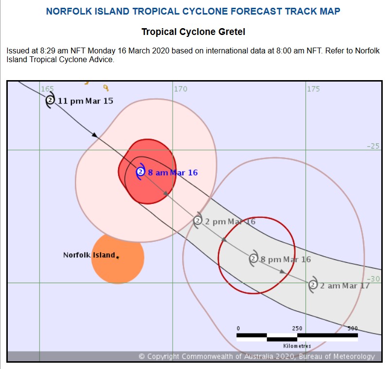
20200316 0829 TL CapeYork track.jpg

Headline:

Tropical Cyclone Gretel is passing to the northeast of Norfolk Island.

Areas affected:

Warning zone: Norfolk Island.

Watch zone: None.

Cancelled zones: None.

Details of Tropical Cyclone Gretel at 8:00 am NFT:

Intensity: category 2, sustained winds near the centre of 100 kilometres per hour with wind gusts to 140 kilometres per hour.
Location: within 85 kilometres of 25.8 degrees South, 168.8 degrees East , 370 kilometres north northeast of Norfolk Island and 460 kilometres south southeast of Noumea .
Movement: southeast at 50 kilometres per hour .

Winds may increase today as Tropical Cyclone Gretel passes well to the northeast of Norfolk Island. Though the system is losing some of its tropical characteristics, it is anticipated to maintain winds equivalent to a category 2 system today. Winds at Norfolk Island are expected to begin easing during Monday evening.

Hazards:

DAMAGING WINDS, with sustained winds in excess of 60-70 km/h and peak gusts in excess of 90 km/h may develop about Norfolk Island, with winds most likely to peak in the early afternoon.

DESTRUCTIVE WINDS, with sustained winds in excess of 90 km/h and peak gusts above 125 km/h are possible over the island on Monday if the cyclone takes a more southerly track.

DAMAGING SURF CONDITIONS, with waves exceeding 5 metres in the surf zone, are likely to produce significant beach erosion.

HEAVY RAINFALL leading to flash flooding is a slight risk during this morning.

Recommended Action:

The Community and Visitors to Norfolk Island should finalise preparations and take shelter.
- Stay out of the water and stay well away from surf-exposed locations.
- Check your property for erosion or inundation by sea water, and if necessary raise goods and electrical items.
- Boats and outside property should be secured.
- Don't walk, ride your bicycle or drive through flood water, and keep clear of creeks and storm drains.
- Information is available from Emergency Management Norfolk Island (+6723 000) or the Norfolk Island Police Force (+6723 22222).
- For emergency assistance call Emergency Management Norfolk Island on +6723 000 (for assistance with storm damage, rising flood water, fallen trees on buildings or roof damage).

Details:
Time (NFT) Intensity Category Latitude
(decimal deg.) Longitude
(decimal deg.) Estimated Position
Accuracy (km)
0hr 8 am March 16 2 25.8S 168.8E 85
+6hr 2 pm March 16 2 27.6S 170.9E 95
+12hr 8 pm March 16 2 29.1S 173.1E 110
+18hr 2 am March 17 2 30.1S 175.3E 130
+24hr 8 am March 17 tropical low XXX XXX XXX
+36hr 8 pm March 17 tropical low XXX XXX XXX
+48hr 8 am March 18 tropical low XXX XXX XXX
+60hr 8 pm March 18 tropical low XXX XXX XXX
+72hr 8 am March 19 tropical low XXX XXX XXX

This warning is also available through TV and Radio broadcasts, the Bureau's website at www.bom.gov.au or call 1300 659 210. The Bureau and Norfolk Island Emergency Services would appreciate this warning being broadcast regularly.

Norfolk Island Time = UTC + 11hrs
Australian Eastern Daylight Time = UTC + 11hrs
Australian Eastern Standard Time = UTC + 10hrs

Next Issue

The next Forecast Track Map will be issued by 12:00 pm NFT Monday


Users browsing this topic
UnknownOceanSpiders 0.0
Forum Jump  
You cannot post new topics in this forum.
You cannot reply to topics in this forum.
You cannot delete your posts in this forum.
You cannot edit your posts in this forum.
You cannot create polls in this forum.
You cannot vote in polls in this forum.

Weather Forum

Weatherzone Forum Alternative

The Weather Forum for Australia

Australian Weather Forum

Weather Forum for Australia, climate change, storm chasing, cyclones, weather photography