Weather Forum
»
Australia Weather
»
Far North Queensland
»
Far North Queensland - Day to Day Weather
Rank: Advanced Member
Groups: Registered
Joined: 5/03/2020(UTC) Posts: 63  Location: el arish Was thanked: 34 time(s) in 20 post(s)
|
Another 80mm here in the past 24 hrs, but it its a beautiful sunny day, looks like it will be much the same for the rest of the week.
they have a top of 34 forecast for tomorrow.......
|
|
|
|
|
|
Rank: Advanced Member
Groups: Registered
Joined: 21/08/2019(UTC) Posts: 364 Location: Cairns Thanks: 249 times
Was thanked: 555 time(s) in 282 post(s)
|
Storm brewed up this arvo, came through with a bit of wind and a few cracks of thunder. Only 5mm here, kept intensifying as it passed, looks to be still going as it moves north and east. |
Records for
2023: 2710mm
2024: 1884mm (no records April-Sept)
2025: 1859mm Jun: 15.4mm |
|
|
|
|
|
Rank: Advanced Member
Groups: Registered
Joined: 12/02/2020(UTC) Posts: 795 Location: Daintree Thanks: 1309 times
Was thanked: 1102 time(s) in 617 post(s)
|
Was a ripper by the time it got up here Ron, How did the beaches go Hickory?
52mm in about 20mins , lots of banging and flashing.
Another beautiful morning, though very warm and sticky.
Cheers
|
|
 1 user thanked FNQ Bunyip for this useful post.
|
|
|
|
Rank: Advanced Member
Groups: Registered
Joined: 27/08/2019(UTC) Posts: 1,111 Location: various, Cairns temporarily Thanks: 2621 times
Was thanked: 894 time(s) in 521 post(s)
|
35°
Feels like the dry season already
|
|
|
|
|
|
Rank: Advanced Member
Groups: Registered
Joined: 21/08/2019(UTC) Posts: 364 Location: Cairns Thanks: 249 times
Was thanked: 555 time(s) in 282 post(s)
|
GFS and EC going for something around march 2-3 |
Records for
2023: 2710mm
2024: 1884mm (no records April-Sept)
2025: 1859mm Jun: 15.4mm |
|
|
|
|
|
Rank: Advanced Member
Groups: Registered
Joined: 21/08/2019(UTC) Posts: 364 Location: Cairns Thanks: 249 times
Was thanked: 555 time(s) in 282 post(s)
|
|
Records for
2023: 2710mm
2024: 1884mm (no records April-Sept)
2025: 1859mm Jun: 15.4mm |
1 user thanked ronfishes for this useful post.
|
|
|
|
Rank: Advanced Member
Groups: Registered
Joined: 21/02/2020(UTC) Posts: 80 Location: Holloways Beach Was thanked: 26 time(s) in 24 post(s)
|
Originally Posted by: FNQ Bunyip 
Was a ripper by the time it got up here Ron, How did the beaches go Hickory?
I got 25.4 mm of it Bunyip. All in a short period of time. A lot was just off the coast, unfortunately - sky was black as and more thunder than lightning. The BoM's weekly WX guesstimate:- Quote:The Madden–Julian Oscillation weakens
A persistent trough across northern Australia is associated with an equatorial Rossby wave, which has helped make broadscale conditions favourable for enhanced tropical weather, comparable to the Madden–Julian Oscillation (MJO).
Equatorial Rossby waves can often be identified by a pair of tropical lows at similar longitudes on both sides of the equator, and currently the southern hemisphere low lies just to the north-west of Darwin. This low is expected to intensify, strengthening a west to northwesterly wind flow around the system and potentially generating local monsoon conditions.
By the time this happens, the monsoonal flow is likely to be well west of the Australian mainland, with minimal influence expected across northern Australia.
|
|
|
|
|
|
Rank: Advanced Member
Groups: Registered
Joined: 21/08/2019(UTC) Posts: 364 Location: Cairns Thanks: 249 times
Was thanked: 555 time(s) in 282 post(s)
|
In a reversal of yesterday GFS is now sending it east and EC into the gulf |
Records for
2023: 2710mm
2024: 1884mm (no records April-Sept)
2025: 1859mm Jun: 15.4mm |
|
|
|
|
|
Rank: Advanced Member
Groups: Registered
Joined: 27/08/2019(UTC) Posts: 1,111 Location: various, Cairns temporarily Thanks: 2621 times
Was thanked: 894 time(s) in 521 post(s)
|
Let's hope the radar is working for the next rain event.
|
|
|
|
|
|
Rank: Advanced Member
Groups: Registered
Joined: 5/03/2020(UTC) Posts: 63 Location: el arish Was thanked: 34 time(s) in 20 post(s)
|
Wonder if we are going to get some "big rains" ? last night after dark i went for a walk down the creek and noticed a big trail of big black ants carrying eggs off to higher ground.....
Last time i saw that happen, we had 500mm in a bit over 12 hrs....
|
|
|
|
|
|
Rank: Advanced Member
Groups: Registered
Joined: 12/02/2020(UTC) Posts: 428 Location: Cairns Was thanked: 822 time(s) in 350 post(s)
|
Originally Posted by: 28degrees Let's hope the radar is working for the next rain event. The radar is working fine, it’s just that BOM have decided to limit the display to 256km to all the radars they have.
|
|
|
|
|
|
Rank: Advanced Member
Groups: Registered
Joined: 27/08/2019(UTC) Posts: 1,111 Location: various, Cairns temporarily Thanks: 2621 times
Was thanked: 894 time(s) in 521 post(s)
|
Originally Posted by: Weary Originally Posted by: 28degrees Let's hope the radar is working for the next rain event. The radar is working fine, it’s just that BOM have decided to limit the display to 256km to all the radars they have. All the radars! Why would they do that? Did you get a response?
|
|
|
|
|
|
Rank: Advanced Member
Groups: Registered
Joined: 21/02/2020(UTC) Posts: 80 Location: Holloways Beach Was thanked: 26 time(s) in 24 post(s)
|
Originally Posted by: Weary Originally Posted by: 28degrees Let's hope the radar is working for the next rain event. The radar is working fine, it’s just that BOM have decided to limit the display to 256km to all the radars they have. The distance from CNS radar to Weipa radar is about 614 km,- so halfway is 307 km which is only 51 km outside the 256 km range of both radars. Surely that's enough coverage to see what's going on on the Cape and in the Gulf. The few km's missing between the two is fairly desolate nothingness. The population in the missing bit wouldn't be many, at all. 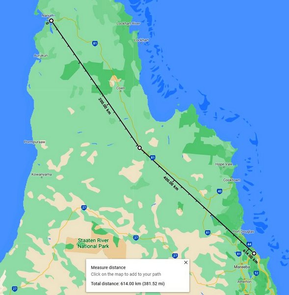
|
|
|
|
|
|
Rank: Advanced Member
Groups: Registered
Joined: 12/02/2020(UTC) Posts: 428 Location: Cairns Was thanked: 822 time(s) in 350 post(s)
|
Hickory, 51 km at the closest point maybe, but we are dealing with arcs. See below, huge areas not covered because of the 256 km limit when the radars can “see” much further than that 
|
1 user thanked Weary for this useful post.
|
|
|
|
Rank: Advanced Member
Groups: Registered
Joined: 12/02/2020(UTC) Posts: 795 Location: Daintree Thanks: 1309 times
Was thanked: 1102 time(s) in 617 post(s)
|
Originally Posted by: Weary Originally Posted by: 28degrees Let's hope the radar is working for the next rain event. The radar is working fine, it’s just that BOM have decided to limit the display to 256km to all the radars they have. Do you have a source or link for that ??? The idea was that they overlap, so as to get the best info. & Hickory, While there might not be many people in the missing bit< I know some of the one that are and they would like the radar to work. It also gives a better incite into what could be coming as systems cross the cape. 6mm here this morning from a few small showers overnight and early this morning. Cheers |
|
1 user thanked FNQ Bunyip for this useful post.
|
|
|
|
Rank: Advanced Member
Groups: Registered
Joined: 27/08/2019(UTC) Posts: 1,111 Location: various, Cairns temporarily Thanks: 2621 times
Was thanked: 894 time(s) in 521 post(s)
|
Another early dry season day by the looks. Not too hot, hasn't gone over 35°.
If I lived on the coast the 256 can tell you plenty, and you get regular rain. We in the less populated areas have completely different conditions and circumstances, and always desperate for rain.
Our weather usually comes from eastwards. But it's the few times from the west we need to know about. You know, whether we should consider driving further up the road or wait a day or too, rather than get trapped between flooded crossings.
|
1 user thanked 28degrees for this useful post.
|
|
|
|
Rank: Advanced Member
Groups: Registered
Joined: 21/08/2019(UTC) Posts: 364 Location: Cairns Thanks: 249 times
Was thanked: 555 time(s) in 282 post(s)
|
Few decent showers coming in this arvo, got a bit wet at Goldsborough.
A lot of those white shaded areas are in radar shadows even if they are at full range. That massive area roughly from Kowanyama -> Coen -> Laura has always lacked coverage for example. |
Records for
2023: 2710mm
2024: 1884mm (no records April-Sept)
2025: 1859mm Jun: 15.4mm |
|
|
|
|
|
Rank: Advanced Member
Groups: Registered
Joined: 21/02/2020(UTC) Posts: 80 Location: Holloways Beach Was thanked: 26 time(s) in 24 post(s)
|
Originally Posted by: Weary Hickory, 51 km at the closest point maybe, but we are dealing with arcs. See below, huge areas not covered because of the 256 km limit when the radars can “see” much further than that
I realise it's an arc, but I just measured off the total distance to see how much was missing. Saddle mountain radar is in a fairly good spot, but Weipa is on a pole at 25 metres at the A/P which is 19 mt AMSL, so maybe not so reliable at or beyond 256 km's. Maybe BoM would rather show coverage they know is accurate, than be abused for data that's not too accurate. Who knows. The visible sat imagery, (or the infrared after dark), would give some idea of what's happening in the blank spots.
|
|
|
|
|
|
Rank: Advanced Member
Groups: Registered
Joined: 12/02/2020(UTC) Posts: 428 Location: Cairns Was thanked: 822 time(s) in 350 post(s)
|
Hmmm. BOM are starting to get excited about the low in the Coral Sea.
|
|
|
|
|
|
Rank: Advanced Member
Groups: Registered
Joined: 21/08/2019(UTC) Posts: 364 Location: Cairns Thanks: 249 times
Was thanked: 555 time(s) in 282 post(s)
|
Considering its been in the models for a few days but their outlook only goes for 3.. A weak and broad low is embedded within the developing monsoon trough in the northwestern Coral Sea. The low is expected to develop over the next few days into next week, the rate dependent on the system's proximity to land, with a favourable environment increasing the likelihood of a tropical cyclone in the region next week. Likelihood of a tropical cyclone in the Eastern Region on: Saturday: Very Low Sunday: Low Monday: Moderate http://www.bom.gov.au/au...harts/viewer/index.shtml |
Records for
2023: 2710mm
2024: 1884mm (no records April-Sept)
2025: 1859mm Jun: 15.4mm |
|
|
|
|
|
Weather Forum
»
Australia Weather
»
Far North Queensland
»
Far North Queensland - Day to Day Weather
Forum Jump
You cannot post new topics in this forum.
You cannot reply to topics in this forum.
You cannot delete your posts in this forum.
You cannot edit your posts in this forum.
You cannot create polls in this forum.
You cannot vote in polls in this forum.
Important Information:
The Weather Forum uses cookies. By continuing to browse this site, you are agreeing to our use of cookies.
More Details
Close
