Weather Forum
»
Australia Weather
»
SEQ and NE NSW
»
Storms for October 18, 19, 20 & 21st 2021
Rank: Advanced Member
Groups: Registered, Administrators Joined: 21/08/2019(UTC) Posts: 941  Location: Brisbane Northside Thanks: 1198 times
Was thanked: 1136 time(s) in 674 post(s)
|
Some decent storms have developed throughout the afternoon. BoM were lagging a little behind in their updates but they got there in the end. Possible tornado near Gladstone was captured but it is a close call on this one. Technically one still shot shows cloud to ground but the video footage is a bit light on, but still the atmosphere over the 2 days is pretty well primed to produce decent storms and supercells. https://www.abc.net.au/n...ast-queensland/100547112 It was always on the cards that the storms would reach the coast in the afternoon as the sea breeze fuelled the band of storms.    The above 3 images just show that bom were a little behind on their updates. But as I was tapping this post out things changed dramatically. Latest update Severe Thunderstorm Warning - Southeast Queensland for LARGE HAILSTONES and HEAVY RAINFALL For people in Logan, Gold Coast and parts of Ipswich, Scenic Rim, Redland City, Sunshine Coast, Brisbane City and Moreton Bay Council Areas. Issued at 3:36 pm Monday, 18 October 2021. The Bureau of Meteorology warns that, at 3:30 pm, severe thunderstorms were detected on the weather radar near Strathpine, Redcliffe, Montville, Bribie Island, Greenbank and Logan Village. They are forecast to affect Coolangatta, Beaudesert and the area southwest of Caloundra by 4:00 pm and Brisbane CBD, Caboolture and Wamuran by 4:30 pm. Heavy rainfall that may lead to flash flooding is the main hazard with these storms. Marginally large hail is also possible. 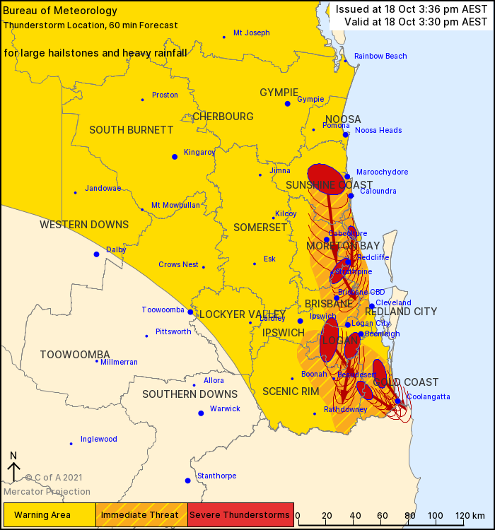 At this stage the modelling has the storms more coastal for Tuesday but it is a wait and see as this could easily change considering the higher temperatures and more fuel from todays rain. Edited by moderator Tuesday, 19 October 2021 6:12:51 PM(UTC)
| Reason: Not specified |
Colin Maitland. |
|
|
|
|
|
Rank: Advanced Member
Groups: Registered, Administrators Joined: 21/08/2019(UTC) Posts: 941 Location: Brisbane Northside Thanks: 1198 times
Was thanked: 1136 time(s) in 674 post(s)
|
A second tornado has been confirmed at Pittsworth by BoM. It hit just before 11:00 am Monday morning. https://www.abc.net.au/n...rnado-and-hail/100548250ABC News reported The Bureau of Meteorology confirmed reports of a tornado at Pittsworth, south-west of Toowoomba, just before 11:00am. "It seemed to be a fairly low-intensity tornado, but [there are] clear signs that it was one," forecaster Shane Kennedy said. "In this case we had both social media photos and video, so we could see some clear rotation and [the tornado] reaching the ground. |
Colin Maitland. |
|
|
|
|
|
Rank: Advanced Member
Groups: Registered, Administrators Joined: 21/08/2019(UTC) Posts: 941 Location: Brisbane Northside Thanks: 1198 times
Was thanked: 1136 time(s) in 674 post(s)
|
The outlook for today is quite borderline and if anything fires up at this stage it would be very coastal. The area between Bowen and Hervey Bay has a greater chance of storm activity and maybe even severe in some places. The 3 images highlights the scenario playing out, and as you can see NSW should have more activity than the SEQ. Most of the storm activity is staying East of the ranges.  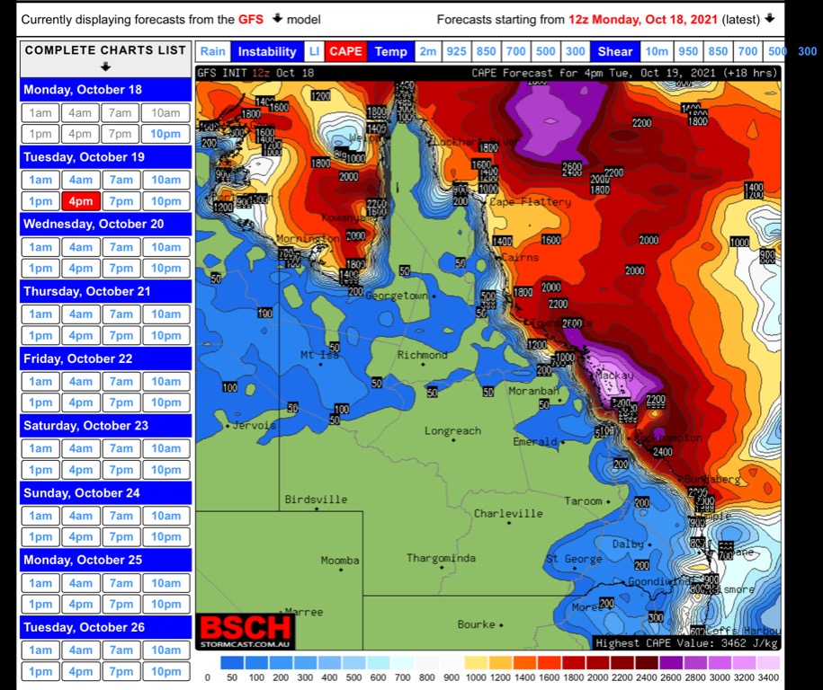  This is the forecast sounding from the modelling for possible storms and it is not looking too good especially with regards to the lack of instability. For some decent activity we would need the sounding to look more like the blue line I have added for the instability. There are other factors involved too. But we just need to wait and see what the 11:00 sounding looks like to gain a better picture.  |
Colin Maitland. |
|
|
|
|
|
Rank: Advanced Member
Groups: Registered, Administrators Joined: 21/08/2019(UTC) Posts: 941 Location: Brisbane Northside Thanks: 1198 times
Was thanked: 1136 time(s) in 674 post(s)
|
2 photos of the hail yesterday with credit to the contributors for each photo.   |
Colin Maitland. |
|
|
|
|
|
Rank: Advanced Member
Groups: Registered, Administrators Joined: 21/08/2019(UTC) Posts: 941 Location: Brisbane Northside Thanks: 1198 times
Was thanked: 1136 time(s) in 674 post(s)
|
With the BoM’s sounding for Brisbane we now have the instability unlike the model sounding . But the big problem is the lack of moisture has increased. It really depends on the sea breeze this afternoon if anything develops. 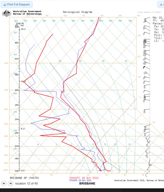 |
Colin Maitland. |
|
|
|
|
|
Rank: Advanced Member
Groups: Registered, Administrators Joined: 21/08/2019(UTC) Posts: 941 Location: Brisbane Northside Thanks: 1198 times
Was thanked: 1136 time(s) in 674 post(s)
|
A few little cells trying hard to form around Oakintgton, Boonah and just south of the border. Most of the action at 15:38 is up towards Hervey Bay and Gladstone with warnings issued for those areas. Bellow is a sweep of the Mt Stapy radar at 15:35. Whether the sea breeze can create enough moisture is the big question other wise we may just see an evening shower with maybe a rumble if anything does eventuate.  |
Colin Maitland. |
|
|
|
|
|
Rank: Advanced Member
Groups: Registered, Administrators Joined: 21/08/2019(UTC) Posts: 941 Location: Brisbane Northside Thanks: 1198 times
Was thanked: 1136 time(s) in 674 post(s)
|
It is interesting watching storm cells and showers develop. With the images below you can see the path that the cells/showers are following. At this point the moisture is feeding from the North East as you can see on the outline on the doppler image. In image 2 you can see the the actual small cells at this point moving towards that moisture. As the afternoon and evening falls the moisture level should increase and give a few places some showers or maybe a rumble or 2.  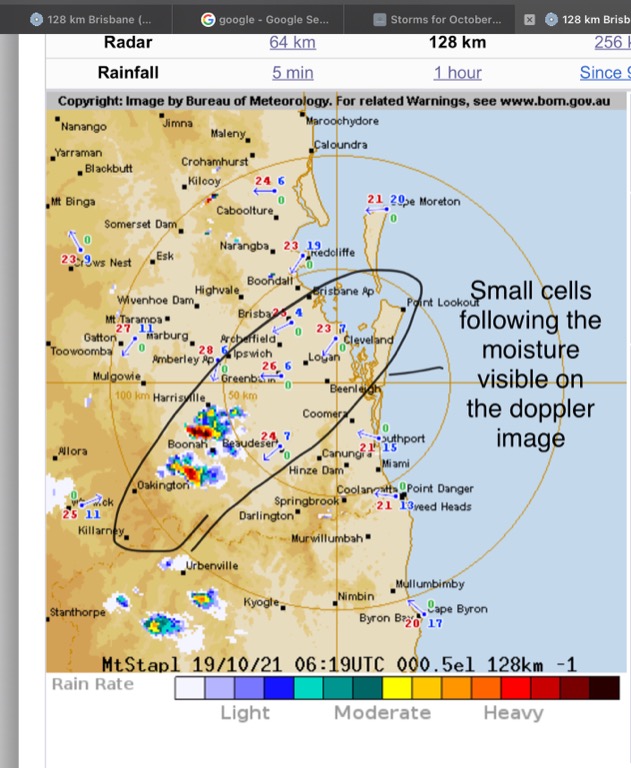 Edited by user Tuesday, 19 October 2021 4:56:39 PM(UTC)
| Reason: Spelling doh |
Colin Maitland. |
|
|
|
|
|
Rank: Advanced Member
Groups: Registered, Administrators Joined: 21/08/2019(UTC) Posts: 941 Location: Brisbane Northside Thanks: 1198 times
Was thanked: 1136 time(s) in 674 post(s)
|
|
Colin Maitland. |
|
|
|
|
|
Rank: Advanced Member
Groups: Registered, Administrators Joined: 21/08/2019(UTC) Posts: 941 Location: Brisbane Northside Thanks: 1198 times
Was thanked: 1136 time(s) in 674 post(s)
|
A decent severe storm around Noosa this evening. TOP PRIORITY FOR IMMEDIATE BROADCAST Severe Thunderstorm Warning - Southeast Queensland for GIANT HAILSTONES and DAMAGING WINDS For people in parts of Gympie and Noosa Council Areas. Issued at 7:18 pm Tuesday, 19 October 2021. The Bureau of Meteorology warns that, at 7:10 pm, severe thunderstorms were detected on the weather radar near the area north of Gympie and Mount Kanighan. These thunderstorms are moving towards the southeast. They are forecast to affect Gympie and Goomboorian by 7:40 pm and the area east of Gympie, the area northeast of Gympie and Pomona by 8:10 pm. Giant hailstones and damaging winds are likely.   |
Colin Maitland. |
|
|
|
|
|
Rank: Advanced Member
Groups: Registered, Administrators Joined: 21/08/2019(UTC) Posts: 941 Location: Brisbane Northside Thanks: 1198 times
Was thanked: 1136 time(s) in 674 post(s)
|
Storms are forecast to fire off around The SEQ and NE NSW from approximately midmorning onwards. Storms are currently present between Bunderberg and Shoalwater Bay. ( image 1) I have used the forecast sounding while waiting for the Brisbane Sounding to arrive. (image 2) I have adjusted a few parameters to match the current observations and as you can see on the sounding there is plenty of cape but moisture is very marginal so at this stage you wouldn’t expect a lot of rain from this system. Tomorrow looks the better of the two storm days ahead.  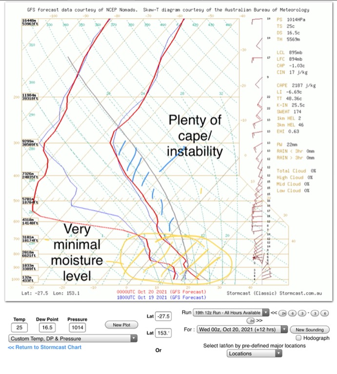 Possible storms/showers from mid to late morning.   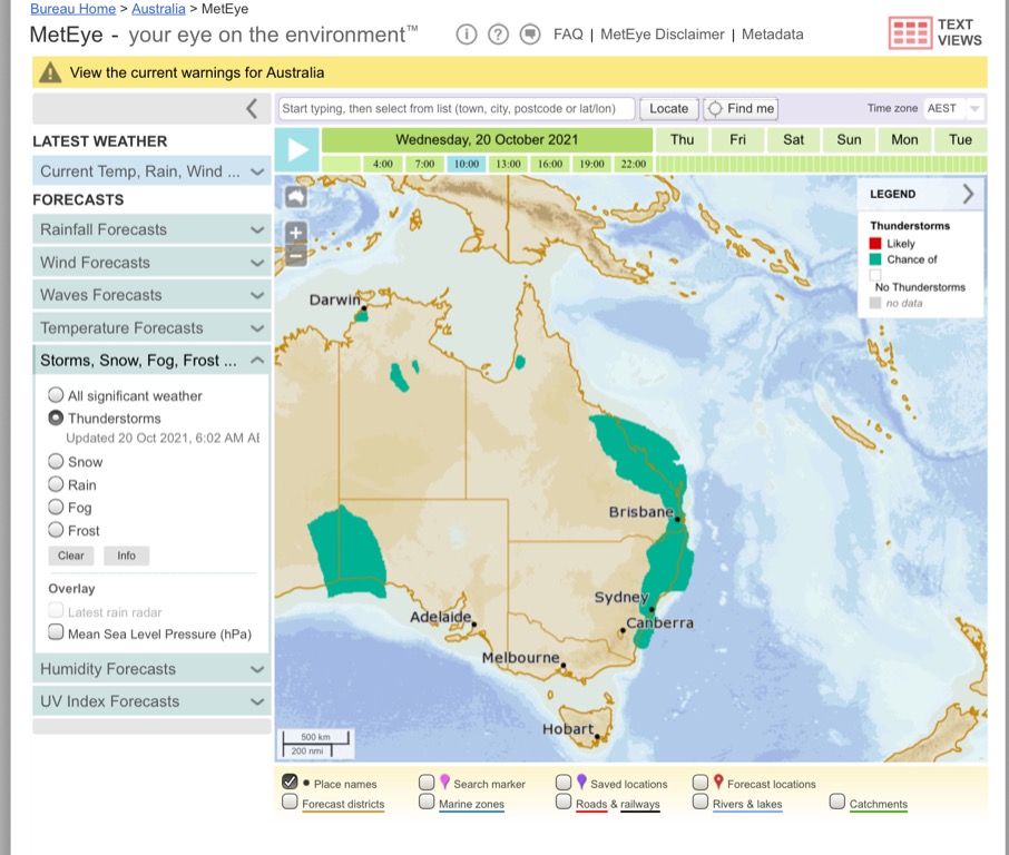 Edited by user Wednesday, 20 October 2021 8:25:11 AM(UTC)
| Reason: Add image |
Colin Maitland. |
|
|
|
|
|
Rank: Advanced Member
Groups: Registered, Administrators Joined: 21/08/2019(UTC) Posts: 941 Location: Brisbane Northside Thanks: 1198 times
Was thanked: 1136 time(s) in 674 post(s)
|
After looking at the latest sounding for Brisbane there is once again an issue with moisture. We should still see some showers or a few storm cells develop. As you can see on the sounding nice cape but moisture is a problem.  Current radar sweep showing no cells or showers developing as early as modelling suggested. But should still develop within the next hour or so and into the afternoon/evening. Not a lot of rain expected. 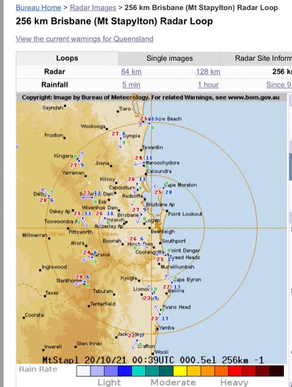 I have added the sounding for Rockhampton and as is visible there is plenty of moisture, in fact it would suggest more of thundery showers as it is a little too saturated now as the storms passed through earlier this morning. 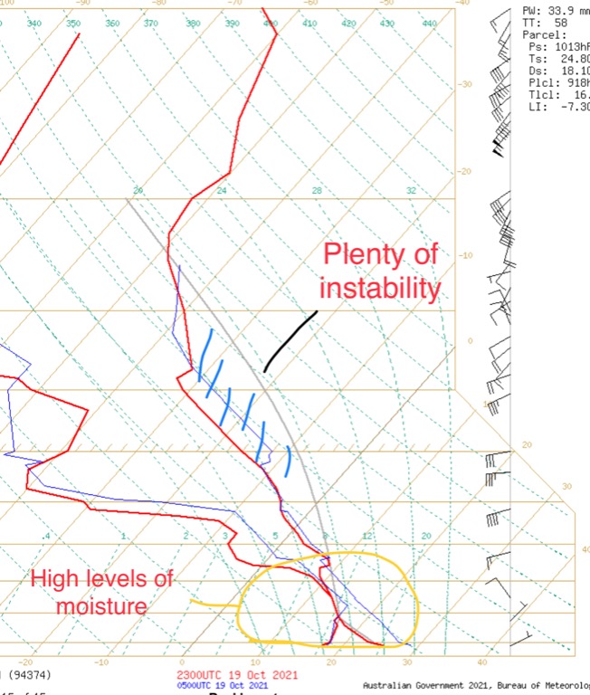 The Rockhampton radar sweep showing activity. 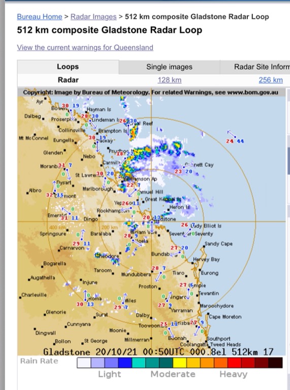 Edited by user Wednesday, 20 October 2021 11:37:47 AM(UTC)
| Reason: Speilink |
Colin Maitland. |
|
|
|
|
|
Rank: Advanced Member
Groups: Registered, Administrators Joined: 21/08/2019(UTC) Posts: 941 Location: Brisbane Northside Thanks: 1198 times
Was thanked: 1136 time(s) in 674 post(s)
|
The radar is being peppered with cells as the front moves towards the east. The satellite imagery shows the cells interacting nicely with the extra moisture coming off the Bay/Ocean.   The doppler showing nice band of moisture and this is also visible on the Mt Stapy radar sweep.  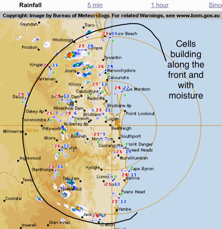 The cell out towards Crows nest has been interesting with a fair bit of rotation as it very slowly moves north east. 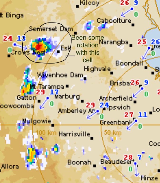 |
Colin Maitland. |
|
|
|
|
|
Rank: Advanced Member
Groups: Registered, Administrators Joined: 21/08/2019(UTC) Posts: 941 Location: Brisbane Northside Thanks: 1198 times
Was thanked: 1136 time(s) in 674 post(s)
|
TOP PRIORITY FOR IMMEDIATE BROADCAST Severe Thunderstorm Warning - Southeast Queensland for DAMAGING WINDS, LARGE HAILSTONES and HEAVY RAINFALL For people in parts of Gympie and Noosa Council Areas. Issued at 1:02 pm Wednesday, 20 October 2021. The Bureau of Meteorology warns that, at 1:00 pm, severe thunderstorms were detected on the weather radar near Imbil. These thunderstorms are moving towards the north to northeast. They are forecast to affect the ranges between Gympie and Murgon and Kandanga by 1:30 pm and the area south of Gympie and Amamoor by 2:00 pm. Damaging winds, large hailstones and heavy rainfall that may lead to flash flooding are likely.  |
Colin Maitland. |
|
|
|
|
|
Rank: Advanced Member
Groups: Registered, Administrators Joined: 21/08/2019(UTC) Posts: 941 Location: Brisbane Northside Thanks: 1198 times
Was thanked: 1136 time(s) in 674 post(s)
|
TOP PRIORITY FOR IMMEDIATE BROADCAST Severe Thunderstorm Warning - Southeast Queensland for DAMAGING WINDS and LARGE HAILSTONES For people in parts of Ipswich, Somerset, Scenic Rim and Brisbane City Council Areas. Issued at 3:14 pm Wednesday, 20 October 2021. The Bureau of Meteorology warns that, at 3:10 pm, severe thunderstorms were detected on the weather radar near Rathdowney and Marburg. These thunderstorms are moving towards the northeast to southeast. They are forecast to affect Lake Manchester by 4:10 pm. Damaging winds and large hailstones are likely.  |
Colin Maitland. |
|
|
|
|
|
Rank: Advanced Member
Groups: Registered, Administrators Joined: 21/08/2019(UTC) Posts: 941 Location: Brisbane Northside Thanks: 1198 times
Was thanked: 1136 time(s) in 674 post(s)
|
Latest update from BoM TOP PRIORITY FOR IMMEDIATE BROADCAST Severe Thunderstorm Warning - Southeast Queensland for DAMAGING WINDS and LARGE HAILSTONES For people in parts of Scenic Rim Council Area. Issued at 4:09 pm Wednesday, 20 October 2021. Plan Image The Bureau of Meteorology warns that, at 4:10 pm, severe thunderstorms were detected on the weather radar near Kooralbyn, Moogerah Dam, Laravale and Moogerah. These thunderstorms are moving towards the southeast. They are forecast to affect Maroon Dam by 4:40 pm and Mount Barney and Lamington National Park by 5:10 pm. Damaging winds and large hailstones are likely.   Edited by user Wednesday, 20 October 2021 4:26:36 PM(UTC)
| Reason: Not specified |
Colin Maitland. |
|
|
|
|
|
Rank: Advanced Member
Groups: Registered, Administrators Joined: 21/08/2019(UTC) Posts: 941 Location: Brisbane Northside Thanks: 1198 times
Was thanked: 1136 time(s) in 674 post(s)
|
BoM’s storm tracker pilot system prediction of current storms and cells  |
Colin Maitland. |
|
|
|
|
|
Rank: Advanced Member
Groups: Registered, Administrators Joined: 21/08/2019(UTC) Posts: 941 Location: Brisbane Northside Thanks: 1198 times
Was thanked: 1136 time(s) in 674 post(s)
|
Meteorology TOP PRIORITY FOR IMMEDIATE BROADCAST Severe Thunderstorm Warning - Southeast Queensland for DAMAGING WINDS, LARGE HAILSTONES and HEAVY RAINFALL For people in parts of Ipswich, Logan, Scenic Rim and Brisbane City Council Areas. Issued at 6:49 pm Wednesday, 20 October 2021.  The Bureau of Meteorology warns that, at 6:45 pm, severe thunderstorms were detected on the weather radar near Bundamba Lagoon. These thunderstorms are moving towards the east to northeast. They are forecast to affect Harrisville and Greenbank by 7:15 pm and Peak Crossing, Logan Village and the area south of Amberley by 7:45 pm. Damaging winds, large hailstones and heavy rainfall that may lead to flash flooding are likely. 45mm has been recorded at Mt Alford in 1 hour. |
Colin Maitland. |
|
|
|
|
|
Rank: Advanced Member
Groups: Registered, Administrators Joined: 21/08/2019(UTC) Posts: 941 Location: Brisbane Northside Thanks: 1198 times
Was thanked: 1136 time(s) in 674 post(s)
|
|
Colin Maitland. |
|
|
|
|
|
Rank: Advanced Member
Groups: Registered, Administrators Joined: 21/08/2019(UTC) Posts: 941 Location: Brisbane Northside Thanks: 1198 times
Was thanked: 1136 time(s) in 674 post(s)
|
Storms firing off very quickly this afternoon. STW are in place TOP PRIORITY FOR IMMEDIATE BROADCAST Severe Thunderstorm Warning - Southeast Queensland for DAMAGING WINDS, LARGE HAILSTONES and HEAVY RAINFALL For people in parts of Logan, Redland City and Moreton Bay Council Areas. Issued at 1:40 pm Thursday, 21 October 2021.  The Bureau of Meteorology warns that, at 1:40 pm, severe thunderstorms were detected on the weather radar near Beachmere. These thunderstorms are slow moving. They are forecast to affect Beenleigh, Deception Bay waters and Bribie Island by 2:40 pm. Damaging winds, large hailstones and heavy rainfall that may lead to flash flooding are likely. Sweep of the radar 128K and 256K from Mt Stapy 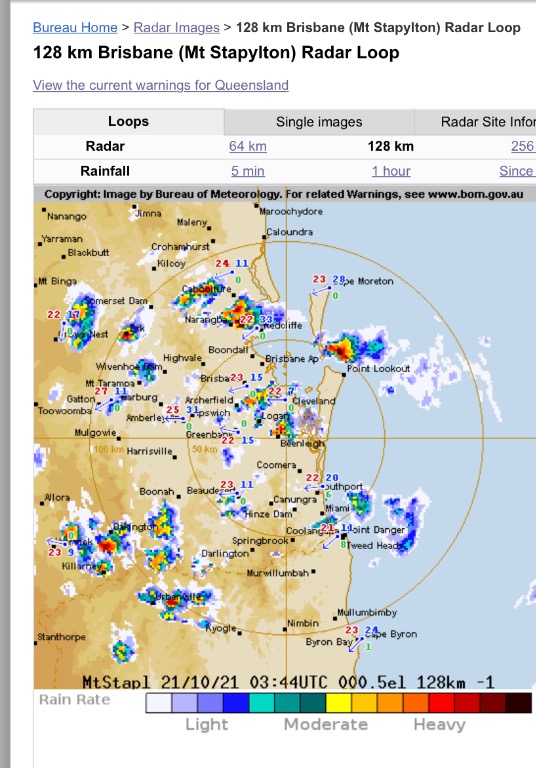 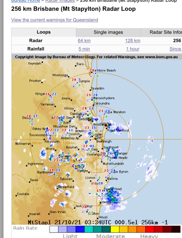 |
Colin Maitland. |
|
|
|
|
|
Weather Forum
»
Australia Weather
»
SEQ and NE NSW
»
Storms for October 18, 19, 20 & 21st 2021
Forum Jump
You cannot post new topics in this forum.
You cannot reply to topics in this forum.
You cannot delete your posts in this forum.
You cannot edit your posts in this forum.
You cannot create polls in this forum.
You cannot vote in polls in this forum.
Important Information:
The Weather Forum uses cookies. By continuing to browse this site, you are agreeing to our use of cookies.
More Details
Close
