Weather Forum
»
Australia Weather
»
Tropical Lows and Cyclones
»
Tropical Low 05U-15 January / Cyclone Kirrily (24/01)/Ex Kirrily2024
Rank: Advanced Member
Groups: Registered, Administrators Joined: 21/08/2019(UTC) Posts: 942  Location: Brisbane Northside Thanks: 1198 times
Was thanked: 1136 time(s) in 674 post(s)
|
Latest update on the Tropical Low. I posted 5 hours ago and the Low was 690 kilometres east northeast of Townsville. Since then it has moved 20 kilometres closer. It is now 670 kilometres east northeast of Townsville TOP PRIORITY FOR IMMEDIATE BROADCAST TROPICAL CYCLONE ADVICE NUMBER 13 Issued at 10:47 am EST on Wednesday 24 January 2024 Headline: Tropical cyclone impacts likely to begin for coastal and island communities tonight and Thursday morning. Areas Affected: Warning Zone Ayr to Sarina, including Mackay, Bowen and the Whitsunday Islands . Watch Zone Innisfail to Ayr, including Townsville and extending inland to Charters Towers. Cancelled Zone None. Details of Tropical Low at 10:00 am AEST: Intensity: Tropical Low, sustained winds near the centre of 75 kilometres per hour with wind gusts to 100 kilometres per hour. Location: within 45 kilometres of 17.1 degrees South 152.7 degrees East, estimated to be 670 kilometres east northeast of Townsville and 580 kilometres northeast of Mackay. Movement: slow moving. A tropical low (05U) is developing slowly in the central Coral Sea and is expected to become a tropical cyclone tonight as it tracks west southwest towards the Queensland coast. The system is likely to cross the Queensland coast Thursday night between Cardwell and Bowen as a Category 2 system. In the longer term, the system is likely to track further inland as a tropical low, bringing heavy to intense rain to parts of central and western Queensland.  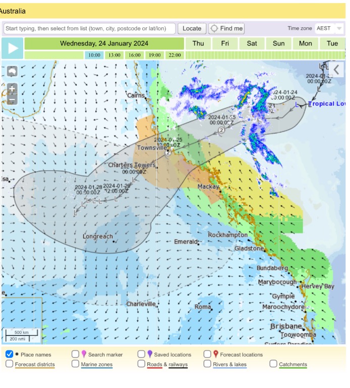 Edited by user Wednesday, 24 January 2024 11:47:56 AM(UTC)
| Reason: Lost some info when posting.lol |
Colin Maitland. |
 1 user thanked Colmait for this useful post.
|
|
|
|
Rank: Advanced Member
Groups: Registered, Administrators Joined: 21/08/2019(UTC) Posts: 942 Location: Brisbane Northside Thanks: 1198 times
Was thanked: 1136 time(s) in 674 post(s)
|
Latest update take away notes. It has moved 10 kilometers in 3 hours.
TOP PRIORITY FOR IMMEDIATE BROADCAST
TROPICAL CYCLONE ADVICE NUMBER 14
Issued at 1:46 pm EST on Wednesday 24 January 2024
Headline:
Tropical cyclone impacts likely to begin for coastal and island communities tonight and Thursday morning.
Areas Affected:
Warning Zone
Lucinda to Sarina, including Townsville, Mackay, Bowen and the Whitsunday Islands .
Watch Zone
Innisfail to Lucinda, and extending inland to Charters Towers .
Cancelled Zone
None.
Details of Tropical Low at 1:00 pm AEST:
Intensity: Tropical Low, sustained winds near the centre of 75 kilometres per hour with wind gusts to 100 kilometres per hour.
Location: within 45 kilometres of 17.2 degrees South 152.6 degrees East, estimated to be 660 kilometres east northeast of Townsville and 570 kilometres northeast of Mackay.
Movement: slow moving.
A tropical low (05U) is developing slowly in the central Coral Sea and is expected to become a tropical cyclone tonight as it tracks west southwest towards the Queensland coast. The system is likely to cross the Queensland coast Thursday night between Cardwell and Bowen as a Category 2 system.
In the longer term, the system is likely to track further inland as a tropical low, bringing heavy to intense rain to parts of the northern interior and western Queensland.
|
Colin Maitland. |
1 user thanked Colmait for this useful post.
|
|
|
|
Rank: Advanced Member
Groups: Registered, Administrators Joined: 21/08/2019(UTC) Posts: 942 Location: Brisbane Northside Thanks: 1198 times
Was thanked: 1136 time(s) in 674 post(s)
|
Just for the records. Track path for latest advise and satellite image.   |
Colin Maitland. |
1 user thanked Colmait for this useful post.
|
|
|
|
Rank: Advanced Member
Groups: Registered, Administrators Joined: 21/08/2019(UTC) Posts: 942 Location: Brisbane Northside Thanks: 1198 times
Was thanked: 1136 time(s) in 674 post(s)
|
Latest update. The Low has now been officially named as Cyclone Kirrily.
TOP PRIORITY FOR IMMEDIATE BROADCAST
TROPICAL CYCLONE ADVICE NUMBER 15
Issued at 4:49 pm EST on Wednesday 24 January 2024
Headline:
Impacts from Tropical Cyclone Kirrily likely to begin for coastal and island communities tonight and Thursday morning.
Areas Affected:
Warning Zone
Cardwell to Sarina, including Townsville, Mackay, Bowen, the Whitsunday Islands, and extending inland to Charters Towers.
Watch Zone
Innisfail to Cardwell.
Cancelled Zone
None.
Details of Tropical Cyclone Kirrily at 4:00 pm AEST:
Intensity: Category 1, sustained winds near the centre of 75 kilometres per hour with wind gusts to 100 kilometres per hour.
Location: within 55 kilometres of 17.4 degrees South 152.4 degrees East, estimated to be 630 kilometres east northeast of Townsville and 530 kilometres northeast of Mackay.
Movement: slow moving.
Tropical Cyclone Kirrily has developed in the central Coral Sea, and is expected to continue strengthening as it tracks west southwest towards the Queensland coast. The system is likely to cross the Queensland coast Thursday night between Cardwell and Bowen as a Category 2 system.
In the longer term, the system is likely to track further inland as a tropical low, bringing heavy to intense rain to parts of the northern interior and western Queensland. |
Colin Maitland. |
1 user thanked Colmait for this useful post.
|
|
|
|
Rank: Advanced Member
Groups: Registered, Administrators Joined: 21/08/2019(UTC) Posts: 942 Location: Brisbane Northside Thanks: 1198 times
Was thanked: 1136 time(s) in 674 post(s)
|
Satellite image 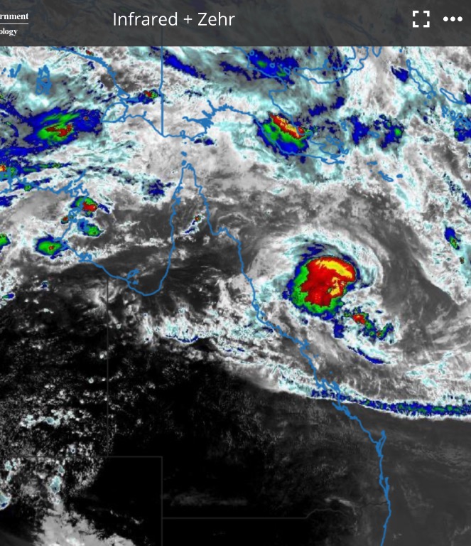  |
Colin Maitland. |
2 users thanked Colmait for this useful post.
|
|
|
|
Rank: Advanced Member
Groups: Registered, Administrators Joined: 21/08/2019(UTC) Posts: 942 Location: Brisbane Northside Thanks: 1198 times
Was thanked: 1136 time(s) in 674 post(s)
|
Latest update for Cyclone Kirrily TOP PRIORITY FOR IMMEDIATE BROADCAST TROPICAL CYCLONE ADVICE NUMBER 22 Issued at 10:59 am EST on Thursday 25 January 2024 Headline: Tropical Cyclone Kirrily to cross the coast near Townsville tonight. Gales now occurring over Whitsunday Islands, to extend to the mainland today. Areas Affected: Warning Zone Innisfail to Sarina, including Townsville,Mackay, Bowen, the Whitsunday Islands, and extending inland to Charters Towers. Watch Zone None. Cancelled Zone None. Details of Tropical Cyclone Kirrily at 11:00 am AEST: Intensity : Category 2, sustained winds near the centre of 95 kilometres per hour with wind gusts to 130 kilometres per hour. Location: within 35 kilometres of 18.3 degrees South 149.0 degrees East, estimated to be 260 kilometres east northeast of Townsville and 315 kilometres north of Mackay. Movement: west southwest at 18 kilometres per hour. Tropical Cyclone Kirrily is expected to continue strengthening as it tracks west southwest towards the Queensland coast. Kirrily will cross the Queensland coast tonight, in the vicinity of Townsville, as a Category 2 system then weaken on Friday as it moves inland. From Friday, Kirrily is likely to track further inland as a tropical low, resulting in heavy to intense rain to parts of the northern interior and western Queensland. 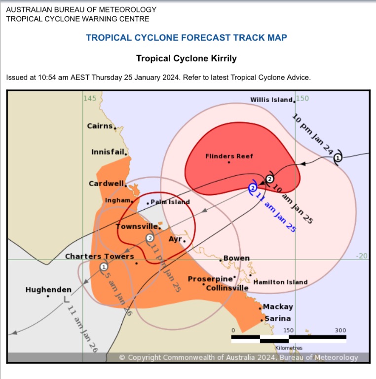  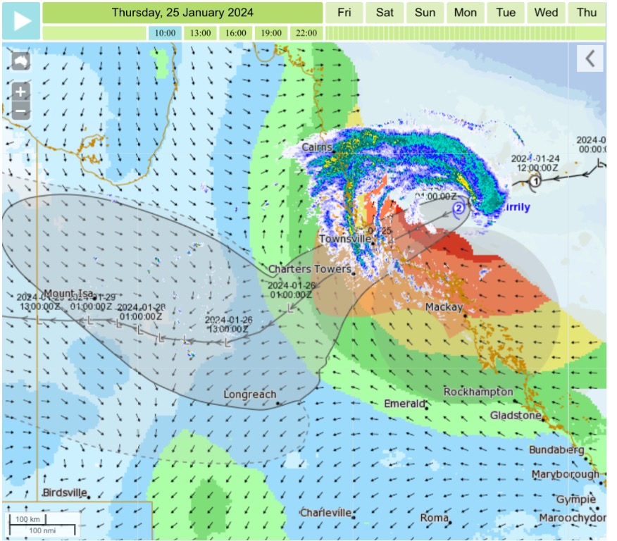 |
Colin Maitland. |
2 users thanked Colmait for this useful post.
|
|
|
|
Rank: Advanced Member
Groups: Registered, Administrators Joined: 21/08/2019(UTC) Posts: 942 Location: Brisbane Northside Thanks: 1198 times
Was thanked: 1136 time(s) in 674 post(s)
|
Latest update.. SEWS to be used in media release as of now.
Transmitters serving the area between Ingham and Bowen including Townsville and Ayr are requested to USE the Standard Emergency Warning Signal before broadcasting the following warning.
TOP PRIORITY FOR IMMEDIATE BROADCAST
TROPICAL CYCLONE ADVICE NUMBER 26
Issued at 2:53 pm EST on Thursday 25 January 2024
Headline:
Severe Tropical Cyclone Kirrily to cross the coast near Townsville tonight. Gales now occurring over Whitsunday Islands, to extend to the mainland today.
Areas Affected:
Warning Zone
Innisfail to Sarina, including Townsville, Mackay, Bowen, the Whitsunday Islands, and extending inland to Charters Towers.
Watch Zone
None.
Cancelled Zone
None.
Details of Severe Tropical Cyclone Kirrily at 3:00 pm AEST:
Intensity: Category 3, sustained winds near the centre of 120 kilometres per hour with wind gusts to 165 kilometres per hour.
Location: within 30 kilometres of 18.5 degrees South 148.0 degrees East, estimated to be 155 kilometres east northeast of Townsville and 320 kilometres north northwest of Mackay.
Movement: west southwest at 22 kilometres per hour.
Severe Tropical Cyclone Kirrily is expected to track west southwest towards the Queensland coast. Kirrily will cross the Queensland coast tonight, in the vicinity of Townsville, as a Category 3 system then weaken on Friday as it moves inland.
From Friday, Kirrily is likely to track further inland as a tropical low, resulting in heavy to intense rain to parts of the northern interior and western Queensland.
|
Colin Maitland. |
1 user thanked Colmait for this useful post.
|
|
|
|
Rank: Advanced Member
Groups: Registered, Administrators Joined: 21/08/2019(UTC) Posts: 942 Location: Brisbane Northside Thanks: 1198 times
Was thanked: 1136 time(s) in 674 post(s)
|
Satellite imagery.   And good old BoM with their radar sites. Mackay radar is out. This happens all the time down here at Mt Stapylton. Multi million dollar s[censored]heap. S c r a p.  Edited by user Thursday, 25 January 2024 3:12:24 PM(UTC)
| Reason: Since when is scrap a censored word. Or just in case S c r a p |
Colin Maitland. |
1 user thanked Colmait for this useful post.
|
|
|
|
Rank: Advanced Member
Groups: Registered, Administrators Joined: 21/08/2019(UTC) Posts: 942 Location: Brisbane Northside Thanks: 1198 times
Was thanked: 1136 time(s) in 674 post(s)
|
Latest advise on Cyclone Kirrily, now a Cat. 3 system. TOP PRIORITY FOR IMMEDIATE BROADCAST TROPICAL CYCLONE ADVICE NUMBER 28 Issued at 4:56 pm EST on Thursday 25 January 2024 Headline: Severe Tropical Cyclone Kirrily to cross the coast near Townsville tonight. Gales now occurring over Whitsunday Islands, and are beginning for some mainland locations. Areas Affected: Warning Zone Innisfail to Sarina, including Townsville, Mackay, Bowen, the Whitsunday Islands, and extending inland to Charters Towers . Watch Zone None. Cancelled Zone None. Details of Severe Tropical Cyclone Kirrily at 5:00 pm AEST: Intensity: Category 3, sustained winds near the centre of 120 kilometres per hour with wind gusts to 165 kilometres per hour. Location: within 30 kilometres of 18.8 degrees South 147.4 degrees East, estimated to be 85 kilometres northeast of Townsville and 320 kilometres northwest of Mackay. Movement: west southwest at 25 kilometres per hour. Severe Tropical Cyclone Kirrily is expected to track west southwest towards the Queensland coast. Kirrily will cross the Queensland coast tonight, in the vicinity of Townsville, as a Category 3 system, then weaken on Friday as it moves inland. From Friday, the system is likely to track further inland as a tropical low, resulting in heavy to intense rain and possible damaging winds to parts of the northern interior and western Queensland. 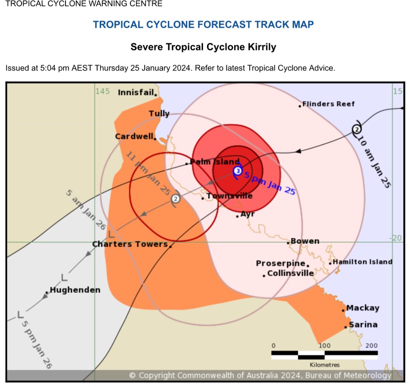 Edited by user Thursday, 25 January 2024 5:23:37 PM(UTC)
| Reason: Not specified |
Colin Maitland. |
1 user thanked Colmait for this useful post.
|
|
|
|
Rank: Advanced Member
Groups: Registered, Administrators Joined: 21/08/2019(UTC) Posts: 942 Location: Brisbane Northside Thanks: 1198 times
Was thanked: 1136 time(s) in 674 post(s)
|
Water vapour image at 1702. Interesting how big this system is getting. A lot of moisture can be seen from the water vapour and the severity of the Cyclone. Unfortunately you would expect wide spread flooding right through to Mt Isa and into the NT. Townsville and surrounding areas are going to be in for a very rough evening/night. Some very strong wind gust already recorded. Still no wall eye development can be seen on the satellite imagery at this point in time. Wave heights to 20 feet and wind gusts to 175km/h.  |
Colin Maitland. |
1 user thanked Colmait for this useful post.
|
|
|
|
Rank: Advanced Member
Groups: Registered, Administrators Joined: 21/08/2019(UTC) Posts: 942 Location: Brisbane Northside Thanks: 1198 times
Was thanked: 1136 time(s) in 674 post(s)
|
TC Kirrily managed to develop an eye at approx 19:20 just before crossing the Coast.  |
Colin Maitland. |
1 user thanked Colmait for this useful post.
|
|
|
|
Rank: Advanced Member
Groups: Registered, Administrators Joined: 21/08/2019(UTC) Posts: 942 Location: Brisbane Northside Thanks: 1198 times
Was thanked: 1136 time(s) in 674 post(s)
|
|
Colin Maitland. |
1 user thanked Colmait for this useful post.
|
|
|
|
Rank: Advanced Member
Groups: Registered, Administrators Joined: 21/08/2019(UTC) Posts: 942 Location: Brisbane Northside Thanks: 1198 times
Was thanked: 1136 time(s) in 674 post(s)
|
Cairns radar and WATL rain forecast .   |
Colin Maitland. |
3 users thanked Colmait for this useful post.
|
|
|
|
Rank: Advanced Member
Groups: Registered, Administrators Joined: 21/08/2019(UTC) Posts: 942 Location: Brisbane Northside Thanks: 1198 times
Was thanked: 1136 time(s) in 674 post(s)
|
Final figures from the peaks of wind was 96km/h from 5:53 -6:04 pm. The lowest reading of the cental pressure was 989 HPa at 9:56pm. It crossed the Coast as a Cat 2 storm so it lost a little strength as it did reach a Cat 3 rating. Total rainfall for the system was 27.8 mm. It was downgraded fairly quickly to a tropical Low and is now travelling Westwards. 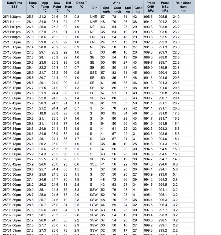  |
Colin Maitland. |
3 users thanked Colmait for this useful post.
|
|
|
|
Rank: Advanced Member
Groups: Registered, Administrators Joined: 21/08/2019(UTC) Posts: 942 Location: Brisbane Northside Thanks: 1198 times
Was thanked: 1136 time(s) in 674 post(s)
|
 Ex-Tropical Cyclone Kirrily is currently located over the southwestern Gulf Country near the Northern Territory border, and is slowly moving to the south-southwest. The system will continue to track to the south close to the Queensland and Northern Territory border during the weekend. At this stage the system and its associated severe weather are expected to move through the North West district during today and into the Channel Country early Sunday morning, although some uncertainty remains with its exact track in the longer term. HEAVY RAINFALL which may lead to FLASH FLOODING is expected in western parts of the Gulf Country, North West and Channel Country districts. Six-hourly rainfall totals between 80 and 150 mm are likely, more likely near the Queensland and Northern Territory border. 24-hourly totals between 150 and 250 mm with isolated falls of 300mm are possible. Locally INTENSE RAINFALL which may lead to DANGEROUS AND LIFE-THREATENING FLASH FLOODING is also possible close to the low, particularly on the southern and western sides of the system. Isolated six-hourly totals between 150 and 200 mm are possible with 24-hourly totals exceeding 300 mm. A separate Severe Thunderstorm Warning will be issued if VERY DANGEROUS THUNDERSTORMS with INTENSE RAINFALL are detected. DAMAGING WIND GUSTS in excess of 90 km/h are also possible across the warning area, particularly associated with thunderstorms and heavy showers. A Flood Watch and several Flood Warnings are also current for the Central West, Channel Country and Gulf of Carpentaria catchments. See http://www.bom.gov.au/qld/warnings/ for more information. Locations which may be affected include Doomadgee, Camooweal, Urandangi, Gregory Downs Station, Westmoreland Station and Lawn Hill. Latest significant observations: 332 mm was observed at Westmoreland Station in 24 hours to 9 am Friday. 150 mm was observed at Mornington Island Airport in 24 hours to 9 am Friday. Gale force winds with a peak wind gust of 94 km/h recorded at Mornington Island Airport at 7:35 am Friday. 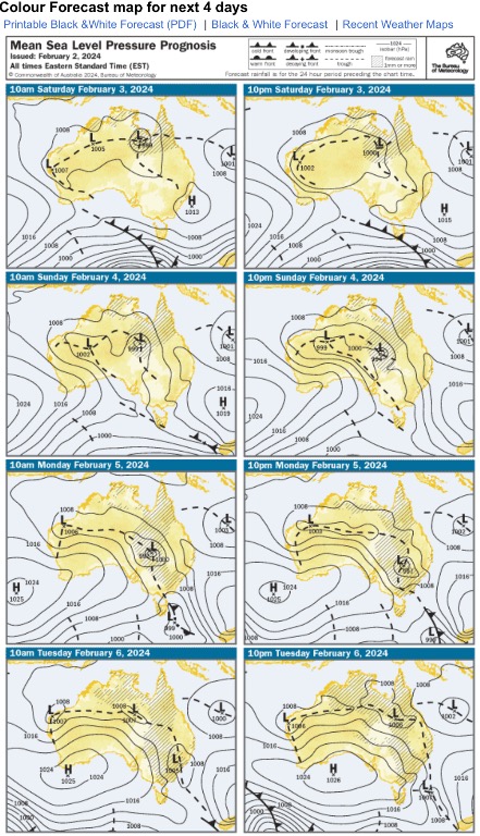 |
Colin Maitland. |
|
|
|
|
|
Rank: Advanced Member
Groups: Registered, Administrators Joined: 21/08/2019(UTC) Posts: 942 Location: Brisbane Northside Thanks: 1198 times
Was thanked: 1136 time(s) in 674 post(s)
|
Water vapour imagery of Ex Kirrily and satellite imagery  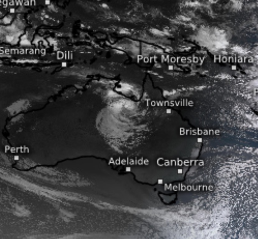 Edited by user Saturday, 3 February 2024 6:38:23 AM(UTC)
| Reason: Not specified |
Colin Maitland. |
|
|
|
|
|
Rank: Advanced Member
Groups: Registered
Joined: 12/02/2020(UTC) Posts: 794 Location: Daintree Thanks: 1308 times
Was thanked: 1099 time(s) in 616 post(s)
|
Well she has been an interesting system. And she is hanging on and delivering plenty of rain again.
She's a stayer.
Cheers
|
|
2 users thanked FNQ Bunyip for this useful post.
|
|
|
|
Rank: Advanced Member
Groups: Registered
Joined: 27/08/2019(UTC) Posts: 1,110 Location: various, Cairns temporarily Thanks: 2617 times
Was thanked: 893 time(s) in 520 post(s)
|
|
1 user thanked 28degrees for this useful post.
|
|
|
|
Rank: Advanced Member
Groups: Registered
Joined: 12/02/2020(UTC) Posts: 794 Location: Daintree Thanks: 1308 times
Was thanked: 1099 time(s) in 616 post(s)
|
Originally Posted by: 28degrees  Lets give it it's own thread 28° after all it's been named now ... Cheers |
|
|
|
|
|
|
Rank: Advanced Member
Groups: Registered
Joined: 27/08/2019(UTC) Posts: 1,110 Location: various, Cairns temporarily Thanks: 2617 times
Was thanked: 893 time(s) in 520 post(s)
|
Oops. Wrong thread anyway....😱
|
|
|
|
|
|
Weather Forum
»
Australia Weather
»
Tropical Lows and Cyclones
»
Tropical Low 05U-15 January / Cyclone Kirrily (24/01)/Ex Kirrily2024
Forum Jump
You cannot post new topics in this forum.
You cannot reply to topics in this forum.
You cannot delete your posts in this forum.
You cannot edit your posts in this forum.
You cannot create polls in this forum.
You cannot vote in polls in this forum.
Important Information:
The Weather Forum uses cookies. By continuing to browse this site, you are agreeing to our use of cookies.
More Details
Close
