Weather Forum
»
Australia Weather
»
SEQ and NE NSW
»
SE QLD and NE NSW - Day to Day Weather
Rank: Advanced Member
Groups: Registered
Joined: 13/09/2019(UTC)
Posts: 118
Location: Caboolture (the next Las Vegas!)
Thanks: 215 times
Was thanked: 297 time(s) in 100 post(s)
|
Hello everyone!
I used to be a WZ forum person a few years ago and didn't see that it had closed down until today. Bit of a shock...
Anyway, I checked out the other forums, but didn't like the colours so ended up on this one. (Bit like my wife buying a car!)
Anyway, I thought I would say "Hi" from dry and slightly dusty Caboolure!
|
 7 users thanked DelBoy for this useful post.
|
|
|
|
Rank: Advanced Member
Groups: Registered
Joined: 2/09/2019(UTC) Posts: 105  Location: Brisbane Thanks: 145 times
Was thanked: 561 time(s) in 103 post(s)
|
|
4 users thanked Ken for this useful post.
|
|
|
|
Rank: Advanced Member
Groups: Registered
Joined: 21/08/2019(UTC) Posts: 185 Location: Ocean View Thanks: 359 times
Was thanked: 539 time(s) in 161 post(s)
|
Hey DelBoy and thank you for joining up. So good to have a fellow "northern suburbs" person here.
I got home this evening and there is a strong smell of smoke and quite poor visibility up here in Ocean View. We have had the wind swinging around from SW, to NW, to E and SE all day, so I don't know where it came from.
Hopefully tomorrow passes without any new fires popping up.
Ken, has there been any consistent trend in the Ensemble data for the possible rain later this month, which you showed us last night?
|
3 users thanked Pabloako for this useful post.
|
|
|
|
Rank: Advanced Member
Groups: Registered
Joined: 26/08/2019(UTC) Posts: 50 Location: Perth Thanks: 74 times
Was thanked: 56 time(s) in 20 post(s)
|
NASA noting the NE NSW fires
|
5 users thanked thunderman for this useful post.
|
|
|
|
Rank: Advanced Member
Groups: Registered
Joined: 25/08/2019(UTC) Posts: 1,839 Location: Ferny Grove Thanks: 985 times
Was thanked: 856 time(s) in 419 post(s)
|
|
|
4 users thanked Falling_Droplet for this useful post.
|
|
|
|
Rank: Advanced Member
Groups: Registered
Joined: 21/08/2019(UTC) Posts: 185 Location: Ocean View Thanks: 359 times
Was thanked: 539 time(s) in 161 post(s)
|
It's a lovely start to the day up here. I originally thought smoke had returned, however it was a lovely mist with a heavy dew on the ground. It is starting to lift now and a warm sunny day ahead. 
|
6 users thanked Pabloako for this useful post.
|
|
|
|
Rank: Advanced Member
Groups: Registered
Joined: 21/08/2019(UTC) Posts: 182 Location: Wynnum North Thanks: 656 times
Was thanked: 381 time(s) in 167 post(s)
|
WYNNUM NORTH ( 27.4S 153.2E ) - WEATHER
DATE....14 SEP 2019...TIME...0750
CURRENT TEMPERATURE...16.0C
CURRENT HUMIDITY........80%
CURRENT DEW POINT.......13C
CURRENT WIND DIR/SPEED..WNW 5Kph
CURRENT MSL PRESSURE...1023.2Hpa
CURRENT VISIBILITY.....18KM
CURRENT CLOUD..........Nil
CURRENT WEATHER......Smoke haze
RAIN SINCE 0900 FRIDAY..0.0mm
SUMMARY LAST 24 HOURS
YESTERDAY'S MAX TEMP. .......29.6C
THIS MORNING'S MIN TEMP......11.2C
PAST 24 HOURS TEMP ANOMALY..+1.80C
THIS MORNING'S GRASS MIN......9.0C
AVERAGE 24 HOUR DEW POINT.......7C
AVERAGE 24 HOUR MSLP........1020.6Hpa
MAX WIND GUST LAST 24 HOURS..SE 34Kph at 1856
PAST 24 HR SIGNIFICANT WEATHER..Thick smoke haze developed Friday morning, but partially thinned out late morning with the arrival of a dry SW change. Early morning mist Saturday, with smoke haze continuing. |
Wyn Nth 2020-Jan165, |
3 users thanked retired weather man for this useful post.
|
|
|
|
Rank: Advanced Member
Groups: Registered
Joined: 25/08/2019(UTC) Posts: 1,839 Location: Ferny Grove Thanks: 985 times
Was thanked: 856 time(s) in 419 post(s)
|
Ferny Grove Weather
Date: 14 Sep 2019
Time: 8:10 AM
Min Temp since 9am yesterday: 10.9 C
Max Temp since 9am yesterday: 30.7 C
Min Ground Temp: 8.9 C
Rain since 9am yesterday: 0 mm
Temperature: 19.9 C
Relative Humidity: 73 %
Dew Point: 15 C
MSL Pressure: 1022.5 hPa
Wind Speed: Calm
Wind Direction: Calm
Present Weather: Haze
Visibility: 20km to 39km - Very Good Visibility
Cloud Cover: 0/8
Ground State: Ground dry
Notes of yesterday weather - 13/9/19: Fine and sunny. Smoke haze. Some limited cu clouds later in the morning and clearing in afternoon. A cool morning and a hot day. Moderately low and stable dew point early then rose to near average in the early morning before starting to fall. The dew point fell faster from 9am and fell through to the afternoon and became very low to a minimum of -24 C for a brief period. From mid afternoon the dew point rose becoming stable and moderately low later in the evening. Relative humidity fell quickly from 8am and became low in the afternoon and was around 5% between 12pm and 3 pm and briefly between 2 and 5%. In the evening the relative humidity recovered to moderately low. Light and variable winds at times early before light SE to NE winds in the early morning before a dry W to SW change at 9am. SSW to W winds in the afternoon, SSE to ESE from mid afternoon becoming calm in the evening.
Today: Light NNE to NW winds have started in the last hour hour after mostly calm winds overnight. The temperature fell only slowly early and the dew point have been rising and now near average and is much higher than it has been. Relative humidity have returned to near average.
|
|
3 users thanked Falling_Droplet for this useful post.
|
|
|
|
Rank: Advanced Member
Groups: Registered
Joined: 24/08/2019(UTC) Posts: 292 Location: Country Victorian Thanks: 580 times
Was thanked: 503 time(s) in 194 post(s)
|
Noticing both RWM and FD had maximums up around 30deg c yesterday. Significantly warm Coolongatta obs' at 11.30am at Coolongatta is 26.5. The increased warmth is very noticeable today.,The plants in the garden in the sun now say so. Nice to see a small climb in dew point even with a NW this morning and SW yesterday. 8.5deg c dp, currently. A photo l took yesterday showing a smoke haze out to sea. Significantly thicker out the hinterlands (From the M1.Tweed river at chinderah looking east) I think we were doing about 80km/hr when l took that.  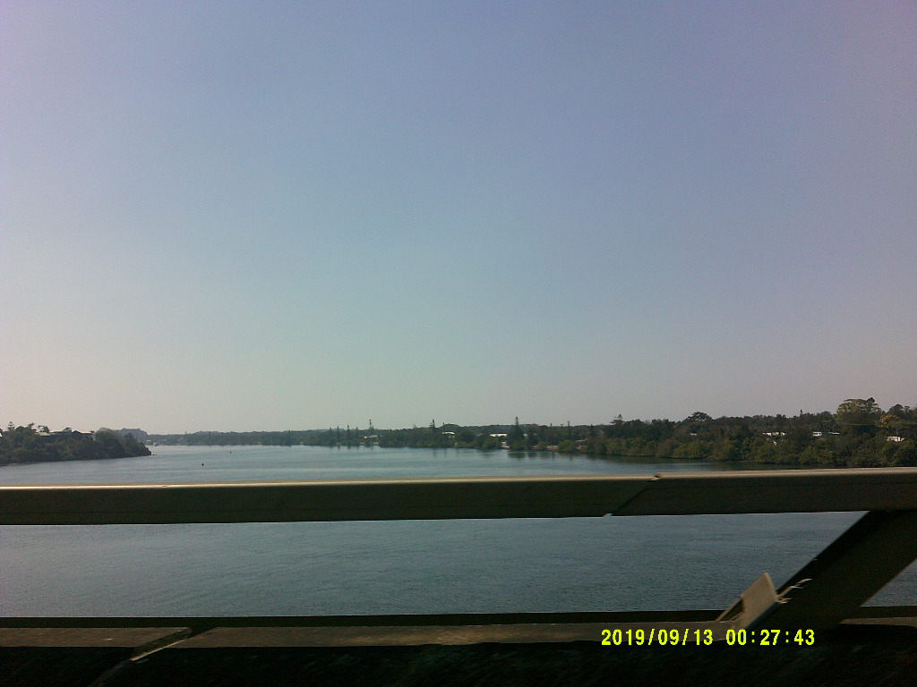
|
4 users thanked crikey for this useful post.
|
|
|
|
Rank: Advanced Member
Groups: Registered
Joined: 24/08/2019(UTC) Posts: 292 Location: Country Victorian Thanks: 580 times
Was thanked: 503 time(s) in 194 post(s)
|
Oh Good..
ACC g has a 2 day event to keep is amused. Mainly coastal and ranges but time for adjustments.
..........
T+96hrs ACC g
Surface trough with tropical dip in isobars . Later, possibly forming an onshore low.
From Tuesday 17th sept and into 18th Sept .I will guess some storm activity.
and then after that on thursday 19th, we have an easterly moist onshore stream from the Tasman possibly giving some coastal actvity on the thursday. http://www.bom.gov.au/au...harts/viewer/index.shtml http://www.bom.gov.au/au...harts/viewer/index.shtml
|
7 users thanked crikey for this useful post.
|
|
|
|
Rank: Administration
Groups: Administrators
Joined: 9/08/2019(UTC)
Posts: 70
Thanks: 151 times
Was thanked: 98 time(s) in 41 post(s)
|
Thanks for the image Crikey. GFS has been quite perisistant with this set up for a few days now. As you said, only coastal though. Fingers crossed! Edited by user Saturday, 14 September 2019 3:18:18 PM(UTC)
| Reason: Not specified
|
5 users thanked Paul Atkins for this useful post.
|
|
|
|
Rank: Advanced Member
Groups: Registered
Joined: 2/09/2019(UTC) Posts: 105 Location: Brisbane Thanks: 145 times
Was thanked: 561 time(s) in 103 post(s)
|
 Originally Posted by: crikey  Oh Good..
ACC g has a 2 day event to keep is amused. Mainly coastal and ranges but time for adjustments.
..........
T+96hrs ACC g
Surface trough with tropical dip in isobars . Later, possibly forming an onshore low.
From Tuesday 17th sept and into 18th Sept .I will guess some storm activity.
and then after that on thursday 19th, we have an easterly moist onshore stream from the Tasman possibly giving some coastal actvity on the thursday.http://www.bom.gov.au/au...harts/viewer/index.shtml For some days now, various models have been hinting at a period of increased moisture from about mid next week as a more N to NE onshore flow becomes established. There's nothing yet that currently indicates any good confidence of big rain events within the next few weeks but even just a little bit of rainfall from some shower or thunderstorm activity would be nice... even if it means only some locations get wet while others don't. Above is a 2-week graph showing the percentage of the past two runs of the GFS ensemble going for at least some measurable rainfall for Brisbane. Each tick mark/date label on the bottom axis represents 10am on that date. Tuesday does have a few aspects supportive of severe thunderstorm/supercell potential for southern parts of SE QLD/NE NSW - strong shear and nice wind profile, not much cloud cover, and a coastal change. But moisture is somewhat marginal in places (especially in the north) and there's varying amounts of capping near the coast depending on which model you look at e.g. ACCESS-G currently has virtually no capping over inland parts which is pretty typical but moderate capping near the coast (and even stronger further north)... and the reasonably modest level of instability. Despite coastal capping, any inland activity has the distinct possibility of being advected closer to the coast in southern parts on the strong ~35kt westerly steering winds. So not the ideal setup but some southern locations in our region could see a bit of action provided moisture and capping don't get any worse (if it does, storm chances will become pretty slim).
|
9 users thanked Ken for this useful post.
|
|
|
|
Rank: Advanced Member
Groups: Registered
Joined: 13/09/2019(UTC)
Posts: 118
Location: Caboolture (the next Las Vegas!)
Thanks: 215 times
Was thanked: 297 time(s) in 100 post(s)
|
Excellent stuff Ken and thank you for sharing the graph. After the last few weeks and moisture in the air or falling from a cloud will be very welcome for the lucky few that got it. Sadly it doesn't look like there will be much (or any) to the west of this regions (Stanthope & Warwick etc), but I hope there is. Edited by user Saturday, 14 September 2019 3:49:37 PM(UTC)
| Reason: My spell checker is somehow in Spanish. Manual correction of mistake.
|
8 users thanked DelBoy for this useful post.
|
|
|
|
Rank: Advanced Member
Groups: Registered
Joined: 21/08/2019(UTC) Posts: 185 Location: Ocean View Thanks: 359 times
Was thanked: 539 time(s) in 161 post(s)
|
Here are a couple of charts from the 00z GFS for Tuesday CAPE and Lift Index and 500hpa winds This is just a point in time of 2pm to Tuesday, so not as clever as Ken's Ensemble graph for multiple dates.. Lift Index CAPE CAPE 500hpa Winds 500hpa Winds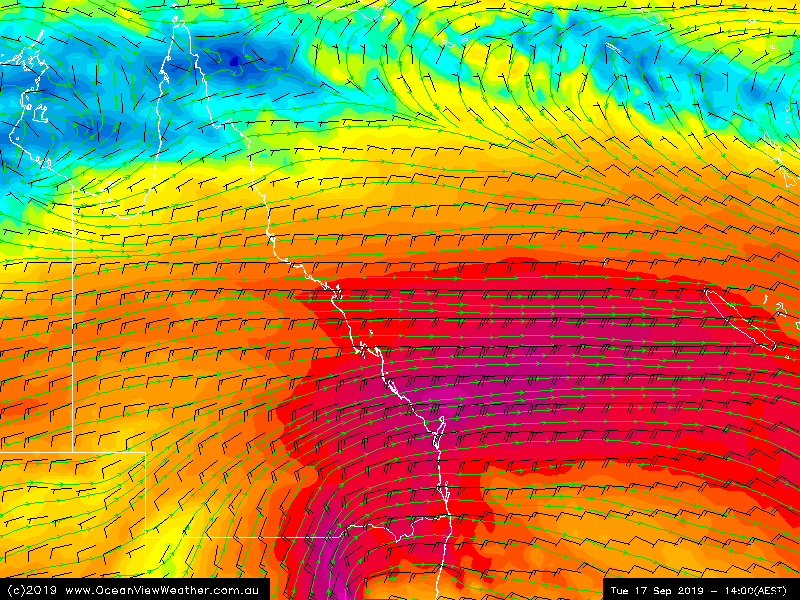 Edited by user Saturday, 14 September 2019 4:16:29 PM(UTC)
| Reason: Added 500hpa wind, because the colours look pretty!
|
4 users thanked Pabloako for this useful post.
|
|
|
|
Rank: Advanced Member
Groups: Registered
Joined: 7/09/2019(UTC) Posts: 67 Location: Brisbane Thanks: 113 times
Was thanked: 207 time(s) in 61 post(s)
|
Sadly fires are still burning in NSW this afternoon and show no sign of reducing. 
|
4 users thanked SatMan for this useful post.
|
|
|
|
Rank: Advanced Member
Groups: Registered
Joined: 25/08/2019(UTC) Posts: 1,839 Location: Ferny Grove Thanks: 985 times
Was thanked: 856 time(s) in 419 post(s)
|
|
|
3 users thanked Falling_Droplet for this useful post.
|
|
|
|
Rank: Advanced Member
Groups: Registered
Joined: 21/08/2019(UTC) Posts: 182 Location: Wynnum North Thanks: 656 times
Was thanked: 381 time(s) in 167 post(s)
|
WYNNUM NORTH ( 27.4S 153.2E ) - WEATHER
DATE....15 SEP 2019...TIME...0750
CURRENT TEMPERATURE...17.1C
CURRENT HUMIDITY........76%
CURRENT DEW POINT.......13C
CURRENT WIND DIR/SPEED..SSW 9Kph
CURRENT MSL PRESSURE...1025.9Hpa
CURRENT VISIBILITY.....10KM
CURRENT CLOUD..........1/8 Cu
CURRENT WEATHER......Smoke haze
RAIN SINCE 0900 SATURDAY..0.0mm
SUMMARY LAST 24 HOURS
YESTERDAY'S MAX TEMP. .......25.9C
THIS MORNING'S MIN TEMP......11.6C
PAST 24 HOURS TEMP ANOMALY..+0.15C
THIS MORNING'S GRASS MIN......8.9C
AVERAGE 24 HOUR DEW POINT......14C
AVERAGE 24 HOUR MSLP........1021.8Hpa
MAX WIND GUST LAST 24 HOURS..E 30Kph at 1820
PAST 24 HR SIGNIFICANT WEATHER..Smoke haze. |
Wyn Nth 2020-Jan165, |
2 users thanked retired weather man for this useful post.
|
|
|
|
Rank: Advanced Member
Groups: Registered
Joined: 23/08/2019(UTC) Posts: 155 Location: Narangba Thanks: 280 times
Was thanked: 442 time(s) in 136 post(s)
|
A smokey start to the day down here, but it just looks to be smoke from the NSW fires has drifted up and nothing local. Does it still look like we have a chance of a drop of rain on Tuesday?
|
2 users thanked CantSpellNarangba for this useful post.
|
|
|
|
Rank: Advanced Member
Groups: Registered, Administrators Joined: 21/08/2019(UTC) Posts: 941 Location: Brisbane Northside Thanks: 1198 times
Was thanked: 1136 time(s) in 674 post(s)
|
A bit of excitement on Friday for some residents on the Gold Coast. A water spout formed and picked up their 1.5 tonne boat in threw it into the water. Here is the full story of the water spout and BoM explaining the cause. Watch towards the end the tinnie getting picked up and swirled around. The main boat is 1.5 tonnes https://m.facebook.com/w...473581696817472&_rdrI can’t get the 1st link to work directly on this page so just click the link, it will take you to the 7 news and it is interesting . Changed link. Edited by user Sunday, 15 September 2019 10:17:58 AM(UTC)
| Reason: Changed link |
Colin Maitland. |
3 users thanked Colmait for this useful post.
|
|
|
|
Rank: Advanced Member
Groups: Registered
Joined: 25/08/2019(UTC) Posts: 1,839 Location: Ferny Grove Thanks: 985 times
Was thanked: 856 time(s) in 419 post(s)
|
Ferny Grove Weather
Date: 15 Sep 2019
Time: 8:25 AM
Min Temp since 9am yesterday: 12.2 C
Max Temp since 9am yesterday: 31.5 C
Min Ground Temp: 9.4 C
Rain since 9am yesterday: 0 mm
Temperature: 20.6 C
Relative Humidity: 56 %
Dew Point: 11.5 C
MSL Pressure: 1025.3 hPa
Wind Speed: light air
Wind Direction: NE
Present Weather: Haze
Visibility: 10km to 19km - Good Visibility
Cloud Cover: 1/8
Ground State: Ground dry
Notes of yesterday weather - 14/9/19: Fine. Smoke haze. A hot day. Moderately low dew point rising from early, rising quicker in the early morning to near average before falling from the mid morning and for a brief period in the late morning very quickly. The dew point became very low from the late morning and variable into the afternoon before sharply rising at 4pm to moderately low. In the late afternoon the dew point rose to near average and fell slightly in the early evening and slowly rose for the rest of the evening. Relative humidity fell very quickly from the early morning becoming very low later in the morning. The relative humidity was stabilised at 5 to 10 % and briefly 3 to 5 % in the afternoon before sharply rising from 4 pm close to average. At around 8pm there was brief fall in the relative humidity before resuming the normal rising of relative humidity. Light and variable winds at times early before winds varying between N to SSW (through W) from early morning with some ESE to NNE winds in the early morning. SSE to ENE winds wind change from 4 pm and light SSE to ESE winds in the evening.
Today: Smoke Haze. Dew point have been stable and near average. Temperature fell slowly overnight and was stable at times. Relative humidity have been near average and fall started to fall to moderately low. Light SE to ENE winds have developed in the last hour after some light and variable winds overnight.
|
|
1 user thanked Falling_Droplet for this useful post.
|
|
|
|
Weather Forum
»
Australia Weather
»
SEQ and NE NSW
»
SE QLD and NE NSW - Day to Day Weather
Forum Jump
You cannot post new topics in this forum.
You cannot reply to topics in this forum.
You cannot delete your posts in this forum.
You cannot edit your posts in this forum.
You cannot create polls in this forum.
You cannot vote in polls in this forum.
Important Information:
The Weather Forum uses cookies. By continuing to browse this site, you are agreeing to our use of cookies.
More Details
Close
