Weather Forum
»
Australia Weather
»
SEQ and NE NSW
»
SE QLD and NE NSW - Day to Day Weather
Rank: Advanced Member
Groups: Registered
Joined: 24/08/2019(UTC) Posts: 292  Location: Country Victorian Thanks: 580 times
Was thanked: 503 time(s) in 194 post(s)
|
|
 6 users thanked crikey for this useful post.
|
|
|
|
Rank: Advanced Member
Groups: Registered
Joined: 23/08/2019(UTC) Posts: 155 Location: Narangba Thanks: 280 times
Was thanked: 442 time(s) in 136 post(s)
|
It was a bit of a non descript kind of day today. Sunny-ish, cool-ish and a bit boring. Fingers crossed for the trough Crikey is mentioning helps bring us a few drops of rain.
|
5 users thanked CantSpellNarangba for this useful post.
|
|
|
|
Rank: Advanced Member
Groups: Registered
Joined: 25/08/2019(UTC) Posts: 1,839 Location: Ferny Grove Thanks: 985 times
Was thanked: 856 time(s) in 419 post(s)
|
|
|
4 users thanked Falling_Droplet for this useful post.
|
|
|
|
Rank: Advanced Member
Groups: Registered
Joined: 21/08/2019(UTC) Posts: 185 Location: Ocean View Thanks: 359 times
Was thanked: 539 time(s) in 161 post(s)
|
Visibility up here this morning is quite low due to the fires over on Stradbroke Island, with quite a strong smell outside.
|
5 users thanked Pabloako for this useful post.
|
|
|
|
Rank: Advanced Member
Groups: Registered
Joined: 21/08/2019(UTC) Posts: 182 Location: Wynnum North Thanks: 656 times
Was thanked: 381 time(s) in 167 post(s)
|
WYNNUM NORTH ( 27.4S 153.2E ) - WEATHER
DATE....20 SEP 2019...TIME...0740
CURRENT TEMPERATURE...18.1C
CURRENT HUMIDITY........81%
CURRENT DEW POINT.......15C
CURRENT WIND DIR/SPEED...NW 3kph
CURRENT VISIBILITY.....15KM
CURRENT CLOUD..........1/8 Cu
CURRENT WEATHER......Smoke haze
RAIN SINCE 0900 THURSDAY..0.0mm
SUMMARY LAST 24 HOURS
YESTERDAY'S MAX TEMP. .......24.7C
THIS MORNING'S MIN TEMP......12.4C
PAST 24 HOURS TEMP ANOMALY..-0.05C
THIS MORNING'S GRASS MIN.....12.1C
AVERAGE 24 HOUR DEW POINT......14C
AVERAGE 24 HOUR MSLP........1026.6Hpa
MAX WIND GUST LAST 24 HOURS....E 35Kph at 1437
PAST 24 HR SIGNIFICANT WEATHER..Smoke haze. |
Wyn Nth 2020-Jan165, |
2 users thanked retired weather man for this useful post.
|
|
|
|
Rank: Advanced Member
Groups: Registered
Joined: 24/08/2019(UTC) Posts: 292 Location: Country Victorian Thanks: 580 times
Was thanked: 503 time(s) in 194 post(s)
|
You may need to put your website link on your profile 'falling drop'. l couldn't find it?
could you post it here thanks
The mornings here at the tweed have continued to be cold.
The BOM obs' say coolongatta is 17 deg c at 7.30am
Brrr it feels colder than that. Dew point is a reasonable15 deg c , with a South Westerly.
I must be cold in the shade.
Can anyone with a weather station tell me the difference in temperature between in the sun and in the shade.??
It might be 17 here in the sun but it is brr cold in the shade. We got down to 11.2 deg c last night.
|
4 users thanked crikey for this useful post.
|
|
|
|
Rank: Advanced Member
Groups: Registered
Joined: 25/08/2019(UTC) Posts: 1,839 Location: Ferny Grove Thanks: 985 times
Was thanked: 856 time(s) in 419 post(s)
|
Ferny Grove Weather
Date: 20 Sep 2019
Time: 7:50 AM
Min Temp since 9am yesterday: 14.1 C
Max Temp since 9am yesterday: 26.8 C
Min Ground Temp: 12 C
Rain since 9am yesterday: 0 mm
Temperature: 19.3 C
Relative Humidity: 65 %
Dew Point: 12.5 C
MSL Pressure: 1026 hPa
Wind Speed: 3 kph - light air
Wind Direction: S
Present Weather: Haze
Visibility: 20km to 39km - Very Good Visibility
Cloud Cover: 1/8
Ground State: Ground dry
Notes of yesterday weather - 19/9/19: Moderately low dew point early, rising to near average in the early morning and remaining near average for the rest of the day. During the morning and in the evening the dew point fell slightly and rose in the afternoon. Light W to SW winds early at times, WNW to SSW in the early morning becoming S to SE, ENE to ESE from mid morning becoming calm in the evening.
Today: Minimum temperature occurred just after midnight with the temperature rising between 1 and 2 am and otherwise stable before warming with sunrise. Near average dew point but fluctuated a little and is currently rising. Relative humidity is close to average so far today. Light S to WSW winds and have been S to SE in the last 15 minutes.
|
|
4 users thanked Falling_Droplet for this useful post.
|
|
|
|
Rank: Advanced Member
Groups: Registered
Joined: 2/09/2019(UTC) Posts: 105 Location: Brisbane Thanks: 145 times
Was thanked: 561 time(s) in 103 post(s)
|
  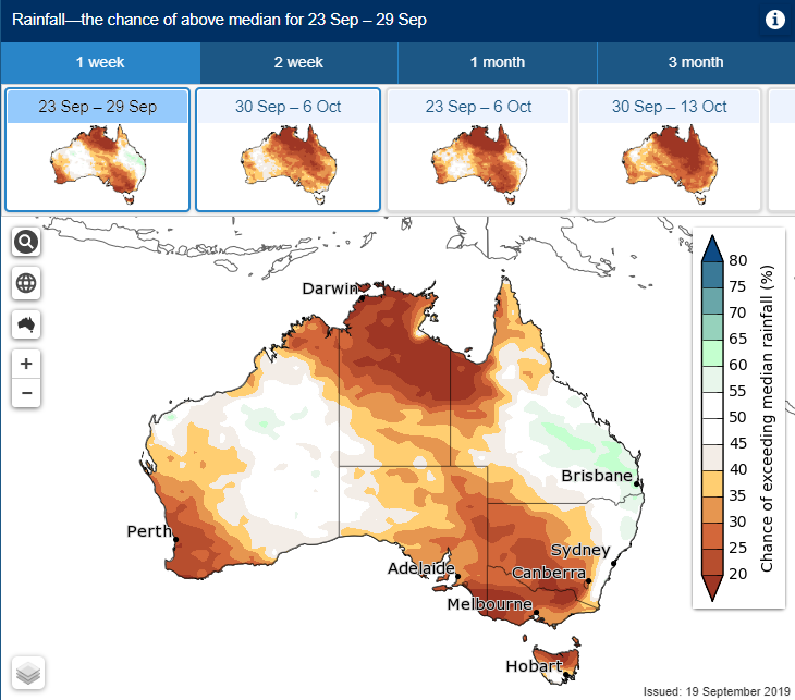 1st graphic above - some possible instability showing up again in about a week's time as the flow becomes more northerly again - these are the percentages of the GFS ensemble currently going for a combo of more than 500j/kg of CAPE and at least some measurable rainfall for Archerfield. 2nd image - a couple of periods of a bit of rainfall also currently showing up in the 10-day multimodel accumulated rainfall plume for Brisbane, mainly during the overnight hours tonight and again in around a week's time. 3rd image - the first time in awhile I've seen anything other than dark brown for this region on the multiweek ACCESS-S outputs. While the probabilities are almost 50/50, at least it's something. Temps also look like being pleasantly cool to mild locally for a change except for a brief hotter spike around Monday and warmer than normal min temps.
|
12 users thanked Ken for this useful post.
|
Falling_Droplet on 20/09/2019(UTC), southawk on 20/09/2019(UTC), i4hanish on 20/09/2019(UTC), Colmait on 20/09/2019(UTC), Paul Atkins on 20/09/2019(UTC), CantSpellNarangba on 20/09/2019(UTC), DelBoy on 20/09/2019(UTC), SatMan on 20/09/2019(UTC), Pabloako on 20/09/2019(UTC), NotCrocDundee on 21/09/2019(UTC), Slovenski on 21/09/2019(UTC), retired weather man on 22/09/2019(UTC)
|
|
|
Rank: Advanced Member
Groups: Registered
Joined: 25/08/2019(UTC) Posts: 1,839 Location: Ferny Grove Thanks: 985 times
Was thanked: 856 time(s) in 419 post(s)
|
Originally Posted by: crikey  You may need to put your website link on your profile 'falling drop'. l couldn't find it?
could you post it here thanks
The mornings here at the tweed have continued to be cold.
The BOM obs' say coolongatta is 17 deg c at 7.30am
Brrr it feels colder than that. Dew point is a reasonable15 deg c , with a South Westerly.
I must be cold in the shade.
Can anyone with a weather station tell me the difference in temperature between in the sun and in the shade.??
It might be 17 here in the sun but it is brr cold in the shade. We got down to 11.2 deg c last night.
I have the link in the signature of each post and in my profile. This is the link: Fernygroveweather.comTemperature is measured in the shade of a enclosure that is sited in sun. If you were to measure this in full shade you would have the objects producing the shade affect the exposure to the environment that you trying to measure and wouldn't be comparable between sites. What you are feeling is the effects that the humidity and wind has on how the temperature feels. The apparent temperature is one way that can be measured. |
|
5 users thanked Falling_Droplet for this useful post.
|
|
|
|
Rank: Advanced Member
Groups: Registered
Joined: 24/08/2019(UTC) Posts: 292 Location: Country Victorian Thanks: 580 times
Was thanked: 503 time(s) in 194 post(s)
|
Oh yes. I see that fernygrove link. thanks fallindrop
Thanks so much Ken for all that information you have posted. It is greatly appreciated.
Will look with interest at the developments.
Scrapping the barrel with ACC r.
I can see a weak precip signal on the border coastline .Just a small localized signal.
Tomorrow ,(saturday) about 4pm.
It seems to be on the boundary line between the Tasman high and incoming long wave trough.
The signal runs from the border coast , northward up to the sunshine coast.
Possible onshore activity tomorrow afternoon perhaps. Looking out for some onshore convective cumulus?
Any thoughts about the potential here form few mm?http://www.bom.gov.au/au...harts/viewer/index.shtml
|
7 users thanked crikey for this useful post.
|
|
|
|
Rank: Advanced Member
Groups: Registered
Joined: 23/08/2019(UTC) Posts: 155 Location: Narangba Thanks: 280 times
Was thanked: 442 time(s) in 136 post(s)
|
I got all excited when I saw WATL and GFS this morning for Wednesday next week. It has since been downgraded a HUGE amount. 
|
5 users thanked CantSpellNarangba for this useful post.
|
|
|
|
Rank: Advanced Member
Groups: Registered
Joined: 25/08/2019(UTC) Posts: 1,839 Location: Ferny Grove Thanks: 985 times
Was thanked: 856 time(s) in 419 post(s)
|
Today saw near average temperatures which fluctuated during the day due to cu cloud coverage. Dew point and relative humidity have been near average. Winds became light ESE to ENE, E to SE in the evening and is now calm. Edited by user Friday, 20 September 2019 10:05:20 PM(UTC)
| Reason: Not specified |
|
4 users thanked Falling_Droplet for this useful post.
|
|
|
|
Rank: Advanced Member
Groups: Registered
Joined: 21/08/2019(UTC) Posts: 185 Location: Ocean View Thanks: 359 times
Was thanked: 539 time(s) in 161 post(s)
|
Just as Ken's magical graph said, I have woken up to 1mm of rain from a couple of overnight showers and I am up in the clouds today, although they are slowly lifting. So nice to have some humidity back.
|
6 users thanked Pabloako for this useful post.
|
|
|
|
Rank: Advanced Member
Groups: Registered
Joined: 21/08/2019(UTC) Posts: 182 Location: Wynnum North Thanks: 656 times
Was thanked: 381 time(s) in 167 post(s)
|
WYNNUM NORTH ( 27.4S 153.2E ) - WEATHER
DATE....21 SEP 2019...TIME...0745
CURRENT TEMPERATURE...20.4C
CURRENT HUMIDITY........88%
CURRENT DEW POINT.......18C
CURRENT WIND DIR/SPEED...ESE 7kph
CURRENT VISIBILITY.....25KM
CURRENT CLOUD..........1/8 St, 4/8 Cu, 2/8 Ac, 2/8 Ci.
CURRENT WEATHER......Distant showers.
RAIN SINCE 0900 FRIDAY..2.0mm
SUMMARY LAST 24 HOURS
YESTERDAY'S MAX TEMP. .......25.1C
THIS MORNING'S MIN TEMP......15.7C
PAST 24 HOURS TEMP ANOMALY..+1.80C
THIS MORNING'S GRASS MIN.....13.9C
AVERAGE 24 HOUR DEW POINT......17C
AVERAGE 24 HOUR MSLP........1024.6Hpa
MAX WIND GUST LAST 24 HOURS....E 33Kph at 1440
PAST 24 HR SIGNIFICANT WEATHER..Smoke haze thinned during Friday. Early morning showers Saturday. |
Wyn Nth 2020-Jan165, |
5 users thanked retired weather man for this useful post.
|
|
|
|
Rank: Advanced Member
Groups: Registered
Joined: 24/08/2019(UTC) Posts: 292 Location: Country Victorian Thanks: 580 times
Was thanked: 503 time(s) in 194 post(s)
|
Cumulus cloud here at the Tweed .With dark grey bottoms.Just had a brief shower here. The radar showing a march of beefy onshore shower cells. A few of which are penetrating over the divide to Boonah. 
|
8 users thanked crikey for this useful post.
|
|
|
|
Rank: Advanced Member
Groups: Registered
Joined: 2/09/2019(UTC) Posts: 105 Location: Brisbane Thanks: 145 times
Was thanked: 561 time(s) in 103 post(s)
|
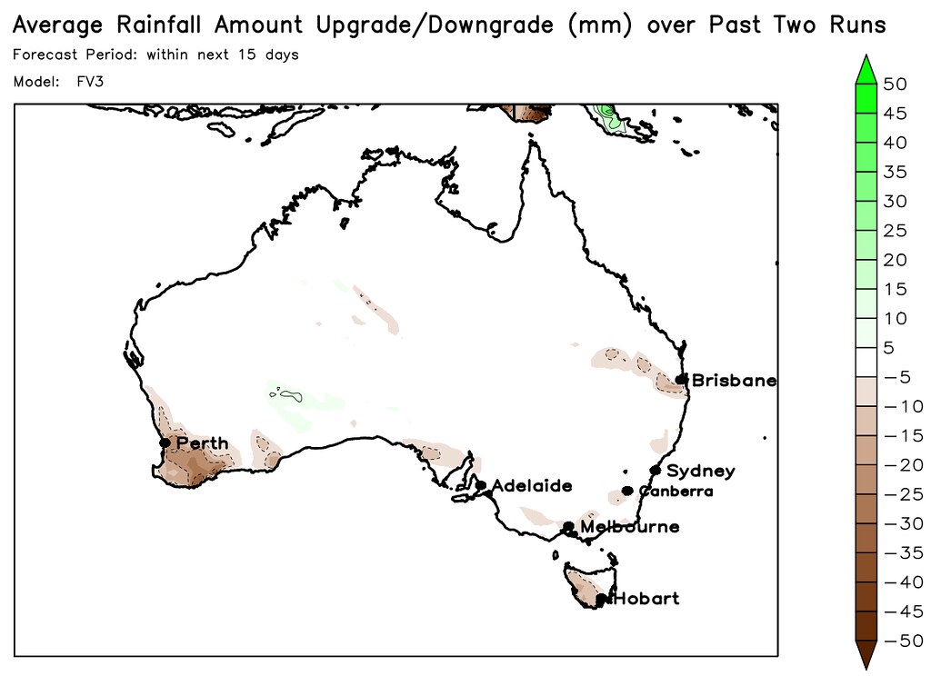 Above is a map showing the amount by which GFS has upgraded or downgraded its 15-day accumulated rainfall (forecast period starts from tomorrow). The amounts by which it's upgraded or downgraded are averaged over the past 2 runs (any more and the more accurate increasing/decreasing trends in the more recent runs tend to be masked by the ones in the older runs without a complex technique to overcome it.... any less and potential one-off erratic jumps in a single run tend to be a problem). Ideally I would've liked to have used whatever number of consecutive runs have consistently been going for an increasing or decreasing trend but it's very hard to do with the limitations of the GrADS programming language. It's designed to give an indication of which areas might hold more promise and which areas might turn out to be fizzers but the inherent problem with trying to extrapolate trends in consecutive model runs is that there's no guarantee that any upgrades or downgrades in recent runs will necessarily continue in future runs (sometimes they can even reverse).
|
8 users thanked Ken for this useful post.
|
|
|
|
Rank: Advanced Member
Groups: Registered
Joined: 25/08/2019(UTC) Posts: 1,839 Location: Ferny Grove Thanks: 985 times
Was thanked: 856 time(s) in 419 post(s)
|
Ferny Grove Weather
Date: 21 Sep 2019
Time: 10:00 AM
Min Temp since 9am yesterday: 15.7 C
Max Temp since 9am yesterday: 27.3 C
Min Ground Temp: 13.1 C
Rain since 9am yesterday: 0.2 mm
Temperature: 24.9 C
Relative Humidity: 53 %
Dew Point: 14.7 C
MSL Pressure: 1025.8 hPa
Wind Speed: light breeze
Wind Direction: E
Present Weather: State of sky generally unchanged during preceding hour
Visibility: 20km to 39km - Very Good Visibility
Cloud Cover: 5/8
Ground State: Ground dry
Notes of yesterday weather - 20/9/19: Fine. Sunny morning and partly cloudy from middle of the day with cu clouds developing from mid morning. Quite variable temperature later in the morning through to afternoon. Dew point was near average while being variable and fluctuating. Near average relative humidity and was variable from mid morning to late afternoon. Light WSW to SSW winds at times early becoming SSE to E in the morning and ESE to ENE later in the morning. In the afternoon winds were light ESE to ENE and in the evening was light E to SE winds becoming calm later in the evening.
Today: A few brief light showers during the early hours. Quite solid cu cloud development so far today. The temperature fell slowly in the early hours of today and rose at times, due to cloud coverage. Dew point have been rising slowly and rising and more quickly since 5:30 am, became moderately high but have since fallen to near average but is currently stable. Near average relative humidity. Calm winds with SW winds from 7:30 am and E to NE winds since 8am.
|
|
3 users thanked Falling_Droplet for this useful post.
|
|
|
|
Rank: Advanced Member
Groups: Registered
Joined: 21/09/2019(UTC) Posts: 32 Location: Gold coast Thanks: 125 times
Was thanked: 126 time(s) in 31 post(s)
|
Sounds like an interesting and challenging project you have going on there Ken. There is not exactly much in the forecast to downgrade anyway atm. So are the downgrades due to change in synoptic position or convective potential? or are you just looking at the trends of the model. Precipitation output only. I notice you have areas colored in. Does the program adjust area/location of precipitation as well? Thanks for sharing that. BTW The RACQ were on the radio this morning warning people to watch out for wildlife on the roads as recent rain had caused grass to grow on the verges of the roads Enjoying your posts and hope the forum takes off. 
|
4 users thanked juztchillin for this useful post.
|
|
|
|
Rank: Advanced Member
Groups: Registered
Joined: 21/08/2019(UTC) Posts: 185 Location: Ocean View Thanks: 359 times
Was thanked: 539 time(s) in 161 post(s)
|
Great images Ken. Thank you for sharing and keep them coming, because they are very informative.
I had a look at some charts yesterday and things seemed rather promising, however today isn't looking that was as much.
Also, big welcome JustChillin... Glad you could come and join our growing family of merry weather watchers!
|
2 users thanked Pabloako for this useful post.
|
|
|
|
Rank: Advanced Member
Groups: Registered
Joined: 7/09/2019(UTC) Posts: 67 Location: Brisbane Thanks: 113 times
Was thanked: 207 time(s) in 61 post(s)
|
Originally Posted by: Ken
Above is a map showing the amount by which GFS has upgraded or downgraded its 15-day accumulated rainfall (forecast period starts from tomorrow).
The amounts by which it's upgraded or downgraded are averaged over the past 2 runs (any more and the more accurate increasing/decreasing trends in the more recent runs tend to be masked by the ones in the older runs without a complex technique to overcome it.... any less and potential one-off erratic jumps in a single run tend to be a problem). Ideally I would've liked to have used whatever number of consecutive runs have consistently been going for an increasing or decreasing trend but it's very hard to do with the limitations of the GrADS programming language.
It's designed to give an indication of which areas might hold more promise and which areas might turn out to be fizzers but the inherent problem with trying to extrapolate trends in consecutive model runs is that there's no guarantee that any upgrades or downgrades in recent runs will necessarily continue in future runs (sometimes they can even reverse).
What a cracking idea Ken and a wonderful to get trending of forecasts on the run up to an event. I played with GrADS 20+ years ago and it was almost going back in time to my programming days back at Uni. It is a cracking language though and as I keep telling my wife, the old ones (like me) are the best!
|
4 users thanked SatMan for this useful post.
|
|
|
|
Weather Forum
»
Australia Weather
»
SEQ and NE NSW
»
SE QLD and NE NSW - Day to Day Weather
Forum Jump
You cannot post new topics in this forum.
You cannot reply to topics in this forum.
You cannot delete your posts in this forum.
You cannot edit your posts in this forum.
You cannot create polls in this forum.
You cannot vote in polls in this forum.
Important Information:
The Weather Forum uses cookies. By continuing to browse this site, you are agreeing to our use of cookies.
More Details
Close
