Weather Forum
»
Australia Weather
»
SEQ and NE NSW
»
SE QLD and NE NSW - Day to Day Weather
Rank: Advanced Member
Groups: Registered
Joined: 23/08/2019(UTC) Posts: 155  Location: Narangba Thanks: 280 times
Was thanked: 442 time(s) in 136 post(s)
|
Great image Ken and thank you for sharing with us.
|
 4 users thanked CantSpellNarangba for this useful post.
|
|
|
|
Rank: Advanced Member
Groups: Registered
Joined: 21/08/2019(UTC) Posts: 185 Location: Ocean View Thanks: 359 times
Was thanked: 539 time(s) in 161 post(s)
|
After a day of lower fire ratings, they are on their way back up early next week. 
|
4 users thanked Pabloako for this useful post.
|
|
|
|
Rank: Advanced Member
Groups: Registered
Joined: 13/09/2019(UTC)
Posts: 118
Location: Caboolture (the next Las Vegas!)
Thanks: 215 times
Was thanked: 297 time(s) in 100 post(s)
|
I had a job several years ago at QLD Government 'Natural Resources and Water' as it was known back then and I used to read the Long Paddock forecasts, because it was the time that Brisbane was in the drought. Anyway, I had completely forgotten about he site and suddenly remembered it the other day. It has improved quite a bit since then and is a lot more readable now! Here is the link to the Monthly Summary for September and they are not painting a dire forecast, however it is a long range forecast, so I guess it may change. https://data.longpaddock.qld.gov.au/MonthlyClimateStatements/DES-Monthly-Climate-Statement_Sep2019.pdfAs a brief snippet: 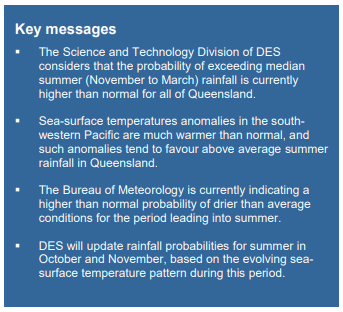 
|
4 users thanked DelBoy for this useful post.
|
|
|
|
Rank: Advanced Member
Groups: Registered
Joined: 2/09/2019(UTC) Posts: 105 Location: Brisbane Thanks: 145 times
Was thanked: 561 time(s) in 103 post(s)
|
Originally Posted by: DelBoy  I had a job several years ago at QLD Government 'Natural Resources and Water' as it was known back then and I used to read the Long Paddock forecasts, because it was the time that Brisbane was in the drought. Anyway, I had completely forgotten about he site and suddenly remembered it the other day. It has improved quite a bit since then and is a lot more readable now! Here is the link to the Monthly Summary for September and they are not painting a dire forecast, however it is a long range forecast, so I guess it may change. https://data.longpaddock.qld.gov.au/MonthlyClimateStatements/DES-Monthly-Climate-Statement_Sep2019.pdfAs a brief snippet: The long paddock's outlooks based on the correlations between sea surface temperature patterns and rainfall, sometimes makes for an interesting contrast to the Bureau's outlooks which use a dynamical model.
|
4 users thanked Ken for this useful post.
|
|
|
|
Rank: Advanced Member
Groups: Registered
Joined: 13/09/2019(UTC)
Posts: 118
Location: Caboolture (the next Las Vegas!)
Thanks: 215 times
Was thanked: 297 time(s) in 100 post(s)
|
Originally Posted by: Ken
The long paddock's outlooks based on the correlations between sea surface temperature patterns and rainfall, sometimes makes for an interesting contrast to the Bureau's outlooks which use a dynamical model.
Obviously BOM's forecast are generated by meteorologists and pretty beefy computers in Aus and overseas etc... Are DES (Long Paddock) people meteorologists too?
|
3 users thanked DelBoy for this useful post.
|
|
|
|
Rank: Advanced Member
Groups: Registered
Joined: 2/09/2019(UTC) Posts: 105 Location: Brisbane Thanks: 145 times
Was thanked: 561 time(s) in 103 post(s)
|
Originally Posted by: DelBoy Originally Posted by: Ken
The long paddock's outlooks based on the correlations between sea surface temperature patterns and rainfall, sometimes makes for an interesting contrast to the Bureau's outlooks which use a dynamical model.
Obviously BOM's forecast are generated by meteorologists and pretty beefy computers in Aus and overseas etc... Are DES (Long Paddock) people meteorologists too? Nah the Bureau's maps are generated automatically by the ACCESS-S model with no human intervention (except for the accompanying text narratives). I'm not sure about DES's maps but I suspect the main guidance they use from the SST/rainfall correlations is also automatically generated... I'm not sure if there's manual intervention after that.
|
3 users thanked Ken for this useful post.
|
|
|
|
Rank: Advanced Member
Groups: Registered
Joined: 3/09/2019(UTC) Posts: 51 Location: gladstone Thanks: 108 times
Was thanked: 50 time(s) in 26 post(s)
|
Originally Posted by: DelBoy I had a job several years ago at QLD Government 'Natural Resources and Water' as it was known back then and I used to read the Long Paddock forecasts, because it was the time that Brisbane was in the drought. Anyway, I had completely forgotten about he site and suddenly remembered it the other day. It has improved quite a bit since then and is a lot more readable now! Here is the link to the Monthly Summary for September and they are not painting a dire forecast, however it is a long range forecast, so I guess it may change. https://data.longpaddock.qld.gov.au/MonthlyClimateStatements/DES-Monthly-Climate-Statement_Sep2019.pdfAs a brief snippet: Good find delboy.I just love the look of those blue colors for summer. Bring it on.! 
|
3 users thanked oceangyre for this useful post.
|
|
|
|
Rank: Advanced Member
Groups: Registered
Joined: 13/09/2019(UTC)
Posts: 118
Location: Caboolture (the next Las Vegas!)
Thanks: 215 times
Was thanked: 297 time(s) in 100 post(s)
|
I feel sorry for farmers! BOM saying one thing and QLD Gov potentially saying another thing.
|
2 users thanked DelBoy for this useful post.
|
|
|
|
Rank: Advanced Member
Groups: Registered
Joined: 25/08/2019(UTC) Posts: 1,839 Location: Ferny Grove Thanks: 985 times
Was thanked: 856 time(s) in 419 post(s)
|
Decent cu cloud development didn't bring further showers before the clouds eased in the afternoon. Near average temperature today, though fluctuated with the passing cu clouds, settling in the afternoon. Dew point and relative humidity have been variable but near average. Light E to NE winds, NNE to NE in the evening and now is calm. |
|
4 users thanked Falling_Droplet for this useful post.
|
|
|
|
Rank: Advanced Member
Groups: Registered
Joined: 21/08/2019(UTC) Posts: 182 Location: Wynnum North Thanks: 656 times
Was thanked: 381 time(s) in 167 post(s)
|
WYNNUM NORTH ( 27.4S 153.2E ) - WEATHER
DATE....22 SEP 2019...TIME...0745
CURRENT TEMPERATURE...20.9C
CURRENT HUMIDITY........90%
CURRENT DEW POINT.......19C
CURRENT WIND DIR/SPEED...NNW 9kph
CURRENT VISIBILITY.....15KM
CURRENT MSL PRESSURE...1026.4Hpa
CURRENT CLOUD..........1/8 St, 3/8 Cu, 3/8 Sc.
CURRENT WEATHER......Local showers, but not at station..
RAIN SINCE 0900 SATURDAY..5.4mm
SUMMARY LAST 24 HOURS
YESTERDAY'S MAX TEMP. .......25.8C
THIS MORNING'S MIN TEMP......17.3C
PAST 24 HOURS TEMP ANOMALY..+2.95C
THIS MORNING'S GRASS MIN.....16.4C
AVERAGE 24 HOUR DEW POINT......18C
AVERAGE 24 HOUR MSLP........1024.6Hpa
MAX WIND GUST LAST 24 HOURS....E 34Kph at 1215
PAST 24 HR SIGNIFICANT WEATHER..Overnight and early morning showers. |
Wyn Nth 2020-Jan165, |
4 users thanked retired weather man for this useful post.
|
|
|
|
Rank: Advanced Member
Groups: Registered
Joined: 24/08/2019(UTC) Posts: 292 Location: Country Victorian Thanks: 580 times
Was thanked: 503 time(s) in 194 post(s)
|
We have a trough and cold front coming through today
ACC r has a weak precipitation signal.
over the NE NSW area and maybe encroaching a tad over the border
Nothing appearing on the BOM forecast. max 25 and a 20% chance of rain at the Tweed
Chance of a storm re higher dew points, moisture , temps and forcing?
|
7 users thanked crikey for this useful post.
|
|
|
|
Rank: Advanced Member
Groups: Registered
Joined: 2/09/2019(UTC) Posts: 105 Location: Brisbane Thanks: 145 times
Was thanked: 561 time(s) in 103 post(s)
|
Originally Posted by: crikey We have a trough and cold front coming through today
ACC r has a weak precipitation signal.
over the NE NSW area and maybe encroaching a tad over the border
Nothing appearing on the BOM forecast. max 25 and a 20% chance of rain at the Tweed
Chance of a storm re higher dew points, moisture , temps and forcing? I'd say the majority of any thunderstorm activity today will probably be confined to the zone between southern parts of the Mid North Coast of NSW and the Hunter/central coast as well as the adjacent inland.
|
8 users thanked Ken for this useful post.
|
|
|
|
Rank: Advanced Member
Groups: Registered
Joined: 25/08/2019(UTC) Posts: 1,839 Location: Ferny Grove Thanks: 985 times
Was thanked: 856 time(s) in 419 post(s)
|
Ferny Grove Weather
Date: 22 Sep 2019
Time: 10:10 AM
Min Temp since 9am yesterday: 14.7 C
Max Temp since 9am yesterday: 27.2 C
Min Ground Temp: 12.8 C
Rain since 9am yesterday: 0 mm
Temperature: 24.3 C
Relative Humidity: 54 %
Dew Point: 14.4 C
MSL Pressure: 1025.3 hPa
Wind Speed: 12 kph - gentle breeze
Wind Direction: N
Present Weather: State of sky generally unchanged during preceding hour
Visibility: 40km or more - Excellent Visibility
Cloud Cover: 3/8
Ground State: Ground dry
Notes of yesterday weather - 21/9/19: Fine. Partly cloudy with cu clouds during the morning, easing in the afternoon. Near average temperatures and was variable from mid morning to mid afternoon. In the late evening the dew point rose. Dew point rose during the early hours and became moderately high in the early morning before returning to near average from the mid morning and which was variable at times. Near average relative humidity and was variable in the late morning and afternoon. Light SW winds in the early morning became E to NE from early morning, and NNW to NE at times in the evening.
Today: Fine and a warm morning. The temperature have been a bit variable with cu clouds so far today. Dew point have been close to average which rose earlier this morning and have since fallen a bit. Near average overnight relative humidity and has fell reasonably quickly this morning. Some NNW winds in the early hours and NNW to NW since 8 am.
|
|
6 users thanked Falling_Droplet for this useful post.
|
|
|
|
Rank: Advanced Member
Groups: Registered
Joined: 7/09/2019(UTC) Posts: 67 Location: Brisbane Thanks: 113 times
Was thanked: 207 time(s) in 61 post(s)
|
A slightly breeze day today, with a few cumulus clouds floating by. 
|
6 users thanked SatMan for this useful post.
|
|
|
|
Rank: Advanced Member
Groups: Registered
Joined: 23/08/2019(UTC) Posts: 155 Location: Narangba Thanks: 280 times
Was thanked: 442 time(s) in 136 post(s)
|
BOM have now started adding the T word to some of their forecasts for late next week for Brissy...
Friday
Partly cloudy. Medium (50%) chance of showers. The chance of a thunderstorm in the west later in the day. Winds northwest to northeasterly and light increasing to 15 to 20 km/h during the day.
Saturday
Partly cloudy. Medium (50%) chance of showers. The chance of a thunderstorm in the west. Light winds
|
6 users thanked CantSpellNarangba for this useful post.
|
|
|
|
Rank: Advanced Member
Groups: Registered
Joined: 21/09/2019(UTC) Posts: 32 Location: Gold coast Thanks: 125 times
Was thanked: 126 time(s) in 31 post(s)
|
Nice to log in to the forum and have something to read  Beautiful weather on the coast today. Some dark bottomed clouds gave Palm beach and Surfers a few showers and then quickly cleared. No signs of any cold front or trough here.Or was that it this morning? A nice picture . I took today Morning cloud and showers ,Tallebudgera .,Followed by glorious sky , Nth Surfera Paradise.The contrast is amazing MORNING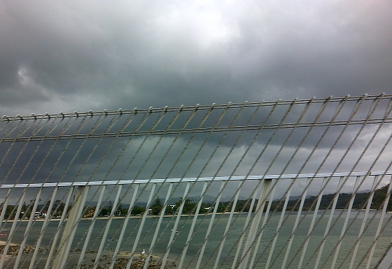 LUNCH LUNCH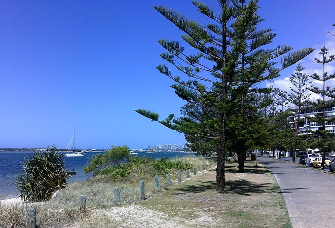
|
7 users thanked juztchillin for this useful post.
|
|
|
|
Rank: Advanced Member
Groups: Registered
Joined: 7/09/2019(UTC) Posts: 67 Location: Brisbane Thanks: 113 times
Was thanked: 207 time(s) in 61 post(s)
|
Hi JuztChillin and welcome to our happy family and lovely photographs. What a great part of the world you are in and look at that wondeful blue sky in you second picture.
Slip, slop, slap!
|
4 users thanked SatMan for this useful post.
|
|
|
|
Rank: Advanced Member
Groups: Registered
Joined: 23/08/2019(UTC) Posts: 155 Location: Narangba Thanks: 280 times
Was thanked: 442 time(s) in 136 post(s)
|
Hi Chillin and glad you could join us.
A lovely afternoon here too, now that the clouds have drifted away and the wind has droppee. A warm day ahead tomorrow and hopefully a drop of rain next week and a rumble or two later on in the week. I love this time of year..
|
3 users thanked CantSpellNarangba for this useful post.
|
|
|
|
Rank: Advanced Member
Groups: Registered, Administrators Joined: 21/08/2019(UTC) Posts: 941 Location: Brisbane Northside Thanks: 1198 times
Was thanked: 1136 time(s) in 674 post(s)
|
The T word is a bit all over the place ATM for Brisbane. Just using the basics you can see there is no agreement with the models but still it is over 5-6 days off. Still a chance though although not a real stand out “yeah” one yet. Maybe we have to send Ken on holiday again.  GFS isn’t showing much interest, so just posting figures 1 & 2 the LI’s and forecast sounding from this afternoon run for 16:00 Sat. Arvo which had the best chance. Very coastal at this point. I will just post those 2 charts I have the sheer etc but will wait until we get closer and hopefully things will improve.  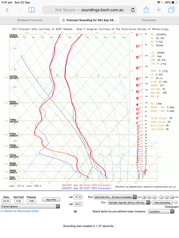 Now Meteye is happy as Larry the Lizard and showing a widespread chance for Saturday and couple of other days too. Figure 3 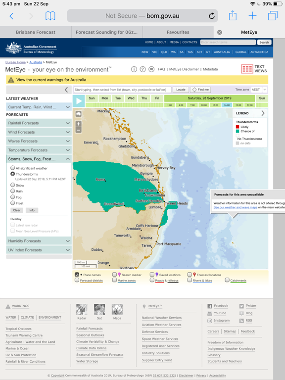 And EC, will it is showing storms around 03:00 Sunday morning. Sounding included. Figures 4 & 5 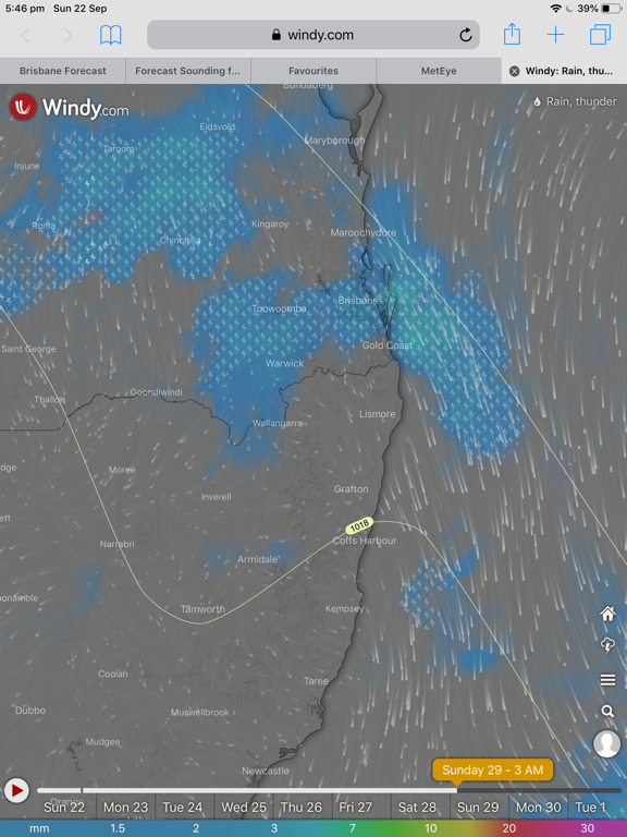 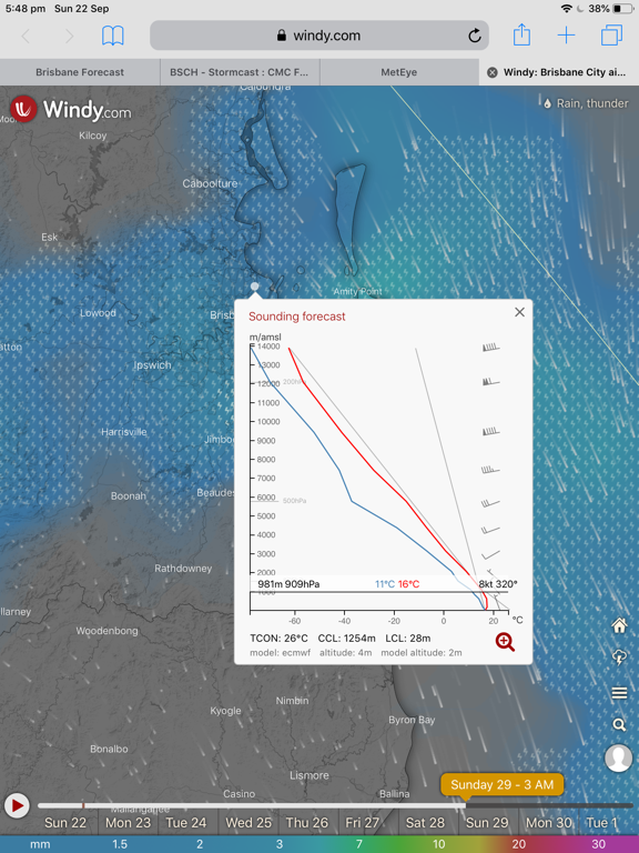 Just have to see how it unfolds as we draw closer. We are all storm deprived. Winter deprived and rain deprived. But I think we have had enough of the heat though. Cheers Colin   |
Colin Maitland. |
5 users thanked Colmait for this useful post.
|
|
|
|
Rank: Advanced Member
Groups: Registered
Joined: 23/08/2019(UTC) Posts: 155 Location: Narangba Thanks: 280 times
Was thanked: 442 time(s) in 136 post(s)
|
Cracking summary Colin. Thanks for putting it together.
Fingers crossed for later this week.
|
3 users thanked CantSpellNarangba for this useful post.
|
|
|
|
Weather Forum
»
Australia Weather
»
SEQ and NE NSW
»
SE QLD and NE NSW - Day to Day Weather
Forum Jump
You cannot post new topics in this forum.
You cannot reply to topics in this forum.
You cannot delete your posts in this forum.
You cannot edit your posts in this forum.
You cannot create polls in this forum.
You cannot vote in polls in this forum.
Important Information:
The Weather Forum uses cookies. By continuing to browse this site, you are agreeing to our use of cookies.
More Details
Close
