Weather Forum
»
Australia Weather
»
SEQ and NE NSW
»
SE QLD and NE NSW - Day to Day Weather
Rank: Advanced Member
Groups: Registered
Joined: 27/08/2019(UTC) Posts: 47  Location: Bayside Thanks: 51 times
Was thanked: 104 time(s) in 35 post(s)
|
Can someone tell me the firast streght of the jet stream between australia and nz for this saturday
|
|
|
|
|
|
Rank: Advanced Member
Groups: Registered, Administrators Joined: 21/08/2019(UTC) Posts: 941 Location: Brisbane Northside Thanks: 1198 times
Was thanked: 1136 time(s) in 674 post(s)
|
Originally Posted by: Tsunami  Can someone tell me the firast streght of the jet stream between australia and nz for this saturday http://www.stormsurfing....splay_alt.cgi?a=glob_250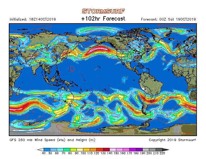 Between 70- 90 knots. Most models are in agreement. Depends which way you are going. To or from. |
Colin Maitland. |
 6 users thanked Colmait for this useful post.
|
|
|
|
Rank: Advanced Member
Groups: Registered
Joined: 25/08/2019(UTC) Posts: 1,839 Location: Ferny Grove Thanks: 985 times
Was thanked: 856 time(s) in 419 post(s)
|
Today the dew point rose in the morning, became briefly moderately high (19 C) in the morning before dropping back this afternoon while remaining near average. Quite variable and near average temperature during today in partly cloudy skies. Near average relative humidity. Light E to NNE winds today, ESE to NE later in the afternoon and E to NE this evening. |
|
3 users thanked Falling_Droplet for this useful post.
|
|
|
|
Rank: Advanced Member
Groups: Registered
Joined: 21/08/2019(UTC) Posts: 182 Location: Wynnum North Thanks: 656 times
Was thanked: 381 time(s) in 167 post(s)
|
WYNNUM NORTH ( 27.4S 153.2E ) - WEATHER
DATE....16 OCT 2019 TIME....0730
CURRENT TEMPERATURE...21.3C
CURRENT HUMIDITY........88%
CURRENT DEW POINT.......19C
CURRENT WIND DIR/SPEED...NW 6Kph
CURRENT VISIBILITY.....25KM
CURRENT MSL PRESSURE...1016.6Hpa
CURRENT CLOUD..........7/8 Sc.
CURRENT WEATHER......Smoke haze
RAIN SINCE 0900 TUESDAY...0.0mm
SUMMARY LAST 24 HOURS
YESTERDAY'S MAX TEMP. .......25.9C
THIS MORNING'S MIN TEMP......17.5C
PAST 24 HOURS TEMP ANOMALY..+0.80C
THIS MORNING'S GRASS MIN.....17.0C
AVERAGE 24 HOUR DEW POINT......19C
AVERAGE 24 HOUR MSLP........1013.9Hpa
MAX WIND GUST LAST 24 HOURS....E 45Kph at 1510
PAST 24 HR SIGNIFICANT WEATHER...Smoke haze developed. |
Wyn Nth 2020-Jan165, |
3 users thanked retired weather man for this useful post.
|
|
|
|
Rank: Advanced Member
Groups: Registered
Joined: 25/08/2019(UTC) Posts: 1,839 Location: Ferny Grove Thanks: 985 times
Was thanked: 856 time(s) in 419 post(s)
|
Ferny Grove Weather
Date: 16 Oct 2019
Time: 7:40 AM
Min Temp since 9am yesterday: 17.1 C
Max Temp since 9am yesterday: 28.7 C
Min Ground Temp: 15.3 C
Rain since 9am yesterday: 0.1 mm
Temperature: 21.1 C
Relative Humidity: 85 %
Dew Point: 18.5 C
MSL Pressure: 1016.3 hPa
Wind Speed: Calm
Wind Direction: Calm
Present Weather: State of sky generally unchanged during preceding hour
Visibility: 20km
Cloud Cover: 8/8
Ground State: Ground moist
Thunder yesterday: Yes
Notes of yesterday weather - 15/10/19: Cloudy with cu and as clouds, partly cloudy with cu clouds from late morning. Light showers and mild thunderstorm in the early hours with light to moderate falls clearing in the early morning. A cool morning and variable temperature in the morning and afternoon. Smoke haze. Near average dew point rose from early in the day, before generally falling in the afternoon and stable from the late afternoon. In the late morning the dew point became briefly moderately high. Light and variable winds early mostly W to SSW and N to NE, calm between 5am and 8am, ENE to NNE from am ESE to NE from late morning, ENE to NNE from late afternoon and ENE to NE later in the evening.
Today: A warm morning. Dew point have been near average and have been rising in the last few hours and is almost moderately high. Near average relative humidity. Light N to NE winds becoming calm in the early hours and ENE to NNE in the last 20 minutes.
|
|
2 users thanked Falling_Droplet for this useful post.
|
|
|
|
Rank: Advanced Member
Groups: Registered
Joined: 26/08/2019(UTC) Posts: 32 Location: Bardon Thanks: 96 times
Was thanked: 138 time(s) in 32 post(s)
|
From the BOM Twitter feed - thunderstorm forecast for 17/10/19. Hopefully we might get something - Greg 
|
4 users thanked Greg for this useful post.
|
|
|
|
Rank: Advanced Member
Groups: Registered
Joined: 2/09/2019(UTC) Posts: 105 Location: Brisbane Thanks: 145 times
Was thanked: 561 time(s) in 103 post(s)
|
I think many things look favourable on Thursday including the shear conducive for severe storms and the strong steering winds aloft although not everything's ideal.
For example, I'd rather the midlevels be colder (but if surface heating is intense enough, there should still be enough instability for storms), capping along some parts of the coast, and the NW to W component to the flow through a deep slab of the atmosphere. The southerly change pushing up the NSW coast shouldn't play a major role for SE QLD, given it's not due to reach this region until early Friday morning.
One of the many favourable things though is the fact that the stronger part of the upper trough will stay south which means there's a lower risk of prolonged extensive cloud cover and rainfall lasting through the whole morning and inhibiting storms.
While overall rainfall amounts look pretty modest as far as our own region goes (especially due to the speed of any showers and storms), there could be some lucky places which get higher amounts if they get under any of the heavier activity.
So here's how I think Thursday will play out:
1️⃣ Overnight tonight/very early Thu morning could see some additional localised activity moving across inland areas near the QLD/NSW border as well as the northern tablelands and some parts of the MNC coast.
2️⃣ While early morning may see some cloud cover over parts of SE QLD, models suggest much of this may decrease later in the morning.
3️⃣ Mostly sunny hot weather then dominating with daytime max temps rising to a number of degrees above the October average (but the coastal fringe should stay a lot cooler than inland).
4️⃣ Strong northerly winds developing along QLD's southern coastal fringe & islands... as well as strong westerlies along the Great Dividing Range from VIC, through NSW (where they could even be locally damaging), and to the southeastern Darling Downs in QLD in the wake of the approaching front.
5️⃣ During the middle of the day, a band of low-rainfall showers & storms starts firing up over the central and southeastern interior of QLD as well as inland NE NSW. This band then steadily marches eastwards, possibly as a squall line, towards the southern QLD coast.
The strong shear also means that some locations could also get a severe storm with brief damaging winds or large hail (moreso for any individual storms separate from any squall line).
NE NSW is also a bit complicated where the further south you go, the earlier the drier W to NW flow breaks through to the coast and therefore, the lower the chance of storms.
6️⃣ Later in the afternoon or early evening looks to be the make or break time as far as the coast goes.
Inland locations look an almost certainty and the coast also looks a reasonable chance - but the latter zone looks like one of those setups where there's a fine line between the strong steering winds aloft dragging the activity to the entire SE QLD coast (and even intensifying/growing there after eroding any capping and ingesting the higher surface dewpoint air in the northerly flow as well as interacting with a bit of a seabreeze front).... or weakening in the capped environment. Either scenario looks possible (I'd probably favour the activity reaching the coast but I'm not 100% certain yet).
|
5 users thanked Ken for this useful post.
|
|
|
|
Rank: Advanced Member
Groups: Registered
Joined: 25/08/2019(UTC) Posts: 1,839 Location: Ferny Grove Thanks: 985 times
Was thanked: 856 time(s) in 419 post(s)
|
A warm day today. The dew point rose this morning and became moderately low reaching 20 C, before falling since the late morning but was stable during the middle of the day. Currently the dew point is near average at 15 C. Near average relative humidity today. Light N to ENE winds, E to NE from late morning and N to NE tonight. Last 24 hours: |
|
2 users thanked Falling_Droplet for this useful post.
|
|
|
|
Rank: Advanced Member
Groups: Registered
Joined: 27/08/2019(UTC) Posts: 47 Location: Bayside Thanks: 51 times
Was thanked: 104 time(s) in 35 post(s)
|
Thanks Ken
Was about to ask of thoughts on todays set up
|
2 users thanked Tsunami for this useful post.
|
|
|
|
Rank: Advanced Member
Groups: Registered
Joined: 21/08/2019(UTC) Posts: 182 Location: Wynnum North Thanks: 656 times
Was thanked: 381 time(s) in 167 post(s)
|
WYNNUM NORTH ( 27.4S 153.2E ) - WEATHER
DATE....17 OCT 2019 TIME....0740
CURRENT TEMPERATURE...23.3C
CURRENT HUMIDITY........80%
CURRENT DEW POINT.......19C
CURRENT WIND DIR/SPEED...NNE 20Kph
CURRENT VISIBILITY.....25KM
CURRENT MSL PRESSURE...1014.7Hpa
CURRENT CLOUD..........6/8 Ac.
CURRENT WEATHER......Smoke haze
RAIN SINCE 0900 WEDNESDAY...0.0mm
SUMMARY LAST 24 HOURS
YESTERDAY'S MAX TEMP. .......27.6C
THIS MORNING'S MIN TEMP......20.0C
PAST 24 HOURS TEMP ANOMALY..+2.90C
THIS MORNING'S GRASS MIN.....18.1C
AVERAGE 24 HOUR DEW POINT......20C
AVERAGE 24 HOUR MSLP........1014.5Hpa
MAX WIND GUST LAST 24 HOURS....N 50Kph at 1916
PAST 24 HR SIGNIFICANT WEATHER...Smoke haze. |
Wyn Nth 2020-Jan165, |
3 users thanked retired weather man for this useful post.
|
|
|
|
Rank: Advanced Member
Groups: Registered
Joined: 25/08/2019(UTC) Posts: 1,839 Location: Ferny Grove Thanks: 985 times
Was thanked: 856 time(s) in 419 post(s)
|
Ferny Grove Weather
Date: 17 Oct 2019
Time: 7:40 AM
Min Temp since 9am yesterday: 17.6 C
Max Temp since 9am yesterday: 31.1 C
Min Ground Temp: 16.4 C
Rain since 9am yesterday: 0 mm
Temperature: 22.3 C
Relative Humidity: 70 %
Dew Point: 16.6 C
MSL Pressure: 1014 hPa
Wind Speed: 11 kph - light breeze
Wind Direction: NNE
Present Weather: Clouds generally dissolving or becoming less developed during the preceding hour
Visibility: 20km to 39km - Very Good Visibility
Cloud Cover: 3/8
Ground State: Ground dry
Notes of yesterday weather - 16/10/19: Cloudy with sc clouds early, partly cloudy with cu clouds from late morning and clearing in the afternoon. Smoke haze. A warm morning and a warm day. The dew point was stable and fell in the early hours before rising during the morning and became moderately high in the mid morning before falling back to near average in the late morning. After stabilising in the middle of the day the dew point rose slowly in the early afternoon and then fell during the afternoon and evening whilst remaining near average. Light N to NE winds very early in the day before becoming calm followed by constant N to ENE winds from early morning, E to NE from late morning and N to NE winds in the evening.
Today: Near average dew point have been stable and have started to rise. Light and variable winds at times early today and light N to NE in the last 2 hours.
|
|
2 users thanked Falling_Droplet for this useful post.
|
|
|
|
Rank: Advanced Member
Groups: Registered
Joined: 2/09/2019(UTC) Posts: 105 Location: Brisbane Thanks: 145 times
Was thanked: 561 time(s) in 103 post(s)
|
 Above is a chance of any (measurable) rainfall map for between 10am and 10pm today generated by the percentages of all the members of the US Navy ensemble and past 6 runs of GFS that are forecasting precip. You can see the general NW-SE oriented band of higher probabilities running down across the interior towards the southeast. Even though a number of the storms may be dry storms, I still find probability of precip a good proxy for flagging areas for potential showers/storms, and some lucky places may get some decent falls if they can get directly under a cell. Of course there may be some locations which hardly get anything even in the higher probability areas but that's the nature of showers/storms.
|
4 users thanked Ken for this useful post.
|
|
|
|
Rank: Member
Groups: Registered
Joined: 20/08/2019(UTC) Posts: 25 Location: Mooloolaba Thanks: 227 times
Was thanked: 110 time(s) in 24 post(s)
|
Looks like things are starting to fire up out west on 512km radar. Very warm here today and quite windy all day. Hoping for a bit of action later.
|
2 users thanked sharjay for this useful post.
|
|
|
|
Rank: Advanced Member
Groups: Registered
Joined: 27/08/2019(UTC) Posts: 47 Location: Bayside Thanks: 51 times
Was thanked: 104 time(s) in 35 post(s)
|
Wow that northerly is fair blowing
Gusts over 50km/h
Be nice if that feeds moisture
|
3 users thanked Tsunami for this useful post.
|
|
|
|
Rank: Member
Groups: Registered
Joined: 20/08/2019(UTC) Posts: 25 Location: Mooloolaba Thanks: 227 times
Was thanked: 110 time(s) in 24 post(s)
|
Originally Posted by: Tsunami Wow that northerly is fair blowing
Gusts over 50km/h
Be nice if that feeds moisture Been quite strong here on the Sunny Coast since earlier this morning when i woke. Will it help or hinder today's chances?
|
2 users thanked sharjay for this useful post.
|
|
|
|
Rank: Advanced Member
Groups: Registered
Joined: 26/08/2019(UTC) Posts: 32 Location: Bardon Thanks: 96 times
Was thanked: 138 time(s) in 32 post(s)
|
Nice view of the back end of the storm out near Roma as the storm moves away to the east. Roma Airport Sky cam
|
3 users thanked Greg for this useful post.
|
|
|
|
Rank: Advanced Member
Groups: Registered
Joined: 25/08/2019(UTC) Posts: 1,839 Location: Ferny Grove Thanks: 985 times
Was thanked: 856 time(s) in 419 post(s)
|
It has been warming a fair bit today and has reached 32 C and rose quite steadily. Dew point have been stable at 15 C. Light winds and almost moderate from N to NE have become E to SE since later in the morning. |
|
2 users thanked Falling_Droplet for this useful post.
|
|
|
|
Rank: Advanced Member
Groups: Registered
Joined: 27/08/2019(UTC) Posts: 47 Location: Bayside Thanks: 51 times
Was thanked: 104 time(s) in 35 post(s)
|
Gezz the 512km radar showing a good line heading for the coast
|
1 user thanked Tsunami for this useful post.
|
|
|
|
Rank: Advanced Member
Groups: Registered
Joined: 25/08/2019(UTC) Posts: 1,839 Location: Ferny Grove Thanks: 985 times
Was thanked: 856 time(s) in 419 post(s)
|
The temperature have started to fall along with a brief increase in dew point while remaining near average. Breezy E to NE winds have continued. Clouds building well to the west viewed from Brisbane. |
|
1 user thanked Falling_Droplet for this useful post.
|
|
|
|
Rank: Member
Groups: Registered
Joined: 20/08/2019(UTC) Posts: 25 Location: Mooloolaba Thanks: 227 times
Was thanked: 110 time(s) in 24 post(s)
|
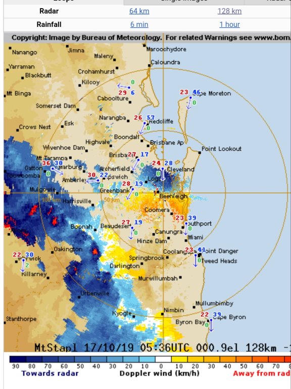 Doppler wind looks like it's packing a bit of a punch
|
|
|
|
|
|
Weather Forum
»
Australia Weather
»
SEQ and NE NSW
»
SE QLD and NE NSW - Day to Day Weather
Forum Jump
You cannot post new topics in this forum.
You cannot reply to topics in this forum.
You cannot delete your posts in this forum.
You cannot edit your posts in this forum.
You cannot create polls in this forum.
You cannot vote in polls in this forum.
Important Information:
The Weather Forum uses cookies. By continuing to browse this site, you are agreeing to our use of cookies.
More Details
Close
