Weather Forum
»
Australia Weather
»
SEQ and NE NSW
»
QLD trough and rain 26th Sep - 2nd Oct 2019
Rank: Advanced Member
Groups: Registered
Joined: 2/09/2019(UTC) Posts: 105  Location: Brisbane Thanks: 145 times
Was thanked: 561 time(s) in 103 post(s)
|
 Nah crikey, it’s just to do with the way different models parameterise convection. Nah crikey, it’s just to do with the way different models parameterise convection.
Most models produce CAPE and many other parameters as part of their suite of products, including ACCESS-R.
Monday still looks like featuring coastal shower activity starting to spread along the central and northern NSW coast then into parts of coastal SE QLD later or early Tuesday..... before extending further north to the Wide Bay and Capricornia Coast on Tuesday where some moderate falls are possible (aided by an upper trough moving up from NSW).
The more numerous thunderstorm activity on Tuesday looks like it may be a bit inland of the coast as far as SE QLD goes.
I can't see any huge falls for SE QLD itself but some locations near the coastal fringe and islands may see a nice drop as well as those locations which manage to get lucky under a storm or heavier showers.
P.S. ACCESS-G's going to completely replace ACCESS-R (currently scheduled date is December) because it's going to run at the same resolution as R as part of its next upgrade (but since there’s a grace period before all ACCESS-R data is switched off, not all websites may display the new version straight away). So you'll probably notice finer resolution in the ACCESS-G maps in the 3-7 day forecast time period once that happens.
Also worth noting that the current version of ACCESS-R has had a long known tendency for coastal locking i.e. cuts back precip over land by an unrealistical amount at night while maintaining it over the water which results in unrealistically steep gradients in nocturnal precip between land and sea. The decrease in convective precip over land at night does happen to some extent in the real world but ACCESS-R is known for doing it too much. This problem has been completely eliminated in the current version of ACCESS-C.
As a sidenote, the ACCESS-GE ensemble as well as the ACCESS-C ensemble and the next upgrade to ACCESS-C is in the pipeline although I’m not sure if they'll be made public.Edited by user Sunday, 29 September 2019 1:55:29 PM(UTC)
| Reason: Not specified
|
 6 users thanked Ken for this useful post.
|
|
|
|
Rank: Advanced Member
Groups: Registered
Joined: 24/08/2019(UTC) Posts: 292 Location: Country Victorian Thanks: 580 times
Was thanked: 503 time(s) in 194 post(s)
|
Originally Posted by: Ken 
Nah crikey, it’s just to do with the way different models parameterise convection.
Most models produce CAPE and many other parameters as part of their suite of products, including ACCESS-R.
Monday still looks like featuring coastal shower activity starting to spread along the central and northern NSW coast then into parts of coastal SE QLD later or early Tuesday..... before extending further north to the Wide Bay and Capricornia Coast on Tuesday where some moderate falls are possible (aided by an upper trough moving up from NSW).
The more numerous thunderstorm activity on Tuesday looks like it may be a bit inland of the coast as far as SE QLD goes.
I can't see any huge falls for SE QLD itself but some locations near the coastal fringe and islands may see a nice drop as well as those locations which manage to get lucky under a storm or heavier showers.
P.S. ACCESS-G's going to completely replace ACCESS-R (currently scheduled date is December) because it's going to run at the same resolution as R as part of its next upgrade (but since there’s a grace period before all ACCESS-R data is switched off, not all websites may display the new version straight away). So you'll probably notice finer resolution in the ACCESS-G maps in the 3-7 day forecast time period once that happens.
Also worth noting that the current version of ACCESS-R has had a long known tendency for coastal locking i.e. cuts back precip over land by an unrealistical amount at night while maintaining it over the water which results in unrealistically steep gradients in nocturnal precip between land and sea. The decrease in convective precip over land at night does happen to some extent in the real world but ACCESS-R is known for doing it too much. This problem has been completely eliminated in the current version of ACCESS-C.
As a sidenote, the ACCESS-GE ensemble as well as the ACCESS-C ensemble and the next upgrade to ACCESS-C is in the pipeline although I’m not sure if they'll be made public.
Thanks KEN. The nuts and bolts of models is something l know nothing about. So l totally accept what you say.
As l know this is one of your areas of expertise.
What l do look out for being a pattern observer is why GFS CAPE spatial pattern was spot on regarding position of activity, whereas ACC r was off the mark? Most other times it is spot on in positioning generally and so l look for answers.
Matching ACC against stormcast CAPE is something l have never done before and so the investigation begins Edited by user Sunday, 29 September 2019 2:23:12 PM(UTC)
| Reason: Not specified
|
5 users thanked crikey for this useful post.
|
|
|
|
Rank: Advanced Member
Groups: Registered
Joined: 15/09/2019(UTC) Posts: 39 Location: Forster NSW mid coast Thanks: 172 times
Was thanked: 135 time(s) in 39 post(s)
|
Tomorrow. Monday Looks very coastal with some higher CAPE just off shore from Brisbane to Sunshine coast You can call me the CAPE man  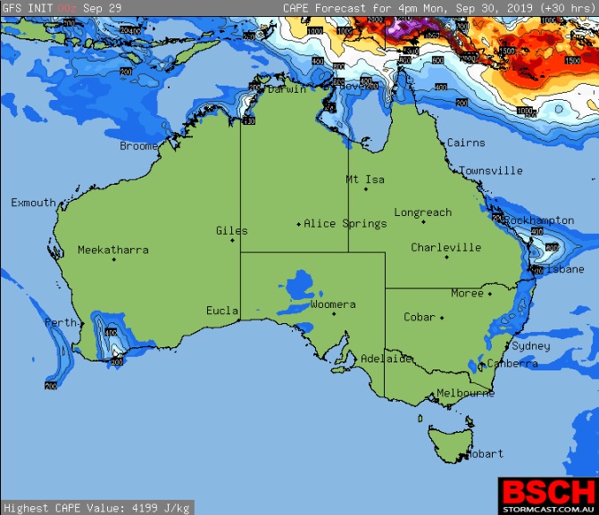
|
7 users thanked i4hanish for this useful post.
|
|
|
|
Rank: Advanced Member
Groups: Registered
Joined: 21/09/2019(UTC) Posts: 32 Location: Gold coast Thanks: 125 times
Was thanked: 126 time(s) in 31 post(s)
|
Glorious day on the Gold coast today. BOM forecast tomorrow 50% chance of 2mm So not a big day The rain totals from the storm burst yesterday. Not a bad spread. Looks like sunshine coast got the better deal 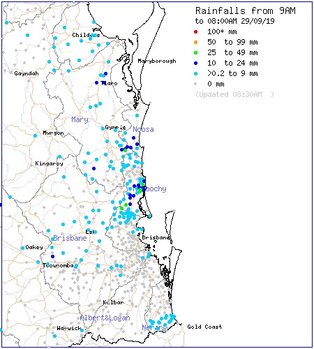
|
7 users thanked juztchillin for this useful post.
|
|
|
|
Rank: Advanced Member
Groups: Registered
Joined: 24/08/2019(UTC) Posts: 292 Location: Country Victorian Thanks: 580 times
Was thanked: 503 time(s) in 194 post(s)
|
This stalled trough is continuing into Tuesday and Wednesday . So an extension of date perhaps in this thread ?
ACC r is giving west of the divide a good chance or rains and may l suggest possible storms.
It looks as though Brisbane , Gold coast misses out here but activity could migrate east?
What are the other models saying for Tuesday??
The coastal signal runs from Sunshine coast right up to Rockhampton area.
I am going to have to get a map to see what inland towns could get wet and boy do they need this  
|
7 users thanked crikey for this useful post.
|
|
|
|
Rank: Advanced Member
Groups: Registered
Joined: 21/08/2019(UTC) Posts: 35 Location: Toowoomba Thanks: 29 times
Was thanked: 120 time(s) in 33 post(s)
|
Originally Posted by: i4hanish Tomorrow. Monday Looks very coastal with some higher CAPE just off shore from Brisbane to Sunshine coast You can call me the CAPE man Yep the cape crusader 
|
6 users thanked Skeetpete for this useful post.
|
|
|
|
Rank: Administration
Groups: Administrators
Joined: 9/08/2019(UTC)
Posts: 70
Thanks: 151 times
Was thanked: 98 time(s) in 41 post(s)
|
Originally Posted by: crikey [size=7]This stalled trough is continuing into Tuesday and Wednesday . So an extension of date perhaps in this thread ?
Hey Crikey, I have extended the dates.
|
7 users thanked Paul Atkins for this useful post.
|
|
|
|
Rank: Advanced Member
Groups: Registered
Joined: 2/09/2019(UTC) Posts: 105 Location: Brisbane Thanks: 145 times
Was thanked: 561 time(s) in 103 post(s)
|
  Originally Posted by: crikey Thanks KEN. The nuts and bolts of models is something l know nothing about. So l totally accept what you say.
As l know this is one of your areas of expertise.
What l do look out for being a pattern observer is why GFS CAPE spatial pattern was spot on regarding position of activity, whereas ACC r was off the mark? Most other times it is spot on in positioning generally and so l look for answers.
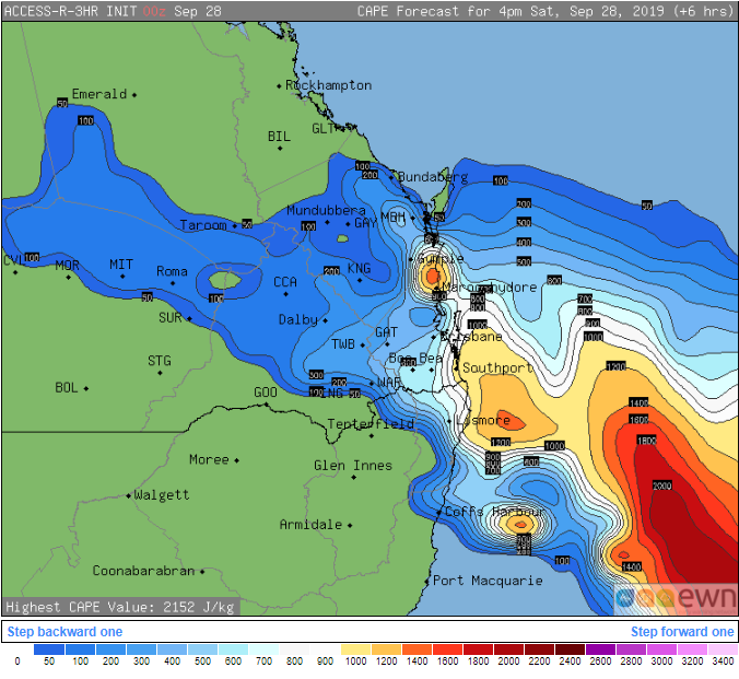
Matching ACC against stormcast CAPE is something l have never done before and so the investigation begins GFS CAPE is usually close to the mark when it comes to typical surface-based thunderstorm areas because of the way CAPE is handled by the model. But there are notable exceptions. For example, it'll often show extreme values off the northwest coast of Australia during the build-up season as well as parts of the tropics even though little to no thunderstorm activity ends up occurring. This is because by default, the CAPE fields displayed on Stormcast is surface based CAPE i.e. CAPE calculated from a parcel that's assumed to rise from the surface and therefore possess the GFS surface forecast temp and dewpoint for that point. In these setups, there's only a very shallow layer of good moisture near the surface which means GFS forecasts those parcels to condense at a low height then cool at the saturated adiabatic lapse rate as it rises further (it stays warmer than the surrounding air and therefore gives rise to unrealistically extreme CAPE values). But on typical hot sunny days, parcels rise from a mixed layer thousands of feet deep in the lower levels so they don't have the same high temp or dewpoint as parcels rising from the surface, and therefore their true CAPE or instability is lower. Conversely, GFS surface based CAPE often tends to show very low or even non-existent values for dry inland storms even though it results in lots of lightning - this is because convection is helped by a layer of moisture aloft rather than the surface where the surface based CAPE values represent. This is why there's different types of CAPE that are looked at by forecasters such as mixed layer CAPE in the lowest X hpa of the atmosphere, most unstable (MU) CAPE which uses parcels rising from a level that yields the most CAPE, effective layer CAPE which uses parcels rising from a level where parcels are likely to start rising freely on their own from, etc. Above is the ACCESS-R CAPE for 4pm yesterday based on its 00z run. I'm allowed to post this particular version. And the preceding image is the detected lightning within the 24hrs after 8am Saturday. As you can see, the general area is reasonably well represented by the storms that ended up occurring although note the low values inland which is typical of inland low-rainfall storms because convection is encouraged by moisture aloft. Edited by user Sunday, 29 September 2019 7:36:58 PM(UTC)
| Reason: Not specified
|
9 users thanked Ken for this useful post.
|
|
|
|
Rank: Advanced Member
Groups: Registered
Joined: 23/08/2019(UTC) Posts: 155 Location: Narangba Thanks: 280 times
Was thanked: 442 time(s) in 136 post(s)
|
Thank you so much for putting these wonderful and detailed explanations together Ken. They are greatly appreciated
|
5 users thanked CantSpellNarangba for this useful post.
|
|
|
|
Rank: Advanced Member
Groups: Registered, Administrators Joined: 21/08/2019(UTC) Posts: 941 Location: Brisbane Northside Thanks: 1198 times
Was thanked: 1136 time(s) in 674 post(s)
|
|
Colin Maitland. |
3 users thanked Colmait for this useful post.
|
|
|
|
Rank: Advanced Member
Groups: Registered, Administrators Joined: 21/08/2019(UTC) Posts: 941 Location: Brisbane Northside Thanks: 1198 times
Was thanked: 1136 time(s) in 674 post(s)
|
I think I miss read your post Crikey. I thought you needed a map, but it looks like you were saying you are going to look at a map/s. DoH. But I will leave the links up for anyone that may not have it.    Cheers. |
Colin Maitland. |
2 users thanked Colmait for this useful post.
|
|
|
|
Rank: Advanced Member
Groups: Registered
Joined: 25/08/2019(UTC) Posts: 1,839 Location: Ferny Grove Thanks: 985 times
Was thanked: 856 time(s) in 419 post(s)
|
Sunny day today with near average temperature. Near average dew point during today while slowly rising before falling slightly tonight. Relative humidity have been near average. E to SE winds became mostly E to NE later and is now is calm. Last 24 hours: |
|
2 users thanked Falling_Droplet for this useful post.
|
|
|
|
Rank: Advanced Member
Groups: Registered
Joined: 23/08/2019(UTC) Posts: 155 Location: Narangba Thanks: 280 times
Was thanked: 442 time(s) in 136 post(s)
|
Wow. I didn't expect this forecast this morning for Brisbane. 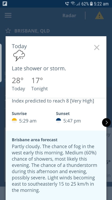
|
3 users thanked CantSpellNarangba for this useful post.
|
|
|
|
Rank: Advanced Member
Groups: Registered
Joined: 25/08/2019(UTC) Posts: 1,839 Location: Ferny Grove Thanks: 985 times
Was thanked: 856 time(s) in 419 post(s)
|
Ferny Grove Weather
Date: 30 Sep 2019
Time: 7:50 AM
Min Temp since 9am yesterday: 16.7 C
Max Temp since 9am yesterday: 26.8 C
Min Ground Temp: 13.6 C
Rain since 9am yesterday: 0 mm
Temperature: 21.1 C
Relative Humidity: 64 %
Dew Point: 14 C
MSL Pressure: 1020.3 hPa
Wind Speed: 7 kph - light breeze
Wind Direction: WSW
Present Weather: Clouds generally forming or developing during the preceding hour
Visibility: 20km to 39km - Very Good Visibility
Cloud Cover: 6/8
Ground State: Ground dry
Notes of yesterday weather - 29/9/19: Partly cloudy with cu and sc clouds in the early morning, becoming sunny during the morning with some cu clouds persisting into the late morning before clearing. The temperature rose briefly between 12 am and 1 am before falling. Near average dew point and generally stable early before rising during the morning and stabilising from the late afternoon and fell slightly in the evening. Light WSW to SSW winds from 12am and 1 am with light W winds occasionally early before a SE to E wind change during the early morning becoming ESE to NE from mid morning with some N to NE winds in the morning. Later in the afternoon winds were ENE to NNE and became calm in the evening.
Today: Temperature early today before sunrise was stable or slowly rose instead of falling. Dew point have been near average and slowly rising. Relative humidity have been near average. Light W to SW winds at times early and S to SW in the last hour.
|
|
2 users thanked Falling_Droplet for this useful post.
|
|
|
|
Rank: Advanced Member
Groups: Registered
Joined: 27/08/2019(UTC) Posts: 47 Location: Bayside Thanks: 51 times
Was thanked: 104 time(s) in 35 post(s)
|
Has anyine seen the soundings for today for storm chances
Feels like a strom day
|
2 users thanked Tsunami for this useful post.
|
|
|
|
Rank: Advanced Member
Groups: Registered
Joined: 2/09/2019(UTC) Posts: 105 Location: Brisbane Thanks: 145 times
Was thanked: 561 time(s) in 103 post(s)
|
Originally Posted by: Tsunami Has anyine seen the soundings for today for storm chances
Feels like a strom day Yeah, I had a detailed look at ACCESS-R, etc soundings for various points around the region. Below is a summary of what I said elsewhere: " There's definitely more than enough directional and speed shear (caused by the freshening ESE onshore low level flow after the small weak near-coastal low drifts away and weakens, undercutting the strong westerlies above) to support severe storms.
But instability is very modest in most of SE QLD so I think it'll be a case of "only a slight chance but if anything got tall enough, it'd tap into the shear and potentially become severe". "If" being the operative word.
Both EC lightning and ACCESS-R soundings look somewhat more favourable in northern areas such as the Wide Bay and Burnett, and some western parts of SE QLD but it could conceivably go either way.
ACCESS-C tries to develop some convection around the Scenic Rim ranges which then drifts in a rough NNW direction later as it grows somewhat. Will be a wait and see situation with today.
Overall though, today looks far from epic to me. "Edited by user Monday, 30 September 2019 12:18:54 PM(UTC)
| Reason: Not specified
|
5 users thanked Ken for this useful post.
|
|
|
|
Rank: Advanced Member
Groups: Registered
Joined: 13/09/2019(UTC)
Posts: 118
Location: Caboolture (the next Las Vegas!)
Thanks: 215 times
Was thanked: 297 time(s) in 100 post(s)
|
Great summary Ken.. I like If's, they will make the afternoon exciting.
Thank you.
|
4 users thanked DelBoy for this useful post.
|
|
|
|
Rank: Advanced Member
Groups: Registered
Joined: 27/08/2019(UTC) Posts: 47 Location: Bayside Thanks: 51 times
Was thanked: 104 time(s) in 35 post(s)
|
Thanks Ken
Oh well something to watch
|
3 users thanked Tsunami for this useful post.
|
|
|
|
Rank: Advanced Member
Groups: Registered
Joined: 2/09/2019(UTC) Posts: 105 Location: Brisbane Thanks: 145 times
Was thanked: 561 time(s) in 103 post(s)
|
Originally Posted by: Tsunami Thanks Ken
Oh well something to watch I'm actually not too hopeful for anything more than localised storms for SE QLD goes to be honest. But regardless, shower activity should start increasing from later tonight into tomorrow in the region.
|
4 users thanked Ken for this useful post.
|
|
|
|
Rank: Advanced Member
Groups: Registered
Joined: 21/08/2019(UTC) Posts: 185 Location: Ocean View Thanks: 359 times
Was thanked: 539 time(s) in 161 post(s)
|
Originally Posted by: Tsunami Has anyine seen the soundings for today for storm chances
Feels like a strom day This is a copy of this morning (00z) from YBBN. - I use a program called Digital Atmosphere to generate it, because I can then play with some other settings. 
|
5 users thanked Pabloako for this useful post.
|
|
|
|
Weather Forum
»
Australia Weather
»
SEQ and NE NSW
»
QLD trough and rain 26th Sep - 2nd Oct 2019
Forum Jump
You cannot post new topics in this forum.
You cannot reply to topics in this forum.
You cannot delete your posts in this forum.
You cannot edit your posts in this forum.
You cannot create polls in this forum.
You cannot vote in polls in this forum.
Important Information:
The Weather Forum uses cookies. By continuing to browse this site, you are agreeing to our use of cookies.
More Details
Close
