Weather Forum
»
Australia Weather
»
SEQ and NE NSW
»
SE QLD and NE NSW - Day to Day Weather
Rank: Advanced Member
Groups: Registered
Joined: 21/08/2019(UTC) Posts: 185  Location: Ocean View Thanks: 359 times
Was thanked: 539 time(s) in 161 post(s)
|
Hi Ken and thank you for pointing that out. I was trying to find the text.
I Guess the forecast regions are quite large geographical areas, so they can't put the maximum rating in the table, without causing alarm, so I would assume they put the average rating in for that region? That way though, you will always have some areas lower and some areas higher. (Just me thinking out loud)
|
 3 users thanked Pabloako for this useful post.
|
|
|
|
Rank: Advanced Member
Groups: Registered
Joined: 2/09/2019(UTC) Posts: 105 Location: Brisbane Thanks: 145 times
Was thanked: 561 time(s) in 103 post(s)
|
Yep pretty much pabloako, having an entire district/s labelled as Catastrophic (in situations like tomorrow's where catastrophic risk is forecast to be in isolated pockets) would be misleading and wouldn't really be representative of the majority of the region.
It's better to say what the FDR's will be like overall for a region and add that isolated Catastrophic FDR's are possible.
Either way though, the fire weather's going to be nasty tomorrow so one can only hope any existing are well-contained, any new fires are contained quickly, and that arsonists, cigarette butt throwers, etc aren't out in force.
Even though forecast FDR's decrease a bit on Saturday, the gusty winds that day don't leave much room for complacency on that day either.
|
4 users thanked Ken for this useful post.
|
|
|
|
Rank: Advanced Member
Groups: Registered
Joined: 21/08/2019(UTC) Posts: 185 Location: Ocean View Thanks: 359 times
Was thanked: 539 time(s) in 161 post(s)
|
Originally Posted by: Ken  Yep pretty much pabloako, having an entire district/s labelled as Catastrophic (in situations like tomorrow's where catastrophic risk is forecast to be in isolated pockets) would be misleading and wouldn't really be representative of the majority of the region.
It's better to say what the FDR's will be like overall for a region and add that isolated Catastrophic FDR's are possible.
Either way though, the fire weather's going to be nasty tomorrow so one can only hope any existing are well-contained, any new fires are contained quickly, and that arsonists, cigarette butt throwers, etc aren't out in force.
Even though forecast FDR's decrease a bit on Saturday, the gusty winds that day don't leave much room for complacency on that day either. I certainly hope so too for those areas. In addition, due to my location up here in Ocean View, surrounded by Gum trees and on the top of a steep hill, I am concerned for here! Fingers crossed the day passes without any issues.
|
5 users thanked Pabloako for this useful post.
|
|
|
|
Rank: Advanced Member
Groups: Registered
Joined: 2/09/2019(UTC) Posts: 105 Location: Brisbane Thanks: 145 times
Was thanked: 561 time(s) in 103 post(s)
|
Here's the Bureau's max FFDI and GFDI maps for tomorrow, Friday. Generally speaking, anything above 50 is considered severe: 
|
7 users thanked Ken for this useful post.
|
|
|
|
Rank: Advanced Member
Groups: Registered
Joined: 23/08/2019(UTC) Posts: 155 Location: Narangba Thanks: 280 times
Was thanked: 442 time(s) in 136 post(s)
|
Thats great Ken. Thanks for posting. I guess it is true that a picture speak a thousand words! I am still working through my "Weather for dummies" book, but would you say that in summary, the heat and strong wind change, on top of the very dry conditions is what is causing the Severe rating to the west and as the change pushes East (I think from looking at GFS this morning it will get to SE QLD by about 7pm), that by then SE QLD will be starting to cool down and that stops our conditions being as high? I bet I am wrong though!  Edited by user Thursday, 5 September 2019 7:18:39 PM(UTC)
| Reason: Changed to 7pm
|
6 users thanked CantSpellNarangba for this useful post.
|
|
|
|
Rank: Advanced Member
Groups: Registered
Joined: 2/09/2019(UTC) Posts: 105 Location: Brisbane Thanks: 145 times
Was thanked: 561 time(s) in 103 post(s)
|
Yep I’d agree with that :) One of the big contributors to the highest FDI values over inland parts is the fact that the winds are expected to be the strongest there (setting aside the fuel states for the moment). When comparing wind with temps, wind is by far the biggest mechanism in spreading fire quickly. Therefore even after temps cool down after the cold front sweeps through (EC currently forecasts this to occur overnight), the gusty winds persisting into Saturday mean that fire dangers won’t go down quickly. Edited by user Thursday, 5 September 2019 8:30:09 PM(UTC)
| Reason: Not specified
|
6 users thanked Ken for this useful post.
|
|
|
|
Rank: Advanced Member
Groups: Registered
Joined: 25/08/2019(UTC) Posts: 1,839 Location: Ferny Grove Thanks: 985 times
Was thanked: 856 time(s) in 419 post(s)
|
Another day of low humidity, but not quite as extreme as yesterday. Relative humidity fell to a low of 8% hovering around 10 to 15% in the afternoon. Dew point varied quite bit and in the negative for much of the day. Absolutely no moisture coming on the coast with E to NE winds.
A new high record yesterday for the last 10 years for my location for daily temperature range of 25.8 C (from 8 C to 34 C). This is the highest for September and any month; previously the highest for this for all months: 24.4 C on 17 August 2018 and for September: 22.3 C on 16 September 2017.
Yesterday's maximum temperature was only the second time in last 10 years of a 30 C + day in early September. The highest temperature in early September was 31.3 C on 4 September 2017.
Tomorrow is looking quite concerning with the fire ratings and the conditions. I hope this is not a sign for things to come but it looks like this only the start of it. |
|
3 users thanked Falling_Droplet for this useful post.
|
|
|
|
Rank: Advanced Member
Groups: Registered
Joined: 21/08/2019(UTC) Posts: 185 Location: Ocean View Thanks: 359 times
Was thanked: 539 time(s) in 161 post(s)
|
Originally Posted by: Falling_Droplet ......
Tomorrow is looking quite concerning with the fire ratings and the conditions. I hope this is not a sign for things to come but it looks like this only the start of it. It sure is. I crossing all fingers and hoping for an uneventful day, apart from a bit of dust may may the sunset look nice.
|
3 users thanked Pabloako for this useful post.
|
|
|
|
Rank: Advanced Member
Groups: Registered
Joined: 23/08/2019(UTC) Posts: 155 Location: Narangba Thanks: 280 times
Was thanked: 442 time(s) in 136 post(s)
|
|
3 users thanked CantSpellNarangba for this useful post.
|
|
|
|
Rank: Advanced Member
Groups: Registered
Joined: 21/08/2019(UTC) Posts: 182 Location: Wynnum North Thanks: 656 times
Was thanked: 381 time(s) in 167 post(s)
|
WYNNUM NORTH ( 27.4S 153.2E ) - WEATHER
DATE....6 SEP 2019...TIME...0740
CURRENT TEMPERATURE...16.8C
CURRENT HUMIDITY........81%
CURRENT DEW POINT.......13C
CURRENT WIND DIR/SPEED..WSW 2Kph
CURRENT MSL PRESSURE...1015.2Hpa
CURRENT VISIBILITY......20Km
CURRENT CLOUD..........Nil
CURRENT WEATHER......Smoke haze
RAIN SINCE 0900 THURSDAY..0.0mm
SUMMARY LAST 24 HOURS
YESTERDAY'S MAX TEMP. .......27.9C
THIS MORNING'S MIN TEMP......10.1C
PAST 24 HOURS TEMP ANOMALY..+0.40C
THIS MORNING'S GRASS MIN......8.1C
AVERAGE 24 HOUR DEW POINT......12C
AVERAGE 24 HOUR MSLP........1014.8Hpa
MAX WIND GUST LAST 24 HOURS..N 33Kph at 1713
PAST 24 HR SIGNIFICANT WEATHER..Smoke haze. |
Wyn Nth 2020-Jan165, |
2 users thanked retired weather man for this useful post.
|
|
|
|
Rank: Advanced Member
Groups: Registered
Joined: 25/08/2019(UTC) Posts: 1,839 Location: Ferny Grove Thanks: 985 times
Was thanked: 856 time(s) in 419 post(s)
|
Ferny Grove Weather
Date: 6 Sep 2019
Time: 7:40 AM
Min Temp since 9am yesterday: 9.6 C
Max Temp since 9am yesterday: 32.4 C
Min Ground Temp: 6.9 C
Rain since 9am yesterday: 0 mm
Temperature: 32.4 C
Relative Humidity: 59 %
Dew Point: 6.5 C
MSL Pressure: 1014.5 hPa
Wind Speed: Calm
Wind Direction: Calm
Present Weather: No cloud development observed
Visibility: 20km to 39km - Very Good Visibility
Cloud Cover: 0/8
Ground State: Ground dry
Notes of yesterday weather - 5/9/19: Fine and sunny. A cool morning and a hot day. Smoke haze. Low and stable dew point early, falling further during the morning but was quite variable before rising from the early afternoon while remaining low and variable. In the evening the dew point became stable and moderately low before falling slowly later in the evening. The temperature was stable for 2 hours during the middle of the day. Low relative humidity and very low during the day and fluctuated in late morning and afternoon. Light E to SE winds in early morning, E to NE from mid morning, ENE to NE in late afternoon, followed light and variable winds occasionally in the evening.
|
|
3 users thanked Falling_Droplet for this useful post.
|
|
|
|
Rank: Advanced Member
Groups: Registered
Joined: 2/09/2019(UTC) Posts: 105 Location: Brisbane Thanks: 145 times
Was thanked: 561 time(s) in 103 post(s)
|
 I decided to extend the output from my fire risk script out to next Monday due to very gusty W to SW winds persisting through til the start of the working week as the low deepens while it moves across the Tasman. The script takes into account winds, relative humidity, soil moisture (as a proxy for how cured vegetation is), and very recent rainfall... the outputs are then calibrated to past official fire danger ratings - but it doesn't take into account arid areas where vegetation is sparse, nor how much fuel there is. Hope all existing and new fires are quickly contained today - we might get off lucky then.
|
7 users thanked Ken for this useful post.
|
|
|
|
Rank: Advanced Member
Groups: Registered
Joined: 23/08/2019(UTC) Posts: 155 Location: Narangba Thanks: 280 times
Was thanked: 442 time(s) in 136 post(s)
|
That's excellent Ken. Thank you for sharing your custom images. They show more than the general public media images!
Fingers crossed for an uneventful day.
|
5 users thanked CantSpellNarangba for this useful post.
|
|
|
|
Rank: Advanced Member
Groups: Registered
Joined: 21/08/2019(UTC) Posts: 185 Location: Ocean View Thanks: 359 times
Was thanked: 539 time(s) in 161 post(s)
|
Currently 31°C and a dew point of 0.0° here. My grass is like Wheetbix and the DP is still dropping. Wind is gusting to 25Kts too. Edited by user Friday, 6 September 2019 12:27:20 PM(UTC)
| Reason: Not specified
|
4 users thanked Pabloako for this useful post.
|
|
|
|
Rank: Advanced Member
Groups: Registered
Joined: 25/08/2019(UTC) Posts: 1,839 Location: Ferny Grove Thanks: 985 times
Was thanked: 856 time(s) in 419 post(s)
|
Incredibly low humidity which fell so quickly and dew point between -20 C and - 30C in the last hour. Relative humidity has between 1 and 4 % in the last two hours. The temperature has risen to 34 C, rising 8 C in 1 hr. Not accounting for fuel load I am measuring consistently severe FFDI values. Edited by user Friday, 6 September 2019 1:24:20 PM(UTC)
| Reason: Not specified |
|
3 users thanked Falling_Droplet for this useful post.
|
|
|
|
Rank: Advanced Member
Groups: Registered
Joined: 21/08/2019(UTC) Posts: 185 Location: Ocean View Thanks: 359 times
Was thanked: 539 time(s) in 161 post(s)
|
Some current BOM Obs from around our area. 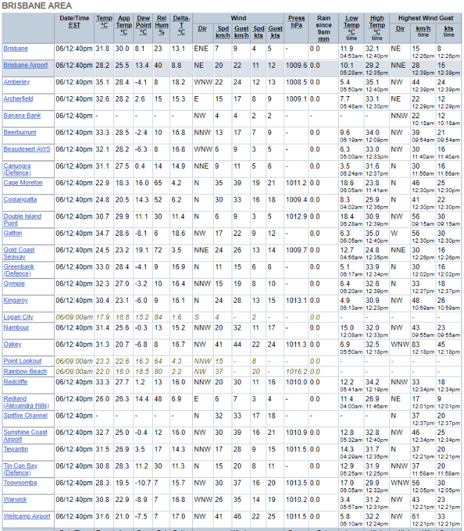   The mobile station at Inglewood is drastically different to others in the area, with regards to Dew Points. I wonder if that would be just local conditions, or a sensor issue? Edited by user Friday, 6 September 2019 12:55:20 PM(UTC)
| Reason: Not specified
|
6 users thanked Pabloako for this useful post.
|
|
|
|
Rank: Advanced Member
Groups: Registered
Joined: 24/08/2019(UTC) Posts: 292 Location: Country Victorian Thanks: 580 times
Was thanked: 503 time(s) in 194 post(s)
|
Some amazing statistics you have posted there. 'droplet'.,Thanks for that.I did a retweet of your stats' to my twitter from this page. Re tweet button works well but doesn't open a new tab and l found it difficult to get back to the page l was reading.You have to click back button twice.Can you change that Paul so re tweet opens a new tab or is that an issue with my browser? ACC r is showing quite a well defined wind change line in QLD at around 7pm tonight. and a very weak patch of precip signal west of divide.  source http://www.bom.gov.au/au...chartSubmit=Refresh+View
|
6 users thanked crikey for this useful post.
|
|
|
|
Rank: Advanced Member
Groups: Registered
Joined: 21/08/2019(UTC) Posts: 185 Location: Ocean View Thanks: 359 times
Was thanked: 539 time(s) in 161 post(s)
|
Here are some temps from around SEQ, based on BOM data... 
|
6 users thanked Pabloako for this useful post.
|
|
|
|
Rank: Advanced Member
Groups: Registered
Joined: 21/08/2019(UTC) Posts: 182 Location: Wynnum North Thanks: 656 times
Was thanked: 381 time(s) in 167 post(s)
|
Wynnum Nth max temp today 30.7C, lowest RH 27% which is not all that low compared to some recently here ( down to 9% ). |
Wyn Nth 2020-Jan165, |
3 users thanked retired weather man for this useful post.
|
|
|
|
Rank: Advanced Member
Groups: Registered
Joined: 26/08/2019(UTC) Posts: 122 Location: Travel but often NSW Thanks: 168 times
Was thanked: 90 time(s) in 53 post(s)
|
|
3 users thanked snowbunny for this useful post.
|
|
|
|
Weather Forum
»
Australia Weather
»
SEQ and NE NSW
»
SE QLD and NE NSW - Day to Day Weather
Forum Jump
You cannot post new topics in this forum.
You cannot reply to topics in this forum.
You cannot delete your posts in this forum.
You cannot edit your posts in this forum.
You cannot create polls in this forum.
You cannot vote in polls in this forum.
Important Information:
The Weather Forum uses cookies. By continuing to browse this site, you are agreeing to our use of cookies.
More Details
Close
