Rank: Advanced Member
Groups: Registered
Joined: 24/08/2019(UTC) Posts: 292  Location: Country Victorian Thanks: 580 times
Was thanked: 503 time(s) in 194 post(s)
|
 The monsoon trough looks active all this week at least Cross equatorial strong of the NW of Darwin. The chance for cyclogenesis is high as this is coupled with strong inflow into the southern flank of the trough courtesy of some strong mid latitude highs currently. Here is a snap of wind fields showing this tropical low off NW Darwin already has good symmetry. ACCESS g suggests this will continue in the next week with rapid intensification. A small but deep TC. ACCESS has this TC maintains significant strength even after landfall. Later in the week say Friday/Saturday. The monsoon trough establishes in the coral sea off the far north coast. There are 2 cross equatorial infeeds into the peninsula and coral region and strong high pressure underneath to give her a spin of possible multiple tropical lows. Firstly hear are the current promising wind fields just off the coast of Nw Darwin today. Nicely intact with good symmetry! Edited by user Tuesday, 19 January 2021 1:00:41 PM(UTC)
| Reason: Not specified
|
 1 user thanked crikey for this useful post.
|
|
|
|
Rank: Advanced Member
Groups: Registered
Joined: 24/08/2019(UTC) Posts: 292 Location: Country Victorian Thanks: 580 times
Was thanked: 503 time(s) in 194 post(s)
|
Two tropical lows in the coral sea on Saturday. ACCESS g has one tracking eastward and the other southward They don’t appear to be cyclones but tropical storms. The southerly tracker stays of shore but looks to get nearer the mid coast by Wednesday as high pressure rigging drops away. One to watch as we all know these tropical systems bring some rain and severe weather. http://www.bom.gov.au/au...harts/viewer/index.shtml Edited by user Thursday, 21 January 2021 11:58:21 AM(UTC)
| Reason: Not specified
|
|
|
|
|
|
Rank: Advanced Member
Groups: Registered
Joined: 12/02/2020(UTC) Posts: 781 Location: Daintree Thanks: 1290 times
Was thanked: 1074 time(s) in 603 post(s)
|
Originally Posted by: crikey  Two tropical lows in the coral sea on Saturday.
ACCESS g has one tracking eastward and the other southward
They don’t appear to be cyclones but tropical storms.
The southerly tracker stays of shore but looks to get nearer the mid coast by Wednesday as high pressure rigging drops away.
One to watch as we all know these tropical systems bring some rain and severe weather.
] I'm more interested in what GFS has in the gulf a week or so out. It's been there for a few days now. Cheers |
|
|
|
|
|
|
Rank: Advanced Member
Groups: Registered
Joined: 24/08/2019(UTC) Posts: 292 Location: Country Victorian Thanks: 580 times
Was thanked: 503 time(s) in 194 post(s)
|
Quote from FNQbunyip I'm more interested in what GFS has in the gulf a week or so out. It's been there for a few days now. Ok. Interesting. I don’t follow mid range forecasts myself but 7 day ACCESS g does have a small tropical low up in the gulf later in the week. I will check that out soon. Thanks for your input ———— ACCESS g did a downgrade of the WA TC. BOM confirming with the tracking showing the current low may get a name as CAT 1 by 8pm tonight. WA obs showing Mandorra pressure dropping down to 996 hPa currently . They had 105 mm of rain yesterday. Highest gust there so far 69 km/hr. The major ports will breathe a sigh of relief.  Edited by user Friday, 22 January 2021 1:41:41 PM(UTC)
| Reason: Not specified
|
1 user thanked crikey for this useful post.
|
|
|
|
Rank: Advanced Member
Groups: Registered
Joined: 24/08/2019(UTC) Posts: 292 Location: Country Victorian Thanks: 580 times
Was thanked: 503 time(s) in 194 post(s)
|
 ACCESS g showing a low in the gulf Wednesday. Trying to build some momentum on the western coastline. ACCESS suggesting our little friend over in WA is not going to go quietly. Some amazing bursts of extreme weather as it transitions SE through the interior and into SA. Then links in to southern troughing to give southern VIC a touch up. Could’ve an interesting weather watch this week. http://www.bom.gov.au/au...harts/viewer/index.shtmlEdited by user Friday, 22 January 2021 2:01:52 PM(UTC)
| Reason: Not specified
|
1 user thanked crikey for this useful post.
|
|
|
|
Rank: Advanced Member
Groups: Registered
Joined: 24/08/2019(UTC) Posts: 292 Location: Country Victorian Thanks: 580 times
Was thanked: 503 time(s) in 194 post(s)
|
 Further to the tropical low in the gulf this Wednesday or earlier. I have had a look at the all important surface synoptic windstreams crucial for good strong cyclogenesis. This snap l have taken below shows fabulous cross equatorial flow right across our region and beyond. You can see some Nw input into this low in the gulf. Now underneath need some good strong SE input from a well formed high to consolidate the spin or cyclogenesis. That is not there on this particular shot but doesn’t mean it won’t happen. There could be multiple lows from this fabulous cross equatorial currently. Certainly interesting couple of weeks ahead one would think before this favourable pattern changes. ACCESS is showing cyclogenesis here on Wednesday. You can see the heightened strength in the wind fields. http://www.bom.gov.au/au...chartSubmit=Refresh+ViewEdited by user Friday, 22 January 2021 2:22:54 PM(UTC)
| Reason: Not specified
|
3 users thanked crikey for this useful post.
|
|
|
|
Rank: Advanced Member
Groups: Registered
Joined: 12/02/2020(UTC) Posts: 781 Location: Daintree Thanks: 1290 times
Was thanked: 1074 time(s) in 603 post(s)
|
I managed a station on the Nullabore in the '90's any real rain had to come for a cyclone crossing
the Pilbara coast and tracking down through the deserts of WA. We had a record of 22" about '93
Plenty of historical tracks to show that.
This little low could do wonders for all that inland country.
I'm still keen on a good gulf low/cyclone, the right setup could give a lot of inland QLD a much needed drink.
Cheers
|
|
2 users thanked FNQ Bunyip for this useful post.
|
|
|
|
Rank: Advanced Member
Groups: Registered
Joined: 24/08/2019(UTC) Posts: 292 Location: Country Victorian Thanks: 580 times
Was thanked: 503 time(s) in 194 post(s)
|
Living in the Nullabor region would of been a once in a lifetime experience Bunyip’. We went of the Nullabor a couple of years ago and a once in a lifetime experience for us. We saw storms at a stop at Nullabor The open expanse gives storms there a real portrait view. The sounds of howling wild dogs in the night and heaps of kangaroo road kill . ACCESS is currently suggesting a small squat TC in the gulf tracking east over the top of the gulf next Thursday/ Friday Another point of interest is the weak tropical low that will drop into the mid coast of Qld around the same time. Considerable troughing down the coast of Qld . Actually l should add the central qld interior rain looks ok as well with an embedded low in trough in central qld. Looks wet along the coast from moist onshore feeding into coastal troughing. Nice to have some weather excitement. http://www.bom.gov.au/au...harts/viewer/index.shtml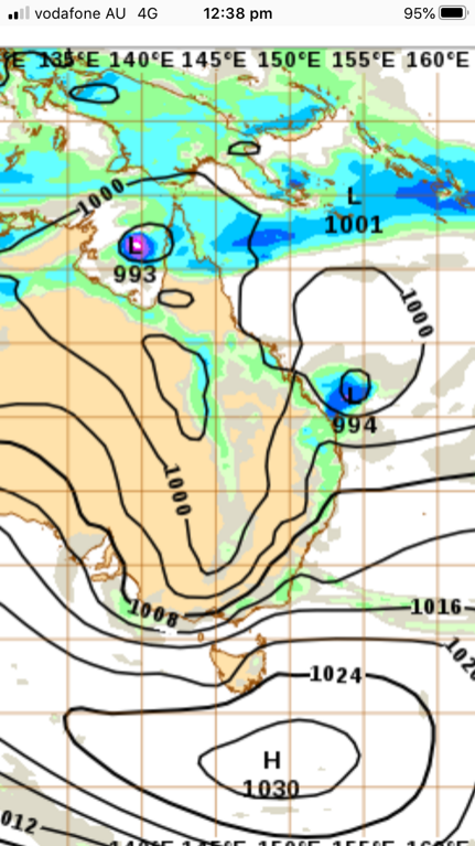 Edited by user Saturday, 23 January 2021 11:55:54 AM(UTC)
| Reason: Not specified
|
2 users thanked crikey for this useful post.
|
|
|
|
Rank: Advanced Member
Groups: Registered
Joined: 24/08/2019(UTC) Posts: 292 Location: Country Victorian Thanks: 580 times
Was thanked: 503 time(s) in 194 post(s)
|
 ACCESS g next Saturday 30thJan 2021 Cyclone on the far north coast, It is likely to initialise this Tuesday in the gulf as a small tropical low. Then slowly build ( cyclogenesis) across the top of the peninsula. Edited by user Sunday, 24 January 2021 4:34:56 PM(UTC)
| Reason: Not specified
|
2 users thanked crikey for this useful post.
|
|
|
|
Rank: Advanced Member
Groups: Registered
Joined: 24/08/2019(UTC) Posts: 292 Location: Country Victorian Thanks: 580 times
Was thanked: 503 time(s) in 194 post(s)
|
There is a chance we could have 2 or 3 cyclones in the Australian region at the same time by next Sunday the 31st January The TC in the mid coral sea intensifies on transition south. High pressure ridging up the coast may protect the mid coast.  Edited by user Monday, 25 January 2021 12:34:10 PM(UTC)
| Reason: Not specified
|
1 user thanked crikey for this useful post.
|
|
|
|
Rank: Advanced Member
Groups: Registered
Joined: 12/02/2020(UTC) Posts: 781 Location: Daintree Thanks: 1290 times
Was thanked: 1074 time(s) in 603 post(s)
|
Yeah the Low in the gulf looks to be developing nicely.
Could be an interesting week of weather.
Cheers
|
|
|
|
|
|
|
Rank: Member
Groups: Registered
Joined: 1/09/2019(UTC) Posts: 24 Location: darwin Thanks: 23 times
Was thanked: 38 time(s) in 19 post(s)
|
BOM has the low in the gulf as a cyclone on the 28th Jan. So that’s about Thursday. Tracking map posted below. Expecting a CAT 2 whilst in the gulf by the 29th Jan More details and warning from this link http://www.bom.gov.au/products/IDQ65002.shtml Edited by user Tuesday, 26 January 2021 12:34:11 PM(UTC)
| Reason: Not specified
|
2 users thanked tropicalbomb for this useful post.
|
|
|
|
Rank: Advanced Member
Groups: Registered
Joined: 24/08/2019(UTC) Posts: 292 Location: Country Victorian Thanks: 580 times
Was thanked: 503 time(s) in 194 post(s)
|
Downgrade for the expected TC in the gulf. By BOM. Currently a tropical low and looks to cross the tip in the coming days as such ACCESS g has this re intensifying in the coral sea. Current advice by BOM is that it will not impact coast. I think l will keep an open mind here. The gulf prediction didn’t eventuate so maybe the tracking in the coral may change.. Here in ACCESS for next sunday. TC looks close to the coast here Note the 3 active cyclones on this snap attached to an active monsoon trough  Edited by user Wednesday, 27 January 2021 1:19:05 PM(UTC)
| Reason: Not specified
|
3 users thanked crikey for this useful post.
|
|
|
|
Rank: Advanced Member
Groups: Registered
Joined: 24/08/2019(UTC) Posts: 292 Location: Country Victorian Thanks: 580 times
Was thanked: 503 time(s) in 194 post(s)
|
 ACCESS g still keen on a TC in the coral sea Here is a snap of forecast for 6 days from today Wednesday the 3rd Feb Massive moisture infeed into this TC circulation from the equatorial. And look at that circulation in the west. I don’t think they get named unless they are at sea. Edited by user Thursday, 28 January 2021 11:36:08 AM(UTC)
| Reason: Not specified
|
2 users thanked crikey for this useful post.
|
|
|
|
Rank: Advanced Member
Groups: Registered
Joined: 24/08/2019(UTC) Posts: 292 Location: Country Victorian Thanks: 580 times
Was thanked: 503 time(s) in 194 post(s)
|
ACCESS g has the coral low intensifying and tracking east during the week heading to the usual Pacific islands. High pressure keeps the TC from transitioning toward our coast. That is current forecast of course. The tropical low on the western coast is expected to slide SW down the coast and intensify.(ACCESS ) BOM tracking has this as a cyclone putting its eye in the water 1st Feb and off shore Port Hedland CAT 2. 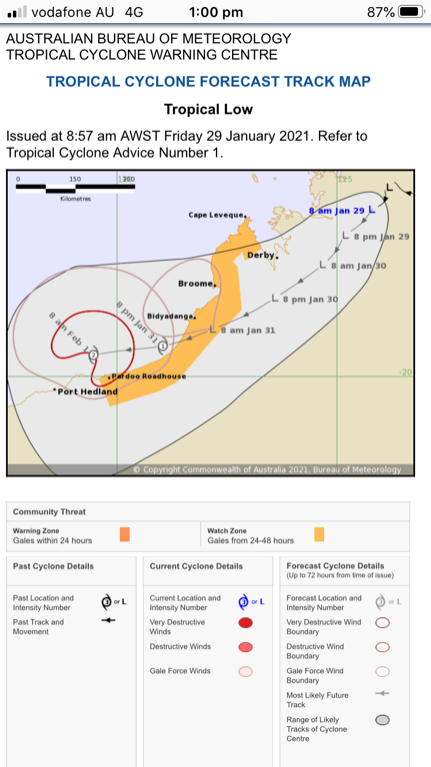
|
4 users thanked crikey for this useful post.
|
|
|
|
Rank: Advanced Member
Groups: Registered
Joined: 21/08/2019(UTC) Posts: 185 Location: Ocean View Thanks: 359 times
Was thanked: 539 time(s) in 161 post(s)
|
Just as a comparison for one week time... Here is CMC's forecast chart compared to GFS' forecast chart GFS - 4th Feb - 10pm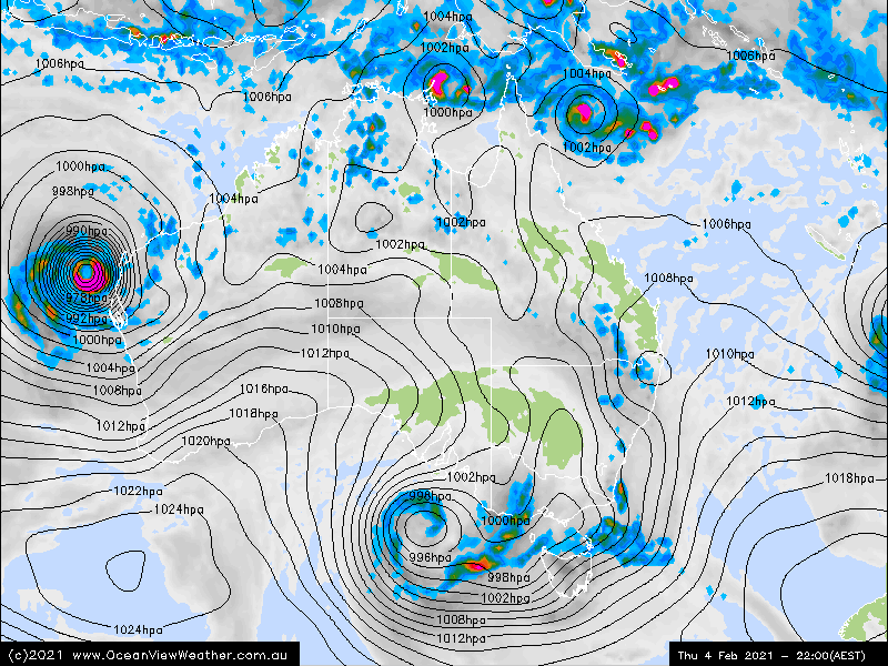 CMC - 4th Feb - 10pm CMC - 4th Feb - 10pm
|
5 users thanked Pabloako for this useful post.
|
|
|
|
Rank: Advanced Member
Groups: Registered
Joined: 24/08/2019(UTC) Posts: 292 Location: Country Victorian Thanks: 580 times
Was thanked: 503 time(s) in 194 post(s)
|
Thanks Pabloako for some alternative forecasts from other models. Very interesting 😄 ACCESS g has a tropical low up west of the gulf next Saturday ( 6 days time). I thought to check surface windstreams in the greater Asia region to see if the monsoon indeed is still active. The answer is yes. Good cross equatorial. There is every chance for some new tropical lows to spin up if we get some strong High pressure passing through as well. 
|
1 user thanked crikey for this useful post.
|
|
|
|
Rank: Advanced Member
Groups: Registered
Joined: 5/03/2020(UTC) Posts: 63 Location: el arish Was thanked: 34 time(s) in 20 post(s)
|
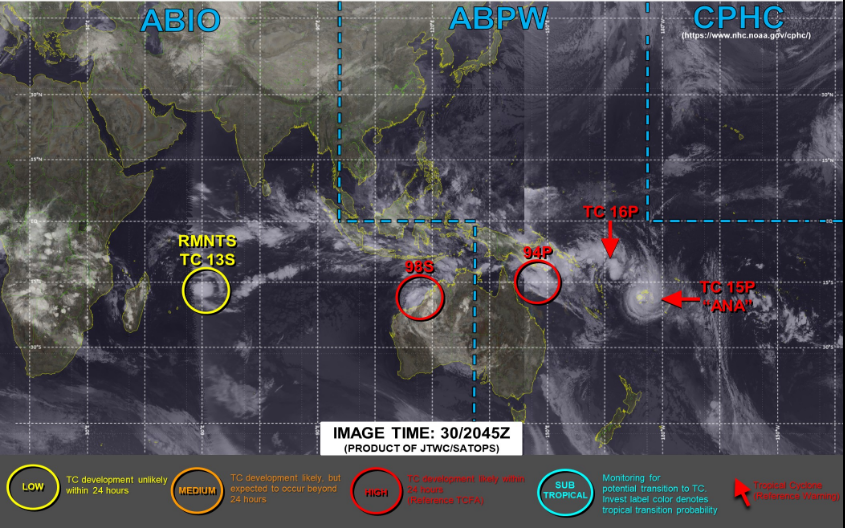 Looks pretty active out there at the moment, look how far 13s has travelled, it is one of the systems that formed of the WA coast around the same time as Kimi. One thing i have noticed so far this season is that most cyclones have been low end systems (i am sure that will change) most have only been cat 1-2 systems.
|
5 users thanked @_yassified_shak for this useful post.
|
|
|
|
Rank: Advanced Member
Groups: Registered
Joined: 24/08/2019(UTC) Posts: 292 Location: Country Victorian Thanks: 580 times
Was thanked: 503 time(s) in 194 post(s)
|
Thanks yasi ‘ for that snap of SH. Good find!
|
1 user thanked crikey for this useful post.
|
|
|
|
Rank: Advanced Member
Groups: Registered
Joined: 24/08/2019(UTC) Posts: 292 Location: Country Victorian Thanks: 580 times
Was thanked: 503 time(s) in 194 post(s)
|
|
1 user thanked crikey for this useful post.
|
|
|
|
Forum Jump
You cannot post new topics in this forum.
You cannot reply to topics in this forum.
You cannot delete your posts in this forum.
You cannot edit your posts in this forum.
You cannot create polls in this forum.
You cannot vote in polls in this forum.
Important Information:
The Weather Forum uses cookies. By continuing to browse this site, you are agreeing to our use of cookies.
More Details
Close
