Weather Forum
»
Australia Weather
»
SEQ and NE NSW
»
SE QLD and NE NSW - Day to Day Weather
Rank: Advanced Member
Groups: Registered
Joined: 2/09/2019(UTC) Posts: 105  Location: Brisbane Thanks: 145 times
Was thanked: 561 time(s) in 103 post(s)
|
Originally Posted by: CantSpellNarangba  That's brilliant Ken. Thank you for the images and thank you for using my locations!
With those chances, I don't think I would put money on it for Tuesday. Later in the week seems promising and I hope the German's are correct!
Thanks for sharing your knowledge. Glad it helps :)
|
 4 users thanked Ken for this useful post.
|
|
|
|
Rank: Advanced Member
Groups: Registered
Joined: 25/08/2019(UTC) Posts: 1,839 Location: Ferny Grove Thanks: 985 times
Was thanked: 856 time(s) in 419 post(s)
|
|
|
2 users thanked Falling_Droplet for this useful post.
|
|
|
|
Rank: Advanced Member
Groups: Registered
Joined: 21/08/2019(UTC) Posts: 182 Location: Wynnum North Thanks: 656 times
Was thanked: 381 time(s) in 167 post(s)
|
WYNNUM NORTH ( 27.4S 153.2E ) - WEATHER
DATE....6 OCT 2019 TIME....0730
CURRENT TEMPERATURE...19.0C
CURRENT HUMIDITY........76%
CURRENT DEW POINT.......14C
CURRENT WIND DIR/SPEED...S 4Kph
CURRENT VISIBILITY.....25KM
CURRENT MSL PRESSURE...1022.2Hpa
CURRENT CLOUD..........6/8 Sc
CURRENT WEATHER......Haze
RAIN SINCE 0900 SATURDAY..0.0mm
SUMMARY LAST 24 HOURS
YESTERDAY'S MAX TEMP. .......26.8C
THIS MORNING'S MIN TEMP......14.9C
PAST 24 HOURS TEMP ANOMALY..-0.05C
THIS MORNING'S GRASS MIN.....13.2C
AVERAGE 24 HOUR DEW POINT......16C
AVERAGE 24 HOUR MSLP........1020.5Hpa
MAX WIND GUST LAST 24 HOURS....SE 50Kph at 1541
PAST 24 HR SIGNIFICANT WEATHER..Haze developed Saturday afternoon with dry SE change. |
Wyn Nth 2020-Jan165, |
2 users thanked retired weather man for this useful post.
|
|
|
|
Rank: Advanced Member
Groups: Registered
Joined: 25/08/2019(UTC) Posts: 1,839 Location: Ferny Grove Thanks: 985 times
Was thanked: 856 time(s) in 419 post(s)
|
Ferny Grove Weather
Date: 6 Oct 2019
Time: 7:50 AM
Min Temp since 9am yesterday: 14.6 C
Max Temp since 9am yesterday: 32.4 C
Min Ground Temp: 12.9 C
Rain since 9am yesterday: 0 mm
Temperature: 19.8 C
Relative Humidity: 61 %
Dew Point: 12 C
MSL Pressure: 1022 hPa
Wind Speed: 3 kph - light air
Wind Direction: SW
Present Weather: State of sky generally unchanged during preceding hour
Visibility: 20km to 39km - Very Good Visibility
Cloud Cover: 5/8
Ground State: Ground dry
Notes of yesterday weather - 5/10/19: A sunny morning and partly cloudy in afternoon. Ci clouds during the morning and cu clouds developing from middle of the day. A warm day with the maximum temperature reached with a wind change. A brief and temporary fall in temperature at 10:30 am. Near average dew point early falling slowly, before remaining near average and rose during the early morning and fell slowly from the mid morning. Later in the morning the dew point fell and became moderately low, before sharply rising at 12:30 pm with the wind change and temporarily rose to near average with some S winds in the late morning. After the wind change the dew point was near average with the dew point rising slowly in the afternoon, slowly falling later in the afternoon and stable in the evening. Moderately low relative humidity and rose quickly following the wind change with a temporary rise in the late morning. Light SSE to ENE winds developing from mid morning, S to SE in the late morning, E to SE wind change from 12:30 pm and E to NE in the evening before becoming calm.
Today: Near average dew point which fell slowly in early hours of today and have been slowly rising since sunrise. Moderately low relative humidity. Calm winds have become light W to SW winds in the last hour. |
|
3 users thanked Falling_Droplet for this useful post.
|
|
|
|
Rank: Advanced Member
Groups: Registered
Joined: 13/09/2019(UTC)
Posts: 118
Location: Caboolture (the next Las Vegas!)
Thanks: 215 times
Was thanked: 297 time(s) in 100 post(s)
|
BOM forecast for Brisbane isn't looking too pleasant on Tuesday. A dry storm won't be very good in the areas that didn't get any rain last week. 
|
4 users thanked DelBoy for this useful post.
|
|
|
|
Rank: Advanced Member
Groups: Registered
Joined: 25/08/2019(UTC) Posts: 1,839 Location: Ferny Grove Thanks: 985 times
Was thanked: 856 time(s) in 419 post(s)
|
The temperature was a little variable today with the maximum temperature near average. Near average dew point and relative humidity today. The dew point slowly rose today and have been stable for the last 6 hours. Mostly light E to NE winds today, N to NE since 8 pm and have become calm in the last 30 minutes. |
|
4 users thanked Falling_Droplet for this useful post.
|
|
|
|
Rank: Advanced Member
Groups: Registered
Joined: 23/08/2019(UTC) Posts: 155 Location: Narangba Thanks: 280 times
Was thanked: 442 time(s) in 136 post(s)
|
Originally Posted by: DelBoy BOM forecast for Brisbane isn't looking too pleasant on Tuesday. A dry storm won't be very good in the areas that didn't get any rain last week.
Yes, not looking too good for the fire rating on Tuesday. https://mobile.abc.net.a...fire-conditions/11575298Southern Queensland weather forecast to bring severe fire danger and 40-degree heatwaveA wave of dangerous severe fire weather is about to hit southern Queensland with the Bureau of Meteorology (BOM) forecasting heatwave conditions as temperatures soar. The BOM said tomorrow's public holiday and Tuesday would be the hottest days with very dry, windy conditions. Gusts of over 50 kilometres an hour are expected to wreak havoc over the south-east region with 15 fires already burning, three in rugged and difficult terrain. Ipswich and the Lockyer Valley will be among the regions most at risk tomorrow. There are also severe fire dangers listed for the Darling Downs, Granite Belt, Maranona and Warrego. On Tuesday, the hazardous conditions will stretch to Blackwater, Taroom, Gayndah and in the Central West around Winton and Julia Creek.
|
3 users thanked CantSpellNarangba for this useful post.
|
|
|
|
Rank: Advanced Member
Groups: Registered
Joined: 24/08/2019(UTC) Posts: 292 Location: Country Victorian Thanks: 580 times
Was thanked: 503 time(s) in 194 post(s)
|
Hi 'guys' . Doing a bit of nomading atm. Travelling and camping. Good to check in and read the updates. So thanks.
ACC g has another tropical dip in isobars this friday the 11th oct The precip' signal is medium .
ACC suggests a closed off shore ECL may form on the weekend. Maybe someone would start a new thread for this . looks interesting event.
source http://www.bom.gov.au/au...harts/viewer/index.shtml
|
3 users thanked crikey for this useful post.
|
|
|
|
Rank: Advanced Member
Groups: Registered
Joined: 2/09/2019(UTC) Posts: 105 Location: Brisbane Thanks: 145 times
Was thanked: 561 time(s) in 103 post(s)
|
 Originally Posted by: crikey Hi 'guys' . Doing a bit of nomading atm. Travelling and camping. Good to check in and read the updates. So thanks.
ACC g has another tropical dip in isobars this friday the 11th oct The precip' signal is medium .
ACC suggests a closed off shore ECL may form on the weekend. Maybe someone would start a new thread for this . looks interesting event.
source http://www.bom.gov.au/au...harts/viewer/index.shtml EC's also suggesting a multicentred ECL to form around that time as well. It still looks like the better rainfall amounts will be along the NSW coast in the onshore flow on the southern flank of that system. But once it forms, most areas to its north (including us) should see an end to significant rainfall as the drier SW flow wraps up around its rear flank. Until the flow becomes onshore again of course. EC 10-day accumulations above.
Edited by user Monday, 7 October 2019 6:49:39 AM(UTC)
| Reason: Not specified
|
7 users thanked Ken for this useful post.
|
|
|
|
Rank: Advanced Member
Groups: Registered
Joined: 21/08/2019(UTC) Posts: 182 Location: Wynnum North Thanks: 656 times
Was thanked: 381 time(s) in 167 post(s)
|
WYNNUM NORTH ( 27.4S 153.2E ) - WEATHER
DATE....7 OCT 2019 TIME....0725
CURRENT TEMPERATURE...20.4C
CURRENT HUMIDITY........84%
CURRENT DEW POINT.......18C
CURRENT WIND DIR/SPEED...NNW 16Kph
CURRENT VISIBILITY.....30KM
CURRENT MSL PRESSURE...1016.8Hpa
CURRENT CLOUD..........1/8 Ci
CURRENT WEATHER......No significant weather
RAIN SINCE 0900 SUNDAY..0.0mm
SUMMARY LAST 24 HOURS
YESTERDAY'S MAX TEMP. .......25.6C
THIS MORNING'S MIN TEMP......16.3C
PAST 24 HOURS TEMP ANOMALY..+0.05C
THIS MORNING'S GRASS MIN.....14.1C
AVERAGE 24 HOUR DEW POINT......17C
AVERAGE 24 HOUR MSLP........1018.9Hpa
MAX WIND GUST LAST 24 HOURS....NE 33Kph at 1626
PAST 24 HR SIGNIFICANT WEATHER..No significant weather.. |
Wyn Nth 2020-Jan165, |
1 user thanked retired weather man for this useful post.
|
|
|
|
Rank: Advanced Member
Groups: Registered
Joined: 7/09/2019(UTC) Posts: 67 Location: Brisbane Thanks: 113 times
Was thanked: 207 time(s) in 61 post(s)
|
Wow. What a great image and lovely to see such detail. Fingers crossed today and tomorrow are uneventful and then the rain later this week.
|
4 users thanked SatMan for this useful post.
|
|
|
|
Rank: Advanced Member
Groups: Registered
Joined: 25/08/2019(UTC) Posts: 1,839 Location: Ferny Grove Thanks: 985 times
Was thanked: 856 time(s) in 419 post(s)
|
Ferny Grove Weather
Date: 7 Oct 2019
Time: 10:10 AM
Min Temp since 9am yesterday: 14.2 C
Max Temp since 9am yesterday: 28.6 C
Min Ground Temp: 12.9 C
Rain since 9am yesterday: 0 mm
Temperature: 29.6 C
Relative Humidity: 42 %
Dew Point: 15.3 C
MSL Pressure: 1014.8 hPa
Wind Speed: 5 kph - light air
Wind Direction: W
Present Weather: No cloud development observed
Visibility: 20km to 39km - Very Good Visibility
Cloud Cover: 0/8
Ground State: Ground dry
Notes of yesterday weather - 6/10/19: Near average dew point fell slowly in the early hours before slowly rising through to late afternoon, became stable and fell slowly in the late evening. The temperature was a little variable in the morning and afternoon. Relative humidity was moderately low early in the day and near average for the rest of the day. Relative humidity was a little variable in the morning and afternoon. Light and variable winds at times early before some WSW to SW winds in the early morning and then ESE to NNE winds during the morning. Winds were light E to NE from late morning, ENE to NE in late afternoon, N to NE in the evening and became calm in the late evening.
Today: Dew point have been near average and falling slowly before rising after sunrise, became moderately high at 8am and have since fallen to near average. Near average relative humidity overnight have become moderately low this morning. After calm winds early today, winds have been N to NE this morning becoming ENE to SE with some E to NE winds. |
|
3 users thanked Falling_Droplet for this useful post.
|
|
|
|
Rank: Advanced Member
Groups: Registered
Joined: 25/08/2019(UTC) Posts: 1,839 Location: Ferny Grove Thanks: 985 times
Was thanked: 856 time(s) in 419 post(s)
|
Fire Weather Warning for SE Coast tomorrow:
Fire Weather Warning
for the Central Highlands and Coalfields, Maranoa and Warrego, Darling Downs and Granite Belt, Wide Bay and Burnett and Southeast Coast forecast districts
Issued at 10:17 am EST on Monday 7 October 2019.
Weather Situation
Severe fire dangers are forecast to affect the Darling Downs and Granite Belt and Maranoa and Warrego districts today and Tuesday, with the potential for localised Extreme conditions in southern forested parts of these districts.
Severe fire dangers are also expected to affect the Central Highlands and Coalfields, Wide Bay and Burnett and Southeast Coasts on Tuesday.
Fresh and gusty westerly winds are expected to bring hot and dry conditions across the warning area today, ahead of a cold front that will move into the Maranoa and Warrego late this evening. Winds behind the front will turn southwesterly, remaining fresh, gusty and dry with cooler temperatures.
For the rest of Monday 7 October:
Severe Fire Danger in the following forecast districts:
Maranoa and Warrego and Darling Downs and Granite Belt
For Tuesday 8 October:
Severe Fire Danger is forecast for the following forecast districts:
Central Highlands and Coalfields, Darling Downs and Granite Belt, Wide Bay and Burnett and Southeast Coast |
|
3 users thanked Falling_Droplet for this useful post.
|
|
|
|
Rank: Advanced Member
Groups: Registered
Joined: 21/08/2019(UTC) Posts: 185 Location: Ocean View Thanks: 359 times
Was thanked: 539 time(s) in 161 post(s)
|
It has been a warm day up here today and maxing out at 32 degrees. Luckily for the fire rating the humidity stayed mostly above 50%.
|
2 users thanked Pabloako for this useful post.
|
|
|
|
Rank: Advanced Member
Groups: Registered
Joined: 26/08/2019(UTC) Posts: 32 Location: Bardon Thanks: 96 times
Was thanked: 138 time(s) in 32 post(s)
|
Warm here as well, although we didn't get anywhere near the 34 degress predicted. Maximum was 30.8 just after 11 am. Suspect the NE see breeze saved us. Hope it saves us again tomorrow!
Maximums out west around Amberley closer to the predicted 40, Amberley 39.7, Gatton 40.9, Beaudesert 37.6.
Few thunderstorms and showers around this afternoon, although most south of the border. I couldn't find any rainfall recorded since 0900 this morning.
Greg
|
5 users thanked Greg for this useful post.
|
|
|
|
Rank: Advanced Member
Groups: Registered
Joined: 23/08/2019(UTC) Posts: 155 Location: Narangba Thanks: 280 times
Was thanked: 442 time(s) in 136 post(s)
|
It maxed out at 34.2 degrees here today, but the humidity was quite yuckie and uncomfortable at times.
The sea breeze did manage to get here at one point, which had a lovely cooling impact.
Time to water the plants.
|
1 user thanked CantSpellNarangba for this useful post.
|
|
|
|
Rank: Advanced Member
Groups: Registered
Joined: 23/08/2019(UTC) Posts: 155 Location: Narangba Thanks: 280 times
Was thanked: 442 time(s) in 136 post(s)
|
Following on from Ken's post above, WZ are backing that up too. I love the word "Heavy"  A trough looks to bring rain and showers over coastal QLD and northern NSW, heavy in parts, with a few storms possible. A front approaching southwest WA should cause showers to develop. Onshore winds should produce showers over VIC and TAS. Issued Monday 11:11 EDT Edited by user Monday, 7 October 2019 6:06:22 PM(UTC)
| Reason: Keyboard v brain fight
|
1 user thanked CantSpellNarangba for this useful post.
|
|
|
|
Rank: Advanced Member
Groups: Registered
Joined: 13/09/2019(UTC)
Posts: 118
Location: Caboolture (the next Las Vegas!)
Thanks: 215 times
Was thanked: 297 time(s) in 100 post(s)
|
Originally Posted by: Greg Warm here as well, although we didn't get anywhere near the 34 degress predicted. Maximum was 30.8 just after 11 am. Suspect the NE see breeze saved us. Hope it saves us again tomorrow!
Maximums out west around Amberley closer to the predicted 40, Amberley 39.7, Gatton 40.9, Beaudesert 37.6.
Few thunderstorms and showers around this afternoon, although most south of the border. I couldn't find any rainfall recorded since 0900 this morning.
Greg
Lucky you Greg. It got the 34 here today and it was horrible.
|
1 user thanked DelBoy for this useful post.
|
|
|
|
Rank: Advanced Member
Groups: Registered
Joined: 2/09/2019(UTC) Posts: 105 Location: Brisbane Thanks: 145 times
Was thanked: 561 time(s) in 103 post(s)
|
  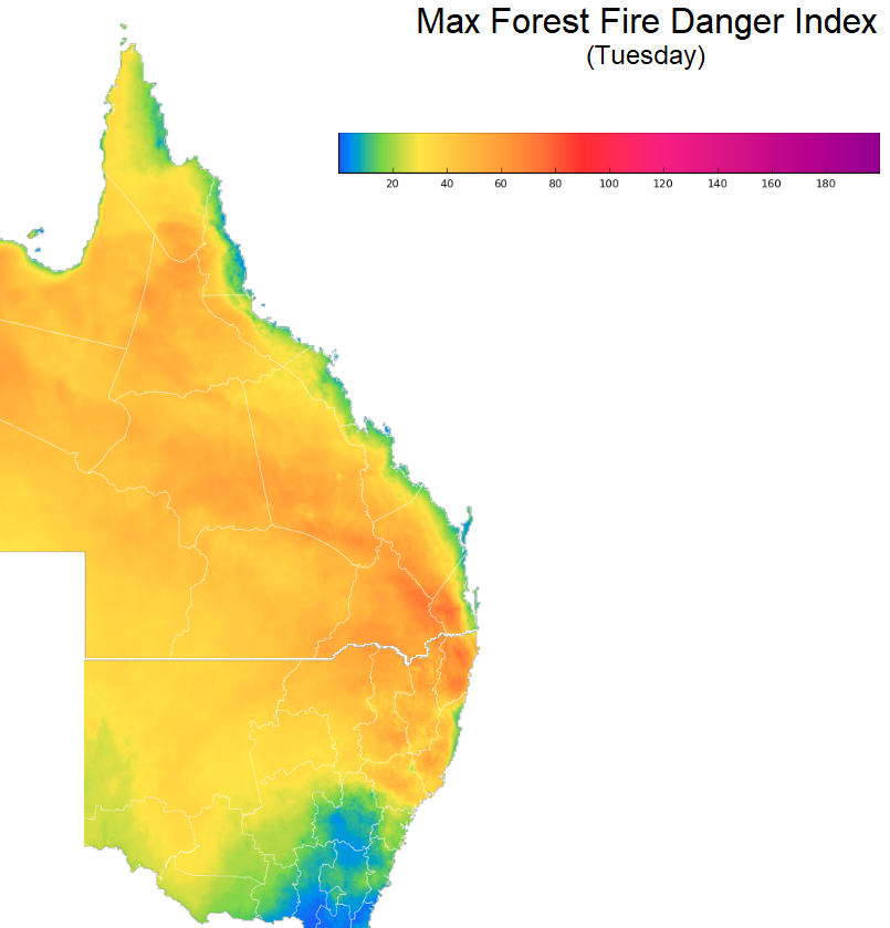 1st image above - Pretty good consensus among various models for the increase in rainfall towards the end of the week/early weekend for Brisbane. CMC (red) is very often the highest outlier of the bunch though. 2nd image - Delta max temp forecast from Tue to Wed. Will be most welcome indeed. 3rd image - Max forest fire danger index values (one of the components that make up the fire danger ratings but not the only one) via the Bureau. Values of 50 to 75 are considered severe and 75 and above are considered extreme. Note though that the values are pretty sensitive to various factors and even a slight increase in wind speed can greatly increase the values.
|
5 users thanked Ken for this useful post.
|
|
|
|
Rank: Advanced Member
Groups: Registered
Joined: 7/09/2019(UTC) Posts: 67 Location: Brisbane Thanks: 113 times
Was thanked: 207 time(s) in 61 post(s)
|
I love the delta graph. What a great way of showing the effect of a cooler change. 
|
2 users thanked SatMan for this useful post.
|
|
|
|
Weather Forum
»
Australia Weather
»
SEQ and NE NSW
»
SE QLD and NE NSW - Day to Day Weather
Forum Jump
You cannot post new topics in this forum.
You cannot reply to topics in this forum.
You cannot delete your posts in this forum.
You cannot edit your posts in this forum.
You cannot create polls in this forum.
You cannot vote in polls in this forum.
Important Information:
The Weather Forum uses cookies. By continuing to browse this site, you are agreeing to our use of cookies.
More Details
Close
