Weather Forum
»
Australia Weather
»
SEQ and NE NSW
»
SE QLD and NE NSW - Day to Day Weather
Rank: Advanced Member
Groups: Registered
Joined: 21/08/2019(UTC) Posts: 185  Location: Ocean View Thanks: 359 times
Was thanked: 539 time(s) in 161 post(s)
|
Thanks for pointing that out MegaMatch and CSN (I still can't spell it)! This weekend is looking like it will be hot hot hot! One piece of software I use on my weather site is called WXSim, which is great program that imports data from various sources, including GFS and then "mashes" (sorry, unscientific term) with the data from my weather station and it makes pretty accurate forecast. It creates a bunch of CSV and other files that I then display as the forecast. A part of this software is below is a screenshot for the next 9 days. - Thin red line is what GFS forecasts the temperature to be and the thick red line is what the software forecast for my exact location temperature (400m altitude)
- Thin blue line is what GFS forecasts dewpoint to be and the thick blue line is what the software forecast for my exact location
- Purple line on Sunday and Wednesday is cloud cover percentage
- The bar graph at the bottom is precipitation
It is showing precipitation on Tuesday evening and into Wednesday.  Edited by user Thursday, 3 October 2019 1:40:10 PM(UTC)
| Reason: I can't spell
|
 3 users thanked Pabloako for this useful post.
|
|
|
|
Rank: Advanced Member
Groups: Registered
Joined: 25/08/2019(UTC) Posts: 1,839 Location: Ferny Grove Thanks: 985 times
Was thanked: 856 time(s) in 419 post(s)
|
Sunny day today with near average maximum temperature. Dew point fell during the morning and became low, rising since the afternoon and is currently moderately low while falling slowly. Relative humidity has been moderately low. Winds have been variable in the morning, mostly E to NE since the afternoon and N to NNE in the last few hours. |
|
3 users thanked Falling_Droplet for this useful post.
|
|
|
|
Rank: Advanced Member
Groups: Registered
Joined: 21/08/2019(UTC) Posts: 185 Location: Ocean View Thanks: 359 times
Was thanked: 539 time(s) in 161 post(s)
|
Not a drop showing up on WATL for Tuesday. 
|
3 users thanked Pabloako for this useful post.
|
|
|
|
Rank: Advanced Member
Groups: Registered
Joined: 2/09/2019(UTC) Posts: 105 Location: Brisbane Thanks: 145 times
Was thanked: 561 time(s) in 103 post(s)
|
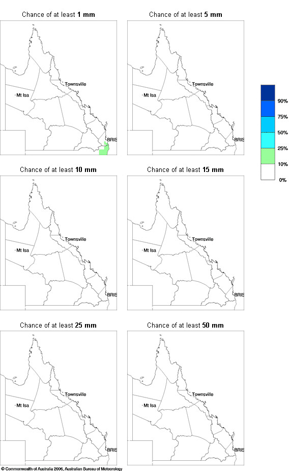 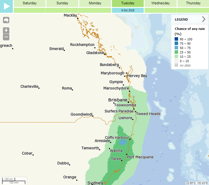 Originally Posted by: Pabloako  Not a drop showing up on WATL for Tuesday. It's probably worth noting that the WATL maps won't show anything below 1mm (the bottom of its colour scale) so it can sometimes not display patchy low-rainfall precip. If you look at its chance of rain maps, you can see a small percentage of its range of models are currently extending a bit of precip up into southern SE QLD on Tuesday (between 10pm Mon and 10pm Tue). In these cases, it's probably better to look at the chance of any rainfall (which use a threshold of 0.2mm or greater) maps such as the one from Meteye for Tuesday (midnight to midnight) - this one also has manual adjustments made to the raw model data - see first example above. The 2nd image above is the chance of any rainfall for 10pm Mon to 10pm Tue generated by the last 6 runs of GFS combined with the US Navy ensemble. If there is any precip in SE QLD on Tuesday, it'll probably be in the form of some very low-rainfall shower or thunderstorm activity (there's a distinct possibility that some storms may become severe next week).
|
4 users thanked Ken for this useful post.
|
|
|
|
Rank: Advanced Member
Groups: Registered
Joined: 21/08/2019(UTC) Posts: 182 Location: Wynnum North Thanks: 656 times
Was thanked: 381 time(s) in 167 post(s)
|
WYNNUM NORTH ( 27.4S 153.2E ) - WEATHER
DATE....4 OCT 2019 TIME....0715
CURRENT TEMPERATURE...16.8C
CURRENT HUMIDITY........78%
CURRENT DEW POINT.......13C
CURRENT WIND DIR/SPEED...W 9Kph
CURRENT VISIBILITY.....30KM
CURRENT MSL PRESSURE...1025.2Hpa
CURRENT CLOUD..........1/8 Ac
CURRENT WEATHER......No significant weather
RAIN SINCE 0900 THURSDAY..0.0mm
SUMMARY LAST 24 HOURS
YESTERDAY'S MAX TEMP. .......24.2C
THIS MORNING'S MIN TEMP......10.9C
PAST 24 HOURS TEMP ANOMALY..-3.35C
THIS MORNING'S GRASS MIN.....10.1C
AVERAGE 24 HOUR DEW POINT......12C
AVERAGE 24 HOUR MSLP........1025.2Hpa
MAX WIND GUST LAST 24 HOURS....N 33Kph at 1218
PAST 24 HR SIGNIFICANT WEATHER..No significant weather. |
Wyn Nth 2020-Jan165, |
2 users thanked retired weather man for this useful post.
|
|
|
|
Rank: Advanced Member
Groups: Registered
Joined: 25/08/2019(UTC) Posts: 1,839 Location: Ferny Grove Thanks: 985 times
Was thanked: 856 time(s) in 419 post(s)
|
Ferny Grove Weather
Date: 4 Oct 2019
Time: 7:45 AM
Min Temp since 9am yesterday: 10.7 C
Max Temp since 9am yesterday: 27.4 C
Min Ground Temp: 9 C
Rain since 9am yesterday: 0 mm
Temperature: 18.6 C
Relative Humidity: 59 %
Dew Point: 10.4 C
MSL Pressure: 1024.6 hPa
Wind Speed: 3 kph - light air
Wind Direction: SSE
Present Weather: Clouds generally dissolving or becoming less developed during the preceding hour
Visibility: 20km to 39km - Very Good Visibility
Cloud Cover: 0/8
Ground State: Ground dry
Notes of yesterday weather - 3/10/19: Fine. Some cu clouds clearing in the early morning to a sunny day. A cold morning. Dew point was moderately low while falling early in the day before rising during the early morning to near average, before falling through the morning and afternoon and was moderately low. In the early afternoon the dew point rose to near average for the rest of the afternoon but was stable in the mid afternoon before slowly falling in the evening while remaining near average. Moderately low relative humidity. Light and variable winds at times in the early hours, W to SSE in the early morning and generally NW to NE winds with some SE to NE winds for the rest of the morning. E to NE winds in the afternoon, ENE to NE later in the afternoon, and NNE to NNW in the evening before becoming calm later in the evening.
Today: A cool morning. Dew point have been falling slowly, became moderately low and have been rising in the last two hours and is now near average. Moderately low relative humidity today. Winds have been calm with light and variable winds starting in the last half-hour.
|
|
2 users thanked Falling_Droplet for this useful post.
|
|
|
|
Rank: Advanced Member
Groups: Registered
Joined: 2/09/2019(UTC) Posts: 105 Location: Brisbane Thanks: 145 times
Was thanked: 561 time(s) in 103 post(s)
|
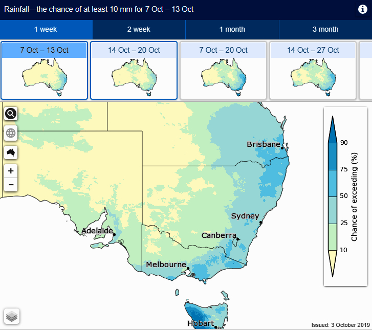 Next week looks like a case of the good old "how far north will the upper trough arc up?" question re how much or little rainfall we'll get here in SE QLD later next week. Severe storms look a distinct possibility though due to the shear (as long as things don't become a cloudy rainy mess too early). My usual instinct is to favour the NSW coast for the best rainfall whenever the setup involves "southern type" systems such as the upcoming front and upper trough with SE QLD getting a toned down version of it... but every setup has differences so I'd be reluctant to pigeonhole this setup into that category atm. If the upper trough swings up far enough into the eastern interior of QLD and stays strong, it'd put us in the broadscale upmotion zone to its east which would boost our chances of more substantial rainfall in addition to just showers/storms (this would also happen if the trough cuts off a separate low just to our west, or if a surface trough deepens just to our west as well). On the other hand, if the upper trough stays too far so south, any rainfall would be mostly convective rather than a major rain event. I saw yesterday's 00z EC had a wild bombing ECL near the NSW or southern QLD coast scenario which would probably signal the end of the event for areas to its north if it occurred (after any prior rainfall) but heavy rain and gales to its south. Meanwhile a bit of max temp uncertainty this weekend with the cooler S to SE change reaching here a more realistic possibility than it was a few days ago. Above is the latest ACCESS-S output for probabilities of exceeding 10mm between the 7th and 13th October. Regardless of whether any rainfall is sporadic showers and storms, or a more substantial rain event, the shear looks great so as long as there's storms and things don't become a cloudy rainy mess from early on, there could well be some severe storms somewhere in the region.
|
6 users thanked Ken for this useful post.
|
|
|
|
Rank: Advanced Member
Groups: Registered
Joined: 13/09/2019(UTC)
Posts: 118
Location: Caboolture (the next Las Vegas!)
Thanks: 215 times
Was thanked: 297 time(s) in 100 post(s)
|
I love your technical input and reports Ken. Very informative. Thank you. This one appears to be another "wait and see" scenarios by the looks of it. Quick curious question from me though.... Why is it that NE NSW seems to get more storm action than north of the border? Perhaps it is just me thinking this though. Edited by user Friday, 4 October 2019 3:22:27 PM(UTC)
| Reason: Not specified
|
3 users thanked DelBoy for this useful post.
|
|
|
|
Rank: Advanced Member
Groups: Registered
Joined: 13/09/2019(UTC)
Posts: 118
Location: Caboolture (the next Las Vegas!)
Thanks: 215 times
Was thanked: 297 time(s) in 100 post(s)
|
That's not good again. 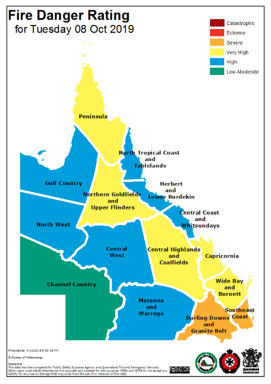
|
3 users thanked DelBoy for this useful post.
|
|
|
|
Rank: Advanced Member
Groups: Registered
Joined: 25/08/2019(UTC) Posts: 1,839 Location: Ferny Grove Thanks: 985 times
Was thanked: 856 time(s) in 419 post(s)
|
Sunny day with near average maximum temperature. Dew point have been mostly near average today and have been falling very slowly since later this afternoon. Moderately low relative humidity today. Winds were mostly E to NE today with some N to NE this morning and tonight. |
|
2 users thanked Falling_Droplet for this useful post.
|
|
|
|
Rank: Advanced Member
Groups: Registered
Joined: 21/08/2019(UTC) Posts: 182 Location: Wynnum North Thanks: 656 times
Was thanked: 381 time(s) in 167 post(s)
|
WYNNUM NORTH ( 27.4S 153.2E ) - WEATHER
DATE....5 OCT 2019 TIME....0720
CURRENT TEMPERATURE...18.1C
CURRENT HUMIDITY........77%
CURRENT DEW POINT.......14C
CURRENT WIND DIR/SPEED...WNW 4Kph
CURRENT VISIBILITY.....30KM
CURRENT MSL PRESSURE...1020.8Hpa
CURRENT CLOUD..........Nil
CURRENT WEATHER......No significant weather
RAIN SINCE 0900 FRIDAY..0.0mm
SUMMARY LAST 24 HOURS
YESTERDAY'S MAX TEMP. .......25.3C
THIS MORNING'S MIN TEMP......13.0C
PAST 24 HOURS TEMP ANOMALY..-1.75C
THIS MORNING'S GRASS MIN.....12.6C
AVERAGE 24 HOUR DEW POINT......14C
AVERAGE 24 HOUR MSLP........1022.3Hpa
MAX WIND GUST LAST 24 HOURS....N 35Kph at 1905
PAST 24 HR SIGNIFICANT WEATHER..No significant weather. |
Wyn Nth 2020-Jan165, |
2 users thanked retired weather man for this useful post.
|
|
|
|
Rank: Member
Groups: Registered
Joined: 17/08/2019(UTC) Posts: 11 Location: Brisbane Was thanked: 26 time(s) in 9 post(s)
|
Originally Posted by: DelBoy That's not good again. Wouldn’t be surprised if this actually moves into locally Extreme. Forest fuel loads are almost maxed, with the exception of the Caboolture area (part of the SouthEast Coast district) from the rain last week. Samford and surrounds specifically is looking the driest I’ve ever seen it.
|
3 users thanked Zuldjan for this useful post.
|
|
|
|
Rank: Advanced Member
Groups: Registered
Joined: 25/08/2019(UTC) Posts: 1,839 Location: Ferny Grove Thanks: 985 times
Was thanked: 856 time(s) in 419 post(s)
|
Ferny Grove Weather
Date: 5 Oct 2019
Time: 9:25 AM
Min Temp since 9am yesterday: 11.4 C
Max Temp since 9am yesterday: 28.1 C
Min Ground Temp: 9.4 C
Rain since 9am yesterday: 0 mm
Temperature: 26.7 C
Relative Humidity: 39 %
Dew Point: 11.6 C
MSL Pressure: 1019.6 hPa
Wind Speed: 4 kph - light air
Wind Direction: ESE
Present Weather: Clouds generally forming or developing during the preceding hour
Visibility: 20km to 39km - Very Good Visibility
Cloud Cover: 0/8
Ground State: Ground dry
Notes of yesterday weather - 4/10/19: A cool morning. Moderately low and falling dew point early before rising in the early morning to near average and then fell slowly during the morning. In the afternoon the dew point rose before falling slowly from late afternoon while remaining near average. Moderately low dew point over entire day. Calm early, light and variable winds in the early morning, N to ENE winds in the morning with some E to SE winds, E to NE in the afternoon and N to ESE in the evening.
Today: Near average dew point so far today and was stable before rising for 3 hours until 8 am and have since been falling slowly. Moderately low relative humidity. Calm winds early with E to SE winds in the last 2 hours.
|
|
2 users thanked Falling_Droplet for this useful post.
|
|
|
|
Rank: Member
Groups: Registered
Joined: 17/08/2019(UTC) Posts: 11 Location: Brisbane Was thanked: 26 time(s) in 9 post(s)
|
Originally Posted by: Zuldjan Originally Posted by: DelBoy That's not good again. Wouldn’t be surprised if this actually moves into locally Extreme. Forest fuel loads are almost maxed, with the exception of the Caboolture area (part of the SouthEast Coast district) from the rain last week. Samford and surrounds specifically is looking the driest I’ve ever seen it. Further areas added to severe
|
|
|
|
|
|
Rank: Advanced Member
Groups: Registered
Joined: 23/08/2019(UTC) Posts: 155 Location: Narangba Thanks: 280 times
Was thanked: 442 time(s) in 136 post(s)
|
Bit of an "everything" kind of day here today, hot and sunny and then cloudy and at around 3pm, the wind shifted to the ENE and was pretty strong.
One thing I have noticed from my weather station is that the UV Index has taken a jump over the last few days and reaching over 8 now, so the sun is starting to have a punch to it.
WATL and some other models I have checked have given up on any rain or chance of rain to end of a very hot day on Tuesday, so a dry cool change looks like it may happen now. Winds are looking to be quite blustery on Tuesday and 36 degrees from Brizzy so not good for fires as Zuldjan said above.
Luckily I had quite a bit of rain here last week, so fire dangers should be a bit lower, however 36 degrees and wind is going to strip away any moisture.
|
2 users thanked CantSpellNarangba for this useful post.
|
|
|
|
Rank: Advanced Member
Groups: Registered
Joined: 13/09/2019(UTC)
Posts: 118
Location: Caboolture (the next Las Vegas!)
Thanks: 215 times
Was thanked: 297 time(s) in 100 post(s)
|
Yep. I am with you there CSN. Very damp at the moment from 80mm last week, but Tuesday (plus by the looks of it Monday) is going to fix that! Here is the latest fire rating from RFS/BOM for Tuesday. 
|
2 users thanked DelBoy for this useful post.
|
|
|
|
Rank: Advanced Member
Groups: Registered
Joined: 2/09/2019(UTC) Posts: 105 Location: Brisbane Thanks: 145 times
Was thanked: 561 time(s) in 103 post(s)
|
Originally Posted by: CantSpellNarangba WATL and some other models I have checked have given up on any rain or chance of rain to end of a very hot day on Tuesday, so a dry cool change looks like it may happen now. There actually are a few models that are still going for some very low rainfall amounts for locations such as Brisbane but the percentage of all the models doing that is fairly low. WATL won't show anything below 1mm so there are some times when very low rainfall showers or storms won't show up in it. Better to check the chance of any rainfall maps in that case.
|
2 users thanked Ken for this useful post.
|
|
|
|
Rank: Advanced Member
Groups: Registered
Joined: 23/08/2019(UTC) Posts: 155 Location: Narangba Thanks: 280 times
Was thanked: 442 time(s) in 136 post(s)
|
Originally Posted by: Ken Originally Posted by: CantSpellNarangba WATL and some other models I have checked have given up on any rain or chance of rain to end of a very hot day on Tuesday, so a dry cool change looks like it may happen now. There actually are a few models that are still going for some very low rainfall amounts for locations such as Brisbane but the percentage of all the models doing that is fairly low. WATL won't show anything below 1mm so there are some times when very low rainfall showers or storms won't show up in it. Better to check the chance of any rainfall maps in that case. Thanks Ken. I have just checked the chance of rainfall on WATL and it is completely white for our area. 
|
1 user thanked CantSpellNarangba for this useful post.
|
|
|
|
Rank: Advanced Member
Groups: Registered
Joined: 2/09/2019(UTC) Posts: 105 Location: Brisbane Thanks: 145 times
Was thanked: 561 time(s) in 103 post(s)
|
  Originally Posted by: CantSpellNarangba Originally Posted by: Ken Originally Posted by: CantSpellNarangba WATL and some other models I have checked have given up on any rain or chance of rain to end of a very hot day on Tuesday, so a dry cool change looks like it may happen now. There actually are a few models that are still going for some very low rainfall amounts for locations such as Brisbane but the percentage of all the models doing that is fairly low. WATL won't show anything below 1mm so there are some times when very low rainfall showers or storms won't show up in it. Better to check the chance of any rainfall maps in that case. Thanks Ken. I have just checked the chance of rainfall on WATL and it is completely white for our area. Yep it's probably because the few models that are producing precip are only producing amounts below 1mm for the most part. Above are the accumulating rainfall scenarios from a number of models for Narangba. As you can see, a few of the models are going for a bit of precip at some stage up to 10pm Tue but most of those are below 1mm and the majority of those models aren't producing anything. Also above is the Bureau's chance of any rainfall map (0.2mm or higher) for Tuesday which is the end result of raw model data with manual adjustments where deemed necessary. In any case, it's pretty academic though. Even if any showers or storms form on Tuesday, most of those would be low-rainfall ones so definitely not something to pin hopes on if you're wanting any worthwhile rain amounts.
|
3 users thanked Ken for this useful post.
|
|
|
|
Rank: Advanced Member
Groups: Registered
Joined: 23/08/2019(UTC) Posts: 155 Location: Narangba Thanks: 280 times
Was thanked: 442 time(s) in 136 post(s)
|
That's brilliant Ken. Thank you for the images and thank you for using my locations!
With those chances, I don't think I would put money on it for Tuesday. Later in the week seems promising and I hope the German's are correct!
Thanks for sharing your knowledge.
|
2 users thanked CantSpellNarangba for this useful post.
|
|
|
|
Weather Forum
»
Australia Weather
»
SEQ and NE NSW
»
SE QLD and NE NSW - Day to Day Weather
Forum Jump
You cannot post new topics in this forum.
You cannot reply to topics in this forum.
You cannot delete your posts in this forum.
You cannot edit your posts in this forum.
You cannot create polls in this forum.
You cannot vote in polls in this forum.
Important Information:
The Weather Forum uses cookies. By continuing to browse this site, you are agreeing to our use of cookies.
More Details
Close
