Weather Forum
»
Australia Weather
»
SEQ and NE NSW
»
SE QLD and NE NSW - Day to Day Weather
Rank: Advanced Member
Groups: Registered
Joined: 24/08/2019(UTC) Posts: 292  Location: Country Victorian Thanks: 580 times
Was thanked: 503 time(s) in 194 post(s)
|
CPN 'According to GFS on OceanViewWeather, they are going for a drop of rain on Tuesday.... What's everyone's thoughts on this?'The troughing you see on tuesday is a continuation of this stalled trough we have been having over the past days. Except a high pressure cell has pushed the trough, tropical dip in isobars further north. I think there is going to be something to talk about but looking at the GFS forecast you posted and comparing ACC r. I would say there is some dispute regarding position of the synoptic features. Which is going to be very important here. But its that sort of divergence which often makes a days weather watching even more interesting. The thread l made only goes up to tomorrow so it is up to you 'guys' where you want to continue. ? Edited by user Sunday, 29 September 2019 1:56:48 PM(UTC)
| Reason: Not specified
|
 3 users thanked crikey for this useful post.
|
|
|
|
Rank: Advanced Member
Groups: Registered
Joined: 24/08/2019(UTC) Posts: 292 Location: Country Victorian Thanks: 580 times
Was thanked: 503 time(s) in 194 post(s)
|
Thanks for the news KEN on the ACCESS upgrade. I guess it had to happen sooner or later.
I will certainly know when the changeover happens because l watch the model closely as you know.
I do agree re ACC r weakness on coastal diagnosis on rain bands coming over the ranges.
I also have learnt that ACCESS is not configured for storm potential and just seems more attuned to lifted index convection.
I also am aware that ACC cannot accurately resolve mslp out at sea during big depressions and cyclones.
ACC g also shows higher rainfall potential than ACC r. So all in all it will be interesting to see how the new upgrade goes.
I think l remember MEGA saying he didn't like the GFS upgrade.So sill look on with interest
|
3 users thanked crikey for this useful post.
|
|
|
|
Rank: Advanced Member
Groups: Registered
Joined: 2/09/2019(UTC) Posts: 105 Location: Brisbane Thanks: 145 times
Was thanked: 561 time(s) in 103 post(s)
|
Originally Posted by: crikey  Thanks for the news KEN on the ACCESS upgrade. I guess it had to happen sooner or later.
I will certainly know when the changeover happens because l watch the model closely as you know.
I do agree re ACC r weakness on coastal diagnosis on rain bands coming over the ranges.
I also have learnt that ACCESS is not configured for storm potential and just seems more attuned to lifted index convection.
I also am aware that ACC cannot accurately resolve mslp out at sea during big depressions and cyclones.
ACC g also shows higher rainfall potential than ACC r. So all in all it will be interesting to see how the new upgrade goes.
I think l remember MEGA saying he didn't like the GFS upgrade.So sill look on with interest
Nah all models are designed to simulate thunderstorm activity including ACCESS-R. Just that they do it in similar buy slightly different ways. ACCESS-R doesn’t use LI just to simulate convection. It, like most other models, uses physics and thermodynamics for that. Also, the precip on the ACCESS charts on the Bureau’s website are heavily interpolated/smoothed so you sometimes won’t see the finer details.
|
4 users thanked Ken for this useful post.
|
|
|
|
Rank: Advanced Member
Groups: Registered
Joined: 24/08/2019(UTC) Posts: 292 Location: Country Victorian Thanks: 580 times
Was thanked: 503 time(s) in 194 post(s)
|
Originally Posted by: Ken Originally Posted by: crikey Thanks for the news KEN on the ACCESS upgrade. I guess it had to happen sooner or later.
I will certainly know when the changeover happens because l watch the model closely as you know.
I do agree re ACC r weakness on coastal diagnosis on rain bands coming over the ranges.
I also have learnt that ACCESS is not configured for storm potential and just seems more attuned to lifted index convection.
I also am aware that ACC cannot accurately resolve mslp out at sea during big depressions and cyclones.
ACC g also shows higher rainfall potential than ACC r. So all in all it will be interesting to see how the new upgrade goes.
I think l remember MEGA saying he didn't like the GFS upgrade.So sill look on with interest
Nah all models are designed to simulate thunderstorm activity including ACCESS-R. Just that they do it in similar buy slightly different ways. ACCESS-R doesn’t use LI just to simulate convection. It, like most other models, uses physics and thermodynamics for that. Also, the precip on the ACCESS charts on the Bureau’s website are heavily interpolated/smoothed so you sometimes won’t see the finer details. Ok. Thanks for that.
Would l be right in saying models generally do better with stronger systems.Rather than marginal systems.?
|
4 users thanked crikey for this useful post.
|
|
|
|
Rank: Advanced Member
Groups: Registered
Joined: 21/08/2019(UTC) Posts: 182 Location: Wynnum North Thanks: 656 times
Was thanked: 381 time(s) in 167 post(s)
|
WYNNUM NORTH ( 27.4S 153.2E ) - WEATHER
DATE....30 SEP 2019 TIME....0740
CURRENT TEMPERATURE...19.9C
CURRENT HUMIDITY........77%
CURRENT DEW POINT.......16C
CURRENT WIND DIR/SPEED...S 6Kph
CURRENT VISIBILITY.....20KM
CURRENT MSL PRESSURE...1020.2Hpa
CURRENT CLOUD..........2/8 Cu, 6/8 Sc
CURRENT WEATHER......Smoke haze
RAIN SINCE 0900 SUNDAY..0.0mm
SUMMARY LAST 24 HOURS
YESTERDAY'S MAX TEMP. .......24.7C
THIS MORNING'S MIN TEMP......17.1C
PAST 24 HOURS TEMP ANOMALY..+2.30C
THIS MORNING'S GRASS MIN.....16.9C
AVERAGE 24 HOUR DEW POINT......16C
AVERAGE 24 HOUR MSLP........1018.1Hpa
MAX WIND GUST LAST 24 HOURS....E 39Kph at 1500
PAST 24 HR SIGNIFICANT WEATHER..Smoke haze |
Wyn Nth 2020-Jan165, |
3 users thanked retired weather man for this useful post.
|
|
|
|
Rank: Advanced Member
Groups: Registered
Joined: 21/08/2019(UTC) Posts: 182 Location: Wynnum North Thanks: 656 times
Was thanked: 381 time(s) in 167 post(s)
|
|
Wyn Nth 2020-Jan165, |
4 users thanked retired weather man for this useful post.
|
|
|
|
Rank: Advanced Member
Groups: Registered
Joined: 2/09/2019(UTC) Posts: 105 Location: Brisbane Thanks: 145 times
Was thanked: 561 time(s) in 103 post(s)
|
 Some of the marginally large hail that fell overnight last night (which is uncommon but not unheard of) at Caloundra West. Photo taken by Bronson Tilley shared on HSC.
|
4 users thanked Ken for this useful post.
|
|
|
|
Rank: Advanced Member
Groups: Registered
Joined: 21/08/2019(UTC) Posts: 182 Location: Wynnum North Thanks: 656 times
Was thanked: 381 time(s) in 167 post(s)
|
WYNNUM NORTH ( 27.4S 153.2E ) - WEATHER
DATE....1 OCT 2019 TIME....0735
CURRENT TEMPERATURE...18.6C
CURRENT HUMIDITY........85%
CURRENT DEW POINT.......16C
CURRENT WIND DIR/SPEED...ESE 16Kph
CURRENT VISIBILITY.....20KM
CURRENT MSL PRESSURE...1027.7Hpa
CURRENT CLOUD..........1/8 St, 3/8 Cu, 5/8 Sc
CURRENT WEATHER......Slight showers
RAIN SINCE 0900 MONDAY..13.2mm
SUMMARY LAST 24 HOURS
YESTERDAY'S MAX TEMP. .......27.6C
THIS MORNING'S MIN TEMP......17.0C
PAST 24 HOURS TEMP ANOMALY..+1.40C
THIS MORNING'S GRASS MIN.....16.9C
AVERAGE 24 HOUR DEW POINT......18C
AVERAGE 24 HOUR MSLP........1022.7Hpa
MAX WIND GUST LAST 24 HOURS....SE 35Kph at 1525
PAST 24 HR SIGNIFICANT WEATHER..Overnight showers and thunderstorms, showers continuing early morning. |
Wyn Nth 2020-Jan165, |
4 users thanked retired weather man for this useful post.
|
|
|
|
Rank: Advanced Member
Groups: Registered
Joined: 2/09/2019(UTC) Posts: 105 Location: Brisbane Thanks: 145 times
Was thanked: 561 time(s) in 103 post(s)
|
  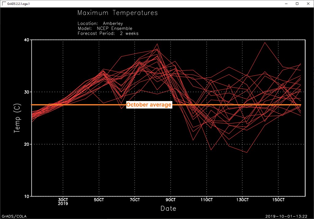 1st and 2nd images above - If you're a glass half full person, you might find this possibility for some enhanced rainfall around the 2nd or 3rd week of October interesting. The probabilities are only a bit above 50/50 as far as above median rainfall goes though. 3rd image - The upcoming significant rise in max temps (Amberley is used for this particular example) showing up well in the members of the NCEP ensemble.
|
4 users thanked Ken for this useful post.
|
|
|
|
Rank: Advanced Member
Groups: Registered
Joined: 21/09/2019(UTC) Posts: 32 Location: Gold coast Thanks: 125 times
Was thanked: 126 time(s) in 31 post(s)
|
Thanks Ken.
Yes. The mainland interior is heating a lot. So its likely there will be some flow on so to speak.
Its is nice to see the chance of some rain increasing for October. It gives some hope for the alleviation of dryness.
Will be watching with interest.
|
3 users thanked juztchillin for this useful post.
|
|
|
|
Rank: Advanced Member
Groups: Registered
Joined: 21/08/2019(UTC) Posts: 35 Location: Toowoomba Thanks: 29 times
Was thanked: 120 time(s) in 33 post(s)
|
Stupid temps for this time of year coming up.39 and 40 for Gatton next week.Couple of 34s for us,Will suck out any moisture left in the ground as we have had the grand total of 3.1mms.
|
4 users thanked Skeetpete for this useful post.
|
|
|
|
Rank: Advanced Member
Groups: Registered
Joined: 21/08/2019(UTC) Posts: 182 Location: Wynnum North Thanks: 656 times
Was thanked: 381 time(s) in 167 post(s)
|
WYNNUM NORTH ( 27.4S 153.2E ) - WEATHER
DATE....2 OCT 2019 TIME....0755
CURRENT TEMPERATURE...20.9C
CURRENT HUMIDITY........68%
CURRENT DEW POINT.......15C
CURRENT WIND DIR/SPEED...SE 17Kph
CURRENT VISIBILITY.....30KM
CURRENT MSL PRESSURE...1029.5Hpa
CURRENT CLOUD..........2/8 Cu, 2/8 Sc
CURRENT WEATHER......Cloud increasing
RAIN SINCE 0900 TUESDAY..1.8mm
SUMMARY LAST 24 HOURS
YESTERDAY'S MAX TEMP. .......23.9C
THIS MORNING'S MIN TEMP......14.1C
PAST 24 HOURS TEMP ANOMALY..-1.90C
THIS MORNING'S GRASS MIN.....14.0C
AVERAGE 24 HOUR DEW POINT......15C
AVERAGE 24 HOUR MSLP........1028.3Hpa
MAX WIND GUST LAST 24 HOURS....E 39Kph at 1209
PAST 24 HR SIGNIFICANT WEATHER..Overnight showers. |
Wyn Nth 2020-Jan165, |
2 users thanked retired weather man for this useful post.
|
|
|
|
Rank: Advanced Member
Groups: Registered
Joined: 13/09/2019(UTC)
Posts: 118
Location: Caboolture (the next Las Vegas!)
Thanks: 215 times
Was thanked: 297 time(s) in 100 post(s)
|
Originally Posted by: Skeetpete Stupid temps for this time of year coming up.39 and 40 for Gatton next week.Couple of 34s for us,Will suck out any moisture left in the ground as we have had the grand total of 3.1mms. Yes, I just say those too. A warm to hot long weekend ahead and then a very hot start to next week. Luckily for me, the ground around here got absolutely saturated. Unfortunately places that missed out will suffer and I assume very high fire dangers again.
|
3 users thanked DelBoy for this useful post.
|
|
|
|
Rank: Advanced Member
Groups: Registered
Joined: 25/08/2019(UTC) Posts: 1,839 Location: Ferny Grove Thanks: 985 times
Was thanked: 856 time(s) in 419 post(s)
|
|
|
2 users thanked Falling_Droplet for this useful post.
|
|
|
|
Rank: Advanced Member
Groups: Registered
Joined: 25/08/2019(UTC) Posts: 1,839 Location: Ferny Grove Thanks: 985 times
Was thanked: 856 time(s) in 419 post(s)
|
A cool and fine day with the temperature rising and falling in partly cloudy skies. Dew point have been near average and after falling during the morning the dew point have been stable. Near average relative humidity and rose and fell a few times today. E to SSE winds became E to NE from later in the afternoon and became calm tonight.
Last 24 hours: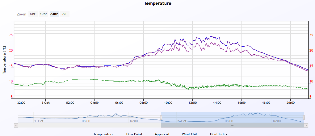 |
|
2 users thanked Falling_Droplet for this useful post.
|
|
|
|
Rank: Advanced Member
Groups: Registered
Joined: 21/08/2019(UTC) Posts: 185 Location: Ocean View Thanks: 359 times
Was thanked: 539 time(s) in 161 post(s)
|
A rather hot long weekend ahead for Brissy by the looks of it with BOM forcasting 32 degrees on Sunday, 35 degrees on Monday and then followed by 36 degrees on Tuesday.
For areas that missed out the high totals of rain from the last trough event are going to get very high fire ratings again. Let's hope the wind stays away this time though.
|
3 users thanked Pabloako for this useful post.
|
|
|
|
Rank: Advanced Member
Groups: Registered
Joined: 21/08/2019(UTC) Posts: 182 Location: Wynnum North Thanks: 656 times
Was thanked: 381 time(s) in 167 post(s)
|
WYNNUM NORTH ( 27.4S 153.2E ) - WEATHER
DATE....3 OCT 2019 TIME....0735
CURRENT TEMPERATURE...16.9C
CURRENT HUMIDITY........72%
CURRENT DEW POINT.......12C
CURRENT WIND DIR/SPEED...SSW 7Kph
CURRENT VISIBILITY.....30KM
CURRENT MSL PRESSURE...1028.4Hpa
CURRENT CLOUD..........1/8 Sc
CURRENT WEATHER......No significant weather
RAIN SINCE 0900 WEDNESDAY..0.0mm
SUMMARY LAST 24 HOURS
YESTERDAY'S MAX TEMP. .......24.6C
THIS MORNING'S MIN TEMP......10.1C
PAST 24 HOURS TEMP ANOMALY..-3.70C
THIS MORNING'S GRASS MIN......9.9C
AVERAGE 24 HOUR DEW POINT......12C
AVERAGE 24 HOUR MSLP........1023.5Hpa
MAX WIND GUST LAST 24 HOURS....E 30Kph at 1025
PAST 24 HR SIGNIFICANT WEATHER..No significant weather. |
Wyn Nth 2020-Jan165, |
4 users thanked retired weather man for this useful post.
|
|
|
|
Rank: Advanced Member
Groups: Registered
Joined: 25/08/2019(UTC) Posts: 1,839 Location: Ferny Grove Thanks: 985 times
Was thanked: 856 time(s) in 419 post(s)
|
Ferny Grove Weather
Date: 3 Oct 2019
Time: 7:40 AM
Min Temp since 9am yesterday: 9.2 C
Max Temp since 9am yesterday: 25.3 C
Min Ground Temp: 7.8 C
Rain since 9am yesterday: Trace
Temperature: 17.1 C
Relative Humidity: 59 %
Dew Point: 9 C
MSL Pressure: 1027.8 hPa
Wind Speed: 3 kph - light air
Wind Direction: S
Present Weather: Clouds generally dissolving or becoming less developed during the preceding hour
Visibility: 20km to 39km - Very Good Visibility
Cloud Cover: 1/8
Ground State: Ground dry
Notes of yesterday weather - 2/10/19: A warm morning and a cool day. The temperature was stable for several hours in the early hours and was variable during the morning and afternoon. Near average dew point was generally stable early before falling during the morning, rose slowly in the afternoon and early evening and fell later in the evening close to average. Moderately low relative humidity early and near average for the rest of the day. The relative humidity was a little variable during the morning and afternoon. Light WSW to SSW winds early becoming, SSW to SSE in the early morning, mostly E SE from mid morning, ESE to ENE in the afternoon tending E to NE later in the afternoon and became calm in the evening.
Today: A cool morning. The dew point have fallen today and became moderately low and have since started to rise and is currently near average. Relative have been moderately low for most of today. Light and variable winds at times becoming light W to SW winds in the last 30 minutes. |
|
1 user thanked Falling_Droplet for this useful post.
|
|
|
|
Rank: Newbie
Groups: Registered
Joined: 25/08/2019(UTC) Posts: 2 Location: Maryborough, QLD Was thanked: 9 time(s) in 2 post(s)
|
Next week looks OK for storms (hopefully!).
|
5 users thanked MegaMatch for this useful post.
|
|
|
|
Rank: Advanced Member
Groups: Registered
Joined: 23/08/2019(UTC) Posts: 155 Location: Narangba Thanks: 280 times
Was thanked: 442 time(s) in 136 post(s)
|
Originally Posted by: MegaMatch Next week looks OK for storms (hopefully!). Hi MegaMatch, I was just looking at that and looking at the heat on Tuesday, followed by a cooler change. BOM only have a small chance of rain, however GFS has a few showers around, impressive LI and good CAPE. Steering winds are from the W to NW. Once again, I hope a knowledgeable person will come and help me before I make a fool of myself  CAPE CAPE Lift Index Lift Index Cloud and other bits Cloud and other bits
|
4 users thanked CantSpellNarangba for this useful post.
|
|
|
|
Weather Forum
»
Australia Weather
»
SEQ and NE NSW
»
SE QLD and NE NSW - Day to Day Weather
Forum Jump
You cannot post new topics in this forum.
You cannot reply to topics in this forum.
You cannot delete your posts in this forum.
You cannot edit your posts in this forum.
You cannot create polls in this forum.
You cannot vote in polls in this forum.
Important Information:
The Weather Forum uses cookies. By continuing to browse this site, you are agreeing to our use of cookies.
More Details
Close
