Weather Forum
»
Australia Weather
»
SEQ and NE NSW
»
SE QLD and NE NSW - Day to Day Weather
Rank: Advanced Member
Groups: Registered
Joined: 25/08/2019(UTC) Posts: 1,839  Location: Ferny Grove Thanks: 985 times
Was thanked: 856 time(s) in 419 post(s)
|
A small cell to the west has developed ahead of the main line. Light to moderate E to NE winds presently. Temperature has stabilised at 30 C and dew point has stabilised close to average. |
|
 3 users thanked Falling_Droplet for this useful post.
|
|
|
|
Rank: Advanced Member
Groups: Registered
Joined: 26/08/2019(UTC) Posts: 32 Location: Bardon Thanks: 96 times
Was thanked: 138 time(s) in 32 post(s)
|
Checked out the Boonah web cam as the line passed through, plenty of rain and wind and a bit of water still lying on the ground there, although it did seem to pass through fairly quickly. Couldn't see any hail lying on the ground.
Friend just north of Beaudesert reports very windy and a lot of thunder around.
|
4 users thanked Greg for this useful post.
|
|
|
|
Rank: Advanced Member
Groups: Registered
Joined: 21/08/2019(UTC) Posts: 35 Location: Toowoomba Thanks: 29 times
Was thanked: 120 time(s) in 33 post(s)
|
Well that was nothing to get excited about.A couple of strong gusts and rain for about 2mins amounting to 1.6mm.
I must say the radar looked good but as usual it splits going around Toowoomba only to improve around Gatton on
the way to Brissie.The line is moving at a good rate of knots.
|
4 users thanked Skeetpete for this useful post.
|
|
|
|
Rank: Advanced Member
Groups: Registered
Joined: 25/08/2019(UTC) Posts: 1,839 Location: Ferny Grove Thanks: 985 times
Was thanked: 856 time(s) in 419 post(s)
|
Brief thunderstorm at 4:40 pm with some heavy rain. Max rain rate of 73.8 mm/hr and wind gust of 46 kph at 4:41 pm. 5.8 mm on the automatic gauge. The temperature fell with the storm and is now 21 C. The dew point have been rising with and following the storm but close to average. E to NE winds before the storm became gusty NNW to WSW winds with the storm and light NE to SE following the storm. Sharp rise in air pressure with the storm.
I am quite pleased with today, though at one point it didn't look good for northern Brisbane. |
|
3 users thanked Falling_Droplet for this useful post.
|
|
|
|
Rank: Advanced Member
Groups: Registered
Joined: 21/09/2019(UTC) Posts: 32 Location: Gold coast Thanks: 125 times
Was thanked: 126 time(s) in 31 post(s)
|
Been a bit busy today to watch radar but here is what l nabbed tonightWell done models .mWondernwhat that front line cloud would of looked like? 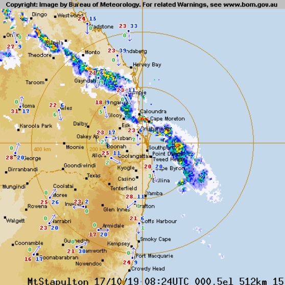
|
5 users thanked juztchillin for this useful post.
|
|
|
|
Rank: Newbie
Groups: Registered
Joined: 23/08/2019(UTC) Posts: 9 Location: Burrum Heads Thanks: 20 times
Was thanked: 26 time(s) in 8 post(s)
|
Horrible gusting wind all arvo with gum trees dropping limbs all over the paddocks. The wind has dropped off now and if that band can just hold together and reach the coast it will be most welcome.
|
4 users thanked Pharbelle for this useful post.
|
|
|
|
Rank: Advanced Member
Groups: Registered
Joined: 2/09/2019(UTC) Posts: 105 Location: Brisbane Thanks: 145 times
Was thanked: 561 time(s) in 103 post(s)
|
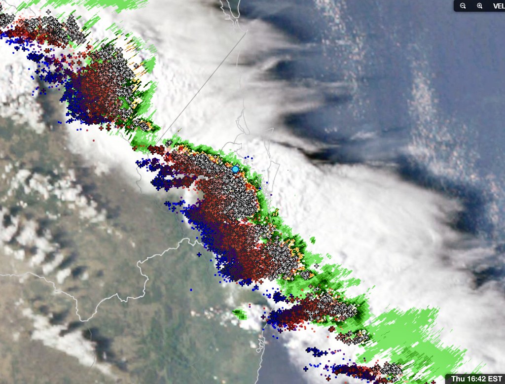   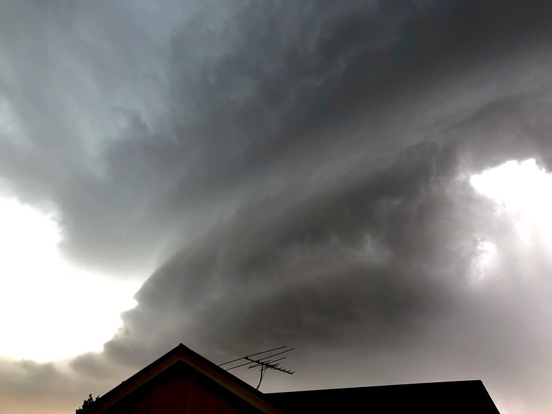   Great photos and reports everyone. 1st image above - Nice satpic/radar/lightning image via WZ. 2nd and 3rd images - Some stills from a couple of videos off my phone I took in Moorooka. 4th image - My view from Moorooka just before we got hit. 5th image - The huge shelf cloud bearing down on Mt Coottha as shared to fb by Cindy Parker. 6th image - Impressive photo taken by Karl Hircock at Wellington Point and shared to fb.
|
6 users thanked Ken for this useful post.
|
|
|
|
Rank: Advanced Member
Groups: Registered
Joined: 25/08/2019(UTC) Posts: 1,839 Location: Ferny Grove Thanks: 985 times
Was thanked: 856 time(s) in 419 post(s)
|
|
|
3 users thanked Falling_Droplet for this useful post.
|
|
|
|
Rank: Advanced Member
Groups: Registered
Joined: 21/08/2019(UTC) Posts: 182 Location: Wynnum North Thanks: 656 times
Was thanked: 381 time(s) in 167 post(s)
|
WYNNUM NORTH ( 27.4S 153.2E ) - WEATHER
DATE....18 OCT 2019 TIME....0720
CURRENT TEMPERATURE...22.1C
CURRENT HUMIDITY........83%
CURRENT DEW POINT.......19C
CURRENT WIND DIR/SPEED...SE 19Kph
CURRENT VISIBILITY.....17KM
CURRENT MSL PRESSURE...1016.6Hpa
CURRENT CLOUD..........1/8 St, 2/8 Ac, 1/8 Cc
CURRENT WEATHER......Haze
RAIN SINCE 0900 THURSDAY...2.2mm
SUMMARY LAST 24 HOURS
YESTERDAY'S MAX TEMP. .......27.6C
THIS MORNING'S MIN TEMP......16.9C
PAST 24 HOURS TEMP ANOMALY..+1.35C
THIS MORNING'S GRASS MIN.....16.8C
AVERAGE 24 HOUR DEW POINT......20C
AVERAGE 24 HOUR MSLP........1012.1Hpa
MAX WIND GUST LAST 24 HOURS....NE 55Kph at 1440
PAST 24 HR SIGNIFICANT WEATHER...Smoke haze. Brief thunderstorm, weakened by the seabreeze, late Thursday afternoon. |
Wyn Nth 2020-Jan165, |
2 users thanked retired weather man for this useful post.
|
|
|
|
Rank: Advanced Member
Groups: Registered
Joined: 25/08/2019(UTC) Posts: 1,839 Location: Ferny Grove Thanks: 985 times
Was thanked: 856 time(s) in 419 post(s)
|
Ferny Grove Weather
Date: 18 Oct 2019
Time: 7:45 AM
Min Temp since 9am yesterday: 16.6 C
Max Temp since 9am yesterday: 32.8 C
Min Ground Temp: 15.8 C
Rain since 9am yesterday: 6 mm
Temperature: 23 C
Relative Humidity: 70 %
Dew Point: 17.2 C
MSL Pressure: 1016.9 hPa
Wind Speed: 9 kph - light breeze
Wind Direction: ESE
Present Weather: Clouds generally dissolving or becoming less developed during the preceding hour
Visibility: 20km to 39km - Very Good Visibility
Cloud Cover: 3/8
Ground State: Ground moist
Thunder yesterday: Yes
Notes of yesterday weather - 17/10/19: Partly cloudy with cu and ci clouds in the morning with increasing cu, sc, as, ci, cs and cb clouds in the afternoon and cloudy at times. A moderate and gusty brief thunderstorm at 4:40 pm with some heavy falls. Smoke haze. The dew point was stable early in the day before rising during the morning and stabilising from the late morning close to average after falling slightly. In the early afternoon the dew point rose before falling for the rest of the day while remaining close to average. For 1 hour with and following the thunderstorm the dew point rose. A warm morning and a hot day. The temperature fell quickly and the relative humidity rose quickly with the thunderstorm. Light winds at times early in the day was mostly NE to NW with some W to SW in the early hours, E to NNE from mid morning, light to moderate E to NE in the afternoon, gusty NNW to W winds with the storm and light NE to SE winds at times following the thunderstorm. A sharp rise in air pressure with the thunderstorm.
Today: A warm morning with a small rise in the temperature at 3am. Dew point have been near average which have been falling and then rising after sunrise. A temporary fall in relative humidity at 3 am. Light W to SW winds at times early today becoming light S to SE in the last hour.
|
|
1 user thanked Falling_Droplet for this useful post.
|
|
|
|
Rank: Advanced Member
Groups: Registered
Joined: 2/09/2019(UTC) Posts: 105 Location: Brisbane Thanks: 145 times
Was thanked: 561 time(s) in 103 post(s)
|
 I think a surprisingly decent amount of rainfall could occur on Saturday for a number of locations in northern SE QLD/some sections of the WBB in particular. The SE to E wind change that stabilised the air over SE QLD after Thursday stalls then gets pushed back down the coast by northerly winds while weakening. This allows a more humid and unstable northerly flow to temporarily return to the region and combined with the nearby trough, causes showers, some thunderstorms, and possibly some rain areas to develop in northern and northwestern SE QLD (and the northeastern Downs, southern and western Wide Bay and Burnett, etc) before some of this activity spreads a bit further south during the day. Most of this activity then progressively clears out of SE QLD on Saturday night. Some lower lying areas which experience rainfall may also get rapid dense fog formation at night after the rainfall clears. It doesn't look like the far southern Downs and Granite Belt are likely to get a lot out of this, if anything at all, while areas like the Sunshine Coast hinterlands are more favourable. I've summarised what I think are some of the more notable differences from what we had on Thursday: 1). Activity likely to develop earlier than usual in northwestern and northern parts of SE QLD (perhaps as early as morning in some places), partly due to more moisture and earlier onset of instability. 2). Could be some decent rainfall amounts in a number of locations in northwestern and northern parts due to more moisture (naturally, some places won't do well and some will, depending on where the deeper convection is). 3). Although the main focus for the thunder and better rainfall is likely to be in those northwestern and northern parts, some other sections of SE QLD are also in with a shot for some shower or thunderstorm activity, particularly if the strong westerly steering winds aloft advect any inland storms towards the coast (but less locations are likely to be affected compared to further north).... or if activity spreads further south than expected. 4). More morning cloud cover in northern, northwestern, & central parts - this, together with earlier initiation makes the chance of severe storms in SE QLD less certain than Thursday but the possibility can't be ruled out yet for some locations due to good shear.
|
4 users thanked Ken for this useful post.
|
|
|
|
Rank: Advanced Member
Groups: Registered
Joined: 24/08/2019(UTC) Posts: 292 Location: Country Victorian Thanks: 580 times
Was thanked: 503 time(s) in 194 post(s)
|
WOW KEN a fabulous post there. Great report and thanks for the photos as well. 
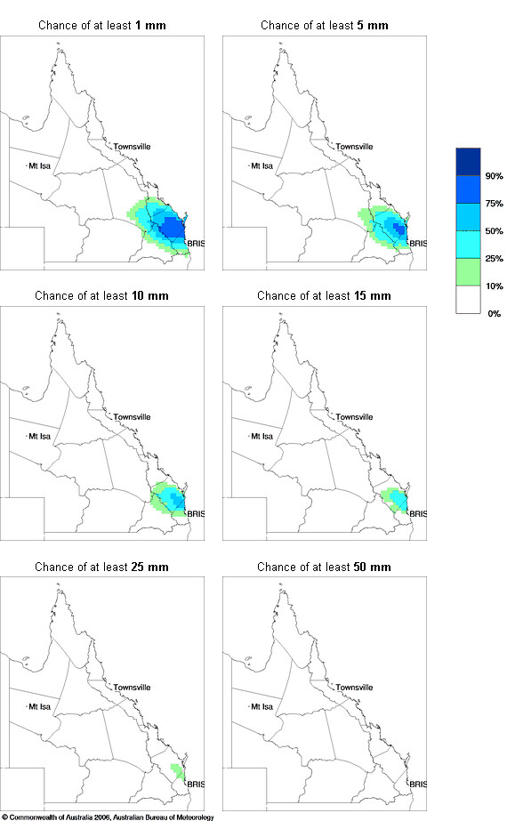
Nice to see an event to keep the storm enthusiasts happy................. ACCESS r seeing this precip' signal over sunshine coast and hinterlands as well.
ACC r has weak precip' signal as early as 5am Saturday morning and strengthening during the day.
ACC giving the best, strongest activity between 11am and 5pm Saturday
Gradient winds showing a closed low west of the hinterlands at 5am
This structure then morphs into a well defined trough line during the day. SW on west flank and NE on east flank
Of interest is some quite strong gradient Southerly winds coming in behind the trough around 5pm Saturday for inland areas of Qld and extending right up to the gulf of Carpentaria. source http://www.bom.gov.au/au...chartSubmit=Refresh+ViewEdited by user Friday, 18 October 2019 6:33:28 PM(UTC)
| Reason: Not specified
|
1 user thanked crikey for this useful post.
|
|
|
|
Rank: Advanced Member
Groups: Registered
Joined: 25/08/2019(UTC) Posts: 1,839 Location: Ferny Grove Thanks: 985 times
Was thanked: 856 time(s) in 419 post(s)
|
Much cooler today with close to average but variable temperature during the day. The dew point have been stable and near average after falling earlier in the morning. Near average relative humidity today. Winds SSE to E and some E to ENE in the afternoon. Winds became mostly calm from 8pm. Last 24 hours:  Edited by user Friday, 18 October 2019 10:37:54 PM(UTC)
| Reason: Not specified |
|
|
|
|
|
|
Rank: Advanced Member
Groups: Registered
Joined: 21/08/2019(UTC) Posts: 182 Location: Wynnum North Thanks: 656 times
Was thanked: 381 time(s) in 167 post(s)
|
WYNNUM NORTH ( 27.4S 153.2E ) - WEATHER
DATE....19 OCT 2019 TIME....0745
CURRENT TEMPERATURE...21.1C
CURRENT HUMIDITY........83%
CURRENT DEW POINT.......18C
CURRENT WIND DIR/SPEED...S 3Kph
CURRENT VISIBILITY.....18KM
CURRENT MSL PRESSURE...1018.4Hpa
CURRENT CLOUD..........8/8 CuSc
CURRENT WEATHER......Haze
RAIN SINCE 0900 FRIDAY...0.0mm
SUMMARY LAST 24 HOURS
YESTERDAY'S MAX TEMP. .......27.1C
THIS MORNING'S MIN TEMP......17.1C
PAST 24 HOURS TEMP ANOMALY..+1.20C
THIS MORNING'S GRASS MIN.....16.9C
AVERAGE 24 HOUR DEW POINT......18C
AVERAGE 24 HOUR MSLP........1016.71Hpa
MAX WIND GUST LAST 24 HOURS....SE 34Kph at 0955
PAST 24 HR SIGNIFICANT WEATHER...Haze. |
Wyn Nth 2020-Jan165, |
|
|
|
|
|
Rank: Advanced Member
Groups: Registered
Joined: 26/08/2019(UTC) Posts: 32 Location: Bardon Thanks: 96 times
Was thanked: 138 time(s) in 32 post(s)
|
Radar is alive some nice showers around the place and moving to the east at the moment. A nice shower of rain here at the moment, heavier than the storms earlier in the week.
Greg
|
1 user thanked Greg for this useful post.
|
|
|
|
Rank: Advanced Member
Groups: Registered
Joined: 25/08/2019(UTC) Posts: 1,839 Location: Ferny Grove Thanks: 985 times
Was thanked: 856 time(s) in 419 post(s)
|
Ferny Grove Weather
Date: 19 Oct 2019
Time: 9:30 AM
Min Temp since 9am yesterday: 17.3 C
Max Temp since 9am yesterday: 28.3 C
Min Ground Temp: 16.3 C
Rain since 9am yesterday: 0 mm
Temperature: 22.6 C
Relative Humidity: 67 %
Dew Point: 16.1 C
MSL Pressure: 1018.2 hPa
Wind Speed: light air
Wind Direction: WSW
Present Weather: State of sky generally unchanged during preceding hour
Visibility: 20km to 39km - Very Good Visibility
Cloud Cover: 8/8
Ground State: Ground moist
Notes of yesterday weather - 18/10/19: Partly cloudy with ac and sc in the morning, cu clouds later in the morning, clearing in the afternoon. A warm morning. A small rise in temperature at 3 am and variable temperature during the morning and afternoon. Dew point was stable before falling in the early hours and then rising in the early morning close to average. For the rest of the morning the dew point fell before stablising in the afternoon and evening. Light NW to SW winds at times early before S to SE winds in the early morning and a E to SE wind change during the morning. Light ESE to ENE winds in the afternoon and afternoon.
Today: Light shower at 9:35 am and further showers approaching to the west. A warm morning. The temperature stopped rising from 8:30am and have since started to fall. The dew point have been near average and rising during this morning. Mostly S to SW winds since the early morning.
|
|
1 user thanked Falling_Droplet for this useful post.
|
|
|
|
Rank: Advanced Member
Groups: Registered
Joined: 2/09/2019(UTC) Posts: 105 Location: Brisbane Thanks: 145 times
Was thanked: 561 time(s) in 103 post(s)
|
 The significant increase in the showers and storms this morning have been playing out as the models have predicted. Got good downpours and thunder here.
|
2 users thanked Ken for this useful post.
|
Greg on 19/10/2019(UTC), crikey on 20/10/2019(UTC)
|
|
|
Rank: Advanced Member
Groups: Registered
Joined: 26/08/2019(UTC) Posts: 32 Location: Bardon Thanks: 96 times
Was thanked: 138 time(s) in 32 post(s)
|
Yes Ken your predictions were spot on. Some loud thunder here and some very nice rain. Feel sorry for one of the local state schools near here, no rain for ages and then a downpour on the day of the school fair.
|
2 users thanked Greg for this useful post.
|
Ken on 19/10/2019(UTC), crikey on 20/10/2019(UTC)
|
|
|
Rank: Advanced Member
Groups: Registered
Joined: 25/08/2019(UTC) Posts: 1,839 Location: Ferny Grove Thanks: 985 times
Was thanked: 856 time(s) in 419 post(s)
|
Light showers followed by a moderate thunderstorm at 11:40 am which has now cleared. Some heavy rain with the storm with a maximum rain rate of 140.4 mm/hr at 11:49 am. 6.8 mm of rainfall since 9am. It cooled 2 C to 20 C with the thunderstorm and now the sun has come out with the temperature starting to rise again. Dew point rose slowly before the storm and more quickly with the thunderstorm and is currently 19 C and also the relative humidity rose with the storm. Light W to SSW winds became ESE to S following the storm.
Further cells are developing further inland. The bureau updated the forecast a few hours ago to a very high chance of rainfall and meteye shows the potential for good falls this afternoon. |
|
1 user thanked Falling_Droplet for this useful post.
|
|
|
|
Rank: Advanced Member
Groups: Registered
Joined: 25/08/2019(UTC) Posts: 1,839 Location: Ferny Grove Thanks: 985 times
Was thanked: 856 time(s) in 419 post(s)
|
Fine since the thunderstorm except for a light shower at 2pm. Cloud have been thickening with storms to the northwest. The temperature have been rising in the last few hours and reached 25 C and has started to drop. Dew point continued to rise after the earlier thunderstorm and have reached 20 C (moderately high). Relative humidity dropped back slightly but has remained high at around 75%. Wind have been quite light N to NE. |
|
2 users thanked Falling_Droplet for this useful post.
|
|
|
|
Weather Forum
»
Australia Weather
»
SEQ and NE NSW
»
SE QLD and NE NSW - Day to Day Weather
Forum Jump
You cannot post new topics in this forum.
You cannot reply to topics in this forum.
You cannot delete your posts in this forum.
You cannot edit your posts in this forum.
You cannot create polls in this forum.
You cannot vote in polls in this forum.
Important Information:
The Weather Forum uses cookies. By continuing to browse this site, you are agreeing to our use of cookies.
More Details
Close
