Weather Forum
»
Australia Weather
»
SEQ and NE NSW
»
SE QLD and NE NSW - Day to Day Weather
Rank: Advanced Member
Groups: Registered
Joined: 26/08/2019(UTC) Posts: 32  Location: Bardon Thanks: 96 times
Was thanked: 138 time(s) in 32 post(s)
|
Somerset Regional Council covers part of the Brisbane River Valley and maintain a series of live flood cameras at some road crossings in their area. https://eservices.somers...ult.asp?cam=mountstanleyAfter 102 mm of rain last night at Gregors Creek we are finally seeing some inflow into Wivenhoe. This is the web cam image of the Brisbane River upstream from Linville at 744 am this morning. You can just see the road at the bottom of the picture.  From the Somerset Regional Council.
|
 2 users thanked Greg for this useful post.
|
|
|
|
Rank: Advanced Member
Groups: Registered, Administrators Joined: 21/08/2019(UTC) Posts: 941 Location: Brisbane Northside Thanks: 1198 times
Was thanked: 1136 time(s) in 674 post(s)
|
So far at Bracken Ridge we have received 339 mm of rain since the start of this system on Friday. Showers and thunderstorm have persisted throughout this afternoon with storm warnings in place. BoM have issued flood watch no.9 for SEQ. Flood Watch for South East Queensland catchments between Bundaberg and the NSW border Issued at 12:38 pm EST on Tuesday 11 February 2020 Flood Watch Number: 9 There is a continued risk of heavy rainfall and river level rises across the Flood Watch through to Friday. Showers and thunderstorms are forecast for the Flood Watch area with localised heavy falls possible each day, though rainfall activity should start to ease over the course of Friday. Most catchments across the Flood Watch area have received significant rainfall during the past week and are likely to respond quickly to further heavy rainfall. Minor flooding is likely, with higher levels possible in the areas of heaviest rainfall. Localised flooding and disruption to transport routes are likely particularly in the area of the heaviest rainfall. Catchments likely to be affected include: Burnett River Burrum and Cherwell Rivers Mary River Noosa River Sunshine Coast Rivers and Creeks Pine and Caboolture Rivers Upper Brisbane River(A flood warning is current for the upper Brisbane River at the time of issue) Lower Brisbane River Logan and Albert Rivers Gold Coast Rivers and Creeks Edited by user Tuesday, 11 February 2020 3:55:20 PM(UTC)
| Reason: Added rain totals |
Colin Maitland. |
1 user thanked Colmait for this useful post.
|
|
|
|
Rank: Advanced Member
Groups: Registered
Joined: 25/08/2019(UTC) Posts: 1,839 Location: Ferny Grove Thanks: 985 times
Was thanked: 856 time(s) in 419 post(s)
|
A mild thunderstorm this afternoon from 3:40 pm, with a brief period of heavy rain (2.8 mm in 2 minutes) at 3:46pm and followed by light rain. A drizzle in the late morning and a light shower earlier tonight. 6.5 mm since 9am.
A near average maximum temperature was r reached at 2:50pm before falling quite quickly by 5 C in an hour to 25 C. Following this through to tonight the temperature have been near stable though it did rise a little before starting to fall a little in the late afternoon. Dew point rose during the morning and in the afternoon moderately high to a high of 25 C at the same time as the maximum temperature. The dew point fell a little following, though did temporarily rise later in the afternoon becoming stable tonight. Relative humidity is currently 89% after being moderately high today and have become high with and following the storm.
Rainfall MTD is 267.9 mm (106.1 mm above average). YTD is 451.2 mm (144.4 mm above average) and event total is 256 mm. |
|
1 user thanked Falling_Droplet for this useful post.
|
|
|
|
Rank: Advanced Member
Groups: Registered
Joined: 25/08/2019(UTC) Posts: 1,839 Location: Ferny Grove Thanks: 985 times
Was thanked: 856 time(s) in 419 post(s)
|
|
|
1 user thanked Falling_Droplet for this useful post.
|
|
|
|
Rank: Advanced Member
Groups: Registered
Joined: 25/08/2019(UTC) Posts: 1,839 Location: Ferny Grove Thanks: 985 times
Was thanked: 856 time(s) in 419 post(s)
|
Ferny Grove Weather
Date: 12 Feb 2020
Time: 7:30 AM
Min Temp since 9am yesterday: 21.3 C
Max Temp since 9am yesterday: 30.4 C
Min Ground Temp: 20.8 C
Rain since 9am yesterday: 12.4 mm
Temperature: 23.3 C
Relative Humidity: 93 %
Dew Point: 22.1 C
MSL Pressure: 1007.1 hPa
Wind Speed: Calm
Wind Direction: Calm
Present Weather: Precipitation observed within sight of the station reaching the ground but more than 5km away
Visibility: 4km to 9km - Moderate Visibility
Cloud Cover: 8/8
Ground State:
Thunder yesterday: Yes
Notes of yesterday weather - 11/2/20: Partly cloudy with cu and sc clouds becoming cloudy in the afternoon some cb clouds. A mild thunderstorm at 3:40pm with brief heavy falls followed by light rain until 4pm. Later in the evening at 10:30 pm was a mild thunderstorm with a very brief period of heavy rain. Stable temperature in the early hours of the day. The maximum temperature was reached at 3pm before falling quite quickly under increasing cloud and fell 5 C in an hour. The temperature was then stable except for a temporary rise in the late afternoon before starting to fall with and following the late evening storm. The dew point was stable and near average early in the day before rising during the morning and in the afternoon becoming moderately high. The dew point reached its maximum at the same time as the maximum for the temperature before falling ahead and with the afternoon storm. Following this the dew point have been generally stable but moderately high before falling in the late evening. Stable and high relative humidity early in the day, was moderately high during the day, became high with and following the afternoon storm and was stable in the evening. Mostly calm winds early in the day, SE to SW winds during the morning, NE to NW winds in the early afternoon, N through to ESE from 2pm, N to NW in the late afternoon before light E to NE with evening storm, became calm in the evening and N to NW in the late evening.
Today: Mostly calm winds today. The dew point fell in the early hours of today before starting to rise this morning. Relative humidity have been stable and high.
Event total is 261.9 mm.
|
|
1 user thanked Falling_Droplet for this useful post.
|
|
|
|
Rank: Advanced Member
Groups: Registered, Administrators Joined: 21/08/2019(UTC) Posts: 941 Location: Brisbane Northside Thanks: 1198 times
Was thanked: 1136 time(s) in 674 post(s)
|
More rain today with heavy falls this morning, meanwhile the current system is moving south I would expect that this warning will extend further south STW from BoM TOP PRIORITY FOR IMMEDIATE BROADCAST Severe Thunderstorm Warning - Southeast Queensland for HEAVY RAINFALL For people in parts of Gympie, Sunshine Coast, Noosa and Moreton Bay Council Areas. Issued at 11:41 am Wednesday, 12 February 2020. Weather Situation: Severe thunderstorms are likely to produce heavy rainfall that may lead to flash flooding in the warning area over the next several hours. Locations which may be affected include Gympie, the area southeast of Gympie and Pomona. 50 mm rainfall was recorded at Baroon Boat Camp in the hour to 11:30 am AEST.  |
Colin Maitland. |
1 user thanked Colmait for this useful post.
|
|
|
|
Rank: Advanced Member
Groups: Registered, Administrators Joined: 21/08/2019(UTC) Posts: 941 Location: Brisbane Northside Thanks: 1198 times
Was thanked: 1136 time(s) in 674 post(s)
|
|
Colin Maitland. |
1 user thanked Colmait for this useful post.
|
|
|
|
Rank: Advanced Member
Groups: Registered
Joined: 25/08/2019(UTC) Posts: 1,839 Location: Ferny Grove Thanks: 985 times
Was thanked: 856 time(s) in 419 post(s)
|
12.9 mm to 9am. 16 mm since 9am from some light showers during the mid morning before increasing in frequency during the afternoon until earlier tonight. Mostly light falls with brief moderate to heavy falls at 5:40 pm.
A cool day with a maximum temperature of 27 C and was a little variable from mid morning to mid afternoon. The dew point was a little variable during the morning while rising back to moderately high to a maximum of 24 C in the late morning. After this the dew point have been a little variable and stable. Tonight the dew point fell a little before becoming stable close to average. Relative humidity have remained high today falling to a low of 80% during the middle of the day and is currently 92%. Winds have been SSE to ESE, E to SE in the late morning, NNE to ENE from the early afternoon and E to SE winds later in the afternoon with some calm winds. Tonight winds have been calm at times with some E to SE winds. |
|
1 user thanked Falling_Droplet for this useful post.
|
|
|
|
Rank: Advanced Member
Groups: Registered
Joined: 25/08/2019(UTC) Posts: 1,839 Location: Ferny Grove Thanks: 985 times
Was thanked: 856 time(s) in 419 post(s)
|
|
|
1 user thanked Falling_Droplet for this useful post.
|
|
|
|
Rank: Advanced Member
Groups: Registered, Administrators Joined: 21/08/2019(UTC) Posts: 941 Location: Brisbane Northside Thanks: 1198 times
Was thanked: 1136 time(s) in 674 post(s)
|
More rain, it is getting a bit ridiculous on some of the coastal areas now. We are close to the 400 mm mark in just 5 days. Another flood alert and storm warning issued 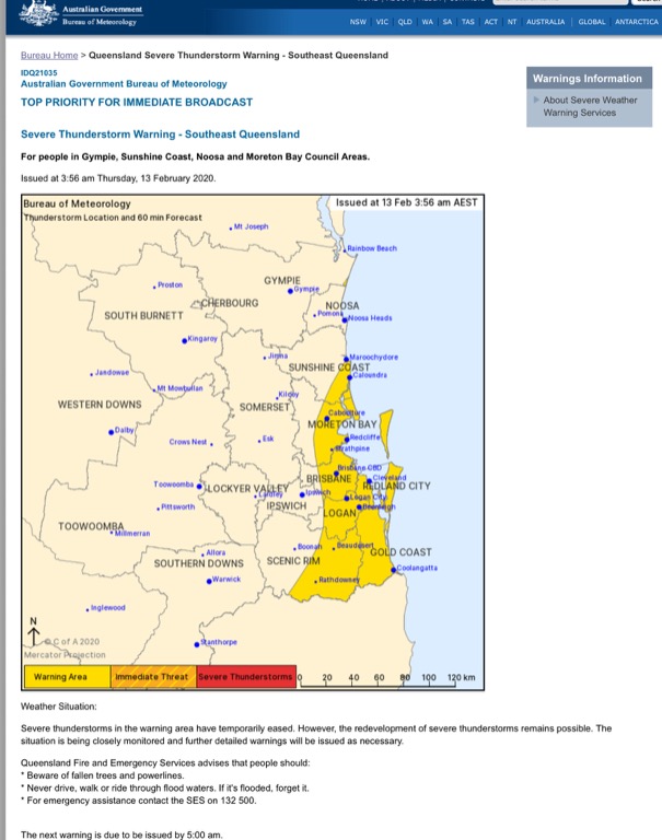  Edited by user Thursday, 13 February 2020 4:26:29 AM(UTC)
| Reason: Not specified |
Colin Maitland. |
|
|
|
|
|
Rank: Advanced Member
Groups: Registered, Administrators Joined: 21/08/2019(UTC) Posts: 941 Location: Brisbane Northside Thanks: 1198 times
Was thanked: 1136 time(s) in 674 post(s)
|
Just tallied up our rainfall and at Bracken Ridge we mow have had 454 mm since Friday. It is still just streaming in of Moreton Bay as at 07:07am Thursday. There has been flash flooding reported throughout different locations in Brisbane, Bribie Island, Moreton Shire and the Sunshine Coast. Radar image and rainfall total charts below. 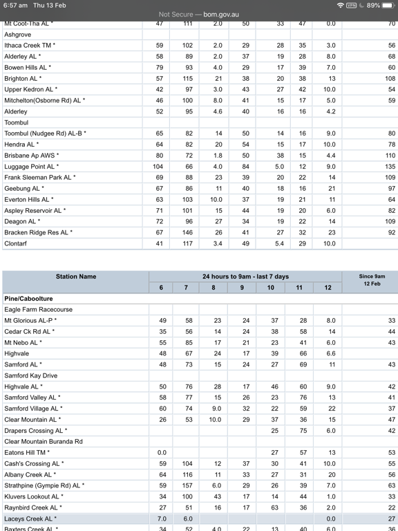 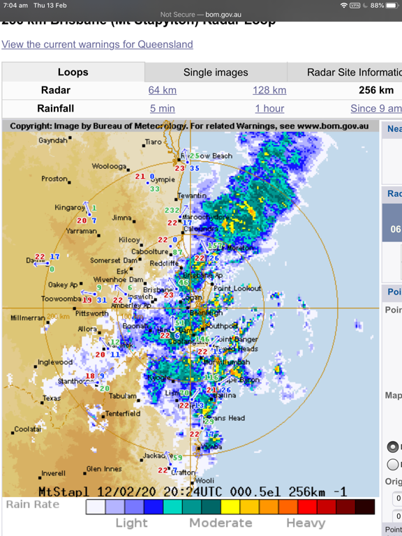 |
Colin Maitland. |
|
|
|
|
|
Rank: Advanced Member
Groups: Registered
Joined: 25/08/2019(UTC) Posts: 1,839 Location: Ferny Grove Thanks: 985 times
Was thanked: 856 time(s) in 419 post(s)
|
Ferny Grove Weather
Date: 13 Feb 2020
Time: 7:50 AM
Min Temp since 9am yesterday: 21.4 C
Max Temp since 9am yesterday: 26.9 C
Min Ground Temp: 21 C
Rain since 9am yesterday: 60.3 mm
Temperature: 22.6 C
Relative Humidity: 93 %
Dew Point: 21.4 C
MSL Pressure: 1005.4 hPa
Wind Speed: light air
Wind Direction: SW
Present Weather: Continuous, slight drizzle
Visibility: 10km to 19km - Good Visibility
Cloud Cover: 8/8
Ground State: Ground Moist
Thunder yesterday: Yes
Notes of yesterday weather - 12/2/20: Cloudy with cu, sc and ns clouds. Light showers during the mid morning and during the afternoon becoming more frequent later in the afternoon with light falls and brief heavy falls at 5:40pm with some thunder. A shower with moderate falls in the mid evening with brief heavy falls and then light showers. Light rain in the late evening. A cool day with the temperature variable from the mid morning to mid afternoon. The dew point fell in the early hours of the day returning to near average before rising during the morning to moderately high. In the afternoon the dew point was a little variable and fell slowly before falling during the evening returning to near average later in the evening. Relative humidity was stable and high early in the day, remained high during the day and became stable in the evening. Calm winds early in the day, SSE to ESE light winds during the morning, E to SE from the late morning, NNE to ENE from the early afternoon and E to SE winds later in the afternoon with some calm winds. In the evening winds were calm at times with winds mostly E to SE in the early evening and S to SE later in the evening.
Today: Mostly calm winds in the early hours of today before S to SSE winds in the early morning of today before backing during this morning and is currently W to SW. The temperature and dew point have been falling quite slowly today before starting to rise in the last hour. Dew point have remained close to average. Relative humidity have been very stable and high. Light rain from the start of the day, temporarily a little heavier but remaining light for 5 minutes at 3:30 am and drizzle and very light rain from 5:30 am.
Event total is 322.2 mm, MTD is 334.1 mm and YTD is 517.4 mm.
|
|
1 user thanked Falling_Droplet for this useful post.
|
|
|
|
Rank: Advanced Member
Groups: Registered
Joined: 25/08/2019(UTC) Posts: 1,839 Location: Ferny Grove Thanks: 985 times
Was thanked: 856 time(s) in 419 post(s)
|
Drizzle and very light rain temporarily cleared during the morning before returning from the mid morning to the early afternoon. From 6:50 pm light rain have returned with 0.5 mm since 9am before the light rain tonight and is currently 8.5 mm since 9am.
A cold day with a maximum temperature of 25 C and with the temperature a little variable from the mid morning to mid afternoon. The dew point continued to rise during the morning and became moderately high in the late morning before falling during the afternoon and tonight and returned to near average in the late afternoon. The relative humidity fell a little during the day to a low of 85% whilst remaining high, before rising since the late afternoon and is currently 91%. SW light winds at 8am, S to SW from the late morning, S to SSW in the early afternoon, SSW to SW from mid morning, SSW to SW winds tonight, with some S to SSW winds as the light rain started tonight. |
|
1 user thanked Falling_Droplet for this useful post.
|
|
|
|
Rank: Advanced Member
Groups: Registered
Joined: 25/08/2019(UTC) Posts: 1,839 Location: Ferny Grove Thanks: 985 times
Was thanked: 856 time(s) in 419 post(s)
|
|
|
2 users thanked Falling_Droplet for this useful post.
|
|
|
|
Rank: Advanced Member
Groups: Registered
Joined: 25/08/2019(UTC) Posts: 1,839 Location: Ferny Grove Thanks: 985 times
Was thanked: 856 time(s) in 419 post(s)
|
Ferny Grove Weather
Date: 14 Feb 2020
Time: 7:25 AM
Min Temp since 9am yesterday: 20.9 C
Max Temp since 9am yesterday: 25.3 C
Min Ground Temp: 20.6 C
Rain since 9am yesterday: 31 mm
Temperature: 22.3 C
Relative Humidity: 93 %
Dew Point: 21.1 C
MSL Pressure: 1005.9 hPa
Wind Speed: 1 kph - light air
Wind Direction: WSW
Present Weather: Clouds generally dissolving or becoming less developed during the preceding hour
Visibility: 20km to 39km - Very Good Visibility
Cloud Cover: 6/8
Ground State: Ground Moist
Notes of yesterday weather - 13/2/20: Cloudy with cu, sc and ns clouds. A cold day with the temperature a little variable from the mid morning to mid afternoon. Light rain in the early hours of the day, temporarily heavier while remaining light for 5 minutes at 3:30 am before drizzle and very light rain from 5:30 am. During the morning the rainfall cleared before returning from the mid morning through to the early afternoon. In the evening was light rain with some moderate falls tapering off to very light rain in the late evening. The dew point fell slowly in the early hours of the day, rose during the morning, became moderately high in the late afternoon and then fell during the afternoon. The dew point returned to near average in the late afternoon. During the evening the dew point remained close to average while slowly falling. The relative humidity was stable and high from early in the day, before falling a little during the day while remaining high before rising from the late afternoon. Mostly calm winds in the early hours of the day, S to SSE winds in the early morning, backed during the morning to W to SW winds in the morning. From the late morning winds were S to SW, S to SSW in the early afternoon and SSW to SW from the mid afternoon. In the evening was SW to SSW winds with some S to SSW at the start of the evening light rain.
Today: No rainfall so far today. Mostly calm winds today. The dew point slowly fell early today before stating to rise this morning close to average. Relative humidity have remained high and have been stable so far today.
Event total is 353.2 mm, MTD is 365.1 mm and YTD is 548.4 mm.
|
|
1 user thanked Falling_Droplet for this useful post.
|
|
|
|
Rank: Advanced Member
Groups: Registered
Joined: 25/08/2019(UTC) Posts: 1,839 Location: Ferny Grove Thanks: 985 times
Was thanked: 856 time(s) in 419 post(s)
|
|
|
1 user thanked Falling_Droplet for this useful post.
|
|
|
|
Rank: Advanced Member
Groups: Registered
Joined: 25/08/2019(UTC) Posts: 1,839 Location: Ferny Grove Thanks: 985 times
Was thanked: 856 time(s) in 419 post(s)
|
Daily rainfall totals (24 hours to 9am) for the event (total of 364.9 mm) at Ferny Grove:
4th Feb: 9.6 mm
5th Feb: 1.6 mm
6th Feb: 45.6 mm
7th Feb: 93.9 mm
8th Feb: 3.5 mm
9th Feb: 37.5 mm
10th Feb: 33.5 mm
11th Feb: 35.5 mm
12th Feb: 12.9 mm
13th Feb: 60.3 mm
14th Feb: 31 mm
Long period rainfall totals for 6, 9 and 12 months have returned to near average values, whilst totals for 18, 24, 36 and 48 months still remain below average.
Of the last 30 years at Ferny Grove this is the third highest February rainfall total (365.6 mm, 125% above the long term average and 203.8 mm above average) so far and the highest since 464.8 mm in 1995. 2015 was 328.5mm and 2013 was 231.2mm. Looking at only the total rainfall for the first 15 days of past Februaries results in 2020 being the highest on record. For all months of the year this is the highest since 375.4 mm in March 2017.
The daily rainfall totals were not significantly high but the sustained culmination of rainfall over a long period was quite exceptional for my location. The highest daily rainfall total of 90.9 mm was the 9th highest February daily rainfall total and the highest since 143.4 mm on the 24st in 2018. For any month it was also the highest since 143.4 mm on 24 February 2018.
For the number of days of consecutive days of rainfall this was 11 days which compared to previous February wet spells equalled 284.4 mm in 11 days between 14 February 2015 and 25 February 2015. That was the second highest on record, whereas the longest February wet spell is 14 days between 31 January and 7 February 2003 (99.5 mm).
When compared with previous wet spells across all months there were 24 other previous periods of greater than 11 days with the highest being 62 days between 28 March and 9 April 2011 (70.5 mm).
But as for wet spell total this event was significant compared to previous wet spells rainfall totals and was the highest for February (previously 284.4 mm between 14 February 2015 and 25 February 2015). For any month this was the highest since 459 mm between the 23 January and 29 January 2013.
The year to date total of 548.9 mm (242.1 mm above average and 78.9 % above average) when compared with previous January to February totals is the highest since 711.9 mm in 2013.
|
|
1 user thanked Falling_Droplet for this useful post.
|
|
|
|
Rank: Advanced Member
Groups: Registered
Joined: 25/08/2019(UTC) Posts: 1,839 Location: Ferny Grove Thanks: 985 times
Was thanked: 856 time(s) in 419 post(s)
|
Ferny Grove Weather Date: 15 Feb 2020 Time: 7:50 AM Min Temp since 9am yesterday: 21.4 C Max Temp since 9am yesterday: 30.6 C Min Ground Temp: 20.9 C Rain since 9am yesterday: 0 mm Temperature: 24.8 C Relative Humidity: 85 % Dew Point: 22.1 C MSL Pressure: 1007.3 hPa Wind Speed: 1 kph - light air Wind Direction: NE Present Weather: No cloud development observed Visibility: 20km to 39km - Very Good Visibility Cloud Cover: 0/8 Ground State: Ground moist Notes of yesterday weather - 14/2/20: Clear early and partly cloudy from the morning with cu and sc clouds. The temperature fell slowly early in the day and was variable during the late morning and during the afternoon. The dew point slowly fell early in the day before rising during the morning, became moderately high from the middle of the morning, before becoming stable later in the morning. The dew point then fell sharply at 10:40 am back to near average and was generally stable for the remainder of the day though it was was a little variable in the late morning and in the afternoon. Relative humidity from the morning returned to near average and through to the evening. Mostly calm winds early in the day before S to SW winds during the morning with some SSE to E and N to WSW winds during some of the morning. Light and variable winds during the early afternoon, ESE to ENE from the mid afternoon becoming N to NE in the evening. Today: Calm winds so far today. The dew point was near average and stable early today before rising this morning to moderately high. Moderately high overnight relative humidity. Edited by user Saturday, 15 February 2020 10:37:39 AM(UTC)
| Reason: Not specified |
|
1 user thanked Falling_Droplet for this useful post.
|
|
|
|
Rank: Advanced Member
Groups: Registered
Joined: 25/08/2019(UTC) Posts: 1,839 Location: Ferny Grove Thanks: 985 times
Was thanked: 856 time(s) in 419 post(s)
|
A light shower in the early afternoon was followed by a light to moderate shower with very brief heavy falls. Rainfall since 9 am is 10.5 mm. A near average maximum temperature was reached in the late morning before the temperature fell through to the early afternoon as clouds increased and showers moved through. From 1:40pm the temperature rose again peaking in the mid afternoon slightly lower than the earlier maximum temperature. The dew point continued to rise until the mid morning moderately high before falling during the rest of the morning and returned to near average. From the late morning the dew point rose and became moderately high to briefly high in the afternoon before falling from the mid afternoon. From 4pm the dew point was stable and moderately high before falling very slowly tonight. Near average daytime relative humidity before rising during the early afternoon and became high peaking at 89% at 1:30pm before falling following the showers while remaining moderately high and returned to near average tonight. Light N to NE winds during the morning before SSE to SW winds in the late morning with some variable winds before E to SE winds in the early afternoon. During the showers in the early afternoon was W to SW winds with some NNE to NW winds, ENE to SE following the showers, ENE to N from the mid afternoon and NNE winds in the last hour. Last 24 hours:    |
|
|
|
|
|
|
Rank: Advanced Member
Groups: Registered
Joined: 25/08/2019(UTC) Posts: 1,839 Location: Ferny Grove Thanks: 985 times
Was thanked: 856 time(s) in 419 post(s)
|
Ferny Grove Weather
Date: 16 Feb 2020
Time: 8:20 AM
Min Temp since 9am yesterday: 22.3 C
Max Temp since 9am yesterday: 32.4 C
Min Ground Temp: 21 C
Rain since 9am yesterday: 10.5 mm
Temperature: 26.7 C
Relative Humidity: 87 %
Dew Point: 24.4 C
MSL Pressure: 1011.1 hPa
Wind Speed: 4 kph - light air
Wind Direction: SW
Present Weather: State of sky generally unchanged during preceding hour
Visibility: 20km to 39km - Very Good Visibility
Cloud Cover: 4/8
Ground State: Ground moist
Notes of yesterday weather - 15/2/20: Clear early and partly cloudy from the morning with cu and sc clouds and some cc clouds in the morning. A light early afternoon shower followed by a light to moderate shower with very brief heavy falls. The maximum temperature was reached in the late morning before falling until the early afternoon under increasing cloud coverage and the showers. Following the showers the temperature rose from 1:40 pm before peaking in the mid afternoon lower than the earlier maximum temperature. Early in the day the dew point was near average and stable before rising during the morning becoming moderately high until the mid morning when the dew point fell and returned to near average. The dew point then rose from the late morning and became moderately high to briefly high in the afternoon, fell from the mid afternoon, and slowly from the late afternoon whilst remaining moderately high. Relative humidity was moderately high early in the day, near average during the morning before rising during the early afternoon and became high with the showers before falling following the showers whilst remaining moderately high and returned to near average in the evening. Calm winds from early in the day, light N to NE winds during the morning, SSW to SW winds in the late morning with some variable winds before E to SE winds in the early afternoon. Winds were W to SW with the afternoon showers with some NNE to NW winds, ENE to SE after the showers, ENE to NE from the mid afternoon and N to NNE in the late evening.
Today: Calm winds today followed by SSW to WSW winds in the last hour. The dew point slowly fell early today returning to near average before rising this morning and have become high. Relative humidity was high overnight and this morning.
|
|
1 user thanked Falling_Droplet for this useful post.
|
|
|
|
Weather Forum
»
Australia Weather
»
SEQ and NE NSW
»
SE QLD and NE NSW - Day to Day Weather
Forum Jump
You cannot post new topics in this forum.
You cannot reply to topics in this forum.
You cannot delete your posts in this forum.
You cannot edit your posts in this forum.
You cannot create polls in this forum.
You cannot vote in polls in this forum.
Important Information:
The Weather Forum uses cookies. By continuing to browse this site, you are agreeing to our use of cookies.
More Details
Close
