Weather Forum

Welcome Guest! To enable all features please Login or Register.

Notification

Icon
Error

2 Pages12>
Share
Options
Go to last post Go to first unread
Offline squall19  
#1 Posted : Wednesday, 18 September 2019 6:34:11 PM(UTC)
squall19

Rank: Member

Groups: Registered
Joined: 18/09/2019(UTC)
Posts: 15
Australia
Location: Adelaide

Thanks: 57 times
Was thanked: 30 time(s) in 13 post(s)
I want to learn a bit more about thunderstorms. I struggle with the the technical discussion and feel unsure about asking questions.

So hopefully l am not alone here . I don't mind self learning but l have struggled with this one.

So l will ask the first question

If you want to find out if storms will develop in Adelaide this friday morning, the 19th September 2019. Along the cold front.

Where do l start to find out? I don't mean by looking at the BOM forecast. I mean how do BOM or storm chasers know a storm is likely?? Blushing Blushing
Thanks

Edited by moderator Saturday, 28 September 2019 4:28:41 PM(UTC)  | Reason: Made the topic a sticky.

thanks 5 users thanked squall19 for this useful post.
NoDrops on 18/09/2019(UTC), i4hanish on 19/09/2019(UTC), snowbunny on 21/09/2019(UTC), whiskyzulu2 on 23/09/2019(UTC), thunderman on 27/09/2019(UTC)
Offline NoDrops  
#2 Posted : Wednesday, 18 September 2019 6:54:09 PM(UTC)
NoDrops

Rank: Advanced Member

Groups: Registered
Joined: 23/08/2019(UTC)
Posts: 59
Australia
Location: Sydney

Thanks: 88 times
Was thanked: 88 time(s) in 40 post(s)
G'day Squall19 and so glad to have another name join our merry and growing family.
I am on the quest of knowledge too and I have received a couple of books that have helped me no end. I listed these in
https://www.weatherforum.com.au/Forum/posts/t44-Books-about-weather---Worth-reading

This book "Man Vs Weather" has a great section on storms, which has helped me learn alot so far.
https://www.amazon.com/Man-vs-Weather-Your-Weatherman/dp/0143113631
thanks 5 users thanked NoDrops for this useful post.
squall19 on 18/09/2019(UTC), i4hanish on 19/09/2019(UTC), thunderman on 19/09/2019(UTC), whiskyzulu2 on 19/09/2019(UTC), snowbunny on 21/09/2019(UTC)
Offline i4hanish  
#3 Posted : Thursday, 19 September 2019 8:17:38 AM(UTC)
i4hanish

Rank: Advanced Member

Groups: Registered
Joined: 15/09/2019(UTC)
Posts: 39
Australia
Location: Forster NSW mid coast

Thanks: 172 times
Was thanked: 135 time(s) in 39 post(s)
squall19

I look forward to following your learning curve and posts in this section.

If l find some good sites or info , l will post them .

I think most amateur storm watchers or chasers would come here for first port of call in predicting Australian storms and their intensity.

http://forecasts.bsch.com.au/stormcast.html


What a hoot. I never new this link to storm tracking on the BOM site was here.
It gives a forecast of storms 30mins ahead

http://www.bom.gov.au/ql...bane-thunderstorms.shtml

Thanks squall you've got me going


thanks 4 users thanked i4hanish for this useful post.
thunderman on 19/09/2019(UTC), whiskyzulu2 on 19/09/2019(UTC), squall19 on 28/09/2019(UTC), Colmait on 3/10/2019(UTC)
Offline Colmait  
#4 Posted : Thursday, 19 September 2019 12:26:52 PM(UTC)
Colmait

Rank: Advanced Member

Groups: Registered
Joined: 21/08/2019(UTC)
Posts: 488
Australia
Location: Brisbane Northside

Thanks: 1036 times
Was thanked: 686 time(s) in 241 post(s)
Howdy Squall19,

A very good question but also a very complex question. But, lets not make it complex, I was always taught that weather should be explained in a way that everyone can understand. And the most important thing is to ask questions, lots of questions. Many feel I better not ask because I will feel like I don't know anything and people will laugh at me, in saying that, you never stop learning and you or someone may ask or challenge a concept that makes everyone stop and think and dig deeper for an answer and before you know it, everyone has learnt something new. No one has all the answers, in every field of life people discover something new.

So the question is, "If you want to find out if storms will develop in Adelaide this Friday morning, the 19th September 2019. Along the cold front."

There are so many things at play, for example the Lifted Index (Li's) What is a lifted Index, it is the temperature difference between the environment Te(p) and an air parcel lifted adiabatically Tp(p) at a given pressure height in the troposphere (lowest layer where most weather occurs) of the atmosphere, usually 500 hPa (mb). The temperature is measured in Celsius. WHAT???? pretty full on.

So lets make that easy to understand. What is a lifted Index?

The Lifted Index is a measure of the atmosphere's stability (or instability) and is used to determine the thunderstorm potential. Parcels of warmer air may start to rise if they are warmer than surrounding air, and this is called Convection. This Parcel of air will continue to rise from the ground and when it reaches a height of Approx. 5500M (the 500MB on charts) the temperature of that Parcel is subtracted from the temperature of the atmosphere at 500MB. When that figure shows a higher negative value it means it will continue to rise.

So why is that important to look for? Thunderstorms are fueled by strong rising air, thus the Lifted Index is a good measurement of the atmosphere's potential to produce severe thunderstorms. BUT, If the Lifted Index is favorable for severe storms but other conditions are not met, then no storms may form at all.

So there are many other things to look at, for example you have Cape, Sheer, Caps, TT's etc and most importantly moisture. These can all be found on the Soundings/SkewT's.

So to go back to the original question and for today, will go the real easy way.
Personally I go to http://forecasts.bsch.com.au/stormcast.html then Select SA or even Adelaide. Running through the LI's and nothing is really jumping out at me from Thursday afternoon (figures at end of post) and throughout the day for Friday. Figure 1 at 09:30 you will see there is no LI's for Adelaide but you will notice in Victoria there is some LI's

SA 1.png

In figure 2. you will notice the increase in the negative LI'S in Victoria compared to SA

SA2.png

The next is the Cape.

Convective Available Potential Energy (CAPE) is measure of the amount of energy available for convection. CAPE is directly related to the maximum potential vertical speed within an updraft; thus, higher values indicate greater potential for severe weather.

Figure 1 There is some very small value in Cape and most of it is offshore

SA 3.png

Figure 2 Notice very small values in the Cape compared to Victoria

SA 4.png

So for me it is not looking good for a TS just looking at those two ingredients. There is sheer and there is plenty of moisture that is eveident on the sounding.

Therefore looking at the forecast Sounding produced from the models information it just does not look good for a TS. Understanding Soundings is a whole lesson on its own but I will paste it anyway. Sounding at 09:30. ( The soundings we are really wanting to see are the ones released around Australia and we usually will receive that data around 11:00.

SA 6.png

And Sounding at 1530 there is a small amount of instability which may produce a chance of a gusty storm or thundery showers. Very slight chance.

SA 7.png

So that is a simple way. I also had a look at EC and it was much the same. It showed storm activity out to sea.

There is a lot in predicting storms so hopefully this is just a starting point. I am not sure at what point you are at in predicting storms but it is just a starting point using the basics.Hopefully others will join in and questions asked and we can keep building this thread.

The only other thing was this afternoon at 15:30 but as you will see the sounding is not looking good

SA 9.pngSA 8.pngSA 10.png

So it looks like a cold windy day with maybe a rumble or 2 for Adelaide.

Cheers

Colin

Edited by user Thursday, 19 September 2019 12:38:39 PM(UTC)  | Reason: speilink

Colin Maitland.
thanks 8 users thanked Colmait for this useful post.
squall19 on 19/09/2019(UTC), SatMan on 19/09/2019(UTC), CantSpellNarangba on 19/09/2019(UTC), thunderman on 19/09/2019(UTC), whiskyzulu2 on 19/09/2019(UTC), Falling_Droplet on 19/09/2019(UTC), i4hanish on 20/09/2019(UTC), snowbunny on 21/09/2019(UTC)
Offline squall19  
#5 Posted : Thursday, 19 September 2019 3:25:59 PM(UTC)
squall19

Rank: Member

Groups: Registered
Joined: 18/09/2019(UTC)
Posts: 15
Australia
Location: Adelaide

Thanks: 57 times
Was thanked: 30 time(s) in 13 post(s)
Absolutely WOW colmait . I am so appreciative BigGrin BigGrin

I think you are a great teacher. I understood what you said. Very nice explanation.

I have enough that l can at least start looking and say lifted index and cape and know how to apply those words in conversation.

I have seen the skew diagram and have some questions there. But l might digest what you have taught me and watch the cold front come in tomorrow. Check radar and lightning tracker

It looks as though west Victoria might get some storms.

Thanks.

I think it is great you are encouraging people to ask questions and contribute here?

I hope they do. It will nice to become a contributor to storm discussion instead of just reading and watching.

Happy storm watching for tomorrow in SE SA and WEST VIC.

regards to youCool Cool

Edited by user Thursday, 19 September 2019 3:27:21 PM(UTC)  | Reason: Not specified

thanks 6 users thanked squall19 for this useful post.
Colmait on 19/09/2019(UTC), thunderman on 19/09/2019(UTC), whiskyzulu2 on 19/09/2019(UTC), DelBoy on 20/09/2019(UTC), i4hanish on 20/09/2019(UTC), snowbunny on 21/09/2019(UTC)
Offline CantSpellNarangba  
#6 Posted : Thursday, 19 September 2019 3:44:46 PM(UTC)
CantSpellNarangba

Rank: Advanced Member

Groups: Registered
Joined: 23/08/2019(UTC)
Posts: 155
Australia
Location: Narangba

Thanks: 280 times
Was thanked: 442 time(s) in 136 post(s)
My goodness.. Wow.
I will print it out for some bed time reading. Stunning stuff, thank you.
thanks 4 users thanked CantSpellNarangba for this useful post.
Colmait on 19/09/2019(UTC), thunderman on 19/09/2019(UTC), whiskyzulu2 on 19/09/2019(UTC), squall19 on 28/09/2019(UTC)
Offline thunderman  
#7 Posted : Thursday, 19 September 2019 5:04:53 PM(UTC)
thunderman

Rank: Advanced Member

Groups: Registered
Joined: 26/08/2019(UTC)
Posts: 50
Australia
Location: Perth

Thanks: 74 times
Was thanked: 56 time(s) in 20 post(s)
Great thread title squall. I am in the L plate category but willing to learn.

Appreciate the time you have have put in to making that post colmait.

Especially up loading those graphics and explaining technical things.

I believe l am all the wiser after reading your post and l will be looking in here with interest.
Thanks againBigGrin
thanks 4 users thanked thunderman for this useful post.
whiskyzulu2 on 19/09/2019(UTC), Colmait on 19/09/2019(UTC), i4hanish on 27/09/2019(UTC), squall19 on 28/09/2019(UTC)
Offline whiskyzulu2  
#8 Posted : Thursday, 19 September 2019 5:24:51 PM(UTC)
whiskyzulu2

Rank: Advanced Member

Groups: Registered
Joined: 31/08/2019(UTC)
Posts: 38
Australia
Location: Victoria

Thanks: 59 times
Was thanked: 40 time(s) in 19 post(s)
Well done COLMAIT. ThumpUp Applause
I will join your class.

Good stuff.
thanks 4 users thanked whiskyzulu2 for this useful post.
Colmait on 19/09/2019(UTC), thunderman on 27/09/2019(UTC), i4hanish on 27/09/2019(UTC), squall19 on 28/09/2019(UTC)
Offline DelBoy  
#9 Posted : Friday, 20 September 2019 6:03:08 AM(UTC)
DelBoy

Rank: Advanced Member

Groups: Registered
Joined: 13/09/2019(UTC)
Posts: 118
Location: Caboolture (the next Las Vegas!)

Thanks: 215 times
Was thanked: 297 time(s) in 100 post(s)
Absolutely brilliant ColMait. Thank you for taking the time to put it all together
thanks 5 users thanked DelBoy for this useful post.
Colmait on 20/09/2019(UTC), whiskyzulu2 on 23/09/2019(UTC), thunderman on 27/09/2019(UTC), i4hanish on 27/09/2019(UTC), squall19 on 28/09/2019(UTC)
Offline squall19  
#10 Posted : Friday, 20 September 2019 7:04:37 PM(UTC)
squall19

Rank: Member

Groups: Registered
Joined: 18/09/2019(UTC)
Posts: 15
Australia
Location: Adelaide

Thanks: 57 times
Was thanked: 30 time(s) in 13 post(s)
Thunderstorm forecast for SA today did well Colmait.BigGrin

I found this radar, storm tracker, satellite picture animation, overlay this afternoon l don't want to lose. It is a beauty BigGrin

https://radar.ozforecast...au/stormtracker?radar=SA
thanks 4 users thanked squall19 for this useful post.
whiskyzulu2 on 21/09/2019(UTC), Pabloako on 21/09/2019(UTC), thunderman on 27/09/2019(UTC), i4hanish on 27/09/2019(UTC)
Offline Colmait  
#11 Posted : Saturday, 21 September 2019 9:46:12 AM(UTC)
Colmait

Rank: Advanced Member

Groups: Registered
Joined: 21/08/2019(UTC)
Posts: 488
Australia
Location: Brisbane Northside

Thanks: 1036 times
Was thanked: 686 time(s) in 241 post(s)
Originally Posted by: squall19 Go to Quoted Post
Thunderstorm forecast for SA today did well Colmait.BigGrin

I found this radar, storm tracker, satellite picture animation, overlay this afternoon l don't want to lose. It is a beauty BigGrin

https://radar.ozforecast...au/stormtracker?radar=SA


That is great news squall19.

I just went to make a gif of the archived radar for the past 2 days for the event, but it has changed this week.
I made one gif for the SEQ/NE NSW for the storms on Tuesday night and this morning was told I now have to pay for them. 1 free now it is $4.00 a month for personal but I don’t know what that allows and $45.00 per month for the pro. That adds up. For 10 years I have been using the weather chasers archive for free and wham. So I have to try and find a new site. The one you posted is very good but it appears to update every few hours. I. Am keeping an eye on it thought to see how long that event will stay on that sweep.

It was an easy system to look at and predict. But when I get some time and kick start the main computer I will add some more forecasting tips and hopefully others will add their tips and tricks etc.
I am hoping Ken will see and add his valuable info.

The next one I will post is understanding Soundings, (SkewTs, Aerological diagrams). AC and Michael Bath posted very easy to understand articles. I also did a free education course through a Met school which I will post their link too.

Cheers
Colin


Colin Maitland.
thanks 6 users thanked Colmait for this useful post.
whiskyzulu2 on 21/09/2019(UTC), snowbunny on 21/09/2019(UTC), Pabloako on 21/09/2019(UTC), thunderman on 27/09/2019(UTC), i4hanish on 27/09/2019(UTC), squall19 on 28/09/2019(UTC)
Offline juztchillin  
#12 Posted : Saturday, 21 September 2019 2:55:31 PM(UTC)
juztchillin

Rank: Advanced Member

Groups: Registered
Joined: 21/09/2019(UTC)
Posts: 32
Australia
Location: Gold coast

Thanks: 125 times
Was thanked: 126 time(s) in 31 post(s)
Awesome colamit. There is some great learning going on in here.

Not my area but all the more reason to read it.

thanks
thanks 6 users thanked juztchillin for this useful post.
whiskyzulu2 on 21/09/2019(UTC), snowbunny on 21/09/2019(UTC), Pabloako on 21/09/2019(UTC), thunderman on 27/09/2019(UTC), i4hanish on 27/09/2019(UTC), squall19 on 28/09/2019(UTC)
Offline whiskyzulu2  
#13 Posted : Saturday, 21 September 2019 3:18:06 PM(UTC)
whiskyzulu2

Rank: Advanced Member

Groups: Registered
Joined: 31/08/2019(UTC)
Posts: 38
Australia
Location: Victoria

Thanks: 59 times
Was thanked: 40 time(s) in 19 post(s)
I have a question if someone can assist. I have been a bit busy today to watch a radar or storm tracker.

I was looking before to see what was going on and the time..

It annoys me that the BOM national loop uses UTC and the radar as well.

I understand it is necessary because of the time differences in different states.

However l did notice that the national loop runs 2 hrs behind the radar

Radar aays 4.30 to 5 UTC. So a half hour animation


How do you convert UTC to Melbourne time?


The national loop is showing 23.30 to 2.30 UTC. and the day of the month clicks over at 24.00hrs??

So that is 3 hr animation and it is old . 2hrs old in its last frame

Ok l am confused

So good to check what happened a few hours ago l guess.

If someone could elighten me regarding this strange time nomenclature,I would be grateful.

Edited by user Saturday, 21 September 2019 3:19:01 PM(UTC)  | Reason: Not specified

thanks 4 users thanked whiskyzulu2 for this useful post.
snowbunny on 21/09/2019(UTC), thunderman on 27/09/2019(UTC), i4hanish on 27/09/2019(UTC), squall19 on 28/09/2019(UTC)
Offline Colmait  
#14 Posted : Saturday, 21 September 2019 4:20:54 PM(UTC)
Colmait

Rank: Advanced Member

Groups: Registered
Joined: 21/08/2019(UTC)
Posts: 488
Australia
Location: Brisbane Northside

Thanks: 1036 times
Was thanked: 686 time(s) in 241 post(s)
Originally Posted by: whiskyzulu2 Go to Quoted Post
I have a question if someone can assist. I have been a bit busy today to watch a radar or storm tracker.

I was looking before to see what was going on and the time..

It annoys me that the BOM national loop uses UTC and the radar as well.

I understand it is necessary because of the time differences in different states.

However l did notice that the national loop runs 2 hrs behind the radar

Radar aays 4.30 to 5 UTC. So a half hour animation


How do you convert UTC to Melbourne time?


The national loop is showing 23.30 to 2.30 UTC. and the day of the month clicks over at 24.00hrs??

So that is 3 hr animation and it is old . 2hrs old in its last frame

Ok l am confused

So good to check what happened a few hours ago l guess.

If someone could elighten me regarding this strange time nomenclature,I would be grateful.


Hi whiskyzulu2.
It is a bit of a pain. But the UTC or Zulu time for Melbourne is plus +10 hours.
But that changes in daylight savings it will be +11 hours. The following convertor changes to AEDT automatically. https://savvytime.com/co...elbourne/sep-21-2019/6am
Hopefully that is what you where after.

If you want to see what has happened previously you can use this site https://theweatherchaser.com/radar

Melbournes radar is https://theweatherchaser...m/radar/IDR023-melbourne

You can play around with the time.

This used to be an excellent site but now has become a pay per use. I used to use to upload the radar for storm events for 10 years, but last week this has now become a member login and pay site depending on what you are using it for depends on your fees. But you can still play around without logging in.

Edited by user Sunday, 22 September 2019 8:05:49 AM(UTC)  | Reason: Added stuff and speilink

Colin Maitland.
thanks 5 users thanked Colmait for this useful post.
snowbunny on 21/09/2019(UTC), whiskyzulu2 on 23/09/2019(UTC), thunderman on 27/09/2019(UTC), i4hanish on 27/09/2019(UTC), squall19 on 28/09/2019(UTC)
Offline whiskyzulu2  
#15 Posted : Monday, 23 September 2019 8:13:24 PM(UTC)
whiskyzulu2

Rank: Advanced Member

Groups: Registered
Joined: 31/08/2019(UTC)
Posts: 38
Australia
Location: Victoria

Thanks: 59 times
Was thanked: 40 time(s) in 19 post(s)
Originally Posted by: Colmait Go to Quoted Post
Originally Posted by: whiskyzulu2 Go to Quoted Post
I have a question if someone can assist. I have been a bit busy today to watch a radar or storm tracker.

I was looking before to see what was going on and the time..

It annoys me that the BOM national loop uses UTC and the radar as well.

I understand it is necessary because of the time differences in different states.

However l did notice that the national loop runs 2 hrs behind the radar

Radar aays 4.30 to 5 UTC. So a half hour animation


How do you convert UTC to Melbourne time?


The national loop is showing 23.30 to 2.30 UTC. and the day of the month clicks over at 24.00hrs??

So that is 3 hr animation and it is old . 2hrs old in its last frame

Ok l am confused

So good to check what happened a few hours ago l guess.

If someone could elighten me regarding this strange time nomenclature,I would be grateful.


Hi whiskyzulu2.
It is a bit of a pain. But the UTC or Zulu time for Melbourne is plus +10 hours.
But that changes in daylight savings it will be +11 hours. The following convertor changes to AEDT automatically. https://savvytime.com/co...elbourne/sep-21-2019/6am
Hopefully that is what you where after.

If you want to see what has happened previously you can use this site https://theweatherchaser.com/radar

Melbournes radar is https://theweatherchaser...m/radar/IDR023-melbourne

You can play around with the time.

This used to be an excellent site but now has become a pay per use. I used to use to upload the radar for storm events for 10 years, but last week this has now become a member login and pay site depending on what you are using it for depends on your fees. But you can still play around without logging in.


Thanks colamit .That is an excellent tutorial. Now l understand

BigGrin

thanks 4 users thanked whiskyzulu2 for this useful post.
Colmait on 24/09/2019(UTC), thunderman on 27/09/2019(UTC), i4hanish on 27/09/2019(UTC), squall19 on 28/09/2019(UTC)
Offline i4hanish  
#16 Posted : Wednesday, 25 September 2019 7:37:56 PM(UTC)
i4hanish

Rank: Advanced Member

Groups: Registered
Joined: 15/09/2019(UTC)
Posts: 39
Australia
Location: Forster NSW mid coast

Thanks: 172 times
Was thanked: 135 time(s) in 39 post(s)
Thanks to KEN for this detailed explanation of LI (lifted index)

I asked what it meant

"LI = the temp of the environmental air at the height of the 500hpa pressure level (about 18,500 feet up) - the temp of an air parcel if it was lifted to that height (nominally from the surface).

So for example, if the temp of an air parcel that rose to the 500hpa height was -10C and the surrounding air at that height was -15C, the LI would be -5.

In other words, negative LI values indicate that the air parcel is still staying warmer than the surrounding air at that height and therefore will want to keep rising (which are needed to form thunderstorms). The more negative an LI value, the more unstable the air (generally speaking).

BUT just like other indices that measure instability, it relies on various assumptions and has limitations. For example, if the forecast moisture or temp of the air parcel that rises from the surface doesn't reflect reality, the forecast LI value also won't be realistic. Furthermore, parcels of air often don't rise just from the surface on sunny warm days when the lower atmosphere is thoroughly mixed (instead, they rise from that mixed layer that can be thousands of feet deep) so the surface LI values you see on BSCH charts aren't always representative of true instability. And lastly, LI only uses a single fixed height (500hpa) so there can be situations where the temp difference between a rising air parcel and the surrounding environmental air is different at other heights which in turn affects the true instability. CAPE partly overcomes this limitation because it integrates the temp difference through all heights where the parcel stays warmer than the surrounding air but it too, relies on assumptions about the air parcel.

This is why it's a lot better to check forecast soundings (side-on profiles of the atmosphere at any given point) to get an idea of what the instability is like through the whole atmosphere but it can be daunting for people to try and interpret if they're not used to it so LI's still do give a rough idea of where there may be instability.

Any afternoon/evening thunderstorm activity that occurs tomorrow looks somewhat isolated in nature to me, and mainly over inland and southern parts of our region."


UserPostedImage

http://stormcast.com.au/...9092606:aus:li:null:0#sc
From this thread
https://www.weatherforum...d-rain-26-30th-Sept-2019

Edited by user Wednesday, 25 September 2019 7:39:04 PM(UTC)  | Reason: Not specified

thanks 5 users thanked i4hanish for this useful post.
Colmait on 26/09/2019(UTC), NoDrops on 26/09/2019(UTC), thunderman on 27/09/2019(UTC), Falling_Droplet on 27/09/2019(UTC), squall19 on 28/09/2019(UTC)
Offline Colmait  
#17 Posted : Thursday, 26 September 2019 6:36:18 AM(UTC)
Colmait

Rank: Advanced Member

Groups: Registered
Joined: 21/08/2019(UTC)
Posts: 488
Australia
Location: Brisbane Northside

Thanks: 1036 times
Was thanked: 686 time(s) in 241 post(s)
That is right i4hanish,

As I posted above and just to add to what Ken said

The LI is

There are so many things at play, for example the Lifted Index (Li's) What is a lifted Index, it is the temperature difference between the environment Te(p) and an air parcel lifted adiabatically Tp(p) at a given pressure height in the troposphere (lowest layer where most weather occurs) of the atmosphere, usually 500 hPa (mb). The temperature is measured in Celsius. WHAT???? pretty full on.

So lets make that easy to understand. What is a lifted Index?

The Lifted Index is a measure of the atmosphere's stability (or instability) and is used to determine the thunderstorm potential. Parcels of warmer air may start to rise if they are warmer than surrounding air, and this is called Convection. This Parcel of air will continue to rise from the ground and when it reaches a height of Approx. 5500M (the 500MB on charts) the temperature of that Parcel is subtracted from the temperature of the atmosphere at 500MB. When that figure shows a higher negative value it means it will continue to rise.

So why is that important to look for? Thunderstorms are fueled by strong rising air, thus the Lifted Index is a good measurement of the atmosphere's potential to produce severe thunderstorms. BUT, If the Lifted Index is favorable for severe storms but other conditions are not met, then no storms may form at all.
Colin Maitland.
thanks 5 users thanked Colmait for this useful post.
NoDrops on 26/09/2019(UTC), thunderman on 27/09/2019(UTC), Falling_Droplet on 27/09/2019(UTC), i4hanish on 27/09/2019(UTC), squall19 on 28/09/2019(UTC)
Offline Colmait  
#18 Posted : Friday, 27 September 2019 4:08:55 PM(UTC)
Colmait

Rank: Advanced Member

Groups: Registered
Joined: 21/08/2019(UTC)
Posts: 488
Australia
Location: Brisbane Northside

Thanks: 1036 times
Was thanked: 686 time(s) in 241 post(s)
Understanding Soundings/Skewt’s/Aerological Diagrams.

Part A.
I will break this SkewT/ Soundings down into a few parts.

You may have all seen a sounding or heard of storm chasers/enthusiasts, pilots, meteorologists and others talking about soundings, SkewT’s or Agrological diagrams at one point in time or another. So what is a sounding and how do you read or understand what is on a sounding?

They may at first appear overwhelming but hopefully in this thread we can break them down so that everyone can understand the wealth of information on them as easily as possible.

In some ways it reminds me of the Matrix movies, Tank and the other operators are looking at what appears to be just green binary numbers on a screen, but as Tank and others said, they see a lady in a Red Dress, an agent, a glitch or Neo doing his thing. It becomes a picture to them. It is like watching the radar, one day I posted “I would love to be out under that cloud to get a photo of it”. Someone replied back and said it is not clouds but moisture that is showing up on the radar. That is 100% correct, but over the years of watching, chasing and observing, I don’t see rain anymore, I see what sort of cloud that the imagery is showing in the sweep, that moisture is now a cloud in my mind’s eye. I may see a rotating shelf cloud, a horizontal roll cloud, a gust front, an embedded storm cell, or a messy non photogenic thundery storm etc. I still see the rain but I also see what the cloud would most likely look like.

The same with Soundings, instead of lines and numbers, a quick glance will sort of give you an idea of what is happening. Is there going to be rain, snow, a dry storm, severe storm, a possible tornadic event, or it will be hard for a storm to fire off today. There is so much information on that one sounding. The sounding takes a slice of the atmosphere and gives us readings of the vertical or horizontal distribution of temperature, humidity, pressure, wind, and other physical parameters of the atmosphere.

A sounding is produced by the data collected from the weather balloons that are released at many locations around Australia.

Figure1 below is the sites in which the balloons are commonly released.

locations.gif

The balloon is usually filled with hydrogen due to lower cost, though Helium can also be used. The unit that performs the actual measurements and radio transmissions hangs at the lower end of the string at the bottom of the balloon, and is called a radiosonde. We used to have 2 soundings a day, but due to cost cutting, there now is only the morning sounding available to read at approximately 11:00am. If there is a significant weather event or possible storms, then BoM will release two balloons at some of the locations that could or are affected, one in the morning then one later in the afternoon.

That is one of the disadvantages of the soundings as they are limited to certain areas that they are released in, that being approximately 200 KM’s. So for example the sounding released in Brisbane does not cover what is happening in the atmosphere in Stanthorpe. To try and compensate you can triangulate between Moree, Brisbane and Charleville and compare the soundings to see the differences. Or if you have experience you can adjust the forecast sounding with current observations. Another disadvantage and that goes for all areas, is the atmosphere changes every split second. It constantly changes.

So what does a sounding look like?

Figure 2 is the sounding from the famous The Gap Storm in Brisbane on the 16th of November 2008

2008111600brisbane The Gap storm.png

So now let us break down all those lines with just a blank chart

49_skewT-example.png

Now we will add some letters to help describe each of those lines.

lettered sounding.jpg

Some of the things I post can be found can be found at https://www.meted.ucar.edu/index.php
I have a done few courses through them and they are fantastic. It is free but if you wish to donate to them by all means do.

I have made this section as simple as possible because it really is the technical side of the SkewT and you can get lost easily. So if you are not sure ask question or google for a more in depth technical description of each of those lines that make up the SkewT /Sounding.

The first one is
A. Isobars

Isobars.jpg

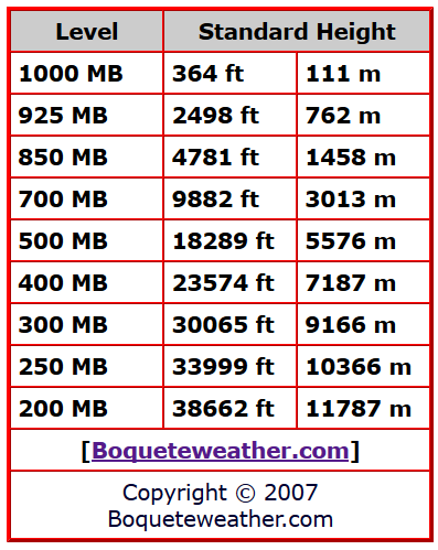
Isobars. These are the lines of equal pressure that run horizontally from left to right and are labeled on the left side of the diagram. Pressure is given in increments of 100 mb and ranges from 1000 mb to 100 mb. Spacing between the isobars increases in the vertical because of the log scale that is used to represent pressure.

The Chart below can be used to help and understand what height corresponds to the MB’s

MB Chart.png

B/ Dry Adiabats

dry adiabats.jpg

Dry Adiabats are slightly curved, solid lines that slant from lower right to upper left. They are labeled every 10 degrees Celsius and indicate the rate of change of temperature in an air parcel of dry air rising or descending adiabatically.

C/ Moist Adiabats

Moist adiabats.jpg

Saturation Adiabats are the slightly curved, solid lines sloping from lower right to upper left. They are labeled every 2 degrees Celsius and indicate the rate of change of temperature in a saturated air parcel as it rises pseudo-adiabatically. They become parallel to the dry Adiabats at the top of the chart because of the very low moisture content at those levels and stop at 200 mb.
D/ Isotherms

Isotherms.jpg

Credit: UCAR Comet Program Skew-T module
Isotherms are lines of constant temperature. They are the namesake of the Skew-T chart because they are skewed 45 degrees to the right. Skewing the Ts may seem a little unintuitive, but a Skew-T allows us to easily calculate important atmospheric levels and parameters like the Lifting Condensation Level (LCL), Level of Free Convection (LFC), the Equilibrium Level, and CAPE. A Stüve is like a Skew-T but without the skewed temperature lines. It is not as useful for most meteorological applications because the adiabats on it are not curved, meaning we can’t accurately calculate the things listed above.

E/ Saturation Mixing Ratio Lines

SMRL.jpg

Saturation Mixing Ratio Lines. These are the dashed and very slightly curved lines that slope from the lower left to the upper right that represent lines of equal mixing ratio. They are labeled on the bottom of the diagram in grams per kilogram of water vapor. They extend only to 200 mb and the spacing between them decreases as their values increase.

The next part, we will look at are the Barbs, wind direction and the sounding itself.

Cheers

Colin.

hopefully it all came across from word, I had upload all the pics again so hopefully everything is in order. I will do a reproof read but I have to run and get some things done. Took a bit longer than I thought.
Colin Maitland.
thanks 5 users thanked Colmait for this useful post.
thunderman on 27/09/2019(UTC), DelBoy on 27/09/2019(UTC), Falling_Droplet on 27/09/2019(UTC), i4hanish on 27/09/2019(UTC), squall19 on 28/09/2019(UTC)
Offline DelBoy  
#19 Posted : Friday, 27 September 2019 5:46:21 PM(UTC)
DelBoy

Rank: Advanced Member

Groups: Registered
Joined: 13/09/2019(UTC)
Posts: 118
Location: Caboolture (the next Las Vegas!)

Thanks: 215 times
Was thanked: 297 time(s) in 100 post(s)
Stunning stuff Colin!ThumpUp
thanks 3 users thanked DelBoy for this useful post.
Colmait on 27/09/2019(UTC), i4hanish on 27/09/2019(UTC), squall19 on 28/09/2019(UTC)
Offline i4hanish  
#20 Posted : Friday, 27 September 2019 8:01:05 PM(UTC)
i4hanish

Rank: Advanced Member

Groups: Registered
Joined: 15/09/2019(UTC)
Posts: 39
Australia
Location: Forster NSW mid coast

Thanks: 172 times
Was thanked: 135 time(s) in 39 post(s)
Absolutely Brilliant Colmait.Obviously a lot of work in compiling that information. Thank you so much.BigGrin Dancing

I will pit the link to todays storm discussions here as well.

I have questions of course but a little a little at a time. I have been enjoying watching the live learning in the SEQ thread as well.

LIVE storm watching practice.
https://www.weatherforum...-26-30th-Sept-2019/page2
thanks 3 users thanked i4hanish for this useful post.
Colmait on 27/09/2019(UTC), squall19 on 28/09/2019(UTC), Falling_Droplet on 28/09/2019(UTC)
Users browsing this topic
UnknownOceanSpiders 0.0
2 Pages12>
Forum Jump  
You cannot post new topics in this forum.
You cannot reply to topics in this forum.
You cannot delete your posts in this forum.
You cannot edit your posts in this forum.
You cannot create polls in this forum.
You cannot vote in polls in this forum.

Weather Forum

Weatherzone Forum Alternative

The Weather Forum for Australia

Australian Weather Forum

Weather Forum for Australia, climate change, storm chasing, cyclones, weather photography