Weather Forum

Welcome Guest! To enable all features please Login or Register.

Notification

Icon
Error

9 Pages«<6789>
Share
Options
Go to last post Go to first unread
Online Colmait  
#141 Posted : Friday, 10 October 2025 2:56:28 PM(UTC)
Colmait

Rank: Advanced Member

Groups: Registered, Administrators
Joined: 21/08/2019(UTC)
Posts: 767
Australia
Location: Brisbane Northside

Thanks: 1125 times
Was thanked: 954 time(s) in 509 post(s)
IMG_5325.jpeg
Colin Maitland.
thanks 1 user thanked Colmait for this useful post.
Aussie Girl on 11/10/2025(UTC)
Online Colmait  
#142 Posted : Friday, 10 October 2025 5:01:46 PM(UTC)
Colmait

Rank: Advanced Member

Groups: Registered, Administrators
Joined: 21/08/2019(UTC)
Posts: 767
Australia
Location: Brisbane Northside

Thanks: 1125 times
Was thanked: 954 time(s) in 509 post(s)
IMG_5326.jpeg
Colin Maitland.
thanks 1 user thanked Colmait for this useful post.
Aussie Girl on 11/10/2025(UTC)
Online Colmait  
#143 Posted : Friday, 10 October 2025 5:27:22 PM(UTC)
Colmait

Rank: Advanced Member

Groups: Registered, Administrators
Joined: 21/08/2019(UTC)
Posts: 767
Australia
Location: Brisbane Northside

Thanks: 1125 times
Was thanked: 954 time(s) in 509 post(s)
On the Satellite you can see the Ridge moving to the East.

West of Dalby there is a nice plump cell developing which may make its way to the Range and near Toowoomba this evening. The lack of sufficient moisture and heating East of the Range has played a part in storms struggling to form for Coastal areas. Even though there was a nice NE wind blowing it just wasn’t enough to feed into the atmosphere and the cap was still in place. There still could be a chance of a rumble or 2 this evening. ??? May and could are the big things here.

Also tomorrow may see a chance, but at this stage Sunday and Monday is a better setup . But it really is a case of looking at the set ups especially when the soundings become available each day.

Below is the lightning tracker dor the cell West of Dalby and also the Sat image.

IMG_5330.jpeg

IMG_5327.jpeg

Edited by user Friday, 10 October 2025 5:43:47 PM(UTC)  | Reason: Spelling

Colin Maitland.
thanks 1 user thanked Colmait for this useful post.
Aussie Girl on 11/10/2025(UTC)
Online Colmait  
#144 Posted : Friday, 10 October 2025 7:39:22 PM(UTC)
Colmait

Rank: Advanced Member

Groups: Registered, Administrators
Joined: 21/08/2019(UTC)
Posts: 767
Australia
Location: Brisbane Northside

Thanks: 1125 times
Was thanked: 954 time(s) in 509 post(s)
Latest STW and Radar.

IMG_5332.jpeg

IMG_5331.jpeg

Colin Maitland.
thanks 1 user thanked Colmait for this useful post.
Aussie Girl on 11/10/2025(UTC)
Online Colmait  
#145 Posted : Friday, 10 October 2025 8:43:52 PM(UTC)
Colmait

Rank: Advanced Member

Groups: Registered, Administrators
Joined: 21/08/2019(UTC)
Posts: 767
Australia
Location: Brisbane Northside

Thanks: 1125 times
Was thanked: 954 time(s) in 509 post(s)
Latest STW. 3cm hail reported at Goondiwindi. Also the latest radar sweep. IMG_4644.jpegIMG_4645.jpeg
Colin Maitland.
thanks 1 user thanked Colmait for this useful post.
Aussie Girl on 11/10/2025(UTC)
Offline Aussie Girl  
#146 Posted : Saturday, 11 October 2025 9:50:02 AM(UTC)
Aussie Girl

Rank: Advanced Member

Groups: Registered
Joined: 13/03/2024(UTC)
Posts: 117
Australia
Location: South East Qld

Thanks: 300 times
Was thanked: 113 time(s) in 112 post(s)
Thank you once again for all these updates Colmait. The bar graph you made is really good and simple to read.

It will be fantastic if storms and showers do happen on Sunday and Monday. Not hoping for a severe storm but some rain and showers would be wonderful for the South East.

BOM is showing the chance of showers for the Brisbane area over Sunday and Monday as high (70%). I guess we will have to wait and see though.

Here is the BOM forecast for Brisbane for the next few days:


BOM forecast 11.10.25.JPG
Online Colmait  
#147 Posted : Saturday, 11 October 2025 11:43:54 AM(UTC)
Colmait

Rank: Advanced Member

Groups: Registered, Administrators
Joined: 21/08/2019(UTC)
Posts: 767
Australia
Location: Brisbane Northside

Thanks: 1125 times
Was thanked: 954 time(s) in 509 post(s)
Your welcome @ Aussie Girl.

🌩️ Saturday Outlook – Southeast QLD & Northern NSW
Storm potential: Low to marginal
🔹 Overview of the set ups by triangulating the three sounding from Charleville, Moree and Brisbane.
Saturday’s setup looks largely suppressed across inland and coastal Southeast Queensland, extending into the Northern Rivers of NSW.
Despite some surface instability, dry mid-level air between 700–500 hPa is expected to cap convection and limit storm coverage.

* Key Features
Mid-level dryness: Strong around the Darling Downs and inland areas, preventing deep convection.
Surface conditions: Warm to hot inland, with limited low-level moisture depth.
Triggering: Weak overall — sea-breeze ororographic lift may help near the coast, but most regions remain capped.

* Regional Breakdown

🌤 Darling Downs / Toowoomba / Dalby: Very dry and capped. Little to no storm activity expected.

🌦️ Brisbane / Gold Coast / Northern Rivers: Slight chance of an isolated, high-based storm along coastal convergence zones.

🌞 Western Interior including Charleville: Hot, dry, and stable — no storms expected.

* Summary

Storm potential: 🟡 Low overall but keep an eye around the Moree area.
Main inhibitor: Mid-level dry air and weak lift.

Best (but still low) chance: Coastal SEQ or Northern Rivers under late-day sea-breeze convergence.

So we should mostly dry conditions, with just a few clouds struggling to break through the cap.

Sunday afternoon/ evening/ overnight and into Monday looks the best potential at this stage.

So the best things is to keep an eye to the sky and radar. If storms somehow or do develop, listen for any warnings if required.

Below is the 3 soundings

IMG_5336.jpeg

IMG_5333.jpeg

IMG_5334.jpeg

Edited by user Saturday, 11 October 2025 12:21:11 PM(UTC)  | Reason: Not specified

Colin Maitland.
thanks 1 user thanked Colmait for this useful post.
Aussie Girl on 11/10/2025(UTC)
Online Colmait  
#148 Posted : Saturday, 11 October 2025 11:44:39 AM(UTC)
Colmait

Rank: Advanced Member

Groups: Registered, Administrators
Joined: 21/08/2019(UTC)
Posts: 767
Australia
Location: Brisbane Northside

Thanks: 1125 times
Was thanked: 954 time(s) in 509 post(s)
IMG_5338.jpeg
Colin Maitland.
thanks 1 user thanked Colmait for this useful post.
Aussie Girl on 11/10/2025(UTC)
Online Colmait  
#149 Posted : Saturday, 11 October 2025 1:21:36 PM(UTC)
Colmait

Rank: Advanced Member

Groups: Registered, Administrators
Joined: 21/08/2019(UTC)
Posts: 767
Australia
Location: Brisbane Northside

Thanks: 1125 times
Was thanked: 954 time(s) in 509 post(s)
I thought I would post Bom’s forecast map and then compare it with the soundings and see the difference.


IMG_5342.jpeg


🌀 Saturday 11 October 2025 – BoM vs. Model-Based Outlook (SEQ & NE NSW)

The Bureau of Meteorology’s latest thunderstorm forecast (issued 9:36 am) paints a notably different scenario to what earlier model soundings and private analyses were indicating for today.
BoM Outlook Summary
Severe thunderstorms likely: Darling Downs & Granite Belt (Warwick–Stanthorpe corridor).
Severe thunderstorms possible: Extending west through the Maranoa & Warrego and north into the Wide Bay hinterland.

General thunderstorm potential: Broader inland coverage across the Central West and Gulf Country.
This suggests BoM sees focused severe potential in the far south-east, contrasting with the earlier guidance which kept instability more confined west and north of the Darling Downs.

Model and Sounding Discussion
Soundings through Toowoomba, Moree, and inland SEQ yesterday and early this morning highlighted several limiting factors:
CAPE: Generally low to moderate (100–300 J/kg), insufficient for widespread severe activity.

Capping layer: Noticeable around 700 mb, though weaker near Toowoomba, hinting at breakable inhibition under local lift.

Moisture: A persistent dry mid-level layer limiting sustained updraft depth and reducing storm coverage.

However, the Toowoomba sounding at 21Z (11 Oct) showed slightly improved boundary-layer moisture and a minor reduction in CIN, which could locally support convection near the southern border if surface heating aligns with trough convergence.

So why does BoM now go for a “severe likely” zone near Warwick–Stanthorpe?

Likely reasons include:
Localized convergence: Sharpening of the surface trough along the NSW border.
Orographic lift: Enhancement from the Granite Belt terrain.
Moisture pooling: Late-day boundary layer recovery possibly better than modelled by GFS.
Alternate guidance: BoM’s ACCESS-G suite may be showing stronger CAPE and slightly improved upper divergence.

Essentially, BoM is targeting a narrow corridor where these factors overlap — not a broad severe day, but an area where one or two isolated storms could reach severe thresholds if initiation occurs.


While models still indicate limited overall coverage due to dry mid-levels and marginal instability, BoM’s update supports keeping a close watch on the southern Downs and Granite Belt this afternoon.
If storms do break the cap, expect localized strong gusts, small hail, and brief heavy rainfall, mainly toward the border districts.
Elsewhere, conditions remain too capped or too dry aloft for significant activity.

So once again, keep an eye and ear out in case any storms do develop and a STW is required.

Edited by user Saturday, 11 October 2025 2:07:52 PM(UTC)  | Reason: Spelling

Colin Maitland.
thanks 1 user thanked Colmait for this useful post.
Aussie Girl on 11/10/2025(UTC)
Online Colmait  
#150 Posted : Saturday, 11 October 2025 8:11:00 PM(UTC)
Colmait

Rank: Advanced Member

Groups: Registered, Administrators
Joined: 21/08/2019(UTC)
Posts: 767
Australia
Location: Brisbane Northside

Thanks: 1125 times
Was thanked: 954 time(s) in 509 post(s)
It looks like that small chance that GFS and the models sounding that I mentioned for this afternoon for the Toowoomba and surrounds has been correct with its stormcasting.
A cell has managed to form and warrant a STW as per below

IMG_4646.jpeg

And the radar sweep. With the Mt Stapy 512K

IMG_4648.jpeg

And another small cell towards Warwick.

IMG_4647.jpeg

Edited by user Saturday, 11 October 2025 8:17:48 PM(UTC)  | Reason: Not specified

Colin Maitland.
thanks 1 user thanked Colmait for this useful post.
Aussie Girl on 12/10/2025(UTC)
Online Colmait  
#151 Posted : Sunday, 12 October 2025 9:08:23 AM(UTC)
Colmait

Rank: Advanced Member

Groups: Registered, Administrators
Joined: 21/08/2019(UTC)
Posts: 767
Australia
Location: Brisbane Northside

Thanks: 1125 times
Was thanked: 954 time(s) in 509 post(s)
🌩️ Sunday 12 October 2025 – Storm Outlook and rain potential

Technical Breakdown
Today’s setup is a classic example of how promising upper-level conditions can still fall flat when low-level moisture doesn’t want to play the ball.

Soundings from Brisbane, Toowoomba, Warwick, Dalby, and Moree all tell a similar story — a strong cap sitting firmly in place between roughly 850–700 hPa, combined with low dewpoints that limit parcel buoyancy. Surface moisture mixing has reduced dewpoints across the Downs and western regions, leading to CIN values too high for sustained convection.

CAPE is present but shallow, and the LCLs are too high for efficient storm initiation. Even if something does try to break the cap, updrafts will likely become more entrainment-loaded and collapse quickly.

When each profile is re-run with 19 °C dewpoints (a modest moisture increase), the picture changes dramatically:
The cap weakens enough to allow isolated updrafts.

CAPE rises notably, especially inland.

The overall storm structure potential improves — hinting that moisture alone is the missing link today.
So, in technical terms: the ingredients are half-baked. The atmosphere has the heat and lift, but not the moisture to get things cooking so to say.

To put it simply

It’s one of those days where it looks like storms could form — but the air near the surface is just too dry.

That invisible “lid” or cap on the atmosphere is holding things down tight.

Even though it’s warm enough and the upper winds look good, there just isn’t enough moisture to get proper storm clouds going.

If the air was a few degrees more humid — like those 19 °C dewpoints — we’d likely be seeing scattered storms bubbling up inland.

As it stands, expect a warm and dry afternoon, with maybe a few teasing cumulus towers that fizzle out quickly.
Storms today are unlikely, and any that do pop up will struggle to sustain themselves.

This is a great example of how one missing ingredient — in this case, moisture — can completely change the forecast outcome.
You could almost say we’re just one dewpoint away from a storm day!

Here is a comparison with the forecast soundings and then adding a modest amount of moisture into the mix.
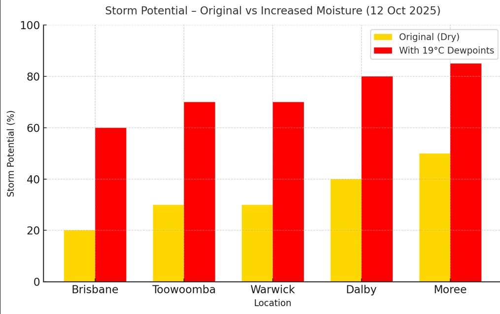
IMG_5366.jpeg

I will add the rain potential below as well. Today is looking dry but over the next 30 plus hours it does improve.

IMG_5348.jpeg

Plus 30 hours

IMG_5349.jpeg

We need to wait and see what the sounding is like as well from the balloons released this morning.

Please note that this is only my interpretation and things can be completely different . I didn’t even have time this morning to add the EC models into the equation.

BoM are running their forecast through supercomputers and are using an Access model that is not for the public then they are able to compare that with the European models that once again are not for public use. We can use a limited variation of the models for free or you can open things a bit wider by paying a subscription. But the fun is trying to forecast with limited modelling systems.

So please keep your eye and ears open to any warning or storms if they do build and become severe. Have a great day

Edited by user Sunday, 12 October 2025 9:41:56 AM(UTC)  | Reason: Spelling and adding charts

Colin Maitland.
thanks 1 user thanked Colmait for this useful post.
Aussie Girl on 12/10/2025(UTC)
Online Colmait  
#152 Posted : Sunday, 12 October 2025 11:05:45 AM(UTC)
Colmait

Rank: Advanced Member

Groups: Registered, Administrators
Joined: 21/08/2019(UTC)
Posts: 767
Australia
Location: Brisbane Northside

Thanks: 1125 times
Was thanked: 954 time(s) in 509 post(s)
BoM have released the latest sounding for Brisbane. It is interesting this morning I played around with the dew points as I thought the models had under done them. So in summary looking at the 3 soundings Model, Model with adjusted Dew points and the actual we have a slightly different picture. Not a great deal when comparing the last 2 soundings.

IMG_5354.jpeg


This is the version where I increased the dew points to 19°C

IMG_5355.jpeg

The actual sounding from the Airport.


IMG_5367.jpeg


Analysis of the charts

IMG_5368.jpeg

The GFS forecast clearly underestimated low-level moisture for Brisbane today, producing a deep dry layer with no CAPE and significant capping (CIN 137 J/kg). When a realistic 19°C surface dewpoint was introduced, CAPE jumped above 1500 J/kg, CIN reduced substantially, and the environment became conditionally unstable.

The observed sounding this morning verifies that outcome almost exactly — surface dewpoint near 19°C, similar CAPE (≈1200–1500 J/kg), and LI around -6°C. The cap is weak, and with surface heating to 33°C, the environment now supports isolated convective initiation if lifting mechanisms align.

Moisture depth and the higher PW (42.8 mm vs 34 mm forecast) confirm a much moister boundary layer than the model.

Shear remains moderate (~35–40 kt), enough to sustain organised updrafts should storms develop.
In summary — the real atmosphere followed the adjusted version, not the model. GFS missed the moisture return and therefore underplayed storm potential for SE QLD.

So to put that simply

Brisbane’s morning weather balloon shows a big difference from what the models had suggested. The real air is a lot more humid, with dewpoints around 19°C instead of the 13°C forecast.
That extra moisture means the atmosphere is more unstable, with energy now available for storms (CAPE around 1400 J/kg).

It’s still not a classic setup — we’ll need a bit of lift or a boundary to spark anything — but it explains why the air feels heavy and “stormy” today.
In short, the models were too dry, and the real atmosphere looks much more supportive of isolated afternoon storms, especially inland where heating is stronger.

So once again this is only my interpretation of events. So please keep an eye and ear out just in case. Being outside compared to looking at the charts and models gives you a different perspective, so that is why I thought I would re run or replot the models this morning and create a new sounding.
Cheers

Edited by user Sunday, 12 October 2025 11:24:32 AM(UTC)  | Reason: Wrong soundings from gallery DoH 😣

Colin Maitland.
thanks 1 user thanked Colmait for this useful post.
Aussie Girl on 12/10/2025(UTC)
Online Colmait  
#153 Posted : Sunday, 12 October 2025 4:18:16 PM(UTC)
Colmait

Rank: Advanced Member

Groups: Registered, Administrators
Joined: 21/08/2019(UTC)
Posts: 767
Australia
Location: Brisbane Northside

Thanks: 1125 times
Was thanked: 954 time(s) in 509 post(s)
A few cells popping up on the radar. Nothing severe but some lightning bolts being thrown out. Below is the radar sweep and the Energex Lightning tracker.

You could feel the humidity this afternoon and that was part of the needed ingredient to enhance storm potential.
There has been a very nice sea breeze feeding in from the North East. Maybe we may get a mm or so and hopefully this will carry over into the next few days. Not a lot is expected but anything would be appreciated.

IMG_5370.jpeg

IMG_5369.jpeg
Colin Maitland.
thanks 1 user thanked Colmait for this useful post.
Aussie Girl on 12/10/2025(UTC)
Online Colmait  
#154 Posted : Sunday, 12 October 2025 5:15:32 PM(UTC)
Colmait

Rank: Advanced Member

Groups: Registered, Administrators
Joined: 21/08/2019(UTC)
Posts: 767
Australia
Location: Brisbane Northside

Thanks: 1125 times
Was thanked: 954 time(s) in 509 post(s)
Storms have become severe and therefore a STW has been issued for storms just to the North of Brisbane. I would expect more cells to develop as the cells approach the Coast with the interaction with the sea breeze.

IMG_5371.jpeg

IMG_5372.jpeg
Colin Maitland.
thanks 1 user thanked Colmait for this useful post.
Aussie Girl on 12/10/2025(UTC)
Online Colmait  
#155 Posted : Sunday, 12 October 2025 5:47:35 PM(UTC)
Colmait

Rank: Advanced Member

Groups: Registered, Administrators
Joined: 21/08/2019(UTC)
Posts: 767
Australia
Location: Brisbane Northside

Thanks: 1125 times
Was thanked: 954 time(s) in 509 post(s)
The latest STW

IMG_5373.jpeg

Colin Maitland.
thanks 1 user thanked Colmait for this useful post.
Aussie Girl on 12/10/2025(UTC)
Online Colmait  
#156 Posted : Sunday, 12 October 2025 6:21:40 PM(UTC)
Colmait

Rank: Advanced Member

Groups: Registered, Administrators
Joined: 21/08/2019(UTC)
Posts: 767
Australia
Location: Brisbane Northside

Thanks: 1125 times
Was thanked: 954 time(s) in 509 post(s)
Storms have turned nasty. A dangerous cell has been detected.

Please stay vigilant.


6 CM HAILSTONES WERE OBSERVED AT BELLTHORPE AROUND 5:00 PM.

4 cm hailstones were observed at Stanmore around 5:15 pm.

Here is the latest STW and radar sweep of the current situation.

IMG_5374.jpeg

IMG_5375.jpeg
Colin Maitland.
thanks 1 user thanked Colmait for this useful post.
Aussie Girl on 12/10/2025(UTC)
Online Colmait  
#157 Posted : Sunday, 12 October 2025 7:12:14 PM(UTC)
Colmait

Rank: Advanced Member

Groups: Registered, Administrators
Joined: 21/08/2019(UTC)
Posts: 767
Australia
Location: Brisbane Northside

Thanks: 1125 times
Was thanked: 954 time(s) in 509 post(s)
Storms are becoming more wide spread to the North and slowly moving south towards the CBD. Storms should continue throughout the evening and possibly will build again tomorrow afternoon. So hopefully I will be able to have a bit more time and look at the models and see what the potential may look like.

The latest STW and radar imagery. I have also included the infrared + Zehr image from the Himawari-9 satellite. It highlights some of the extreme cold uppers in this afternoon storm allowing for the hail to form. The storm further west looks like a bit of a beast.

IMG_5377.jpeg

IMG_5378.jpeg

IMG_5376.jpeg

Colin Maitland.
thanks 1 user thanked Colmait for this useful post.
Aussie Girl on 12/10/2025(UTC)
Online Colmait  
#158 Posted : Sunday, 12 October 2025 7:36:08 PM(UTC)
Colmait

Rank: Advanced Member

Groups: Registered, Administrators
Joined: 21/08/2019(UTC)
Posts: 767
Australia
Location: Brisbane Northside

Thanks: 1125 times
Was thanked: 954 time(s) in 509 post(s)
Latest STW with another Dangerous Cell being labeled. Also the radar image from Toowoomba. It appears the is some rotation in that dangerous cell .

IMG_5382.jpeg

IMG_5382.jpeg

Also the latest STW

IMG_5384.jpeg
Colin Maitland.
thanks 1 user thanked Colmait for this useful post.
Aussie Girl on 12/10/2025(UTC)
Online Colmait  
#159 Posted : Sunday, 12 October 2025 8:53:03 PM(UTC)
Colmait

Rank: Advanced Member

Groups: Registered, Administrators
Joined: 21/08/2019(UTC)
Posts: 767
Australia
Location: Brisbane Northside

Thanks: 1125 times
Was thanked: 954 time(s) in 509 post(s)
Looks like we could be in for a long night. That Dangerous labelled cell mentioned in the previous post produced 5 CM HAILSTONES WERE OBSERVED AT JIMNA AT 7:30 PM. ( As per the latest STW. )
Below is the latest STW, 128K Mt Stapy radar and the 512K radar showing the broader storm system moving to the East.

IMG_4652.jpeg

IMG_4650.jpeg

IMG_4651.jpeg

Edited by user Sunday, 12 October 2025 8:53:56 PM(UTC)  | Reason: Not specified

Colin Maitland.
thanks 1 user thanked Colmait for this useful post.
Aussie Girl on 12/10/2025(UTC)
Offline Aussie Girl  
#160 Posted : Sunday, 12 October 2025 10:00:13 PM(UTC)
Aussie Girl

Rank: Advanced Member

Groups: Registered
Joined: 13/03/2024(UTC)
Posts: 117
Australia
Location: South East Qld

Thanks: 300 times
Was thanked: 113 time(s) in 112 post(s)
Thank you once again for keeping us updated Colmait. It looks like it has been a busy afternoon and evening for you with all these storms.

It is still thundering here and best of all we are getting plenty of rain and there is more to come.


This is the 128km Mt Stapylton Radar image from 9.45pm this evening:


128 km Mt Stapylton Radar 9.45 pm 12.10.25.JPG


And this is the BOM rainfall image as at 9.42pm this evening with some areas of the map showing rainfall totals of between 50 and 100mls so far.


Rainfall 12.10.25.JPG
thanks 1 user thanked Aussie Girl for this useful post.
Colmait on 12/10/2025(UTC)
Users browsing this topic
Colmait, Guest (2)
9 Pages«<6789>
Forum Jump  
You cannot post new topics in this forum.
You cannot reply to topics in this forum.
You cannot delete your posts in this forum.
You cannot edit your posts in this forum.
You cannot create polls in this forum.
You cannot vote in polls in this forum.

Weather Forum

Weatherzone Forum Alternative

The Weather Forum for Australia

Australian Weather Forum

Weather Forum for Australia, climate change, storm chasing, cyclones, weather photography